
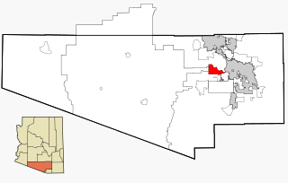
Corona de Tucson is a census-designated place (CDP) in Pima County, Arizona, United States. The population was 9,240 at the 2020 census, an increase of 1036% from the 2000 population of 813.
Tucson Estates is a census-designated place (CDP) in Pima County, Arizona, United States. The population was 9,755 at the 2000 census.

Cordes Lakes is a census-designated place (CDP) in Yavapai County, Arizona, United States. The population was 2,058 at the 2000 census. The Agua Fria National Monument lies to the east and south of the community and Arcosanti is to the north.

Fortuna Foothills is a census-designated place (CDP) in Yuma County, Arizona, United States. The population was 26,265 at the 2010 census. It is part of the Yuma Metropolitan Statistical Area. Development of the area began in the 1960s, when local developer Hank Schechert purchased 3,000 acres east of Yuma. Fortuna Foothills serves as a bedroom community for Yuma, Yuma Proving Ground, and Marine Corps Air Station Yuma. Fortuna Foothills is also an area with a large amount of seasonal residents.
East San Gabriel is a census-designated place (CDP) in Los Angeles County, California, United States. The population was 14,874 at the 2010 census, up from 14,512 at the 2000 census.

Foothill Ranch is a master planned community in Orange County, California, United States. The population was 10,899 at the 2000 census. Foothill Ranch was incorporated into the city of Lake Forest, California, in 2000. Prior to that, it was a census-designated place.

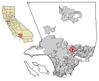
North Tustin is a census-designated place and unincorporated community in Orange County, California. The population was 24,917 at the 2010 census, up from 24,044 at the 2000 census. It is Orange County's largest census-designated place. It is outside the city limits of Tustin and has 92705 and 92780 ZIP Codes. The CDP name was changed from Tustin Foothills in 2005. North Tustin is the largest unincorporated community in Orange County.

East Shore is a census-designated place (CDP) in Plumas County, California, United States. The population was 156 at the 2010 census, down from 177 at the 2000 census.

East Hemet is a census-designated place (CDP) in Riverside County, California, United States, located east of Hemet. East Hemet is in an unincorporated area outside the city limits of Hemet. The population was 17,418 at the 2010 census, up from 14,823 at the 2000 census.

Foothill Farms is a census-designated place (CDP) and unincorporated community in Sacramento County, California, USA. It is part of the Sacramento–Arden-Arcade–Roseville Metropolitan Statistical Area. The population was 33,121 at the 2010 census, up from 17,426 at the 2000 census. Foothill Farms is part of the greater North Highlands-Foothill Farms community, and comprises the zip codes 95841 and 95842. Susan Ual services as President of the New Foothill Farms Community Association while Michael Baker services as the President of the Old Foothill Farms Community Association
www.oldfoothillfarms.org

San Antonio Heights is a census-designated place (CDP) in the San Bernardino County, California. It is in the northern Pomona Valley and the foothills of the San Gabriel Mountains. The population was 3,371 at the 2010 census, up from 3,122 at the 2000 census.

Pine Valley is a community and census-designated place (CDP) in the Cuyamaca Mountains of the Mountain Empire area, in southeastern San Diego County, California. The population was 1,510 at the 2010 census, up from 1,501 at the 2000 census.

Mission Canyon is a census-designated place and an unincorporated suburb of Santa Barbara, California, in Santa Barbara County, United States. The population was 2,381 at the 2010 census, down from 2,610 at the 2000 census.
East Orosi is a census-designated place (CDP) in Tulare County, California, United States. The population was 495 at the 2010 census, up from 426 in 2000.

Lemon Cove is a census-designated place (CDP) in the San Joaquin Valley in Tulare County, California, United States. The population was 308 at the 2010 census, up from 298 at the 2000 census.

Wailua Homesteads is a census-designated place (CDP) in Kauaʻi County, Hawaiʻi, United States. The population was 5,863 at the 2020 census, up from 4,567 at the 2000 census.

East Porterville is an unincorporated community in Tulare County, California, United States. Adjacent to the city of Porterville, the community lies by the Sierra Nevada foothills. The population was 7,331 at the 2010 census, up from 6,730 at the 2000 census. For statistical purposes, the United States Census Bureau has defined East Porterville as a census-designated place (CDP). The census definition of the area may not precisely correspond to local understanding of the area with the same name.

East Freehold is an unincorporated community and census-designated place (CDP) located within Freehold Township, in Monmouth County, New Jersey, United States. As of the 2010 United States Census, the CDP's population was 4,894.

Sturgeon-Noblestown was a census-designated place (CDP) for the 2000 United States Census in Allegheny County, Pennsylvania, United States. The population was 1,764 at that time. In the 2010 census the CDP was split into the two separate CDP's of Sturgeon and Noblestown.

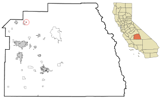
Yosemite Lakes Park is an unincorporated community in Madera County, California. It lies at an elevation of 1,230 feet (370 m). As a census-designated place (CDP) it is known as Yosemite Lakes. It is part of the Madera Metropolitan Statistical Area. The population was 5,022 at the 2020 census.


