
Los Gatos is an incorporated town in Santa Clara County, California, United States. The population is 33,529 according to the 2020 census. It is located in the San Francisco Bay Area just southwest of San Jose in the foothills of the Santa Cruz Mountains. Los Gatos is part of Silicon Valley, with several high technology companies maintaining a presence there. Notably, Netflix, the streaming service and content creator, is headquartered in Los Gatos and has developed a large presence in the area.

The Guadalupe River mainstem is an urban, northward flowing 14 miles (23 km) river in California whose much longer headwater creeks originate in the Santa Cruz Mountains. The river mainstem now begins on the Santa Clara Valley floor when Los Alamitos Creek exits Lake Almaden and joins Guadalupe Creek just downstream of Coleman Road in San Jose, California. From here it flows north through San Jose, where it receives Los Gatos Creek, a major tributary. The Guadalupe River serves as the eastern boundary of the City of Santa Clara and the western boundary of Alviso, and after coursing through San José, it empties into south San Francisco Bay at the Alviso Slough.

State Route 17 is a state highway in the U.S. state of California that runs from State Route 1 in Santa Cruz to I-280 and I-880 in San Jose. SR 17, a freeway and expressway, carries substantial commuter and vacation traffic through the Santa Cruz Mountains at Patchen Pass between Santa Cruz and the San Francisco Bay Area.

The Los Gatos Creek Trail is a 9.7-mile (15.6 km) pedestrian and bicycle trail that runs through western Santa Clara County in California, from Lexington Reservoir in Los Gatos, California through Campbell, California to Meridian Avenue in San Jose, California alongside Los Gatos Creek. The trail is heavily used.

Vasona Lake County Park is a park located in Los Gatos, California and part of the Santa Clara County Parks system. Vasona Park surrounds the Vasona Reservoir. Adjacent to the park are the Billy Jones Wildcat Railroad, a ridable miniature railway, and the W.E. "Bill" Mason Carousel at the Oak Meadow Park.

Redwood Estates is a rural unincorporated community along State Route 17 in the coastal Santa Cruz Mountains in Los Gatos, California, United States. The Census Bureau includes it in a census-designated place named Lexington Hills. It lies inside the confines of Santa Clara County. The area is about eight miles from downtown Los Gatos and nine miles from the Santa Cruz County community of Scotts Valley.
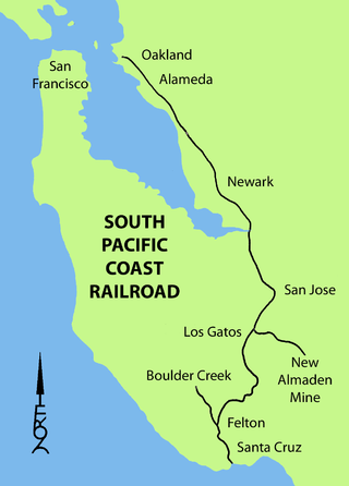
The South Pacific Coast Railroad (SPC) was a 3 ft narrow gauge steam railroad running between Santa Cruz, California and Alameda, with a ferry connection in Alameda to San Francisco. The railroad was created as the Santa Clara Valley Railroad, founded by local strawberry growers as a way to get their crops to market in San Francisco and provide an alternative to the Southern Pacific Railroad. In 1876, James Graham Fair, a Comstock Lode silver baron, bought the line and extended it into the Santa Cruz Mountains to capture the significant lumber traffic coming out of the redwood forests. The narrow-gauge line was originally laid with 52-pound-per-yard (26 kg/m) rail on 8-foot (2.44 m) redwood ties; and was later acquired by the Southern Pacific and converted to 4 ft 8+1⁄2 instandard gauge.

The Los Gatos Creek runs 24 miles (39 km) in California through Santa Clara Valley Water District's Guadalupe Watershed from the Santa Cruz Mountains northward through the Santa Clara Valley until its confluence with the Guadalupe River in downtown San Jose. The Guadalupe River then continues onward into San Francisco Bay.

Lexington Reservoir is an artificial lake on the Los Gatos Creek near Los Gatos, California. The James J. Lenihan Dam, a 195 ft (59 m) high, 1,000 ft (300 m) thick earthen dam, forms the third-largest reservoir in Santa Clara County.

First Pull Up, Then Pull Down is the second album by Hot Tuna, released in 1971 as RCA Victor LSP-4550. The album was recorded live with electric instruments, instead of the acoustic instruments used on the previous album, Hot Tuna. The album rose to No. 43 on the Billboard charts. In 1996, RCA released the CD box set Hot Tuna in a Can, which included a remastered version of this album, along with remasters of the albums Hot Tuna, Burgers, America's Choice and Hoppkorv. In Canada, the album reached No. 30 in the RPM Magazine charts where it was shown as Hot Tuna Electric Recorded Live.

Wrights, California is a ghost town in unincorporated west Santa Clara County, California. It is located near Summit Road in the Santa Cruz Mountains, on the north bank of Los Gatos Creek, east of State Route 17.

Laurel is a ghost town in Santa Cruz County, California, United States, in the Santa Cruz Mountains. It is in a valley at an elevation of 900 feet (270 m) above sea level.

Alma is a ghost town and drowned town in Santa Clara County in California, United States. It lies beneath the waters of the Lexington Reservoir above Los Gatos. The location is latitude 37.18N and longitude 121.98W. It was 551 feet above sea level.

Patchen is a ghost town nestled in the Santa Cruz Mountains, in Santa Clara County, California. It is located along the old Santa Cruz Highway.

Glenwood, California, is an unincorporated area of Santa Cruz County. It is located at coordinates 37°6′29″N121°59′8″W, and is 891 feet above sea level.
Clems, California is a ghost town in Santa Cruz County with an elevation of 790 feet. It is located a latitude 37055N, longitude 1215947W; decimal degrees: latitude 37.09806, longitude -121.99639.
Patchen Pass is a low mountain pass through the Santa Cruz Mountains of California, connecting the Santa Clara Valley to Santa Cruz and the Pacific coast. California State Route 17 traverses the pass at the Santa Clara–Santa Cruz county line, just south where the highway intersects with California State Route 35.
The Bear Creek Redwoods Open Space Preserve is a public open space preserve in the Santa Cruz Mountains. The preserve is located along both sides of Bear Creek Road, west of State Route 17 and Lexington Reservoir, and mostly north and east of the Skyline Boulevard and Summit Road sections of State Route 35. It surrounds the Presentation Center, a conference and retreat facility run by the Sisters of Presentation.
Trout Creek is a 1.8-mile-long (2.9 km) southeastward-flowing stream originating in the Santa Cruz Mountains, a tributary of Los Gatos Creek in Santa Clara County, California. From its confluence with Los Gatos Creek, its waters flow to the Guadalupe River and thence through San Jose, California to south San Francisco Bay.

