East Nusa Tenggara is the southernmost province of Indonesia. It comprises the eastern portion of the Lesser Sunda Islands, facing the Indian Ocean in the south and the Flores Sea in the north. It consists of more than 500 islands, with the largest ones being Sumba, Flores, and the western part of Timor; the latter shares a land border with the separate nation of East Timor. The province is subdivided into twenty-one regencies and the regency-level city of Kupang, which is the capital and largest city.

Nunukan Regency is a regency of North Kalimantan Province in Indonesia. It was created on 4 October 1999 from the northern districts of Bulungan Regency. Nunukan Regency shares international borders with the Malaysian states of Sabah to the north and Sarawak to the west, and inter-regency borders with Tana Tidung Regency and Malinau Regency to the south, as well as the coastal city of Tarakan in the east. The regency covers an area of 14,247.50 km2 and it had a population of 140,841 at the 2010 census and 199,090 at the 2020 census; the official estimate as at mid 2022 was 208,303.

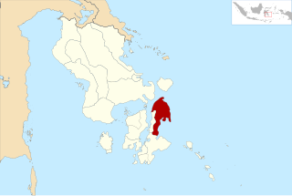
Ende is the seat capital of the Ende Regency, East Nusa Tenggara province of Indonesia. Ende is located on the southern coast of Flores Island. The town had a population of 87,269 residents at the 2020 census, divided administratively between four districts (kecamatan) of the regency – Ende Selatan, Ende Timur, Ende Tengah, and Ende Utara. Note that this does not include Ende District. The official estimate as at mid 2023 was 88,921.

Tangerang Regency is a regency of Banten Province, Indonesia. It is located in the northwest of the island of Java. The current regent is Ahmed Zaki Iskandar. Though commonly misunderstood as being a part of Jakarta, Tangerang is actually outside Jakarta City but is part of Greater Jakarta. Since 1993, the regency has lost territory as first Tangerang city was split off on 27 February 1993 and subsequently South Tangerang city was split off on 29 October 2008. The residual Regency now has an area of 1,034.54 km2 and a population of 2,834,376 at the 2010 census, growing to 3,245,619 at the 2020 census; the latest official estimate is 3,309,365, reflecting a recent slowing down in the rate of population growth since 2020. The town of Tigaraksa is the regency seat.

South Hulu Sungai Regency is one of the regencies (kabupaten) in South Kalimantan province, Indonesia. It had an area of 1,804.94 km2, and a population of 212,485 at the 2010 Census and 228,006 at the 2020 Census; the official estimate as at mid 2022 was 232,212. The capital of the regency is the town of Kandangan, which is famous for its culinary ketupat Kandangan.
Central Hulu Sungai Regency is one of the regencies in the Indonesian province of South Kalimantan. The area is 1,770.77 km2 and the population was 243,460 at the 2010 Census and 258,721 at the 2020 Census; the official estimate as at mid 2022 was 263,061. The administrative centre is the town of Barabai.
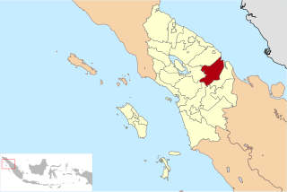
North Labuhanbatu Regency is a regency of North Sumatra, Indonesia, created on 21 July 2008 by being carved out of the north-western districts of the existing Labuhanbatu Regency, which until 2008 covered an area of 9,703 square kilometres and had a population of 840,382 according to the 2000 census. 60.99% of the regency is forested. The new North Labuhanbatu Regency covers 3,545.8 square kilometres and had a population of 331,660 at the 2010 Census, rising to 381,994 at the 2020 Census; the official estimate as at mid 2023 was 401,863 . The Kualuh River is located in this regency. The administrative centre of the regency is at the town of Aek Kanopan.

Dogiyai Regency is one of the regencies (kabupaten) in the Indonesian province of Central Papua. It covers an area of 7,052.92 km2, and had a population of 84,230 at the 2010 Census and 116,206 at the 2020 Census; the official estimate as at mid 2022 was 119,815, comprising 62,373 males and 57,442 females. The administrative centre is the town of Kigamani.

West Manggarai Regency is one of the eight regencies which comprise the island of Flores, located in the province of East Nusa Tenggara in Indonesia. The Regency was created on 25 February 2003 by the separation off of the western districts from Manggarai Regency. It covers a land area of 3,141.47 km2, and had a population of 221,703 at the 2010 census, rising to 251,689 at the 2015 Intermediate census and to 256,317 at the 2020 census. The official estimate as at mid 2023 was 270,917. The regency's capital is the town of Labuan Bajo.

Manggarai Regency is a regency in East Nusa Tenggara province of Indonesia, situated on the island of Flores. Established in 1958 the regency was reduced in size and population by the separation of the more western districts to form West Manggarai Regency in 2003 and of the more eastern districts to form East Manggarai Regency in 2007. The area of the residual Manggarai Regency is 1,343.83 km2 and its population was 292,037 at the 2010 census and 312,855 at the 2020 census; the official estimate as at mid 2023 was 328,758. The capital of the regency is the town of Ruteng.

Muara Enim Regency is a regency of South Sumatra Province, Indonesia. The regency seat is the town of Muara Enim. The city of Prabumulih is an administrative body separating the main part of Muara Enim to the south of the city from a smaller part to its north. The regency until late 2012 covered an area of 8,587.94 km² and had a population of 717,717 at the 2010 Census; however, on 14 December 2012 five districts from the Muara Enim Regency were split off to form the new Penukal Abab Lematang Ilir Regency.

North Barito Regency is one of the thirteen regencies which divide the Central Kalimantan Province on the island of Kalimantan, Indonesia. It originally included much more of the northern part of the province, but on 10 April 2002 the larger northwestern part of the regency was split off to create a new Murung Raya Regency. Muara Teweh is the capital of North Barito Regency, which covers an area of 10,152.25 km2. The population of North Barito Regency was 121,573 at the 2010 Census and 154,812 at the 2020 Census; the official estimate as at mid 2022 was 160,235.
Pringsewu Regency is a regency of Lampung Province, Sumatra, Indonesia. It has an area of 625 km² and had a population of 364,825 people at the 2010 Census and 405,466 at the 2020 Census; the official estimate as at mid 2022 was 408,415. The regency seat is the town of Pringsewu, located 37 kilometres from the provincial capital of Bandar Lampung. The regency was created on 29 October 2008 from the former eastern part of Tanggamus Regency.

Tanggamus Regency is a regency (kabupaten) of Lampung Province, Sumatra, Indonesia. It has an area of 4,654.96 km² and had a population of 534,595 at the 2010 Census and 640,275 at the 2020 Census; the official estimate as at mid 2022 was 652,898. The regency seat is the town of Kota Agung Pusat. The regency was created on 21 March 1997, but districts in its eastern part were split away on 29 October 2008 to form a new Pringsewu Regency. It lies in the southwest of the province, and surrounds Semangka Bay on its west, north and east coasts.

Takalar Regency is a regency of South Sulawesi Province, Indonesia. It covers an area of 566.51 km2 and had a population of 269,603 at the 2010 census and 300,853 at the 2020 census; the official estimate for mid 2022 was 305,077. The entire regency lies within the official metropolitan area of the city of Makassar. The principal towns are at Galesong and Takalar, but the administrative centre is at Pattallassang.
North Buton Regency is a regency of Indonesia's Southeast Sulawesi Province, which was separated from Buton Regency in accordance with Indonesia's Law Number 14 of 2007. The area of the regency, which covers the north part of Buton Island, is 1,923.03 km2. Its population was 54,736 at the 2010 Census and 66,653 at the 2020 Census; the official estimate as at mid 2022 was 69,051. The administrative capital of the regency is at the town of Buranga.

Maybrat Regency is a regency of Southwest Papua Province of Indonesia. It has an area of 5,461.69 km2 (2,108.77 sq mi), and had a population of 33,081 at the 2010 Census and 42,991 at the 2020 Census; the official estimate as at mid 2022 was 44,812. The administrative centre is the town of Kumurkek, in Aifat Dstrict. The Maybrat language is spoken in the regency.

Penukal Abab Lematang Ilir Regency is a regency of South Sumatra Province, Indonesia. It takes its name from the three main rivers which flow through that area - the Penukal River, Abab River and Lematang River - while the name Ilir means "downstream". The town of Talang Ubi is the administrative centre of this regency. The regency borders Musi Banyuasin Regency to the north, Banyuasin Regency, and Muara Enim Regency to the east and the south, and by Musi Rawas Regency, and Muara Enim Regency to the west.