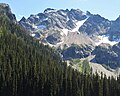
Cashmere Mountain is an 8,501-foot (2,591-metre) mountain summit located in Chelan County of Washington state. Cashmere Mountain is situated within the Alpine Lakes Wilderness, on land managed by the Okanogan–Wenatchee National Forest. It is part of the Wenatchee Mountains which are subset of the Cascade Range. Its nearest higher neighbor is Cannon Mountain, 4.4 mi (7.1 km) to the southeast. Precipitation runoff from this mountain drains into tributaries of Icicle Creek, which in turn is a tributary of the Wenatchee River.

Buck Mountain is an 8,528-foot (2,599-metre) mountain summit located in the Glacier Peak Wilderness of the North Cascades in Washington state. The mountain is situated in Chelan County, in the Wenatchee National Forest. Its nearest higher peak is Clark Mountain, 3.98 mi (6.41 km) to the southwest, and Brahma Peak is set 1.8 mi (2.9 km) to the south. Precipitation runoff from it drains into Buck Creek, Chiwawa River, and Napeequa River, each a tributary of the Wenatchee River. The mountain's name was applied by Albert Hale Sylvester (1871-1944), a pioneer surveyor, explorer, topographer, and forest supervisor in the Cascades.

Luahna Peak is an 8,400+ ft double summit mountain located in the Glacier Peak Wilderness of the North Cascades in Washington state. The true summit is 7400+ feet in elevation, and the northwest subpeak is 8,320+ feet. The mountain is situated in Chelan County, in the Wenatchee National Forest. Luahna Peak is the second highest in the Dakobed Range after Clark Mountain which is 1.04 mi (1.67 km) to the southeast, and Luahna lies 6.95 mi (11.18 km) southeast of Glacier Peak. The Richardson Glacier lies to the southeast of the summit, with the Pilz Glacier and Butterfly Glacier stretching across the northern slope. Precipitation runoff from the peak drains into the White River and Napeequa River, both tributaries of the Wenatchee River.

Tupshin Peak is an 8,320+ ft mountain summit located in the Glacier Peak Wilderness of the North Cascades in Washington state. The mountain is situated in Chelan County, on land managed by Wenatchee National Forest. Its nearest higher peak is Devore Peak, 1.55 mi (2.49 km) to the south-southwest, and Bonanza Peak lies 6.71 mi (10.80 km) to the southwest. Precipitation runoff from the peak drains to nearby Lake Chelan via tributaries of the Stehekin River. The mountain's name comes from Chinook jargon and means "needle".

Napeequa Peak is an 8,073-foot (2,461-metre) pyramidal mountain summit located in the Glacier Peak Wilderness of the North Cascades in Washington state. The mountain is situated on the crest of the Cascade Range, on the shared border of Snohomish County and Chelan County, also straddling the boundary between the Mount Baker-Snoqualmie National Forest and the Wenatchee National Forest. Its nearest neighbor is Cirque Mountain, 0.3 mi (0.48 km) to the north, and the nearest higher peak is Buck Mountain, 2.56 mi (4.12 km) to the east-southeast. Precipitation runoff from the peak drains east to the headwaters of Napeequa River; or west into the Suiattle River. The mountain's name is taken from the river's name, which was applied by Albert Hale Sylvester (1871-1944), a pioneer surveyor, explorer, topographer, and forest supervisor in the Cascades.

Copper Peak is an 8,964-foot (2,732-metre) mountain summit located in the Entiat Mountains, a sub-range of the North Cascades, in Chelan County of Washington state. Copper Peak is situated 80 miles northeast of Seattle in the Glacier Peak Wilderness, on land managed by the Wenatchee National Forest. Copper Peak ranks 22nd on Washington's highest 100 peaks, and 19th on the "Bulger List". The nearest higher peak is Mount Fernow, 0.88 miles (1.42 km) to the south. Precipitation runoff from the mountain and meltwater from the glacier on the southeast slope drains into nearby Lake Chelan via Railroad Creek. The first ascent of the peak was made in August 1937 by Franklin Bennet, Edgar Courtwright, and Toivo Hagman. The peak's name refers to an abandoned copper mine that once operated at the northeast base of the peak.

Spectacle Buttes are a pair of mountain summits located in the Entiat Mountains, a sub-range of the North Cascades, in Chelan County of Washington state. The pyramid-shaped south summit is 8,392-foot (2,558-metre) in elevation, and the lower north butte is 8,080-foot (2,460-metre) in elevation. Spectacle Buttes are situated 77 miles northeast of Seattle in the Glacier Peak Wilderness, on land managed by the Wenatchee National Forest. Spectacle Buttes ranks 78th on Washington's highest 100 peaks, 81st on the "Bulger List", and seventh-highest in the Entiat Mountains. The nearest higher peak is Marmot Pyramid on Mount Maude, 1.9 miles (3.1 km) to the west-northwest. Precipitation runoff from the peaks drains into headwaters of the Entiat River. The first ascent of the south peak was made by Rowland Tabor and Dwight Crowder on August 20, 1953.

Finney Peak is an 8,110-foot (2,470-metre) mountain summit located West of Sawtooth Ridge(The Sawtooths), a sub-range of the North Cascades in Chelan County of Washington state. Finney Peak is situated within the Lake Chelan-Sawtooth Wilderness on land managed by the Okanogan–Wenatchee National Forest. The nearest higher peak is Star Peak, 3 miles (4.8 km) to the northeast. Precipitation runoff from the mountain drains into nearby Lake Chelan via Prince Creek and Cascade Creek.

Brahma Peak is a remote 8,078-foot (2,462-metre) mountain summit located on Chiwawa Ridge in the North Cascades, in Chelan County of Washington state. The mountain is situated in the Glacier Peak Wilderness, on land managed by the Wenatchee National Forest. Its nearest higher neighbor is Buck Mountain, 1.8 mi (2.9 km) to the north. Brahma and Buck are set on Chiwawa Ridge, and other notable peaks on this ridge include Fortress Mountain, Cirque Mountain, Napeequa Peak, Mount Berge, Bandit Peak, and Chiwawa Mountain. Precipitation runoff from Brahma and meltwater from its glacier remnants drains into Chiwawa River and Napeequa River, both tributaries of the Wenatchee River. Topographic relief is significant since the southwest lavender-colored schist cliffs of this peak rise nearly 4,000 feet above the Napeequa River Valley in approximately one mile.

Saska Peak is an 8,404 ft (2,560 m) mountain summit located in the Chelan Mountains, in Chelan County of Washington state. The mountain is situated in Glacier Peak Wilderness of the North Cascades, on land managed by Wenatchee National Forest. Saska Peak ranks as the third-highest peak in the Chelan Mountains, and 74th-highest summit in Washington state. Its nearest higher neighbor is Emerald Peak, 0.66 mi (1.06 km) to the east-northeast, and Cardinal Peak is positioned 1.52 mi (2.45 km) to the east-southeast. These three highest peaks of the Chelan Mountains enclose the head of North Fork Entiat River valley. Precipitation runoff from the peak drains into the Entiat River drainage basin. The mountain's name honors Shil-how-Saskt, Tribal chief of the Entiat people, and was applied by Albert Hale Sylvester (1871-1944), a pioneer surveyor, topographer, and forest supervisor who named thousands of geographic features in the Cascades. In the Columbia-Moses language (Salishan), this name means "Standing in the middle of the sky."

Mount Arriva is an 8,215 ft (2,500 m) elevation mountain summit located in the North Cascades in the U.S. state of Washington. It is situated in North Cascades National Park, on the shared border of Chelan County and Skagit County. Despite its position only 1.55 mi (2.49 km) southwest of Easy Pass, and 3.7 mi (6.0 km) west of the North Cascades Highway, it is not visible from either. Its nearest higher peak is Black Peak, 2.57 mi (4.14 km) to the southeast. Mount Arriva has a secondary summit, called East Peak, which was first climbed in August 1940 by Fred Beckey, Jim Crooks, and Ed Kennedy. The first ascent of the true summit was made July 6, 1966, by Joe and Joan Firey, John and Irene Meulemans.

Cirque Mountain is a 7,966-foot (2,428-metre) mountain summit located in the Glacier Peak Wilderness of the North Cascades in Washington state. The mountain is situated on the crest of the Cascade Range, on the shared border of Snohomish County and Chelan County, also straddling the boundary between the Mount Baker-Snoqualmie National Forest and the Wenatchee National Forest. Its nearest higher peak is Napeequa Peak, 0.3 mi (0.48 km) to the south. The peak is set on Chiwawa Ridge with Napeequa, and other notable peaks on this ridge include Fortress Mountain, Buck Mountain, Brahma Peak, Mount Berge, and Chiwawa Mountain. Topographic relief is significant since the western aspect of the mountain rises 4,000 feet above the Suiattle Valley in approximately 1.5 mi (2.4 km). This mountain has small, unnamed, hanging glaciers in cirques surrounding the summit. Precipitation runoff from the peak and meltwater from the glaciers drains east to the headwaters of Napeequa River; or west into the Suiattle River.

Pinnacle Mountain is an 8,400+ ft granitic multi-peak massif located in the Chelan Mountains, in Chelan County of Washington state. The mountain is situated in Glacier Peak Wilderness of the North Cascades, on land managed by Wenatchee National Forest. Fred Beckey's Cascade Alpine Guide has the elevation of the highest pinnacle as 8,402 feet. Pinnacle Mountain ranks as the fourth-highest peak in the Chelan Mountains, and 75th-highest summit in Washington state. Its nearest higher neighbor is Saska Peak, 1.9 mi (3.1 km) to the southeast, and Emerald Peak is positioned 2.25 mi (3.62 km) to the east-southeast. Precipitation runoff from the peak drains into the Entiat River and Chelan River drainage basins.

Tenpeak Mountain is an 8,200+ ft granitic mountain summit located in the Glacier Peak Wilderness of the North Cascades in Washington state. Fred Beckey's Cascade Alpine Guide has the elevation of the mountain as 8,281 feet. Tenpeak is situated on the crest of the Cascade Range, on the shared border of Snohomish County and Chelan County, also straddling the boundary between the Mount Baker-Snoqualmie National Forest and the Wenatchee National Forest. Its nearest higher neighbor is Luahna Peak, 2.5 mi (4.0 km) to the southeast. Topographic relief is significant since the northern aspect of the mountain rises 4,200 feet above the Suiattle Valley in approximately 1.5 mi (2.4 km). This mountain has small, unnamed, hanging glaciers in cirques surrounding the summit, and the terminus of the Honeycomb Glacier lies below the western base of the mountain. Precipitation runoff from the mountain and meltwater from the glaciers drains south into White River; or north into the Suiattle River. This mountain's descriptive name was suggested by The Mountaineers, and was officially adopted in 1918 by the U.S. Board on Geographic Names. The first ascent was made September 21, 1940, by Lloyd Anderson and Tom Campbell.
Martin Peak is an 8,511-foot (2,594-metre) mountain summit located in the North Cascades, in Chelan County of Washington state. Martin Peak is situated 80 miles northeast of Seattle, and 3 mi (4.8 km) northwest of Holden, in the Glacier Peak Wilderness, on land managed by the Wenatchee National Forest. Martin Peak ranks 56th on Washington's highest 100 peaks, and 54th on the "Bulger List". The nearest higher neighbor is Bonanza Peak, 2.35 miles (3.78 km) to the west, and Riddle Peak lies 3.7 miles (6.0 km) to the east-southeast. Precipitation runoff from the mountain and meltwater from the glacier in the east cirque drains into nearby Lake Chelan via Railroad Creek and Company Creek. Topographic relief is significant since the southern aspect of the mountain rises 4,900 feet above the Railroad Creek Valley in approximately 2 mi (3.2 km). The first ascent of the peak was made in July 1936 by Ida Zacher Darr.

Ice Box is an 8,112-foot (2,473-metre) mountain summit located in the Entiat Mountains, a sub-range of the North Cascades, in Chelan County of Washington state. Ice Box ranks as ninth-highest in the Entiat Mountains, and 147th of Washington's highest 200 peaks. Its nearest higher neighbor is Mount Maude, 1.8 miles (2.9 km) to the north, Spectacle Buttes are set 1.9 miles (3.1 km) to the northeast, and Chilly Peak is 1.3 miles (2.1 km) to the southeast. Ice Box is situated 1.25 miles (2.01 km) south of Ice Lakes in the Okanogan-Wenatchee National Forest. Precipitation runoff from the mountain drains east into Ice Creek, or west into Box Creek. This peak is positioned between these two creeks, hence its name.

Chilly Peak is a 7,960+ ft mountain summit located in the Entiat Mountains, a sub-range of the North Cascades, in Chelan County of Washington state. It ranks as 192nd of Washington's highest 200 peaks. Its nearest higher neighbor is Ice Box, 1.3 miles (2.1 km) to the northwest, and Spectacle Buttes are set 2.1 miles (3.4 km) to the north-northeast. Chilly Peak is situated 2.5 miles (4.0 km) south of Ice Lakes in the Okanogan-Wenatchee National Forest. Precipitation runoff from the mountain drains east into Ice Creek which is a tributary of the Entiat River, or west into Rock Creek, a tributary of the Chiwawa River.
Carne Mountain is a 7,080+ ft double-summit mountain located in the Entiat Mountains, a sub-range of the North Cascades, in Chelan County of Washington state. Carne Mountain is situated on the boundary of the Glacier Peak Wilderness, on land managed by the Okanogan–Wenatchee National Forest. Its nearest higher neighbor is Chilly Peak, 1.4 miles (2.3 km) to the northeast, and Ice Box is set 1.7 miles (2.7 km) to the north. Precipitation runoff from the mountain drains east into Rock Creek, or west into Phelps Creek, both tributaries of the Chiwawa River. This peak can be accessed via the 3.7-mile Carne Mountain Trail which gains 3,600 feet of elevation. The mountain once had a fire lookout building on its south peak. Views from the top include Bandit Peak, Brahma Peak, Buck Mountain, Fortress Mountain, Chiwawa Mountain, Mount Maude, Ice Box, and Chilly. This mountain was named by Albert Hale Sylvester for English clergyman W. Stanely Carnes. This feature is pronounced "karn".

Fifth of July Mountain is a 7,696 ft (2,350 m) mountain summit located in the Entiat Mountains, a sub-range of the North Cascades, in Chelan County of Washington state. Fifth of July Mountain is situated in the Glacier Peak Wilderness, on land managed by the Okanogan–Wenatchee National Forest. Its nearest higher neighbor is Chilly Peak, 3.8 miles (6.1 km) to the north-northwest, and Carne Mountain is set 4 miles (6.4 km) to the northwest. Precipitation runoff from the mountain drains west into Rock Creek which is a tributary of the Chiwawa River, or east into Cow Creek, a tributary of the Entiat River. This geographical feature was named by surveyor Albert Hale Sylvester for the day he visited it.
Mount Bigelow is an 8,449-foot-elevation (2,575-meter) mountain summit located on the border shared by Okanogan and Chelan counties in Washington state.