
Mount Graham is a mountain in Graham County, Arizona, United States, approximately 70 miles (110 km) northeast of Tucson. The mountain reaches 10,724 feet (3,269 m) in height. It is the highest elevation in Graham County, Coronado National Forest and the Pinaleño Mountains. It is also the southernmost peak and land area in the continental United States above 10,000 feet (3,048 m). As the name "Mount Graham" is often used by locals to refer to the entire mountain range, the peak itself is frequently referred to as "High Peak". It is twentieth of the 57 ultra-prominent peaks of the lower 48 states, and the first of the five in Arizona.

Humphreys Peak is the highest natural point and the second most prominent peak after Mount Graham in the U.S. state of Arizona, with an elevation of 12,637 feet (3,852 m) and is located within the Kachina Peaks Wilderness in the Coconino National Forest, about 11 miles (17.7 km) north of Flagstaff, Arizona. Humphreys Peak is the highest of a group of dormant volcanic peaks known as the San Francisco Peaks.

Boundary Peak is a mountain in Esmeralda County, Nevada, United States. With a peak elevation of 13,147 feet (4,007 m), it is the highest natural point in the state of Nevada.

Mount Ritter is the highest mountain in Madera County, California, in the Western United States, at an elevation of 13,149 feet (4,008 m). It is also the highest and most prominent peak of its namesake, the Ritter Range, a subrange of the Sierra Nevada in the Ansel Adams Wilderness of the Inyo and Sierra National Forests. Mount Ritter is the 15th highest mountain peak in California with at least 500 meters of topographic prominence.

Cloud Peak is the highest peak within the Bighorn Mountains in the U.S. state of Wyoming.

Trapper Peak is the highest point in the Bitterroot Mountains, part of the larger Bitterroot Range in western Montana. It rises over 6,000 feet (1,830 m) above the nearby Bitterroot Valley.
Francs Peak, elevation 13,158 feet (4,011 m), is the highest point in the Absaroka Range which extends from north-central Wyoming into south-central Montana, in the United States. It is in the Washakie Wilderness of Shoshone National Forest, and the peak is also the highest point in Park County, Wyoming, which includes much of Yellowstone National Park. It was named after Otto Franc, a cattle baron and homesteader in the Big Horn Basin.

Greenhorn Mountain is the highest summit of the Wet Mountains range in the Rocky Mountains of North America. The prominent 12,352-foot (3,765 m) peak is located in the Greenhorn Mountain Wilderness of San Isabel National Forest, 5.2 miles (8.4 km) southwest by west of the Town of Rye, Colorado, United States, on the boundary between Huerfano and Pueblo counties. The summit of Greenhorn Mountain is the highest point in Pueblo County, Colorado. The peak's summit rises above timberline, which is about 11,500 feet (3,500 m) in south-central Colorado.
Truchas Peak is the second highest peak in the U.S. State of New Mexico behind Wheeler Peak. It is in the Sangre de Cristo Mountains 26 miles (42 km) northeast of Santa Fe. It lies within the Pecos Wilderness, part of the Santa Fe National Forest. The name of the peak is Spanish for "trout" (plural). It is the highest point in both Rio Arriba and Mora counties. It is also the most southerly peak and land area in the continental United States to rise above 13,000 feet (3,962 m).

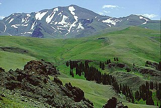
Mount Jefferson is the highest mountain in both the Toquima Range and Nye County in Nevada, United States. It is the sixth highest mountain in the state. As the high point of a range which is well separated from other ranges by low basins, Mount Jefferson has a high topographic prominence of 5,861 feet (1,786 m). This makes it the most prominent peak in Nye County and the third most prominent peak in Nevada. For similar reasons, it is also the highest mountain for over 90 miles in all directions. It is located about 50 miles (80 km) northeast of the county seat of Tonopah within the Alta Toquima Wilderness of the Humboldt-Toiyabe National Forest, near the smaller towns of Carvers and Round Mountain. Three distinct summits are located on a broad area of subalpine tundra: North Summit rises to 11,820 feet (3,603 m), Middle Summit to 11,692 feet (3,564 m), and South Summit to 11,949 feet (3,642 m). During the Pleistocene, alpine glaciers eroded several cirques east of the summit plateau.
Mount Isolation is a mountain located in Coos County, New Hampshire. The mountain is part of the Presidential Range of the White Mountains. Mount Isolation is the highest peak on the Montalban Ridge which extends south from Boott Spur.

Mount Baldy is an extinct stratovolcano in eastern Arizona in the United States. With a summit elevation of 11,409 feet (3,477 m), the peak of Mount Baldy rises above the tree line and is left largely bare of vegetation, lending the mountain its current name. The Mount Baldy Wilderness occupies the eastern slope of the mountain and is managed by the Apache-Sitgreaves National Forest.

Eagle Peak is located in the Warner Mountains in Modoc County, California, United States. The area is protected in the South Warner Wilderness on the Modoc National Forest. The summit is the highest point in the Warner Mountains and Modoc County. Much of the precipitation that falls on Eagle Peak is snow due to the high elevation of the mountain.

Clark Peak is the highest summit of the Medicine Bow Mountains range of the Rocky Mountains of North America. The prominent 12,960-foot (3,950 m) peak is located in the Rawah Wilderness of Routt National Forest, 6.3 miles (10.1 km) north-northwest of Cameron Pass, Colorado, United States, on the drainage divide between Jackson and Larimer counties. Clark Peak is the highest point of Jackson County and the entire drainage basin of the North Platte River.

James Peak is a high mountain summit in the Front Range of the Rocky Mountains of North America. The 13,294 foot thirteener is located on the Continental Divide in the James Peak Wilderness of Arapaho National Forest and Roosevelt National Forest, 5.2 miles (8.4 km) east-southeast of the Town of Winter Park, Colorado, United States. The summit is the tripoint of Clear Creek, Gilpin, and Grand counties. The peak is the highest point in Gilpin County and the second-highest in the James Peak Wilderness.
Flat Top Mountain is the highest summit of the Flat Tops in the Rocky Mountains of North America. The prominent 12,361-foot (3,768 m) peak is located in the Flat Tops Wilderness, 19.1 miles (30.7 km) south-southwest of the Town of Oak Creek, Colorado, United States, on the drainage divide between Routt National Forest and White River National Forest. The summit of Flat Top Mountain is the highest point in Garfield County, Colorado.

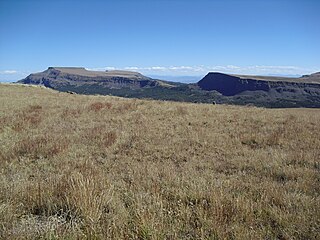
The La Garita Wilderness is a U.S. Wilderness Area located in the La Garita Mountains of southern Colorado. The 129,626-acre (524.58 km2) wilderness established in 1964 in Gunnison and Rio Grande National Forests includes segments of the Colorado Trail and the Continental Divide Trail. At 14,014 feet (4,271 m), San Luis Peak is the highest point in the wilderness area.
Mount Zirkel is the highest summit of the Park Range of the Rocky Mountains of North America. The prominent 12,185-foot (3,714 m) peak is located in the Mount Zirkel Wilderness of Routt National Forest, 25.9 miles (41.7 km) north-northeast of the City of Steamboat Springs, Colorado, United States, on the Continental Divide between Jackson and Routt counties. Mount Zirkel was named in honor of German geologist Ferdinand Zirkel.
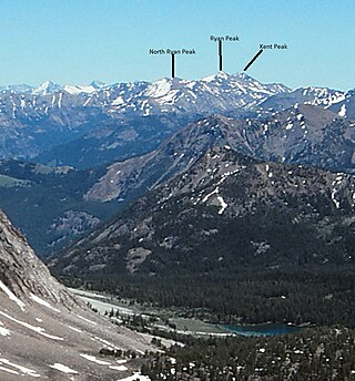
Ryan Peak, at 11,714 feet (3,570 m) above sea level is the highest peak in the Boulder Mountains of Idaho. Located in Custer County, Ryan Peak is about 0.5 miles (800 m) north of the Blaine County border. The peak is also on the border of Sawtooth National Recreation Area and Salmon-Challis National Forest and partially within the Hemingway–Boulders Wilderness.

Mount Powell is the highest summit of the Gore Range in the Rocky Mountains of North America. The prominent 13,586-foot (4,141 m) thirteener is located in the Eagles Nest Wilderness, 8.5 miles (13.7 km) north by east of the Town of Vail, Colorado, United States, along the drainage divide separating White River National Forest and Eagle County from Arapaho National Forest and Summit County. Mount Powell was named in honor of John Wesley Powell who climbed to the summit in 1868.

