Esmeralda County, Nevada

Last updated

Esmeralda County
Esmeralda County, Nevada courthouse.jpg
Esmeralda County, Nevada seal.png
Map of Nevada highlighting Esmeralda County.svg
Location within the U.S. state of Nevada
Nevada in United States.svg
Nevada's location within the U.S.
Coordinates: 37°47′05″N117°37′57″W / 37.7847°N 117.63237°W / 37.7847; -117.63237
CountryFlag of the United States.svg United States
StateFlag of Nevada.svg  Nevada
FoundedNovember 25, 1861
Named for Emerald
Seat Goldfield
Largest community Dyer
Area
  Total3,589 sq mi (9,300 km2)
  Land3,582 sq mi (9,280 km2)
  Water7.2 sq mi (19 km2)  0.2%
Population
 (2020)
  Total729
  Density0.20/sq mi (0.078/km2)
Time zone UTC−8 (Pacific)
  Summer (DST) UTC−7 (PDT)
Congressional district 4th
Website www.accessesmeralda.com
Southern Nevada Consolidated Telephone-Telegraph Company Building, in the Goldfield Historic District. Southern Nevada Consolidated Telephone-Telegraph Company Building, Goldfield, Nevada.jpg
Southern Nevada Consolidated Telephone-Telegraph Company Building, in the Goldfield Historic District.

Esmeralda County is a county in the southwestern portion of the U.S. state of Nevada. As of the 2020 census, the population was 729, [1] making it the least populous county in Nevada, and the 20th least populous county in the United States. Esmeralda County does not have any incorporated communities. Its county seat is the town of Goldfield. [2]

Contents

Its 2000 census population density of 0.2706 inhabitants per square mile (0.1045/km2) was the second-lowest of any county in the contiguous United States (above Loving County, Texas). Its school district does not have a high school, so students in grades 9–12 go to school in Tonopah, in the Nye County School District.

Most residents live in Goldfield or in the town of Dyer in Fish Lake Valley, near the California border. Esmeralda is the only Nevada county in the Los Angeles TV market (or any California market) as defined by The Nielsen Corporation. [3]

History

Esmeralda County is one of the original counties in Nevada, established on November 25, 1861. [4] When it was organized, it comprised the part of the Nevada Territory south of the 39th parallel and east of Mason Valley. [5] Esmeralda is the Spanish and Portuguese word for "emerald". An early California miner from San Jose, James Manning Cory, named the Esmeralda Mining District after Esmeralda the Romani dancer from The Hunchback of Notre-Dame . [6]

Just after the organization of Esmeralda County, the vast majority of the land area had yet to be explored. John C. Frémont was one of the few people who had explored parts of the county. He had crossed Big Smoky Valley in 1845. Also, Aurora and its northern corridor had been encountered. In 1862 and 1863, the area along the Reese River was explored during the Reese River excitement. The event resulted in the establishment of three mining districts in the Toiyabe Range, namely Marysville, Twin River, and Washington, and the establishment of a number of settlements and ranches in Esmeralda County. Explorers pursued south and explored the Shoshone Mountains. The mining district Union was organized after silver was found in 1863 and the settlement of Ione was founded there. [5]

The total area of Esmeralda County more than halved as Nye County was organized on February 16, 1864, entirely out of land that used to be part of Esmeralda County. [5] Esmeralda has had three county seats: Aurora until 1883, Hawthorne from 1883 to 1907 and finally Goldfield. At one point, due to the disputed border with California, Aurora was simultaneously the county seat of both Mono County, California and Esmeralda County. Samuel Clemens (Mark Twain) wrote about his time as a miner in the Esmeralda District in his book Roughing It .

Esmeralda grew from a gold mining boom in the first years of the 20th century. The mines were largely tapped out by the end of the 1910s and the economy and population declined afterwards.

Geography

Aerial view of Fish Lake Valley, Nevada-California Border. View is generally to the northeast, towards the Silver Peak Range. Fish Lake Valley, Nevada-California Border (15083196013).jpg
Aerial view of Fish Lake Valley, Nevada-California Border. View is generally to the northeast, towards the Silver Peak Range.

According to the U.S. Census Bureau, the county has a total area of 3,589 square miles (9,300 km2), of which 3,582 square miles (9,280 km2) is land and 7.2 square miles (19 km2) (0.2%) is water. [7] It is the fourth-smallest county in Nevada by area. A very small part of Death Valley National Park lies in its southeast corner.

The county is dominated by the Silver Peak and Monte Cristo mountain ranges. Mountains in the county include:

Highways

Adjacent counties

Boundary Peak, the highest point in both Esmeralda County and the state of Nevada, is in the Inyo National Forest Boundary Peak Nevada USA.jpg
Boundary Peak, the highest point in both Esmeralda County and the state of Nevada, is in the Inyo National Forest

National protected areas

Demographics

Historical population
CensusPop.Note
1870 1,553
1880 3,220107.3%
1890 2,148−33.3%
1900 1,972−8.2%
1910 9,369375.1%
1920 2,410−74.3%
1930 1,077−55.3%
1940 1,55444.3%
1950 614−60.5%
1960 6190.8%
1970 6291.6%
1980 77723.5%
1990 1,34473.0%
2000 971−27.8%
2010 783−19.4%
2020 729−6.9%
2023 (est.)736 [8] 1.0%
U.S. Decennial Census [9]
1790-1960 [10] 1900-1990 [11]
1990-2000 [12] 2010-2020 [1]

2000 census

At the 2000 census there were 971 people, 455 households, and 259 families living in the county. The population density was 0 people per square mile (0 people/km2). There were 833 housing units at an average density of 0 per square mile (0/km2). The racial makeup of the county was 81.98% White, 0.10% Black or African American, 5.15% Native American, 0.21% Pacific Islander, 7.62% from other races, and 4.94% from two or more races. 10.20% of the population were Hispanic or Latino of any race. [13] Of the 455 households 21.10% had children under the age of 18 living with them, 46.40% were married couples living together, 6.40% had a female householder with no husband present, and 42.90% were non-families. 36.00% of households were one person and 13.20% were one person aged 65 or older. The average household size was 2.12 and the average family size was 2.79.

The age distribution was 20.50% under the age of 18, 6.00% from 18 to 24, 23.40% from 25 to 44, 33.00% from 45 to 64, and 17.20% 65 or older. The median age was 45 years. For every 100 females, there were 123.70 males. For every 100 females age 18 and over, there were 118.70 males.

The median household income was $33,203 and the median family income was $40,917. Males had a median income of $39,327 versus $25,469 for females. The per capita income for the county was $18,971. 15.30% of the population and 7.50% of families were below the poverty line. Out of the total people living in poverty, 9.70% are under the age of 18 and 11.40% are 65 or older.

2010 census

At the 2010 census, there were 783 people, 389 households, and 213 families living in the county. [14] The population density was 0.2 inhabitants per square mile (0.077/km2). There were 850 housing units at an average density of 0.2 per square mile (0.077/km2). [15] The racial makeup of the county was 84.4% white, 4.2% American Indian, 0.4% Asian, 6.6% from other races, and 4.3% from two or more races. Those of Hispanic or Latino origin made up 15.3% of the population. [14] In terms of ancestry, 26.7% were German, 18.6% were English, 14.0% were American, 13.8% were Irish, and 8.7% were Swedish. [16]

Wild Horse in Fish Lake Valley, 2013. Wild Horse Fish Lake Valley (19952902266).jpg
Wild Horse in Fish Lake Valley, 2013.

Of the 389 households, 18.3% had children under the age of 18 living with them, 43.4% were married couples living together, 5.9% had a female householder with no husband present, 45.2% were non-families, and 40.6% of households were made up of individuals. The average household size was 2.01 and the average family size was 2.67. The median age was 52.9 years. [14]

The median household income was $39,712 and the median family income was $57,292. Males had a median income of $41,023 versus $27,019 for females. The per capita income for the county was $34,571. About 6.7% of families and 11.2% of the population were below the poverty line, including 9.8% of those under age 18 and 9.4% of those age 65 or over. [17]

Law and government

The county seat of Esmeralda County is Goldfield since May 1, 1907. The courthouse was opened on May 1, 1908, and has been in continuous use since then. Currently, the Offices of the Assessor, Auditor/Recorder, District Attorney, Sheriff/Jail, Justice of the Peace, Treasurer, District Court, and Commissioner are located in the building.

Politics

United States presidential election results for Esmeralda County, Nevada [18]
Year Republican Democratic Third party
No.%No.%No.%
2020 40082.14%7415.20%132.67%
2016 32977.78%6515.37%296.86%
2012 31772.87%9221.15%265.98%
2008 30369.02%10423.69%327.29%
2004 36776.30%9920.58%153.12%
2000 33367.82%11623.63%428.55%
1996 27750.73%14025.64%12923.63%
1992 22137.84%11820.21%24541.95%
1988 38068.84%14325.91%295.25%
1984 45370.02%15824.42%365.56%
1980 31166.31%11023.45%4810.23%
1976 18143.51%21451.44%215.05%
1972 27368.25%12731.75%00.00%
1968 13839.09%11833.43%9727.48%
1964 13141.19%18758.81%00.00%
1960 15642.05%21557.95%00.00%
1956 16456.94%12443.06%00.00%
1952 17455.59%13944.41%00.00%
1948 16444.93%18350.14%184.93%
1944 15040.21%22359.79%00.00%
1940 29231.36%63968.64%00.00%
1936 15621.61%56678.39%00.00%
1932 14725.65%42674.35%00.00%
1928 30547.21%34152.79%00.00%
1924 24133.20%15020.66%33546.14%
1920 46649.57%34736.91%12713.51%
1916 70931.08%1,13549.76%43719.16%
1912 25213.81%71339.07%86047.12%
1908 2,20838.17%2,78748.18%78913.64%
1904 49042.20%38032.73%29125.06%

Education

The Esmeralda County School District has three elementary schools that currently serve approximately 90 students.

As of 2022 it sends its high school students to Tonopah High School of Nye County School District. [19]

The county is in the service area of Great Basin College. [20]

Communities

An abandoned building in Palmetto, an Esmeralda County ghost town Palmetto, Nevada ghost town.jpg
An abandoned building in Palmetto, an Esmeralda County ghost town

Census-designated places

Ghost towns

See also

Related Research Articles

<span class="mw-page-title-main">Inyo County, California</span> County in California, United States

Inyo County is a county in the eastern central part of the U.S. state of California, located between the Sierra Nevada and the state of Nevada. In the 2020 census, the population was 19,016. The county seat is Independence. Inyo County is on the east side of the Sierra Nevada and southeast of Yosemite National Park in Central California. It contains the Owens River Valley; it is flanked to the west by the Sierra Nevada and to the east by the White Mountains and the Inyo Mountains. With an area of 10,192 square miles (26,400 km2), Inyo is the second-largest county by area in California, after San Bernardino County. Almost one-half of that area is within Death Valley National Park. However, with a population density of 1.8 people per square mile, it also has the second-lowest population density in California, after Alpine County.

<span class="mw-page-title-main">Mono County, California</span> County in California, United States

Mono County is a county located in the east central portion of the U.S. state of California. As of the 2020 census, the population was 13,195, making it the fourth-least populous county in California. The county seat is Bridgeport. The county is located east of the Sierra Nevada between Yosemite National Park and Nevada. The only incorporated town in the county is Mammoth Lakes, which is located at the foot of Mammoth Mountain. Other locations, such as June Lake, are also famous as skiing and fishing resorts. Located in the middle of the county is Mono Lake, a vital habitat for millions of migratory and nesting birds. The lake is located in a wild natural setting, with pinnacles of tufa arising out of the salty and alkaline lake. Also located in Mono County is Bodie, the official state gold rush ghost town, which is now a California State Historic Park.

<span class="mw-page-title-main">Churchill County, Nevada</span> County in Nevada, United States

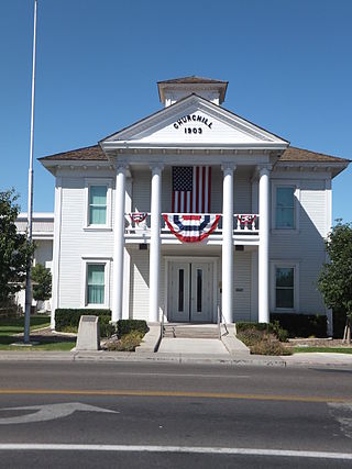
Churchill County is a county in the western U.S. state of Nevada. As of the 2020 census, the population was 25,516. Its county seat is Fallon. Named for Mexican–American War hero brevet Brigadier General Sylvester Churchill, the county was formed in 1861. Churchill County comprises the Fallon, NV Micropolitan Statistical Area. It is in northwestern Nevada. Churchill County is noteworthy in that it owns and operates the local telephone carrier, Churchill County Communications.

<span class="mw-page-title-main">Mohave County, Arizona</span> County in Arizona, United States

Mohave County is in the northwestern corner of the U.S. state of Arizona. As of the 2020 census, its population was 213,267. The county seat is Kingman, and the largest city is Lake Havasu City. It is the fifth largest county in the United States.

<span class="mw-page-title-main">Douglas County, Nevada</span> County in Nevada, United States

Douglas County is a county in the northwestern part of the U.S. state of Nevada. As of the 2020 census, the population was 49,488. Its county seat is Minden. Douglas County comprises the Gardnerville Ranchos, NV Micropolitan Statistical Area, which is also included in the Reno–Carson City–Fernley, NV Combined Statistical Area.

<span class="mw-page-title-main">White Pine County, Nevada</span> County in Nevada, United States

White Pine County is a largely rural, mountain county along the central eastern boundary of the U.S. state of Nevada. As of the 2020 census, the population was 9,080. Its county seat is Ely. The name "(Rocky Mountain) white pine" is an old name for the limber pine, a common tree in the county's mountains.

<span class="mw-page-title-main">Washoe County, Nevada</span> County in Nevada, United States

Washoe County is a county in the U.S. state of Nevada. As of the 2020 census, the population was 486,492, making it Nevada's second-most populous county. Its county seat is Reno. Washoe County is included in the Reno, NV Metropolitan Statistical Area.

<span class="mw-page-title-main">Pershing County, Nevada</span> County in Nevada, United States

Pershing County is a county in the U.S. state of Nevada. As of the 2020 census, the population was 6,650. Its county seat is Lovelock. The county was named after army general John J. Pershing (1860–1948). It was formed from Humboldt County in 1919, and the last county to be established in Nevada. The Black Rock Desert, location for the annual Burning Man event, is partially in the county. The county is listed as Nevada Historical Marker 17. The marker is at the courthouse in Lovelock.

<span class="mw-page-title-main">Nye County, Nevada</span> County in Nevada, United States

Nye County is a county in the U.S. state of Nevada. As of the 2020 census, the population was 51,591. Its county seat is Tonopah. At 18,159 square miles (47,030 km2), Nye is Nevada's largest county by area and the third-largest county in the contiguous United States, behind Coconino County of Arizona and San Bernardino County of California.

<span class="mw-page-title-main">Mineral County, Nevada</span> County in Nevada, United States

Mineral County is a county located in the U.S. state of Nevada. As of the 2020 census, the population was 4,554, making it the fifth-least populous county in Nevada. Its county seat is Hawthorne.

<span class="mw-page-title-main">Lyon County, Nevada</span> County in Nevada, United States

Lyon County is a county in the U.S. state of Nevada. As of the 2020 census, the population was 59,235. Lyon County comprises the Fernley, NV Micropolitan Statistical Area which is part of the Reno-Carson City-Fernley, NV Combined Statistical Area.

<span class="mw-page-title-main">Lincoln County, Nevada</span> County in Nevada, United States

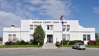
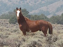
Lincoln County is a county in the U.S. state of Nevada. As of the 2020 census, the population was 4,499, making it the fourth-least populous county in Nevada. Its county seat is Pioche. Like many counties in Nevada, it is dry and sparsely populated, though notable for containing the Area 51 government Air Force base.

<span class="mw-page-title-main">Lander County, Nevada</span> County in Nevada, United States

Lander County is a county in the U.S. state of Nevada. As of the 2020 census, the population was 5,734. Its county seat is Battle Mountain.

<span class="mw-page-title-main">Eureka County, Nevada</span> County in Nevada, United States

Eureka County is a county in the U.S. state of Nevada. As of the 2020 census, the population was 1,855, making it the second-least populous county in Nevada. Its county seat is Eureka.

<span class="mw-page-title-main">Elko County, Nevada</span> County in Nevada, United States

Elko County is a county in the northeastern corner of Nevada, United States. As of the 2020 census, the population was 53,702. Its county seat is Elko. The county was established on March 5, 1869, from Lander County.

<span class="mw-page-title-main">Galt, Iowa</span> City in Iowa, United States

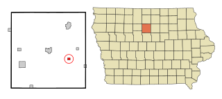
Galt is a city in Wright County, Iowa, United States. The population was 26 at the time of the 2020 census.

<span class="mw-page-title-main">Aurora, Minnesota</span> City in Minnesota, United States

Aurora is a city in Saint Louis County, Minnesota, United States. The population was 1,678 at the 2020 census.

<span class="mw-page-title-main">Hawthorne, Nevada</span> CDP in Nevada, United States

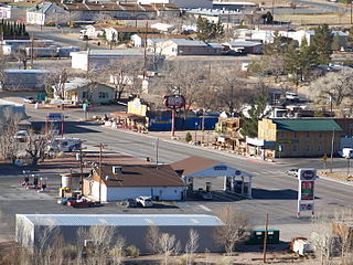
Hawthorne is a census-designated place (CDP) in Mineral County, Nevada, United States. At the 2010 census, the population was 3,269, a decrease since the 2000 census, when it was 3,311. It is the county seat of Mineral County. The nearby Hawthorne Army Depot is the primary economic base of the town.

<span class="mw-page-title-main">Beatty, Nevada</span> Unincorporated town in Nevada, United States

Beatty is an unincorporated town along the Amargosa River in Nye County, Nevada, United States. U.S. Route 95 runs through the town, which lies between Tonopah, about 90 miles (140 km) to the north and Las Vegas, about 120 miles (190 km) to the southeast. State Route 374 connects Beatty to Death Valley National Park, about 8 miles (13 km) to the west.

<span class="mw-page-title-main">Gabbs, Nevada</span> Unincorporated town in the State of Nevada, United States

Gabbs is an unincorporated town in Nye County, Nevada, United States. The population was 269 at the 2010 census. Located in northern Nye County, it is part of the Greater Las Vegas, making it at 321 miles (517 km) the most distant community from Las Vegas in the Las Vegas–Henderson combined statistical area.

References

  1. 1 2 "State & County QuickFacts". United States Census Bureau. Retrieved April 4, 2022.
  2. "County Explorer". National Association of Counties. Retrieved June 7, 2011.
  3. Nielsen DMA—Designated Market Area Regions 2018–2019, The Nielsen Company, 2018.
  4. "History of Esmeralda County". History of Nevada. Thompson and West. 1881. pp. 401–425.
  5. 1 2 3 Thompson; West (1881). History of Nevada. Oakland, California: Thompson and West. pp.  512 and 513. Retrieved February 7, 2016.
  6. Paul F. Starrs, "Esmeralda County, Nevada: Empty Land? Poor Land? Fair Land? Masters thesis, Geography, University of California, Berkeley, 1984
  7. "2010 Census Gazetteer Files". United States Census Bureau. August 22, 2012. Retrieved December 20, 2014.
  8. "Annual Estimates of the Resident Population for Counties: April 1, 2020 to July 1, 2023". United States Census Bureau. Retrieved March 26, 2024.
  9. "U.S. Decennial Census". United States Census Bureau. Retrieved December 20, 2014.
  10. "Historical Census Browser". University of Virginia Library. Retrieved December 20, 2014.
  11. "Population of Counties by Decennial Census: 1900 to 1990". United States Census Bureau. Retrieved December 20, 2014.
  12. "Census 2000 PHC-T-4. Ranking Tables for Counties: 1990 and 2000" (PDF). United States Census Bureau. Archived (PDF) from the original on March 27, 2010. Retrieved December 20, 2014.
  13. "U.S. Census website". United States Census Bureau . Retrieved January 31, 2008.
  14. 1 2 3 "DP-1 Profile of General Population and Housing Characteristics: 2010 Demographic Profile Data". United States Census Bureau. Archived from the original on February 13, 2020. Retrieved January 21, 2016.
  15. "Population, Housing Units, Area, and Density: 2010 - County". United States Census Bureau. Archived from the original on February 13, 2020. Retrieved January 21, 2016.
  16. "DP02 SELECTED SOCIAL CHARACTERISTICS IN THE UNITED STATES – 2006-2010 American Community Survey 5-Year Estimates". United States Census Bureau. Archived from the original on February 13, 2020. Retrieved January 21, 2016.
  17. "DP03 SELECTED ECONOMIC CHARACTERISTICS – 2006-2010 American Community Survey 5-Year Estimates". United States Census Bureau. Archived from the original on February 13, 2020. Retrieved January 21, 2016.
  18. Leip, David. "Dave Leip's Atlas of U.S. Presidential Elections". uselectionatlas.org. Retrieved April 12, 2018.
  19. "Education". Esmeralda County, Nevada. Retrieved July 17, 2022.
  20. "Data and Information". Great Basin College . Retrieved March 10, 2024.

37°47′05″N117°37′57″W / 37.7847°N 117.63237°W / 37.7847; -117.63237