Esperanza Field

Last updated
Esperanza Airport
Peñuela Airport
Summary
Airport type Public
Serves Valverde Province,
Dominican Republic
Location Esperanza / Mao
Elevation  AMSL 100 m / 328 ft
Coordinates 19°35′03″N070°57′32″W / 19.58417°N 70.95889°W / 19.58417; -70.95889
Runways
Direction Length Surface
m ft
600 1,969 Gravel
Source: AIP Republica Dominicana [1]

Esperanza Airport or Peñuela Airport( ICAO : MDES) [1] is located in Esperanza, a municipality of the Valverde province in the Dominican Republic. It is mostly used for private aviation, and in cases for some charters from cities within the country.

ICAO airport code four-letter code designating many airports around the world

The ICAOairport code or location indicator is a four-letter code designating aerodromes around the world. These codes, as defined by the International Civil Aviation Organization and published in ICAO Document 7910: Location Indicators, are used by air traffic control and airline operations such as flight planning.

Esperanza, Dominican Republic Place in Valverde, Dominican Republic

Esperanza is a municipality (municipio) of the Valverde province in the Dominican Republic. Within the municipality there are four municipal districts : Boca de Mao, Jicomé, Maizal and Paradero.

Valverde Province Province in Dominican Republic

Valverde is a province of the Dominican Republic. It was split from Santiago Province in 1959. It is in the northwestern part of the country. Its capital city is Santa Cruz de Mao.

Contents

Facilities

Peñuela Airport resides at an elevation of 100 metres (328 ft) above mean sea level. It has one runway designated 09/27 with a gravel surface measuring 600 by 13 metres (1,969 ft × 43 ft). [1]

Elevation Height of a geographic location above a fixed reference point

The elevation of a geographic location is its height above or below a fixed reference point, most commonly a reference geoid, a mathematical model of the Earth's sea level as an equipotential gravitational surface . The term elevation is mainly used when referring to points on the Earth's surface, while altitude or geopotential height is used for points above the surface, such as an aircraft in flight or a spacecraft in orbit, and depth is used for points below the surface.

Runway Area of surface used by aircraft to takeoff from and land on

According to the International Civil Aviation Organization (ICAO), a runway is a "defined rectangular area on a land aerodrome prepared for the landing and takeoff of aircraft". Runways may be a man-made surface or a natural surface.

Gravel mix of crumbled stone (grain size range = 2-63 mm according to ISO 14688)

Gravel is a loose aggregation of rock fragments. Gravel is classified by particle size range and includes size classes from granule- to boulder-sized fragments. In the Udden-Wentworth scale gravel is categorized into granular gravel and pebble gravel. ISO 14688 grades gravels as fine, medium, and coarse with ranges 2 mm to 6.3 mm to 20 mm to 63 mm. One cubic metre of gravel typically weighs about 1,800 kg.

See also

Related Research Articles

Big Creek Airport (Belize)

Big Creek Airport is an airport serving Big Creek, a sea port in the Toledo District of Belize.

Rosita Airport

Rosita Airport is a private airport serving Rosita, Nicaragua. The runway is 3 kilometres (1.9 mi) south of town.

Gbadolite Airport

Gbadolite Airport is an airport serving Gbadolite, the capital of the Nord-Ubangi Province in the Democratic Republic of the Congo. The airport is at the village of Moanda, 6 kilometres (3.7 mi) southwest of Gbadolite.

Constanza Airport airport in the Dominican Republic

Constanza National Airport is an airport for domestic flights serving Constanza, a town in the La Vega Province of the Dominican Republic.

Osvaldo Virgil Airport airport in the Dominican Republic

Osvaldo Virgil National Airport serves the province of Monte Cristi on the north coast of the Dominican Republic. This airport was opened in 2006 for tourism with flights from other Dominican airports. The runway is just north of the city.

Dajabón Airport airport

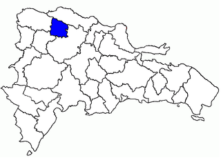
Dajabón National Airport is an airport that serves Dajabón, the capital of Dajabón Province in the western Dominican Republic. The airport is 4 kilometres (2.5 mi) east of the border with Haiti.

Cueva Las Maravillas Airport airport in the Dominican Republic

Cueva Las Maravillas Airport is an airport 13 kilometres (8 mi) east of San Pedro de Macorís, capital of the San Pedro de Macorís Province in the Dominican Republic. The airport was opened on February 7, 2008.

Azua Dominican Field airport in the Dominican Republic

Azua Dominica Airport is an airport 2 kilometres (1.2 mi) south of the city of Azua in the Azua Province of the Dominican Republic. It is an old airport that is used only for the emergency landing of domestic flights. This airport has never had regularly scheduled flights, although some airlines have operated charter or tourist flights here.

Angelina Field airport in the Dominican Republic

Angelina Airport is an agricultural airport 10 kilometres (6.2 mi) northwest of Cotuí, at the small town of El Pescozón in the Sánchez Ramírez Province of the Dominican Republic.

Enriquillo Field airport in the Dominican Republic

Juancho Enriquillo Airport is an agricultural airstrip 4 kilometres (2.5 mi) southwest of Enriquillo, a Caribbean coastal town in the Barahona Province of the Dominican Republic.

Baigua Field airport in the Dominican Republic

Baigua Airport was an agricultural airstrip near the hamlet of Baigue, in the La Altagracia Province of the Dominican Republic. Baigue is 7 kilometres (4.3 mi) southeast of Higüey.

Walterio Field airport in the Dominican Republic

Walterio Airport is a rural airport 10 kilometres (6.2 mi) south of the coastal city of Monte Cristi, Dominican Republic. It serves private aviation and air sports. Now with the Osvaldo Virgil Airport replacing most of its operations, this airport has been reverted as only a runway.

Los Montones Field airport in the Dominican Republic

Los Montones Airport is an airstrip 11 kilometres (7 mi) north of San Cristóbal, Dominican Republic.

Caucayá Airport

Caucayá Airport is an airport serving the river town of Puerto Leguízamo in the Putumayo Department of Colombia. Puerto Leguízamo is on the Putumayo River, locally the border with Peru.

San Isidro Air Base airport in the Dominican Republic

The Base Aérea de San Isidro or San Isidro Air Base became operational on March 23, 1953 and is located 25 km east of Santo Domingo. It was named Base Aérea Trujillo until 1961, when the name was changed to San Isidro. Most of the units, aircraft, and helicopters of the Dominican Air Force are based there.

Colonia Airport airport

Colonia International Airport is a general aviation airport serving Colonia del Sacramento, capital of the Colonia Department of Uruguay.

Mona Airport

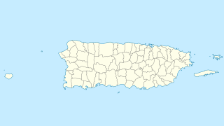
Mona Airport is an airstrip on Mona Island, the third largest island of Puerto Rico. Private and commercial flights require a permit for use of the landing strip. The permit can only be acquired through the Puerto Rico Department of Natural and Environmental Resources. The airport is also available to planes for emergency purposes.

El Mirador Airport, is an airport just southeast of Puerto Varas, a city in the Los Lagos Region of Chile. Puerto Varas is on the southwest shore of Llanquihue Lake.

La Esperanza Airport, Colón airport in Honduras

La Esperanza Airport is an airport serving a number of agricultural villages and towns in western Colón Department, Honduras. The largest nearby towns are Sonaguera (13 km) and Sabá (17 km).

Sucúa Airport

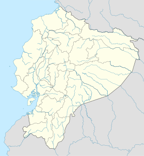
Sucúa Airport is an airport serving the town of Sucúa in Morona-Santiago Province, Ecuador.

References

  1. 1 2 3 "AIP-Republica Dominicana: AD 1.3-11" ( PDF, 129  KB ). AIS-Republica Dominicana. Effective 17 January 2008.Check date values in: |date= (help)

The Aviation Safety Network (ASN) is a website that keeps track of aviation accidents, incidents, and hijackings. Their database contains details of over 10,700 reports. The ASN includes an aviation database with aviation investigations, news, photos, and statistics.