
Fayette County is a county in the Commonwealth of Pennsylvania. It is located in southwestern Pennsylvania, adjacent to Maryland and West Virginia. As of the 2020 census, the population was 128,804. Its county seat is Uniontown. The county was created on September 26, 1783, from part of Westmoreland County and named after the Marquis de Lafayette.

North Fayette Township is a township in Allegheny County, Pennsylvania, United States. The township is a suburb of Pittsburgh. The population was 13,680 at the 2010 census. The township has been home to the Park Lane Office center since 1989.

South Fayette Township is a township in Allegheny County, Pennsylvania, United States. The population was 14,416 at the 2010 census.

Brownsville is a borough in Fayette County, Pennsylvania, United States, first settled in 1785 as the site of a trading post a few years after the defeat of the Iroquois enabled a resumption of westward migration after the Revolutionary War. The trading post soon became a tavern and inn and was receiving emigrants heading west, as it was located above the cut bank overlooking the first ford that could be reached to those descending from the Allegheny Mountains. Brownsville is located 40 miles (64 km) south of Pittsburgh along the east bank of the Monongahela River.

Henry Clay Township is a township in Fayette County, Pennsylvania, United States. The population was 1,765 at the 2020 census. The township was created June 9, 1824, from the eastern portion of Wharton Township. It is named for 19th-century American statesman Henry Clay. The northwestern corner of its territory was used to create Stewart Township on November 17, 1855. It is served by the Uniontown Area School District.
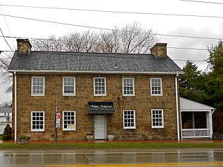
Hopwood is a census-designated place (CDP) in Fayette County, Pennsylvania, United States. The population was 2,090 at the 2010 census, up from 2,006 at the 2000 census. It is located in North Union and South Union townships. The village was named after John Hopwood.
North Union Township is a township in Fayette County, Pennsylvania, United States. The population was 11,826 at the 2020 census, a decline from the figure of 12,728 tabulated in 2010. The Laurel Highlands School District serves the township.
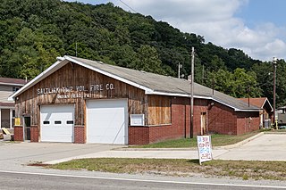
Saltlick Township is a township that is located in Fayette County, Pennsylvania, United States. The population was 3,037 according to the 2020 United States Census, a decline of twelve percent from the 2010 census, and eighteen percent from the 2000 census. It is served by the Connellsville Area School District.
South Union Township is a township in Fayette County, Pennsylvania, United States. The population was 10,895 at the 2020 census, an increase over the figure of 10,681 tabulated in 2010.

Stewart Township is a township in Fayette County, Pennsylvania, United States. It is part of the Pittsburgh Metro Area. The population was 619 at the 2020 census.

Wharton Township is a township in Fayette County, Pennsylvania, United States. The population was 3,372 at the 2020 census, down from 3,575 at the 2010 census. The Uniontown Area School District serves the region.

Salisbury Township is a township in Lehigh County, Pennsylvania. The township's population was 13,505 at the 2010 census. The township borders Allentown, Pennsylvania's third-largest city, Bethlehem, and Emmaus, in the Lehigh Valley, which had a population of 861,899 and was the 68th-most populous metropolitan area in the U.S. as of the 2020 census.

Seven Springs is a borough in Somerset and Fayette counties in the U.S. state of Pennsylvania. The Fayette County portion of the borough and resort are part of the Pittsburgh metropolitan area, and the Somerset County portion is part of the Johnstown Metropolitan Area. The population of the borough was 26 as of the 2010 census, compared to 127 at the 2000 census. Fifteen of the residents in 2010 were in Fayette County, and 11 in Somerset County.

The Laurel Highlands is a region in southwestern Pennsylvania made up of Fayette County, Somerset County, and Westmoreland County. It has a population of about 600,000 people.

Fort Necessity National Battlefield is a National Battlefield in Fayette County, Pennsylvania, United States, which preserves the site of the Battle of Fort Necessity. The battle, which took place on July 3, 1754, was an early battle of the French and Indian War, and resulted in the surrender of British colonial forces under Colonel George Washington, to the French and Indians, under Louis Coulon de Villiers.
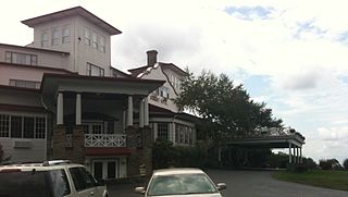
Nemacolin is a four-season resort in Farmington, Fayette County, Pennsylvania. The resort is owned by Maggie Hardy, Owner and CEO of the 84 Lumber Company, and was founded by her father, Joseph Hardy.

U.S. Route 40 enters Pennsylvania at West Alexander. It closely parallels Interstate 70 (I-70) from West Virginia until it reaches Washington, where it follows Jefferson Avenue and Maiden Street.In Washington, US 40 passes to the south of Washington & Jefferson College. Following Maiden Street out of town, the road turns southeast toward the town of California. A short limited access highway in California and West Brownsville provides an approach to the Lane Bane Bridge across the Monongahela River. From here, the road continues southeast to Uniontown.

Joseph A. Hardy Connellsville Airport is a public-use airport located four nautical miles southwest of Connellsville in Dunbar Township, Fayette County, Pennsylvania, United States. It is owned by the Fayette County Airport Authority and serves the south-eastern segment of the Pittsburgh metropolitan area. The airport serves the general aviation community with no scheduled commercial airline service.

Chalk Hill is an unincorporated community and census-designated place in Wharton Township, Fayette County, Pennsylvania, United States. It is located along U.S. Route 40, approximately 8 miles (13 km) southeast of the city of Uniontown. As of the 2010 census, the population was 141.
Deer Lake is an unincorporated community and census-designated place in Wharton Township, Fayette County, Pennsylvania, United States. It is 1 mile (1.6 km) east of Chalkhill and 5 miles (8 km) northwest of Farmington in the Laurel Highlands of southwestern Pennsylvania. As of the 2010 census, the population was 495.


