The Raritan River is a major river of New Jersey. Its watershed drains much of the mountainous area of the central part of the state, emptying into the Raritan Bay on the Atlantic Ocean.
The Rahway River is a river in Essex, Middlesex, and Union Counties, New Jersey, United States, The Rahway, along with the Elizabeth River, Piles Creek, Passaic River, Morses Creek, the Fresh Kills River, has its river mouth at the Arthur Kill.

The Lehigh River is a 109-mile-long (175 km) tributary of the Delaware River in eastern Pennsylvania. The river flows in a generally southward pattern from the Pocono Mountains in Northeastern Pennsylvania through Allentown and much of the Lehigh Valley before joining the Delaware River in Easton.

Merrill Creek Reservoir, located in Harmony Township, New Jersey in central Warren County, New Jersey, is a 650-acre (260 ha) artificial lake designed to hold 15 billion gallons of water that is surrounded by 290 acres (120 ha) of protected woodland and fields. These lands are themselves part of 2,000 acres (8.1 km2) of open spaces.

Lawrence Brook is a tributary of the Raritan River in Middlesex County, New Jersey, in the United States.

The Escanaba River is a 52.2-mile-long (84.0 km) river on the Upper Peninsula of the U.S. state of Michigan.

Bowman Creek is a tributary of the Susquehanna River in Luzerne County and Wyoming County, in Pennsylvania, in the United States. It is approximately 26 miles (42 km) long and flows through Ross Township and Lake Township in Luzerne County and Noxen Township, Monroe Township, and Eaton Township in Wyoming County. The watershed of the creek has an area of 120 square miles (310 km2). The creek is not designated as an impaired waterbody and its pH is close to neutral, although it has experienced some problems with acid rain. It has low concentrations of dissolved solids like calcium. The creek is relatively small in its upper reaches, but by Noxen, its width is 40 to 60 feet. It is also relatively shallow in many reaches. Rock formations in the watershed include the Catskill Formation, the Huntley Mountain Formation, Burgoon Sandstone, the Mauch Chunk Formation, the Pottsville Group, and the Pocono Formation. Soil associations in the creek's watershed include the Wellsboro-Morris-Oquaga association, the Oquaga-Lackawanna-Arnot association, the Mardin-Bath-Volusia association, and the Wyoming-Pope association.
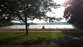
Swartswood State Park is a 3,460-acre (14.0 km2) protected area located in the Swartswood section of Stillwater and Hampton townships in Sussex County, New Jersey, in the United States. Established in 1915 by the state's Forest Park Reservation Commission, it was the first state park established by the state of New Jersey for the purposes of recreation at the state's third-largest freshwater lake. Today, Swartswood State Park is operated and maintained by the New Jersey Division of Parks and Forestry.
The Nipigon River is located in Thunder Bay District in Northwestern Ontario, Canada. The river is about 48 km (30 mi) long and 50 to 200 m wide, and flows from Lake Nipigon to Nipigon Bay on Lake Superior at the community of Red Rock, dropping from an elevation of 260 to 183 m. It is the largest tributary of Lake Superior.

Hopkins Pond is a small pond located at the south foot of Ragged Mountain, in the town of Andover, New Hampshire, United States. It lies at an elevation of 644 feet (196 m). The pond is part of Proctor Academy's 2,500-acre (10 km2) campus in Andover and is jointly managed by Proctor and the New Hampshire Fish and Game Department. The pond area is open to the public for non-motorized boat travel, fishing and hiking.

Lake Sunapee is located within Sullivan County and Merrimack County in western New Hampshire, the United States. It is the fifth-largest lake located entirely in New Hampshire.
Ireland Brook is a tributary of Lawrence Brook in Middlesex County, New Jersey in the United States.
Beaverdam Brook is a tributary of Lawrence Brook in central East Brunswick, New Jersey in the United States.

Davis Run is a tributary of Catawissa Creek in Schuylkill County, Pennsylvania, in the United States. It is approximately 1.2 miles (1.9 km) long. The watershed of the stream has an area of 2.86 square miles (7.4 km2). The stream is considered to be a High-Quality Coldwater Fishery and Class A Wild Trout Waters. Six species of fish inhabit the stream, including brown trout and brook trout. The main rock formations in the stream's watershed are the Mauch Chunk Formation and the Pottsville Formation and the main soils are the Leck Kill soil and the Hezleton soil. The stream has two unnamed tributaries and a lake known as the Pumping Station Reservoir.

Spring Brook is a tributary of the Lackawanna River in Lackawanna County and Luzerne County, in Pennsylvania, in the United States. It is approximately 17 miles (27 km) long and flows through Covington Township, Spring Brook Township, and Moosic in Lackawanna County and Pittston Township in Luzerne County. The watershed of the stream has an area of 57.2 square miles (148 km2). It is designated as a High-Quality Coldwater Fishery and a Migratory Fishery above Interstate 476 and as a Coldwater Fishery and a Migratory Fishery below it. A section is also designated as Class A Wild Trout Waters. The stream's tributaries include Panther Creek, Plank Bridge Creek, Rattlesnake Creek, Green Run, Monument Creek, and Covey Swamp Creek. It has a relatively high level of water quality and is very slightly acidic, with a pH of 6.4 to 6.9.
Rattlesnake Creek is a tributary of Spring Brook in Lackawanna County, Pennsylvania, in the United States. It is approximately 5.0 miles (8.0 km) long and flows through Spring Brook Township. The watershed of the creek has an area of 9.18 square miles (23.8 km2). The creek has one named tributary, which is known as Six Springs Creek. Rattlesnake Creek is inhabited by wild trout and part of it is considered to be Class A Wild Trout Waters. A dammed lake known as Maple Lake is located near its headwaters. The surficial geology in the area mainly consists of Wisconsinan Till and bedrock, with some alluvium, Wisconsinan Ice-Contact Stratified Drift, wetlands, and peat bogs.
Lake Run is a tributary of Roaring Brook in Lackawanna County, Pennsylvania, in the United States. It is approximately 1.6 miles (2.6 km) long and flows through Covington Township. The watershed of the stream has an area of 3.44 square miles (8.9 km2). It has one named tributary, which is known as Emerson Run. Lake Run is considered to be Class A Wild Trout Waters. The surficial geology in its vicinity consists of Wisconsinan Ice-Contact Stratified Drift, Wisconsinan Till, Boulder Colluvium, alluvium, bedrock, sand and gravel pits, fill, wetlands, peat bogs, and a lake.
Rapid Run is a tributary of Buffalo Creek in Centre County and Union County in Pennsylvania, in the United States. It is approximately 14.4 miles (23.2 km) long and flows through Miles Township in Centre County and Hartley Township, Lewis Township, West Buffalo Township, and Buffalo Township in Union County. The watershed of the stream has an area of 18.7 square miles (48 km2). Some streams in the watershed are impacted by nutrients, sediment, E. coli, and thermal radiation and one unnamed tributary is designated as an impaired waterbody. Rapid Run is a freestone mountain stream in the ridge and valley physiographic province. It flows through a lake known as Halfway Lake and also passes through the Rapid Run Gap.

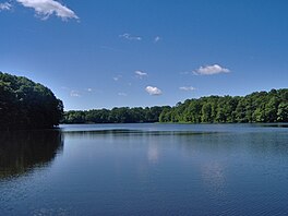
Swartswood Lake is a freshwater lake located in Stillwater and Hampton townships in Sussex County, New Jersey in the United States. The lake is a 520-acre (210 ha) glacial lake that is the third-largest freshwater lake in New Jersey. The lake stretches 3 miles (4.8 km) (north-to-south) and 1 mile (1.6 km) wide ; and has an average depth of 22 feet (6.7 m) with a maximum depth of 42 feet (13 m). The lake is the focus of Swartswood State Park a 3,460-acre (14.0 km2) protected area administered by the New Jersey Division of Parks and Forestry.
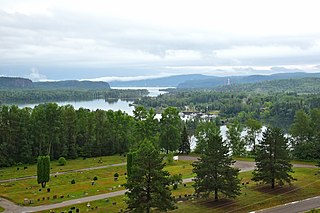
The Belgrade Lakes are a chain of lakes around Belgrade, Maine. The flow sequence is from East Pond to North Pond to Great Pond to Long Pond to Messalonskee Lake and thence via Messalonskee Stream to the Kennebec River at Waterville. The lakes have long been an important resort area for fishing, boating, and swimming; and shoreline development includes residences for individuals employed in the cities of Waterville and Augusta.