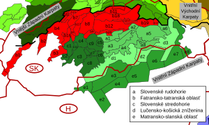
Fatra-Tatra Area

Last updated
Fatra-Tatra
Jahnaci stit over Velke Biele pleso.jpg
Kolový štít and Jahňací štít over Veľké Biele Pleso
Highest point
PeakGerlachovský štít
Elevation 2,655 m (8,711 ft)
Coordinates 49°10′N20°8′E / 49.167°N 20.133°E / 49.167; 20.133 Coordinates: 49°10′N20°8′E / 49.167°N 20.133°E / 49.167; 20.133
Geography
Slovakia relief location map.svg
Red triangle with thick white border.svg
Fatra-Tatra
Location of the Fatra-Tatra Area in Slovakia
CountriesSlovakia, Austria and Poland
Subdivisions Branisko, Choč Mountains, Greater Fatra, Horehronské podolie, Hornád Basin, Kozie chrbty, Lesser Fatra, Little Carpathians, Low Tatras, Považský Inovec, Staré Hory Mountains, Strážov Mountains, Sub-Tatra Basin, Súľov Mountains, Tatras, Tríbeč, Turiec Basin, Upper Nitra Basin, Žilina Basin and Žiar
Parent range Inner Western Carpathians
Extent of the Fatra-Tatra Area (red) in Slovakia Vnitrni Zapadni Karpaty, b.svg
Extent of the Fatra-Tatra Area (red) in Slovakia

The Fatra-Tatra Area (in geomorphology) [1] or the Tatra-Fatra Belt of core mountains (in geology) [2] is a part of the Inner Western Carpathians, a subprovince of the Western Carpathians. Most of the area lies in Slovakia with small parts reaching into Austria and Poland. The highest summit of the whole Carpathians, the Gerlachovský štít at 2,655 m (8,711 ft), lies in the High Tatras range which belongs to this area.

The Fatra-Tatra Area is from the northern side bounded by Pieniny Klippen Belt. Mountains of the area are located in two ranges. The external range consists of Hainburg Hills, Malé Karpaty (Pezinok part), Považský Inovec, Strážovské vrchy, Malá Fatra, Tatras (Western, High and Belianske Tatry). Inner range consists of Tribeč, Žiar, Veľká Fatra, Chočské vrchy, Ďumbier part of Nízke Tatry and massif of Smrekovica in the Branisko. [3] The southern boundary of Area is the Čertovica line, south of which is the Vepor Belt.

The Tatra-Fatra Belt consists of Tatric alpine crystalline basement and its autochthonous sedimentary cover, over which the Subtatric nappes (Fatric and Hronic) were thrust. [4]

The name core mountains is derived from the structural element, resistant crystalline basement rocks, preserved in the core of horsts, often forming the highest peaks of the mountains.

Origin

The basement of the core mountains is formed by the Tatric Unit, which is composed of dominantly hercynian metamorphic and igneous rocks and locally also a sedimentary cover of various thickness. In the Paleozoic clastic and volcanoclastic sediments deposited in the area, but later during Hercynian orogeny, sediments were metamorphosed in the greenschist and amphibolite facies (forming large amount of paragneisses and amphibolites, only locally orthogneisses, phyllites and mica schists). Regional and contact metamorphism was induced also by intrusions of granites, which accompanied the Hercynian collision (generally in the Carboniferous). Basement rocks were later exposed due to erosion and at the end of the Paleozoic affected by marine transgression that lasted till the end of Mesozoic. During this period sedimentary rocks, known as Tatric cover units, deposited. They generally consists of clastic and carbonate rocks.

Schematic cross section through the core mountain:
.mw-parser-output .legend{page-break-inside:avoid;break-inside:avoid-column}.mw-parser-output .legend-color{display:inline-block;min-width:1.25em;height:1.25em;line-height:1.25;margin:1px 0;text-align:center;border:1px solid black;background-color:transparent;color:black}.mw-parser-output .legend-text{}
Cretaceous and Paleogene sedimentary cover
Subtatric Nappes
Tatric cover units
Crystalline basement Jadrove pohorie.png
Schematic cross section through the core mountain:
   Cretaceous and Paleogene sedimentary cover

In the Upper Cretaceous area of Tatric Unit, was affected by Eo-Alpine of Alpine Orogeny, that caused movement of large masses of rocks to the North and Northeast. To the South of the Tatric area a 2 superficial nappes, so called Subtatric Nappes, were detached and thrust over the Tatric. These nappes are generally composed of limestone, marl, dolomite and less by sandstones and slates. The lower nappes is called Krížna Nappe (or the Fatric) and the upper is Choč Nappe (or the Hronic). Krížňa Nappe is dominantly composed of rock, that were formed in the Zliechov basin. It was situated in the Fatric area between the Tatric and Veporic units. Fatric had the same basement as the Veporic unit and is considered as former northern part of Veporic, but later during the thrusting its substratum was consumed and subducted. Surface occurrences of Fatric basement remained only as a remnants in the northern part of Veporic Veľký Bok Unit and few other areas. Choč Nappe, was thrust from the southern area, but its roots were probably consumed entirely, so its paleogeographic position is not exactly known. Choč Nappe is considered as rootless nappe.

After the end of main Eo-Alpine orogenic movement, the area of Western Carpathians was still not so mountainous. In the Paleogene subsidence along the normal faults caused formation of grabens - intra-mountain Inner Carpathian Paleogene Basin and horsts present day mountain ranges. In the Neogene, further orogene movement in the external part of Carpathian arc caused formation of back-arc Pannonian Basin. Northern branches of Pannonian Basin were penetrating the Tatra-Fatra Area and formed inter-mountain basins. Simultaneously with the immersion of the horsts, ongoing and intense erosion is denuding the mountains and supplies the basin with clastic sediments. Among all of the rocks, the most erosion resistant were the crystalline schists and granites of the Tatric. Similar fold and thrust model of origin is known from the other areas of alpine system. In the English terminology, similar model is called Fault-block mountain, it is typical in the area of Basin and Range.

Related Research Articles

Carpathian Mountains Mountain range in Central and Eastern Europe

The Carpathian Mountains or Carpathians are a range of mountains forming an arc throughout Central and Eastern Europe. Roughly 1,500 km (932 mi) long, it is the third-longest European mountain range after the Urals at 2,500 km (1,553 mi) and the Scandinavian Mountains at 1,700 km (1,056 mi). The range stretches from the far eastern Czech Republic (3%) in the northwest through Slovakia (17%), Poland (10%), Hungary (4%), Ukraine (10%), Romania (50%) to Serbia (5%) in the south. The highest range within the Carpathians is known as the Tatra mountains in Slovakia and Poland, where the highest peaks exceed 2,600 m (8,530 ft). The second-highest range is the Southern Carpathians in Romania, where the highest peaks range between 2,500 m (8,202 ft) and 2,550 m (8,366 ft).

The Alps form part of a Cenozoic orogenic belt of mountain chains, called the Alpide belt, that stretches through southern Europe and Asia from the Atlantic all the way to the Himalayas. This belt of mountain chains was formed during the Alpine orogeny. A gap in these mountain chains in central Europe separates the Alps from the Carpathians to the east. Orogeny took place continuously and tectonic subsidence has produced the gaps in between.

Divisions of the Carpathians

Divisions of the Carpathians are a categorization of the Carpathian mountains system.

Nappe A large sheetlike body of rock that has been moved a considerable distance above a thrust fault

In geology, a nappe or thrust sheet is a large sheetlike body of rock that has been moved more than 2 km (1.2 mi) or 5 km (3.1 mi) above a thrust fault from its original position. Nappes form in compressional tectonic settings like continental collision zones or on the overriding plate in active subduction zones. Nappes form when a mass of rock is forced over another rock mass, typically on a low angle fault plane. The resulting structure may include large-scale recumbent folds, shearing along the fault plane, imbricate thrust stacks, fensters and klippe.

Veľká Fatra

Veľká Fatra is a mountain range in the Western Carpathians in Slovakia. The Veľká Fatra lie to the southeast of the better known Malá (Lesser) Fatra mountains and are less developed, as well as being lower.

Helvetic (geology)

The Helvetic zone, Helvetic system or the Helveticum is a geologic subdivision of the Alps. The Helvetic zone crops out mainly in Switzerland, hence the name. Rocks in the Helvetic zone are sedimentary and were originally deposited at the southern margin of the European plate. The Helvetic zone correlates with the French Dauphinois zone, French geologists often prefer the French name but normally this is considered the same thing.

Austroalpine nappes

The Austroalpine nappes are a geological nappe stack in the European Alps. The Alps contain three such stacks, of which the Austroalpine nappes are structurally on top of the other two. The name Austroalpine means Southern Alpine, because these nappes crop out mainly in the Eastern Alps.

Western Carpathians Mountain range along the border between Poland, the Czech Republic, and Slovakia

The Western Carpathians are a mountain range and geomorphological province that forms the western part of the Carpathian Mountains.

Strážov Mountains Mountain range in Slovakia

The Strážov Mountains are a mountain range in northwestern Slovakia, being part of Inner Western Carpathians, and of the Fatra-Tatra Area. They are situated between the towns of Trenčín, Považská Bystrica, Rajec, Prievidza and Bánovce nad Bebravou, bordering White Carpathians and the Váh river in the northwest and west, Javorníky in the north, Malá Fatra in the east, Vtáčnik and Nitra river in the south and Považský Inovec in the southwest. The highest mountain is Strážov

Považský Inovec

Považský Inovec is a mountain range in western Slovakia, named after the Váh river. It is 48 km (30 mi) long and 15–25 km (9-16 mi) wide mountain range. It is situated from the city of Hlohovec, raising from the Danubian Hills, and slowly raising further north until nearly to the city of Trenčín where it borders the Strážov Mountains, where is also the highest hill of the entire mountain range, Inovec. The mountain range separates basins of the Váh and Nitra rivers.

Geomorphological division of Slovakia

This article gives an overview of the geomorphological division of Slovakia. It is ordered in a hierarchical form, belonging to the Alps-Himalaya System and to the sub-systems of the Carpathian Mountains and of the Pannonian Basin. These subsystems are subsequently divided into provinces, sub-provinces and areas.

Pieniny Klippen Belt Zone in the Western Carpathians, with a very complex geological structure

The Pieniny Klippen Belt is in geology a tectonically and orographically remarkable zone in the Western Carpathians, with a very complex geological structure. It is a narrow and extremely long north banded zone of extreme shortening and sub-vertical strike-slip fault zone, with complex geological history, where only fragments of individual strata and facies are preserved. The Pieniny Klippen Belt is considered one of the main tectonic sutures of the Carpathians and forms the boundary between the Outer and Central Western Carpathians.

Geology of the Western Carpathians

The Western Carpathians are an arc-shaped mountain range, the northern branch of the Alpine-Himalayan fold and thrust system called the Alpide belt, which evolved during the Alpine orogeny. In particular, their pre-Cenozoic evolution is very similar to that of the Eastern Alps, and they constitute a transition between the Eastern Alps and the Eastern Carpathians.

The Massif Central is one of the two large basement massifs in France, the other being the Armorican Massif. The Massif Central's geological evolution started in the late Neoproterozoic and continues to this day. It has been shaped mainly by the Caledonian orogeny and the Variscan orogeny. The Alpine orogeny has also left its imprints, probably causing the important Cenozoic volcanism. The Massif Central has a very long geological history, underlined by zircon ages dating back into the Archaean 3 billion years ago. Structurally it consists mainly of stacked metamorphic basement nappes.

Choč Mountains

The Choč Mountains are a range of mountains in north-central Slovakia, a portion of the Fatra-Tatra Area of the Inner Western Carpathians. The range is 24 kilometers long and on average only 4 kilometers wide. Highest peak is Veľký Choč at 1 611 metres above sea level.

Carpathian Flysch Belt Tectonic zone in the Carpathian Mountains

The Carpathian Flysch Belt is an arcuate tectonic zone included in the megastructural elevation of the Carpathians on the external periphery of the mountain chain. Geomorphologically it is a portion of Outer Carpathians. Geologically it is a thin-skinned thrust belt or accretionary wedge, formed by rootles nappes consisting of so-called flysch - alternating marine deposits of claystones, shales and sandstones which were detached from their substratum and moved tens of kilometers to the north (generally). The Flysch Belt is together with Neogene volcanic complexes only tectonic zone occurring along the whole Carpathian arc.

Geology of Germany Overview of the geology of Germany

The geology of Germany is heavily influenced by several phases of orogeny in the Paleozoic and the Cenozoic, by sedimentation in shelf seas and epicontinental seas and on plains in the Permian and Mesozoic as well as by the Quaternary glaciations.

The geology of Mauritania is built on more than two billion year old Archean crystalline basement rock in the Reguibat Shield of the West African Craton, a section of ancient and stable continental crust. Mobile belts and the large Taoudeni Basin formed and filled with sediments in the connection with the Pan-African orogeny mountain building event 600 million years ago and a subsequent orogeny created the Mauritanide Belt. In the last 251 million years, Mauritania has accumulated additional sedimentary rocks during periods of marine transgression and sea level retreat. The arid country is 50% covered in sand dunes and has extensive mineral resources, although iron plays the most important role in the economy.

Geology of Slovakia Overview of the geology of Slovakia

The geology of Slovakia is structurally complex, with a highly varied array of mountain ranges and belts largely formed during the Paleozoic, Mesozoic and Cenozoic eras.

The geology of the Czech Republic is highly tectonically complex, split between the Western Carpathian Mountains and the Bohemian Massif.

References

  1. Mazúr, E., Lukniš, M. 1986: Geomorfologické členenie SSR a ČSSR. Časť Slovensko. Slovenská kartografia, Bratislava
  2. Plašienka, D., Grecula, P., Putiš, M., Kováč, M. a Hovorka, D., 1997: Evolution and structure of the Western Carpathians: an overview. Mineralia Slovaca - Monograph, Košice, s. 1 – 24
  3. Plašienka, D., 2006: Princípy regionalizácie geologickej stavby Malých Karpát a Považského Inovca. In: Kováč, M., Dubíková, K., Nové metódy a výsledky v geológii Západných Karpát. Zborník 2006, Univerzita Komenského, Bratislava, p. 51 – 56
  4. Hók, J., Kahan, Š., Aubrecht, R., 2001. Geológia Slovenska. Archived 2011-07-19 at the Wayback Machine Univerzita Komenského, Bratislava, 43 p.