
The Central Valley is a broad, elongated, flat valley that dominates the interior of California. It is 40–60 mi (60–100 km) wide and runs approximately 450 mi (720 km) from north-northwest to south-southeast, inland from and parallel to the Pacific coast of the state. It covers approximately 18,000 sq mi (47,000 km2), about 11% of California's land area. The valley is bounded by the Coast Ranges to the west and the Sierra Nevada to the east.

Pineapple Express is a specific recurring atmospheric river both in the waters immediately northeast of the Hawaiian Islands and extending northeast to any location along the Pacific coast of North America. It is a non-technical term and a meteorological phenomenon. It is characterized by a strong and persistent large-scale flow of warm moist air, and the associated heavy precipitation. A Pineapple Express is an example of an atmospheric river, which is a more general term for such relatively narrow corridors of enhanced water vapor transport at mid-latitudes around the world.
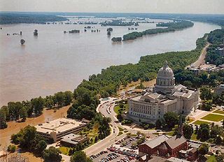
The Great Flood of 1993 was a flood that occurred in the Midwestern United States, along the Mississippi and Missouri rivers and their tributaries, from April to October 1993.

Hurricane Kathleen was a Category 1 Pacific hurricane that had a destructive impact in California. On September 7, 1976, a tropical depression formed; two days later it accelerated north towards the Baja California Peninsula. Kathleen brushed the Pacific coast of the peninsula as a hurricane on September 9 and made landfall as a fast-moving tropical storm the next day. With its circulation intact and still a tropical storm, Kathleen headed north into the United States and affected California and Arizona. Kathleen finally dissipated late on September 11.
Floods in the United States are generally caused by excessive rainfall, excessive snowmelt, and dam failure. Below is a list of flood events that were of significant impact to the country during the 20th century, from 1900 through 1999, inclusive.
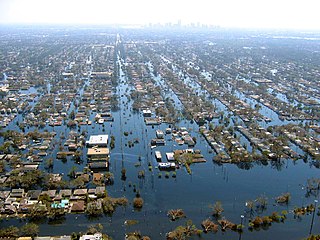
Floods in the United States (2000–present) is a list of flood events which were of significant impact to the country during the 21st century, since 2000. Floods are generally caused by excessive rainfall, excessive snowmelt, storm surge from hurricanes, and dam failure.

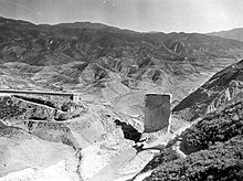
The Great Flood of 1862 was the largest flood in the recorded history of California, Oregon, and Nevada, inundating the western United States and portions of British Columbia and Mexico. It was preceded by weeks of continuous rains and snows that began in Oregon in November 1861 and continued into January 1862. This was followed by a record amount of rain from January 9–12, and contributed to a flood that extended from the Columbia River southward in western Oregon, and through California to San Diego, and extended as far inland as (now) Idaho in the Washington Territory, (now) Nevada and Utah in the Utah Territory, and (now) Arizona in the western New Mexico Territory. The event dumped an equivalent of 10 feet (3.0 m) of water in California, in the form of rain and snow, over a period of 43 days. Immense snowfalls in the mountains of far western North America caused more flooding in Idaho, Arizona, New Mexico, as well as in Baja California and Sonora, Mexico the following spring and summer, as the snow melted.

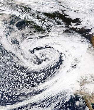
An atmospheric river (AR) is a narrow corridor or filament of concentrated moisture in the atmosphere. Other names for this phenomenon are tropical plume, tropical connection, moisture plume, water vapor surge, and cloud band.

An ARkStorm is a "megastorm" proposed scenario based on repeated historical occurrences of atmospheric rivers and other major rain events first developed and published by the Multi-Hazards Demonstration Project (MHDP) of the United States Geological Survey (USGS) in 2010 and updated as ARkStorm 2.0 in 2022.
The Los Angeles County flood of 2005 was the first large flood in Los Angeles County since 1938. It affected communities near the Los Angeles River and areas ranging from Santa Barbara County in the north to Orange and San Diego Counties in the south, as well as Riverside and San Bernardino Counties to the east. Large amounts of rain in January caused the Los Angeles River basin to overflow. The Ventura, Santa Ynez, and Santa Clara Rivers also flooded.

The December 2014 North American storm complex was a powerful winter storm that impacted the West Coast of the United States, beginning on the night of December 10, 2014, resulting in snow, wind, and flood watches. Fueled by the Pineapple Express, an atmospheric river originating in the tropical waters of the Pacific Ocean adjacent to the Hawaiian Islands, the storm was the strongest to affect California since January 2010. The system was also the single most intense storm to impact the West Coast, in terms of minimum low pressure, since a powerful winter storm in January 2008. The National Weather Service classified the storm as a significant threat, and issued 15 warnings and advisories, including a Blizzard Warning for the Northern Sierra Nevada.

The historical and ongoing droughts in California result from various complex meteorological phenomena, some of which are not fully understood by scientists.

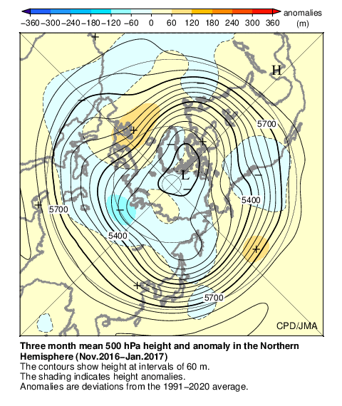
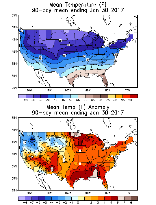
Flooding in 2017 affected parts of California in the first half of the year. Northern California saw its wettest winter in almost a century, breaking the record set in 1982–83. The same storm systems also flooded parts of western Nevada and southern Oregon. The damage was estimated at $1.55 billion ($1,926,663,046 today), including damage to California roads and highways estimated at more than $1.05 billion.

The 2011–2017 California drought persisted from December 2011 to March 2017 and consisted of the driest period in California's recorded history, late 2011 through 2014. The drought wiped out 102 million trees from 2011 to 2016, 62 million of those during 2016 alone. The cause of the drought was attributed to a ridge of high pressure in the Pacific Sea—the "Ridiculously Resilient Ridge"—which often barred powerful winter storms from reaching the state.
An extremely powerful extratropical bomb cyclone began in late October 2021 in the Northeast Pacific and struck the Western United States and Western Canada. The storm was the third and the most powerful cyclone in a series of powerful storms that struck the region within a week. The cyclone tapped into a large atmospheric river and underwent explosive intensification, becoming a bomb cyclone on October 24. The bomb cyclone had a minimum central pressure of 942 millibars (27.8 inHg) at its peak, making it the most powerful cyclone recorded in the Northeast Pacific. The system had severe impacts across Western North America, before dissipating on October 26. The storm shattered multiple pressure records across parts of the Pacific Northwest. Additionally, the bomb cyclone was the most powerful storm on record to strike the region, in terms of minimum central pressure. The bomb cyclone brought powerful gale-force winds and flooding to portions of Western North America. At its height, the storm cut the power to over 370,500 customers across the Western U.S. and British Columbia. The storm killed at least two people; damage from the storm was estimated at several hundred million dollars. The bomb cyclone was compared to the Columbus Day Storm of 1962, in terms of ferocity.

Periods of heavy rainfall caused by multiple atmospheric rivers in California between December 31, 2022, and March 25, 2023, resulted in floods that affected parts of Southern California, the California Central Coast, Northern California and Nevada. The flooding resulted in property damage and at least 22 fatalities. At least 200,000 homes and businesses lost power during the December-January storms and 6,000 individuals were ordered to evacuate.
In early February 2024, two atmospheric rivers brought extensive flooding, intense winds, and power outages to portions of California. The storms caused record-breaking rainfall totals to be observed in multiple areas, as well as the declaration of states of emergency in multiple counties in Southern California. Wind gusts of hurricane force were observed in San Francisco, along with wind gusts reaching over 100 miles per hour (160 km/h) in the Sierra Nevada mountains. Widespread landslides occurred as a result of the storms, as well as multiple rivers overflowing due to the excessive rainfall. Meteorologist Dr. Reed Timmer stated that "Biblical flooding" was possible throughout California during the atmospheric river.


