Los Angeles flood of 1938

Last updated

Los Angeles Flood of 1938
Los Angeles River - flood of 1938 aerial view above Victory Blvd (SPCOL20).jpg
The Los Angeles River overflowing its banks near Griffith Park

The Los Angeles flood of 1938 was one of the largest floods in the history of Los Angeles, Orange, and Riverside Counties in southern California. The flood was caused by two Pacific storms that swept across the Los Angeles Basin in February-March 1938 and generated almost one year's worth of precipitation in just a few days. Between 113–115 people were killed by the flooding. [1] The Los Angeles, San Gabriel, and Santa Ana Rivers burst their banks, inundating much of the coastal plain, the San Fernando and San Gabriel Valleys, and the Inland Empire. Flood control structures spared parts of Los Angeles County from destruction, while Orange and Riverside Counties experienced more damage. [1]

Contents

The flood of 1938 is considered a 50-year flood. [2] It caused $78 million of damage ($1.62 billion in 2022 dollars), [2] making it one of the costliest natural disasters in Los Angeles' history. [3] In response to the floods, the U.S. Army Corps of Engineers and other agencies began to channelize local streams in concrete, and built many new flood control dams and debris basins. These works have been instrumental in protecting Southern California from subsequent flooding events, such as in 1969 and 2005, which both had a larger volume than the 1938 flood. [3]

Background

This well constructed section of the Los Angeles River channel was one of the few sections of riverbank that withstood the 1938 flood. Los Angeles River - flood of 1938 near Laurel Canyon Road (SPCOL26).jpg
This well constructed section of the Los Angeles River channel was one of the few sections of riverbank that withstood the 1938 flood.

Due to its location between the Pacific Ocean and the high San Gabriel Mountains, the Los Angeles Basin is subject to flash floods caused by heavy orographic precipitation from Pacific storms hitting the mountains. Due to the arid climate, soils are too hard to absorb water quickly during storm events, resulting in large amounts of surface runoff. The steep, rocky terrain of the San Gabriel Mountains further contributes to the rapid runoff and resultant flooding hazard. [4]

Between February 27 and 28, 1938, a storm from the Pacific Ocean moved inland into the Los Angeles Basin, running eastward into the San Gabriel Mountains. The area received almost constant rain totaling 4.4 in (110 mm) from February 27-March 1. This caused minor flooding that affected only a few buildings in isolated canyons and some low-lying areas along rivers. [1] Fifteen hours later on March 1, at approximately 8:45 PM, a second storm hit the area, creating gale-force winds along the coast and pouring down even more rain. The storm brought rainfall totals to 10 in (250 mm) in the lowlands and upwards of 32 in (810 mm) in the mountains. [5] When the storm ended on March 3, the resulting damage was horrific. [1]

Effects

The 1938 flood destroyed 5,601 homes and businesses and damaged a further 1,500 properties. The flooding was accompanied by massive debris flows of mud, boulders, and downed trees, which surged out of the foothill canyons. Transport and communication were cut off for many days as roads and railroads were buried, and power, gas, and communication lines were cut. Dozens of bridges were destroyed by the sheer erosive force of floodwaters or by the collision of floating buildings and other wreckage. Some communities were buried as much as 6 feet (1.8 m) deep in sand and sediment, requiring a massive cleanup effort afterward. [4] It took from two days to a week to restore highway service to most impacted areas. The Pacific Electric rail system, serving Los Angeles, Orange, San Bernardino, and Riverside Counties, was out of service for three weeks. [4]

Although the 1938 flood caused the most damage of any flood in the history of Los Angeles, the rainfall and river peaks were not even close to the Great Flood of 1862, the largest known flood by total volume of water. However, during the 1862 flood, the region was much less populated than it was in 1938. [6]

Los Angeles area

Damage to the concrete channel at Tujunga Wash Los Angeles River - flood of 1938 - confluence of Tujunga Wash and LA River (SPCOL27).jpg
Damage to the concrete channel at Tujunga Wash

About 108,000 acres (44,000 ha) were flooded in Los Angeles County, with the worst hit area being the San Fernando Valley, where many communities had been built during the economic boom of the 1920s in low-lying areas once used for agriculture. [5] In fact, many properties were located in old river beds that had not seen flooding in some years. [1] Swollen by its flooded tributaries, the Los Angeles River reached a maximum flood stage of about 99,000 cubic feet per second (2,800 m3/s). [7] The water surged south, inundating Compton before reaching Long Beach, where a bridge at the mouth of the river collapsed killing ten people. [2] To the west, Venice and other coastal communities were flooded with the overflow of Ballona Creek. The Los Angeles Times chartered a United Air Lines Mainliner to provide them an aerial view of flooding damage. The reporter remarked: "Disaster, gutted farmlands, ruined roads, shattered communications, wrecked railroad lines—all leap into sharp-etched reality from that altitude." [8]

Communities and mining operations in the San Gabriel Mountains such as Camp Baldy were destroyed, stranding hundreds of people for days. [3] As many as 25 buildings were destroyed in the Arroyo Seco canyon, although due to a successful evacuation, no one was killed. [9] Two Civilian Conservation Corps camps, three guard stations and a ranger station were destroyed, along with 60 campgrounds. Almost every road and trail leading into the Angeles National Forest was damaged or destroyed by erosion and landslides. [10] About 190 men had to be evacuated from one of the CCC camps, near Vogel Flats, using a cable strung across Big Tujunga Canyon. [1]

The Tujunga Wash reached its peak flow on March 3, with a water flow of an estimated 54,000 cubic feet per second (1,500 m3/s). [11] Upper Big Tujunga Canyon was "all but swept clean of structures that were not up above the flood line". [9] In the San Fernando Valley, the floodwaters swept through many areas after escaping the normal channels of Tujunga Creek and its tributaries. Waters reached deep into the valley, the Pacoima Wash flooded Van Nuys. Five people died when the Lankershim Boulevard bridge collapsed at Universal City, just below the confluence of Tujunga Wash and the LA River. [9] [12] The flooding would have been much worse had a large debris flow not been halted at Big Tujunga Dam. Sam Browne, dam keeper during the 1938 flood, wrote that "Large oak trees several hundred years old rushed down the canyon like kindling... If this dam had never been built, there is no telling what would have happened to Sunland, and the city of Tujunga and the northern end of Glendale." [13] [14]

San Gabriel Valley

On the San Gabriel River, dams built prior to 1938 greatly reduced the magnitude of flooding. Along the West Fork the floodwaters first hit Cogswell Dam, which had been completed just four years earlier in 1934. Cogswell moderately reduced the flood crest on the West Fork, which further downstream joined with the undammed East Fork to peak at more than 100,000 cu ft/s (2,800 m3/s). The floodwaters poured into the reservoir of the still incomplete San Gabriel Dam, filling it over the night of March 2-3 and overtopping the emergency spillway. The maximum release from San Gabriel was held at 60,000 cu ft/s (1,700 m3/s), while the downstream Morris Dam further reduced the peak, to about 30,000 cu ft/s (850 m3/s). As a result, much of the San Gabriel Valley were spared from flooding, although heavy damage still occurred in some areas. [1] [15] In Azusa, four spans of the 1907 "Great Bridge" along the Monrovia–Glendora Pacific Electric line, which had survived the San Gabriel's seasonal flooding for over 30 years, were swept away in the torrent. [16]

Along the East Fork of the San Gabriel River, flooding obliterated much of a new highway that was intended to connect the San Gabriel Valley to Wrightwood. The southern stub of the highway has been rebuilt as today's East Fork Road, but north of Heaton Flat little remains except for the Bridge to Nowhere, a 120-foot (37 m) tall arch bridge that was saved due to its height above the floodwaters. Located about 5 miles (8.0 km) from the nearest road, the bridge is now a popular destination for hikers and bungee jumpers. [17]

Riverside and Orange Counties

Footage of flooding on the Santa Ana River, 1938

In Riverside and Orange Counties, the Santa Ana River reached a peak flow of about 100,000 cubic feet per second (2,800 m3/s), [18] completely overwhelming the surrounding dikes and transforming low-lying parts of Riverside County and Orange County into huge, shallow lakes. [19] A reporter for the Los Angeles Times described the river as "swollen crazy-mad". [20] Forty-three people were killed in Atwood and La Jolla in Placentia. [21] Flooding in the city of Riverside took another 15 lives. [2] The cities of Anaheim and Santa Ana in Orange County, were flooded up to 6 feet (1.8 m) deep for several weeks.

High Desert

Although most of the damage occurred on the windward (southwestern) side of the San Gabriel and San Bernardino Mountains, large amounts of rain also fell on the northeast side which drains to the Mojave Desert. The Little Rock Dam on Little Rock Creek overtopped during the flood due to a damaged spillway siphon that had been plugged by debris; hundreds of people in downstream Palmdale were evacuated. [1] Further east, the Mojave River burst its banks, damaging long stretches of the ATSF railroad and causing damage in Victorville and Barstow. The main line between Barstow and Los Angeles was closed for a week. [4] The Southern Pacific Railroad main line over Tehachapi Pass was closed for two weeks, requiring emergency service via buses and trucks. [4] Structures in the Acton area were also lost as the banks of the Santa Clara River crumbled, during the flood on March 2, 1938.

Aftermath

Aftermath of the flood in Anaheim, Orange County
Receding floodwaters downstream of Barham Blvd. Los Angeles River - flood of 1938, downstream from Barham Boulevard (SPCOL21).jpg
Receding floodwaters downstream of Barham Blvd.

Dams such as those at San Gabriel and Big Tujunga greatly reduced downstream damage in the 1938 flood. Many even larger dams were built after the flood to provide a greater degree of protection to downstream communities. Hansen Dam had already begun construction but stood incomplete during the 1938 flood and was unable to prevent the devastating flooding along Tujunga Wash. The dam was completed two years later, in 1940. [1] The Sepulveda Dam was built in 1941 to prevent the Los Angeles River from flooding the lower San Fernando Valley, Burbank and Glendale.

Along the San Gabriel River, the Santa Fe Dam and Whittier Narrows Dam had both been proposed prior to 1938, but had little political support until the devastation of the 1938 flood, after which federal funds were made available for both dams. [22] Santa Fe was completed in 1949, and Whittier Narrows in 1956. Construction was also expedited at Prado Dam, which had been planned in 1936 but work had not yet started at the time of the 1938 flood. Had Prado Dam been operational in 1938 it would likely have prevented the severe flooding in Orange County. [21] [23]

Although some river channel work was already in place at the time, the 1938 flood was the main impetus for channelizing the Los Angeles River in concrete, speeding the flow of floodwaters to the sea. The channelization project, authorized by the Flood Control Act of 1941, was undertaken by the U.S. Army Corps of Engineers starting just a few years after the 1938 flood, with emergency funding from the federal government. [1] About 278 miles (447 km) of streams in the Los Angeles River system were encased in concrete, a huge undertaking that took twenty years to complete. The system successfully protected Los Angeles from massive flooding in 1969. [5] The San Gabriel and Santa Ana Rivers were also ultimately channelized to protect against future floods, although it took much longer for those projects to be completed. [6]

In response to the large debris flows generated by the 1938 flood, the U.S. Forest Service was tasked with fire suppression in the Angeles Forest to reduce the risk of erosion in burned areas. [10]

Appearances in media

See also

Related Research Articles

<span class="mw-page-title-main">San Gabriel Mountains</span> Mountain range of the Transverse Ranges in California, United States

The San Gabriel Mountains comprise a mountain range located in northern Los Angeles County and western San Bernardino County, California, United States. The mountain range is part of the Transverse Ranges and lies between the Los Angeles Basin and the Mojave Desert, with Interstate 5 to the west and Interstate 15 to the east. The range lies in, and is surrounded by, the Angeles and San Bernardino National Forests, with the San Andreas Fault as its northern border.

<span class="mw-page-title-main">Santa Ana River</span> River in California, United States

The Santa Ana River is the largest river entirely within Southern California in the United States. It rises in the San Bernardino Mountains and flows for most of its length through San Bernardino and Riverside counties, before cutting through the northern Santa Ana Mountains via Santa Ana Canyon and flowing southwest through urban Orange County to drain into the Pacific Ocean. The Santa Ana River is 96 miles (154 km) long, and its drainage basin is 2,650 square miles (6,900 km2) in size.

<span class="mw-page-title-main">Seven Oaks Dam</span> Dam in near Mentone, California

Seven Oaks Dam is a 550-foot (170 m) high earth and rock fill embankment dam across the Santa Ana River in the San Bernardino Mountains, about 4 miles (6.4 km) northeast of Redlands in San Bernardino County, southern California. It impounds Seven Oaks Reservoir in the San Bernardino National Forest.

<span class="mw-page-title-main">Rio Hondo (California)</span> River in California, United States

The Rio Hondo is a tributary of the Los Angeles River in Los Angeles County, California, approximately 16.4 miles (26.4 km) long. As a named river, it begins in Irwindale and flows southwest to its confluence in South Gate, passing through several cities. Above Irwindale its main stem is known as Santa Anita Creek, which extends another 10 miles (16 km) northwards into the San Gabriel Mountains where the source, or headwaters, of the river are found.

<span class="mw-page-title-main">San Gabriel River (California)</span> River in Los Angeles County, California, United States

The San Gabriel River is a mostly urban waterway flowing 58 miles (93 km) southward through Los Angeles and Orange Counties, California in the United States. It is the central of three major rivers draining the Greater Los Angeles Area, the others being the Los Angeles River and Santa Ana River. The river's watershed stretches from the rugged San Gabriel Mountains to the heavily developed San Gabriel Valley and a significant part of the Los Angeles coastal plain, emptying into the Pacific Ocean between the cities of Long Beach and Seal Beach.

<span class="mw-page-title-main">Arroyo Seco (Los Angeles County)</span> Seasonal watercourse and human settlement in US

The Arroyo Seco, meaning "dry stream" in Spanish, is a 24.9-mile-long (40.1 km) seasonal river, canyon, watershed, and cultural area in Los Angeles County, California. The area was explored by Gaspar de Portolà who named the stream Arroyo Seco as this canyon had the least water of any he had seen. During this exploration he met the Chief Hahamog-na (Hahamonga) of the Tongva Indians.

<span class="mw-page-title-main">Hansen Dam</span> Dam in San Fernando Valley

Hansen Dam is a flood control dam in the northeastern San Fernando Valley, in the Lake View Terrace neighborhood of Los Angeles, California. The dam was built by the U.S. Army Corps of Engineers, Los Angeles District in 1940. Hansen Dam was named after horse ranchers Homer and Marie Hansen, who established a ranch in the 19th century.

<span class="mw-page-title-main">Tujunga Wash</span> Stream in Los Angeles County, California, US

Tujunga Wash is a 13-mile-long (20.9 km) stream in Los Angeles County, California. It is a tributary of the Los Angeles River, providing about a fifth of its flow, and drains about 225 square miles (580 km2). It is called a wash because it is usually dry, especially the lower reaches, only carrying significant flows during and after storms, which usually only occur between November and April. The name of the wash derives from a Tongva village name.

<span class="mw-page-title-main">San Juan Creek</span> River in Orange County, California, United States

San Juan Creek, also called the San Juan River, is a 29-mile (47 km) long stream in Orange and Riverside Counties, draining a watershed of 133.9 square miles (347 km2). Its mainstem begins in the southern Santa Ana Mountains in the Cleveland National Forest. It winds west and south through San Juan Canyon, and is joined by Arroyo Trabuco as it passes through San Juan Capistrano. It flows into the Pacific Ocean at Doheny State Beach. State Route 74, the Ortega Highway, crosses the Santa Ana Mountains via San Juan Canyon.

<span class="mw-page-title-main">Floods in California</span> History of floods in California

All types of floods can occur in California, though 90 percent of them are caused by river flooding in lowland areas. Such flooding generally occurs as a result of excessive rainfall, excessive snowmelt, excessive runoff, levee failure, poor planning or built infrastructure, or a combination of these factors. Below is a list of flood events that were of significant impact to California.

The Sierra Madre Dam is a dam on Little Santa Anita Creek, at the mouth of Little Santa Anita Canyon, in Los Angeles County, California. It is in the San Gabriel Mountains, south of the Angeles National Forest, on the northern border of Sierra Madre.

<span class="mw-page-title-main">Coyote Creek (San Gabriel River tributary)</span> Tributary of the San Gabriel River in California

Coyote Creek is a principal tributary of the San Gabriel River in northwest Orange County and southeast Los Angeles County, California. It drains a land area of roughly 41.3 square miles (107 km2) covering eight major cities, including Brea, Buena Park, Fullerton, Hawaiian Gardens, La Habra, Lakewood, La Palma, and Long Beach. Some major tributaries of the creek in the highly urbanized watershed include Brea Creek, Fullerton Creek, and Carbon Creek. The mostly flat creek basin is separated by a series of low mountains, and is bounded by several small mountain ranges, including the Chino Hills, Puente Hills, and West Coyote Hills.

<span class="mw-page-title-main">Pacoima Wash</span> River in the United States

Pacoima Wash, 33 miles (53 km) long, is a major tributary of the Tujunga Wash, itself a tributary of the Los Angeles River, in the San Fernando Valley of Los Angeles County, California.

<span class="mw-page-title-main">San Gabriel Dam</span> Dam in Los Angeles County, California

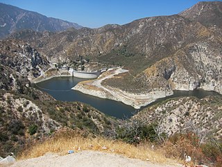
San Gabriel Dam is a rock-fill dam on the San Gabriel River in Los Angeles County, California, within the Angeles National Forest. Completed in 1939, the dam impounds the main stem of the San Gabriel River about 2.5 miles (4.0 km) downstream from the confluence of the river's East and West Forks, which drain a large portion of the San Gabriel Mountains. It is located directly upstream from the Morris Dam. The dam provides flood control, groundwater recharge flows and hydroelectricity for the heavily populated San Gabriel Valley in the Greater Los Angeles metropolitan area.

<span class="mw-page-title-main">Chino Creek</span> River in California, United States

Chino Creek is a major stream of the Pomona Valley, in the western Inland Empire region of Southern California. It is a tributary of the Santa Ana River.

<span class="mw-page-title-main">Big Tujunga Creek</span> River in California, United States

Big Tujunga Creek is a major stream in Los Angeles County in the U.S. state of California. From its headwaters high in the San Gabriel Mountains, it flows generally southwest for 28.8 miles (46.3 km), joining Little Tujunga Creek to form the Tujunga Wash near Pacoima. The stream is sometimes considered as one with the Tujunga Wash, which is the continuation of Big Tujunga to the Los Angeles River, bringing the total length to more than 40 miles (64 km). The name of the stream is derived from a Tongva village name.

San Antonio Creek is a major stream in Los Angeles County and San Bernardino County, California, draining southwards from Mount San Antonio in the San Gabriel Mountains into Chino Creek, a tributary of the Santa Ana River. Upon leaving San Antonio Canyon and entering the broad alluvial plain of the Pomona Valley, it is known as the San Antonio Wash or the San Antonio Creek Channel, the former referring to the creek's seasonal dry nature below the mouth of San Antonio Canyon.

<span class="mw-page-title-main">Big Tujunga Dam</span> Dam in Los Angeles County, California

Big Tujunga Dam is a 244-foot-high (74 m) concrete arch dam in Los Angeles County, California, spanning Big Tujunga Canyon northeast of Sunland, in the foothills of the San Gabriel Mountains. Completed in 1931, it provides flood control and groundwater recharge for the San Fernando Valley.

<span class="mw-page-title-main">San Dimas Dam</span> Dam in Los Angeles County, California

San Dimas Dam is a concrete gravity dam in Los Angeles County, California. The dam and its flood control basin/reservoir are in the San Gabriel Mountains and within the Angeles National Forest. The dam is currently operated by the Los Angeles County Department of Public Works but was originally built by the Los Angeles County Flood Control District in 1922. The dam controls flooding from San Dimas Creek, a major San Gabriel Mountains drainage and tributary of the San Gabriel River. As a flood control facility the San Dimas Reservoir is dry for most of the year, only storing water after significant winter storms. The regulation provided by the dam allows for the efficient diversion of floodwaters from San Dimas Wash to Puddingstone Reservoir, which protects the San Dimas area of the San Gabriel Valley.

References

  1. 1 2 3 4 5 6 7 8 9 10 "Los Angeles Basin's 1938 Catastrophic Flood Event". Archived from the original on May 9, 2009. Retrieved May 12, 2009.
  2. 1 2 3 4 Romo, Rene (February 22, 1988). "Flood of Memories : Longtime Valley Residents Recall 1938 Deluge That Took 87 Lives, Did $78 Million in Damage". Los Angeles Times. Retrieved August 17, 2017.
  3. 1 2 3 "The History of the Los Angeles River". L.A. River Connection. Archived from the original on June 11, 2007.
  4. 1 2 3 4 5 Panhorst, F.W. (August 1938). "Role of Highways in Recent California Floods: Road Network Takes On Added Value in Time of Emergency". Civil Engineering. SCV History. 8 (8): 542–544. Retrieved August 17, 2017.
  5. 1 2 3 Cram, Justin (February 28, 2012). "Los Angeles Flood of 1938: Cementing the River's Future". Departures. KCET. Retrieved July 22, 2013.
  6. 1 2 Masters, Nathan (March 3, 2017). "The Southern California Deluge of 1938". KCET. Retrieved August 17, 2017.
  7. "USGS Gage #11103000 Los Angeles River at Long Beach, CA". National Water Information System. U.S. Geological Survey. 1929–1992. Retrieved August 17, 2017.
  8. “Plane trip shows scene of desolation.” In Los Angeles Times, March 4, 1938, pp. 1-2.
  9. 1 2 3 “Scores trapped in mountains: Pilots report canyon retreats destroyed or heavily damaged.” In Los Angeles Times, March 5, 1938, p. 7.
  10. 1 2 Cermak, Robert W. (2005). Fire in the Forest: A History of Forest Fire Control on the National Forests in California, 1898-1956. USDA Forest Service. p. 200. ISBN   1-59351-429-8.
  11. "USGS Gage #11097000 Big Tujunga Creek below Hansen Dam, CA". National Water Information System. U.S. Geological Survey. 1933–2016. Retrieved August 17, 2017.
  12. Roderick, Kevin (October 20, 1999). "Deadly Flood of 1938 Left Its Mark on Southland". Los Angeles Times. Retrieved August 17, 2017.
  13. Bartholomew, Dana (July 21, 2011). "Dam renovation expected to help cut water costs". Los Angeles Daily News. Retrieved August 17, 2017.
  14. “Small Losses prove value of dam system: Huge amounts of water stored and damage held to minimum” in Los Angeles Times, March 4, 1938, p. 7.
  15. Medina, Daniel (March 20, 2014). "The Other River that Defined L.A.: The San Gabriel River in the 20th Century". KCET. Retrieved August 17, 2017.
  16. "Los Angeles Raiders Football Stadium, Irwindale, Parking and Associated Facilities Development: Environmental Impact Statement, Volume 2". U.S. Army Corps of Engineers. 1988. p. 35. Retrieved August 17, 2017.
  17. Goran, David (June 2, 2016). "The Bridge to Nowhere – One of the most bizarre artifacts to be found deep in the San Gabriel Mountains". The Vintage News. Retrieved August 17, 2017.
  18. "USGS Gage #11074000 Santa Ana River below Prado Dam, CA". National Water Information System. U.S. Geological Survey. 1938–2016. Retrieved August 17, 2017.
  19. Gold, Scott (October 3, 1999). "1938 Flood: A Watershed for the County". Los Angeles Times . Retrieved March 19, 2017.
  20. “Plane trip shows scene of desolation.” In Los Angeles Times, March 4, 1938, pp. 1-2.
  21. 1 2 Masters, Nathan (November 29, 2012). "The Santa Ana River: How It Shaped Orange County". KCET. Retrieved August 17, 2017.
  22. Elkind, Sarah S. (2011). How Local Politics Shape Federal Policy: Business, Power, and the Environment in Twentieth-century Los Angeles. University of North Carolina Press. pp. 92–94. ISBN   978-0-80783-489-3.
  23. "History of the Santa Ana River" (PDF). Santa Ana River Vision Plan. City of Santa Ana. Archived from the original (PDF) on July 20, 2011. Retrieved August 17, 2017.
  24. "California Floods Aka Raging Torrents In California (1938)".