
Flooding in Jakarta occurs on the northwest coast of Java, at the mouth of the Ciliwung River on Jakarta Bay, which is an inlet of the Java Sea and has happened recently in 1996, 1999, 2007, 2013, and 2020. [1]
Flooding in Jakarta occurs on the northwest coast of Java, at the mouth of the Ciliwung River on Jakarta Bay, which is an inlet of the Java Sea and has happened recently in 1996, 1999, 2007, 2013, and 2020. [1]
The area of the Jakarta Special District is 662 km2 of land area and 6,977 km2 of sea area. [2]
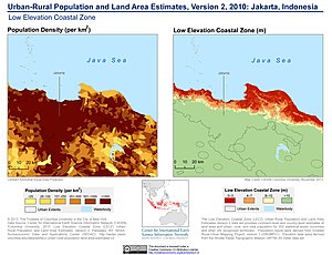
Jakarta lies in a low, flat basin, averaging 7 metres (23 ft) above sea level;[ citation needed ] 40% of Jakarta, particularly the northern areas, is below sea level, [3] while the southern parts are comparatively hilly.
Rivers flow from the Puncak highlands to the south of the city, across the city northwards towards the Java Sea; the Ciliwung River, divides the city into the western and eastern principalities. Other rivers include the Pesanggrahan, and Sunter high sea tides.
Other contributing factors include clogged sewage pipes and waterways that service an increasing population, in addition to deforestation near rapidly urbanizing Bogor and Depok in Jakarta's hinterland.
Jakarta is an urban area with complex socio-economic problems that indirectly contribute to triggering a flood event. [4]
In February 1960, flooding occurred in the new suburb of Grogol. Despite the flood-proof planning of Grogol suburb, the area was flooded to knee and waist height. This was the first crisis for Governor Soemarno who was installed only days before the floods began. [5]
Major floods occurred in 1996 [6] [7] when 5,000 hectares of land were flooded. [8]
Major floods also occurred in 2007. [9] Losses from infrastructure damage and state revenue were at least 5.2 trillion rupiah (572 million US dollars) and at least 190,000 people have fallen ill due flood related illnesses. Approximately 70% of Jakarta's total area was flooded with water up to four meters deep in parts of the city. [10] [11] 80 people were killed in the floods.

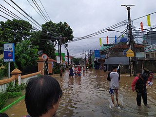
On January 15, 2013, a serious flood affected downtown Jakarta, as well as several other areas surrounding the city, such as West Java and Banten, as a result of heavy rain and waterways clogged with garbage and other kinds of debris. A 30-meter-long section of Jakarta's West Flood Canal dike on Jalan Johannes Latuharhary in Menteng collapsed, which quickly caused flooding in nearby areas. Military personnel, the Jakarta public works agency, and public order officers joined forces to quickly replace the collapsed dike section with a temporary retaining wall made of rocks and sandbags. Workers finished rebuilding a section of a canal dike. [12] Flooding was reported at the presidential palace, forcing the postponement of a meeting between President Susilo Bambang Yudhoyono and his visiting Argentine counterpart, Cristina Fernandez. [13] There were 47 deaths being reported. [14] Evacuations were carried out in parts of Jakarta. An estimated 20,000 people were evacuated as of 17 January 2013 [15] [16]
Floods occurred throughout Jakarta, Bogor, Tangerang, and Bekasi on the early hours of January 1, 2020, due to the overnight rain which dumped nearly 381 mm (15.0 in) — more than 3 times the average amount. [17] The massive downpour caused the Ciliwung and Cisadane river to overflow. [18] Multiple floodgates were assigned emergency status due to the high water levels after the rainfall. [19]
At least 48 deaths had been reported, due to landslides, hypothermia, drowning, and electrocution. [20] [21] Many parts of the city had been left without power, as the power was switched off for safety reasons. [22] [23]
Multiple transportation networks were disrupted including light rail transit, [24] taxis, [25] [26] trains, [27] toll roads, [28] and an airport. [29] Sukarno-Hatta Airport and the Mass Rapid Transit lines were operating as per normal. [30] [31]
Halim Perdanakusuma Airport was closed early in the morning due to the airport runways being submerged. Air traffic was temporarily redirected to Sukarno-Hatta Airport. [29] Halim Perdanakusuma was reopened a couple of hours later.
From 6pm on January 1 until 12pm on January 2, 2020, the government temporarily waived all toll road fees in Jakarta. [32]
At many parts of the city, water levels reached 30 to 200 cm. At some places, such as Cipinang Melayu, East Jakarta, water levels peaked at 4 meters. [33] More than 19,000 residents had been evacuated to higher grounds. The government had designated schools and government buildings as temporary shelters. [34] In several areas, evacuation efforts were hampered by rushing waters and blackouts. [35] [36]
On 25 February 2020, Jakarta witnessed another flood. [37]
Several areas in Jakarta and the neighbouring cities of Tangerang and Bekasi were inundated in water up to 2m deep on 20 February. At least five people were killed, four of them were children who were swept away by the strong river currents in separate places in South and West Jakarta. Two hundred neighbourhoods have been affected and some 1,380 Jakarta residents were evacuated. [38]
East Flood Canal (Banjir Kanal Timur, BKT) in eastern Jakarta was a national project which began in 2003 and late 2009 reached the Java sea and will be accomplished in 2011. It was 23.5 kilometers length which linking five rivers: Cipinang, Sunter, Buaran, Jati Kramat and Cakung. It will reduce flood and hope as a 2 kilometers rowing sport venue too. [39] To ease from flood, Jakarta Emergency Dredging Initiative (JEDI) phase-2 will make underground canal (siphon) from Ciliwung river to Cipinang river and then go through to East Flood Canal. It will lower floods at Cawang, Kampung Melayu, Bukit Duri and Kebun Baru. It is one kilometer long and was finished in 2016. [40]
For managing risk effectively, it needs extensive data for making decisions on investments in preparedness, mitigation, and response. Until recently, detailed information on disaster situation (flooding) was hardly available at local level. A pilot project in Jakarta, led by the Province of Jakarta's Disaster Management Agency collected high-resolution data to inform flood preparedness and contingency. Later, the data, which was accessible by the community and the general public, was used in 2011/2012 Jakarta contingency emergency planning exercise. The risk information it produced was very useful for decision makers in preparedness, development and investment planning. [41] Petabencana.id can now be consulted and it contains a flood map. [42] [43] Some additional info may be found at OpenStreetMap. It is an online, open-source platform, which relies on participatory mapping conducted by local communities, private and public actors who collect the detailed information about a given area and share it, meet the needs in disaster situation.
Alongside flooding from rivers, Jakarta is also sinking about 5 to 10 centimeters each year and up to 20 centimeters in northern Jakarta mainland. From 2000 to 2050, the potential coastal flood extent is estimated to increase by 110.5 km2 due to both land subsidence and sea level rise. [44] Land subsidence in Jakarta is mainly caused by the overuse of groundwater. [45] At the same time, the groundwater has lost its capacity to recharge due to the lack of watershed areas and overpopulation in the capital. Without any groundwater regulation in place, buildings in Jakarta are drawing water from the ground at an unprecedented rate. For households, especially those at the bottom of the economic pyramid, access to piped water is considered a luxury. Not only must the customer pay for the tariff, which is higher than other Indonesian cities, [46] the installment fees often burden the poor households to connect to the tap.
In addition, residents consider piped water (and to some extent groundwater) quality in Jakarta to be of poor quality, thus explaining why only 28 percent of Jakarta households drink piped water and groundwater compared to 95 percent in 2000. [47] Apart from drinking, people in Jakarta still use groundwater, and to some extent piped water and wended water. [48] Such hydrological behaviour has led to the overuse of groundwater, thus contributing to the land subsidence.
In an effort to solve the problem, the Netherlands will give $4 million for a feasibility study to build a dike on Jakarta Bay. The ring dike will be provided with pumping system and retention area, would regulate and control seawater and would also be used as an additional toll road. The project will be built by 2025. [49] Construction of an 8 km sea wall along the coast was officially launched on October 9, 2014. [50]

Jakarta, officially the Special Capital Region of Jakarta and formerly Batavia, is the capital and largest metropolis of Indonesia. Lying on the northwest coast of Java, the world's most populous island, Jakarta is the largest metropole in Southeast Asia, and serves as the diplomatic capital of ASEAN. Jakarta is bordered by two Sundanese provinces: West Java to the south and east; and, since 2000, Banten to the west. Its coastline faces the Java Sea to the north, and it shares a maritime border with Lampung to the west.

The Ciliwung is a 119km long river in the northwestern region of Java where it flows through two provinces, West Java and the special region of Jakarta. The natural estuary of the Ciliwung river, known as the Kali Besar, was an important strategic point for trade in the precolonial and colonial periods and was instrumental in the founding of the port city of Jakarta, but has been lost from reorganization of the watercourse of the rivers around the area into canals.

Penjaringan is a subdistrict of North Jakarta, Indonesia. It is the westernmost subdistrict of North Jakarta. Muara Angke port and the mouth of Sunda Kelapa Port are located within Penjaringan. Penjaringan contains the remnants of the original mangrove forest of Jakarta, some of which is protected by the Muara Angke Wildlife Sanctuary.

The 2013 Jakarta flood was a flood in Jakarta, the capital of Indonesia, which, in addition to areas in downtown Jakarta, also affected several other areas surrounding the city, such as West Java and Banten.

The Jakarta Flood Canal refers to two canals that divert floods from rivers around Jakarta instead of going through the city. This first flood control channel was designed by Hendrik van Breen, an engineer working for the Dutch East Indian Department van Burgelijke Openbare Werken, after a big flood hit the city on 13 February 1918.
The Angke River is a 91.25-kilometre (56.70 mi) long river in Jakarta, Indonesia. The river flows from the Bogor area of West Java, passing through the cities of Tangerang (Banten) and Jakarta into the Java Sea via the Cengkareng Drain. The river is connected with the Cisadane River by Mookervaart Canal.

Batavia Castle was a fort located at the mouth of Ciliwung River in Jakarta. Batavia Castle was the administrative center of Dutch East India Company (VOC) in Asia.
The Pesanggrahan River is a river with the upstream in the Bogor Regency, flowing through the cities of Depok, Jakarta and Tangerang, Banten. The river passes the districts of Tanah Sereal, Bojong Gede, Sawangan, Limo, Kebayoran Lama, Pesanggrahan, Kembangan, and Kebun Jeruk before flowing into the Cengkareng Drain. Based on 2005 data, 55 percent of the watershed area of the Pesanggrahan River is occupied by housing, only 7 percent is still forests, 20 percent rice fields, and 13 percent other agriculture fields.
The Krukut River is a river flowing in Jakarta originating in Bogor Regency. In the past the river was clean and one of the tourist attractions during the Dutch East Indies administration, but due to denser housing on the banks and lack of maintenance, the water turned dark and filled with trash, causing routine flooding in rainy seasons.
The Jatikramat River is a river in Bekasi, West Java, and the eastern part of the Special Capital Region of Jakarta, Indonesia. The lower portions of the original river have been channelized and directed into the eastern flood canal, "Banjir Kanal Timur", which continues to flow to the Java Sea in the district of Marunda, Cilincing, North Jakarta. The river regularly causes flooding in the city of Bekasi and Jakarta.
Cakung River is a river in the Bekasi, West Java and eastern part of the Special Capital Region of Jakarta, Indonesia. The lower portions of the original river have been channelized and directed into the eastern flood canal, "Banjir Kanal Timur", which continues to flow to the Java Sea in the district of Marunda, Cilincing, North Jakarta. The river regularly causes flooding in the city of Bekasi and Jakarta.
The Buaran River is a river flowing in the Bekasi, West Java and eastern part of the Special Capital Region of Jakarta, Indonesia. The lower portions of the original river have been channelized and directed into the eastern flood canal, "Banjir Kanal Timur", which continues to flow to the Java Sea in the district of Marunda, Cilincing, North Jakarta. The river regularly causes flooding in the city of Bekasi and Jakarta.
The Cipinang River is a river in the Special Capital Region of Jakarta, Indonesia. The Cipinang River is a tributary of Sunter River, conjoining near I Gusti Ngurah Rai Street and Cipinang Muara Ilir Street, Jakarta, but in the middle it is cut by the beginning of Banjir Kanal Timur, near Cipinang Besar Selatan Street and IPN Street, Jakarta. The river flows mainly in the district of Makassar, East Jakarta, with many houses built on both banks.
Baru Timur River is a man-made canal flowing from Ci Liwung in Bogor Regency to Jakarta, Indonesia. It was one of two canals built in the 18th century under the order of the Governor-General Gustaaf Willem van Imhoff originally to transport agriculture harvest from Bogor to Batavia. Currently both canals, now known as Kali Baru Timur and Kali Baru Barat, are among the main rivers in Jakarta, and part of the Ciliwung Cisadane flood control project. Baru Timur River flows from Katulampa flood gate, built at the same time as the canal, along the major road Bogor Highway, passing Cimanggis, Depok, Cilangkap, until reaching Java Sea in Kali Besar, Tanjung Priok, North Jakarta.
The Baru Barat River is a man-made canal flowing from the Cisadane River in Bogor Regency to Jakarta, Indonesia. It was one of two canals built in the 18th century under the order of the Governor-General Gustaaf Willem van Imhoff, the other being the Baru Timur River. Both canals were originally built to transport agricultural harvests from Bogor to Batavia. They are among the main rivers in Jakarta, and part of the Ciliwung Cisadane flood control project. The Baru Barat River flows through the districts of Pancoran and Tebet in South Jakarta, and drains into the Banjir Kanal Barat.
On 22 January 2019, floods caused by heavy rainfall struck the Indonesian province of South Sulawesi. At least 68 people were killed and thousands were displaced. Gowa Regency was particularly hard-hit, experiencing the majority of the fatalities.
Flash floods occurred throughout the Indonesian capital of Jakarta and its metropolitan area on the early hours of 1 January 2020, due to the overnight rain which dumped nearly 400 millimetres (15 in) of rainwater, causing the Ciliwung and Cisadane rivers to overflow. At least 66 people have been killed, and 60,000 displaced in the worst flooding in the area since 2007.
From 3 to 8 December 2020, several floods and flash floods impacted various areas within Indonesia and Malaysia, causing mass property damage, injuring and killing many, and prompting the evacuation of those in affected houses. They were caused by a convergence zone formed by Cyclone Burevi in Sri Lanka and a low-pressure area in the Philippines. Wider coverage was done on the floods in the province of North Sumatra, which killed eight, injured 5,000, and damaged over 2,000 properties. The ones in neighboring province Aceh affected over 8,000 people, and those in Malaysia affected over 2,000 people across four states. Meanwhile, floods also impacted the Indonesian island of Java, though with less severity.

Heru Budi Hartono is an Indonesian bureaucrat who has been the acting Governor of Jakarta since 2022 and Head of the Presidential Secretariat since 2017. He was the former Head of Jakarta Regional Asset Financial Management Agency under Governor Basuki Tjahaja Purnama between 2015 and 2017. A former mayor of North Jakarta, Heru was appointed by Governor Basuki to be a candidate for deputy governor in the 2017 Jakarta Regional Head Elections if he only advanced through an independent path. He is currently the acting Governor of Jakarta replacing Anies Baswedan since 17 October 2022, until the 2024 Jakarta election.