
The Ciliwung is a 119km long river in the northwestern region of Java where it flows through two provinces, West Java and the special region of Jakarta. The natural estuary of the Ciliwung river, known as the Kali Besar, was an important strategic point for trade in the precolonial and colonial periods and was instrumental in the founding of the port city of Jakarta, but has been lost from reorganization of the watercourse of the rivers around the area into canals.

Pasar Minggu is a district in the administrative city of South Jakarta, Indonesia. The area is known for its traditional Sunday market, famous for the fruit market. Historically, Pasar Minggu is a fruit cultivation area developed by the Dutch government during the colonial period. The central point of the cultivation area is the traditional market of Pasar Minggu, located in what is now the lower-division Pasar Minggu subdistrict. Teak forest could also be found in Pasar Minggu district, notably around Jati Padang subdistrict. Most of these areas has been converted into residential area as Jakarta grow southward.
Tebet is a district in the administrative city of South Jakarta, Indonesia. The boundaries of Tebet are Jend. Gatot Subroto-Letjen Haryono MT. tollway to the south, Ciliwung River to the east, Jalan Casablanca - Ciliwung River to the north, and Cideng River to the west. This district is home to SMA Negeri 8 Jakarta

Cilincing is a historic neighborhood of the coast of Jakarta, Indonesia. It is sandwiched between the Port of Tanjung Priok to the west and River Titram to the east. Cilincing has been for some decades one of the districts of North Jakarta which in turn encompasses as far as Marunda and some non-coastal hinterland.

Kota Tua Jakarta, officially known as Kota Tua, is a neighborhood comprising the original downtown area of Jakarta, Indonesia. It is also known as Oud Batavia, Benedenstad, or Kota Lama.

Jalan H.R. Rasuna Said or Jalan Rasuna Said is one of the main avenues of Jakarta, Indonesia. It was constructed during the 1970s. It is located in the Golden Triangle of Jakarta. The road was named after Hajjah Rangkayo Rasuna Said, a National Hero of Indonesia. The road runs 4.9 km (3.0 mi) from Setiabudi, South Jakarta, to Tendean, Mampang Prapatan, South Jakarta. The Rasuna Said Street is also one of the Odd–even Traffic Restriction Scheme implementation zones.

Flooding in Jakarta occurs on the northwest coast of Java, at the mouth of the Ciliwung River on Jakarta Bay, which is an inlet of the Java Sea and has happened recently in 1996, 1999, 2007, 2013, and 2020.

The Angke River is a 91.25-kilometre (56.70 mi) long river in Jakarta, Indonesia. The river flows from the Bogor area of West Java, passing through the cities of Tangerang (Banten) and Jakarta into the Java Sea via the Cengkareng Drain. The river is connected with the Cisadane River by Mookervaart Canal.

Batavia Castle was a fort located at the mouth of Ciliwung River in Jakarta. Batavia Castle was the administrative center of Dutch East India Company (VOC) in Asia.
The Mookervaart River is a canal connecting the Cisadane River in Tangerang and Kali Angke in Jakarta. Constructed from 1678 to 1689, this 25–30 meter wide channel is one of the important flood control water channels in Jakarta.
The Krukut River is a river flowing in Jakarta originating in Bogor Regency. In the past the river was clean and one of the tourist attractions during the Dutch East Indies administration, but due to denser housing on the banks and lack of maintenance, the water turned dark and filled with trash, causing routine flooding in rainy seasons.
The Jatikramat River is a river in Bekasi, West Java, and the eastern part of the Special Capital Region of Jakarta, Indonesia. The lower portions of the original river have been channelized and directed into the eastern flood canal, "Banjir Kanal Timur", which continues to flow to the Java Sea in the district of Marunda, Cilincing, North Jakarta. The river regularly causes flooding in the city of Bekasi and Jakarta.
Cakung River is a river in the Bekasi, West Java and eastern part of the Special Capital Region of Jakarta, Indonesia. The lower portions of the original river have been channelized and directed into the eastern flood canal, "Banjir Kanal Timur", which continues to flow to the Java Sea in the district of Marunda, Cilincing, North Jakarta. The river regularly causes flooding in the city of Bekasi and Jakarta.
The Buaran River is a river flowing in the Bekasi, West Java and eastern part of the Special Capital Region of Jakarta, Indonesia. The lower portions of the original river have been channelized and directed into the eastern flood canal, "Banjir Kanal Timur", which continues to flow to the Java Sea in the district of Marunda, Cilincing, North Jakarta. The river regularly causes flooding in the city of Bekasi and Jakarta.
The Cipinang River is a river in the Special Capital Region of Jakarta, Indonesia. The Cipinang River is a tributary of Sunter River, conjoining near I Gusti Ngurah Rai Street and Cipinang Muara Ilir Street, Jakarta, but in the middle it is cut by the beginning of Banjir Kanal Timur, near Cipinang Besar Selatan Street and IPN Street, Jakarta. The river flows mainly in the district of Makassar, East Jakarta, with many houses built on both banks.
Baru Timur River is a man-made canal flowing from Ci Liwung in Bogor Regency to Jakarta, Indonesia. It was one of two canals built in the 18th century under the order of the Governor-General Gustaaf Willem van Imhoff originally to transport agriculture harvest from Bogor to Batavia. Currently both canals, now known as Kali Baru Timur and Kali Baru Barat, are among the main rivers in Jakarta, and part of the Ciliwung Cisadane flood control project. Baru Timur River flows from Katulampa flood gate, built at the same time as the canal, along the major road Bogor Highway, passing Cimanggis, Depok, Cilangkap, until reaching Java Sea in Kali Besar, Tanjung Priok, North Jakarta.
The Baru Barat River is a man-made canal flowing from the Cisadane River in Bogor Regency to Jakarta, Indonesia. It was one of two canals built in the 18th century under the order of the Governor-General Gustaaf Willem van Imhoff, the other being the Baru Timur River. Both canals were originally built to transport agricultural harvests from Bogor to Batavia. They are among the main rivers in Jakarta, and part of the Ciliwung Cisadane flood control project. The Baru Barat River flows through the districts of Pancoran and Tebet in South Jakarta, and drains into the Banjir Kanal Barat.
Alwi Shahab was an Indonesian journalist for more than 40 years who mainly focused on Jakarta's socio-cultural problems. His career began in 1960 as a journalist at the Arabian Press Board news agency in Jakarta.
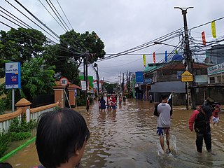
Flash floods occurred throughout the Indonesian capital of Jakarta and its metropolitan area on the early hours of 1 January 2020, due to the overnight rain which dumped nearly 400 millimetres (15 in) of rainwater, causing the Ciliwung and Cisadane rivers to overflow. At least 66 people have been killed, and 60,000 displaced in the worst flooding in the area since 2007.

The Rajawali–Cikampek railway is a railway line that connects Rajawali Station and Cikampek Station. This route crosses two provinces with 5 regencies or cities, namely Jakarta and West Java. This line is one of the busiest intercity lines in Indonesia and since the 1920s it has been a double track and has been electrified since 1992.
