Tangerang is a city in the province of Banten, Indonesia. Located on the western border of Jakarta, it is the third largest urban centre in the Greater Jakarta metropolitan area after Jakarta and Bekasi; the sixth largest city proper in the nation; and the largest city in Banten province. It has an area of 164.55 km2 (63.53 sq mi) and an official 2010 Census population of 1,798,601, which had risen to 1,895,486 at the 2020 Census – making it the eighth most populated suburb in the world at the latter date; the official estimate as at mid 2023 was 1,912,679 - comprising 961,354 males and 951,325 females.

North Jakarta is one of the five administrative cities which form Special Capital Region of Jakarta, Indonesia. North Jakarta is not self-governed and does not have a city council, hence it is not classified as a proper municipality. It contains the entire coastal area within the Jakarta Special Capital Region. North Jakarta, along with South Jakarta is the only two cities in Jakarta to border Banten and West Java. It is also the only two cities and regencies of Jakarta with a coastline and not landlocked along with the Thousand Islands Regency. North Jakarta, an area at the estuary of Ciliwung river was the main port for the kingdom of Tarumanegara, which later grew to become Jakarta. Many historic sites and artefacts of Jakarta can be found in North Jakarta. Both ports of Tanjung Priok and historic Sunda Kelapa are located in the city. The city, which covers an area of 139.99 km2, had 1,645,659 inhabitants at the 2010 census and 1,778,981 at the 2020 census; the official estimate as at mid 2022 was 1,793,550 - comprising 905,575 males and 887,975 females. It has its administrative centre in Tanjung Priok.

Kembangan is a district in West Jakarta, Indonesia. Kembangan is bounded by Pesanggrahan Subdistrict to the south, Tangerang Regency to the south and west, Cengkareng Subdistrict to the north, and Kebon Jeruk Subdistrict to the east. The City Hall of West Jakarta is located in this district.

Grogol Petamburan is a district of West Jakarta, Indonesia, roughly bounded by the West Flood Canal to the east, Angke Canal to the west and to the north, and Jakarta-Merak Tollway to the south. It has an area 1,130 ha. As of 2004, the use of the land was 58.0% for housing, 12.5% for offices, 3.8% in parkland, and 2.2% in farmland with the remainder in other uses or idle.
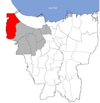
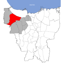
Kalideres is a district of West Jakarta, Indonesia and is the westernmost district of Jakarta. Kalideres covers 3,023.36 hectares and is bounded by Tangerang Regency to the north, Penjaringan District to the northeast, Cengkareng District to the east and Tangerang City to the south and west.
Kebon Jeruk is a subdistrict (kecamatan) of West Jakarta, Indonesia. Kebon Jeruk is roughly bounded by Kali Pesanggrahan creek to the west, Kebayoran Lama Road to the south, Daan Mogot Road to the north, and Rawa Belong - Batu Sari Road to the east. The area is approximately 18 square km.

Tambora is a subdistrict of West Jakarta, Indonesia. Tambora Subdistrict is bounded by a railway to the west and to the north, Kali Krukut - Kali Besar canal to the east, and Duri Selatan Road to the south.

Penjaringan is a subdistrict of North Jakarta, Indonesia. It is the westernmost subdistrict of North Jakarta. Muara Angke Port and the mouth of Sunda Kelapa Port are located within Penjaringan. Penjaringan contains the remnants of the original mangrove forest of Jakarta, some of which are protected by the Muara Angke Wildlife Sanctuary.

Postal codes in Indonesia, known in Indonesian as kode pos consist of 5 digits.
Kedaung Kali Angke is a subdistrict in the Cengkareng district of Indonesia. It has postal code of 11710. The administrative village's area is 2.61 km2 (1.01 sq mi).

The Jakarta Flood Canal refers to two canals that divert floods from rivers around Jakarta instead of going through the city. This first flood control channel was designed by Hendrik van Breen, an engineer working for the Dutch East Indian Department van Burgelijke Openbare Werken, after a big flood hit the city on 13 February 1918.

Duri Station (DU) is a railway station located in West Jakarta. It serves as the starting point and the eastern terminus of the Tangerang Line service. The station is a major transfer point for commuters to or from Tangerang. When the Jakarta Kota-Manggarai railway is disrupted, trains between Jakarta Kota and Manggarai are rerouted via Duri.
The Angke River is a 91.25-kilometre (56.70 mi) long river in Jakarta, Indonesia. The river flows from the Bogor area of West Java, passing through the cities of Tangerang (Banten) and Jakarta into the Java Sea via the Cengkareng Drain. The river is connected with the Cisadane River by the Mookervaart Canal.
The railway between Jakarta and Anyer Kidul is a railway connecting several places in the province of Banten to Jakarta, the capital city of Indonesia. It was constructed between 1899 and 1900 in the Dutch colonial age, during which it was also known as the Banten railway.

The Tangerang Line, officially the Tangerang Commuter Line, is a commuter rail line in Indonesia, operated by PT Kereta Commuter Indonesia (KCI). The line operate on the Duri–Tangerang segment, which connects Duri station in West Jakarta and Tangerang station in Tangerang City, Banten. On maps and diagrams, the line is shown using the colour "brown".

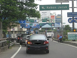
Jalan Daan Mogot is one of the main avenues in Jakarta, Indonesia. The road is named after a military officer involved in the struggle for Indonesian independence Daan Mogot. This road stretches along 27.5 KM from Grogol, West Jakarta to Sukarasa, Tangerang, Tangerang. After entering Tangerang, this road continues to Jalan Merdeka and Jalan Gatot Subroto .This road is part of Indonesian National Route 1. This road crosses 14 urban villages, namely
The Mookervaart River is a canal connecting the Cisadane River in Tangerang and Kali Angke in Jakarta. Constructed from 1678 to 1689, this 25–30 meter wide channel is one of the important flood control water channels in Jakarta.
Cakung River is a river in the Bekasi, West Java, and the eastern part of the Special Capital Region of Jakarta, Indonesia. The lower portions of the original river have been channelized and directed into the eastern flood canal, "Banjir Kanal Timur", which continues to flow to the Java Sea in the district of Marunda, Cilincing, North Jakarta. The river regularly causes flooding in the cities of Bekasi and Jakarta.
Serpong is a district and a sub-district located in South Tangerang, Banten Province, Indonesia. Before South Tangerang City became an autonomous city, Serpong was one of the sub-districts of Tangerang Regency.