
Johar Baru is a district in the administrative city of Central Jakarta, Indonesia. It is roughly bounded by Kampung Rawa Selatan Raya road and Mardani Raya road to the east, Percetakan Negara Raya Road to the south, Letjend Suprapto Road to the north, and a railway line to the west.

Sawah Besar is a district (kecamatan) of Central Jakarta, Indonesia. Its neighborhoods are among the most historic, containing the 1820-established Pasar Baru, the new colonial city – Weltevreden – and the old course of the Ciliwung River. Landmarks include the Lapangan Banteng, the government's 19th century, low-rise A.A. Maramis Building and its high palmed-lawned vista, and Jakarta Cathedral.

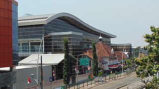
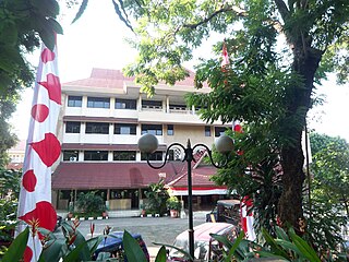
Senen is a long-established urban district of Central Jakarta, Indonesia that has kept many tourist attractions such as two museums, the National Library of Indonesia, Gelanggang Remaja Senen, and narrow alleys with old Chinese and similar style shops and restaurants. It was first developed in the 18th century as Pasar Senen when Governor Daendels established the bovenstad as the new center of government of the fledgling city. Its core remains in what is now the lower-division Senen District, Kwitang, Kenari, Paseban, Kramat, and Bungur. Senen is bounded by a railway line to the east, Ciliwung River to the west, Pramuka Street to the south, and Abdul Rahman Saleh-Kwini II-Senen Raya IV Street to the north. The name is derived from Pasar Senen,.

Ciracas is a district (kecamatan) of East Jakarta, one of the five administrative cities of Jakarta, Indonesia. Ciracas is the southernmost district in Jakarta. The area of Cibubur Scout's camping ground complex is located partly within the Ciracas District, although the main camping ground area is located in Cipayung District. The boundaries of Ciracas District are: Cipinang River to the west, Cipinang River - Jambore Road to the south, Jagorawi Tollroad to the east, and Kelapa Dua Wetan Road to the north.
Jatinegara is one of the districts of the administrative city of East Jakarta, Indonesia. The name also refers to the larger, historic area of the colonial town of Meester Cornelis. Established in the 17th century, Jatinegara is one of the oldest areas in Jakarta, and contains a number of buildings from the colonial period.

Matraman is a district (kecamatan) of East Jakarta, Indonesia. Matraman is the smallest district of East Jakarta. The boundaries of Matraman are: Bekasi Barat Raya Road to the south, Prof Wiyoto Witono MSc Highway to the east, Pramuka Road to the north, and Ciliwung River to the west.
Tebet is a district in the administrative city of South Jakarta, Indonesia. The boundaries of Tebet are Jend. Gatot Subroto-Letjen Haryono MT. tollway to the south, Ciliwung River to the east, Jalan Casablanca - Ciliwung River to the north, and Cideng River to the west. This district is home to SMA Negeri 8 Jakarta
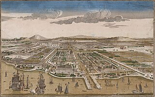
Jakarta is Indonesia's capital and largest city. Located on an estuary of the Ciliwung River, on the northwestern part of Java, the area has long sustained human settlement. Historical evidence from Jakarta dates back to the 4th century CE, when it was a Hindu settlement and port. The city has been sequentially claimed by the Indianized kingdom of Tarumanegara, the Hindu Kingdom of Sunda, the Muslim Sultanate of Banten, and by Dutch, Japanese and Indonesian administrations. The Dutch East Indies built up the area before it was taken during World War II by the Empire of Japan and finally became independent as part of Indonesia.
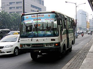
Koperasi Angkutan Jakarta or Kopaja was a cooperative established in 1971 to provide public transport services in Jakarta. There were reportedly over 1,400 minibuses in the Kopaja fleet in mid-2012, more than half of which were estimated to be over 20 years old.
Tanah Tinggi is an administrative village in the Johar Baru district of Indonesia. It has a postal code of 10540.

Pasar Baru is an subdistrict in the Sawah Besar district in Central Jakarta, Indonesia. It has postal code of 10710.
Kwitang is an administrative village (kelurahan) in the subdistrict (kecamatan) of Senen, Central Jakarta. It is one of the historic administrative village of Jakarta. The boundary of Kwitang is the Ciliwung to the west, Jalan Kramat Kwitang to the north, Jalan Kramat Raya to the east, and Jalan Kramat 4 to the south.

The MetroMini minibus system was a major part of the public transport system of Jakarta. There were reportedly over 3,000 buses in the MetroMini fleet in mid-2012. The buses are similar to the parallel Kopaja system which also provides transport services, on different routes, across Jakarta. The distinctive MetroMini buses are orange and blue with a white stripe running along the length of the bus. Buses provide seating for around 20-30 people with, often, an equal number crammed into limited standing room so the buses are often overcrowded. But at 2015 Jakarta Governor Basuki Tjahaja Purnama stopped all of MetroMini's bus operations because of a MetroMini vs KRL Commuter Line crash. If MetroMini wants to operate again, it has to join Transjakarta like the Kopaja as a feeder bus. Many routes are/will replaced/replaced by Minitrans and Metrotrans buses.

Jalan Jenderal Gatot Subroto(Gatot Subroto Avenue) is one of the major roads in Jakarta, Indonesia. The road starts from Dirgantara statue in South Jakarta, which crosses 10 administrative villages and ends at Slipi, Central Jakarta. The road is named after National Hero of Indonesia General Gatot Subroto. The road was constructed in 1960s. The road runs parallel with Jakarta Inner Ring Road. The location of the road is within the Golden Triangle CBD of Jakarta. Many important office buildings and skyscrapers are situated along the road.
Jalan Jenderal Ahmad Yani or Jalan Jend. A. Yani is one of the main roads of Jakarta, Indonesia. The road is named after an Indonesian National Hero General Ahmad Yani. The road was built as a bypass to connect Tanjung Priok harbour with Halim Perdanakusuma Airport in 1960s. This road extends along 5.7 km from Cempaka Mas, Central Jakarta to Pisangan Baru, Matraman, East Jakarta. This road is traversed by Jakarta Inner Ring Road and TransJakarta corridor 10. This road crosses 9 urban villages of Central Jakarta and East Jakarta, namely:

Baru Timur River is a man-made canal flowing from Ci Liwung in Bogor Regency to Jakarta, Indonesia. It was one of two canals built in the 18th century under the order of Governor-General Gustaaf Willem van Imhoff originally to transport agricultural harvest from Bogor to Batavia. Currently, both canals, now known as Kali Baru Timur and Kali Baru Barat, are among the main rivers in Jakarta, and part of the Ciliwung Cisadane flood control project. Baru Timur River flows from the Katulampa flood gate, built at the same time as the canal, along the major road Bogor Highway, passing Cimanggis, Depok, Cilangkap, until reaching the Java Sea in Kali Besar, Tanjung Priok, North Jakarta.

The Cililitan-Tanjung Priok Road, also known as the Jakarta Bypass or simply Bypass, is a 27 km long bypass road in Jakarta, Indonesia that connects the Dewi Sartika Road and the Bogor Main Road in Cililitan, East Jakarta to the Port of Tanjung Priok in North Jakarta. The road is divided into four parts: Jalan Mayjen Sutoyo Road, Jalan D.I. Panjaitan, Jalan Jend. Ahmad Yani Road, and Jalan Laksamana Yos Sudarso. The bypass was inaugurated by the first President of Indonesia, Sukarno on October 21, 1963. One of the Jakarta Inner Ring Road sections is built over the road.

Transjakarta Corridor 14 is a bus rapid transit corridor in Jakarta, Indonesia, operated by Transjakarta. It serves the route from the Jakarta International Stadium to the Senen Raya BRT station, Senen. The streets that passed by Corridor 14 are along Imam Sapi'ie, Letjen Suprapto, Tanah Tinggi Barat/Timur, Utan Panjang Barat/Timur, Kemayoran Gempol, Benyamin Sueb, HBR Motik, and Danau Sunter Barat streets.

