
LeFlore County is a county along the eastern border of the U.S state of Oklahoma. As of the 2010 census, the population was 50,384. Its county seat is Poteau. The county is part of the Fort Smith metropolitan area and the name honors a Choctaw family named LeFlore. The United States District Court for the Eastern District of Oklahoma is the federal district court with jurisdiction in LeFlore County.
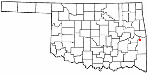
Bokoshe is a town in Le Flore County, Oklahoma, United States. It is part of the Fort Smith, Arkansas-Oklahoma metropolitan statistical area. Bokoshe is a Choctaw word meaning "little creek". The population was 396 at the 2020 census, a 22.3% decrease over the figure of 510 recorded in 2010.

Weleetka is a town in Okfuskee County, Oklahoma, United States. It is approximately 10 miles (16 km) southeast of Okemah, the county seat. The name is a Creek word meaning "running water." The population was 998 at the 2010 census, a decline of 1.6 percent from the figure of 1,014 in 2000.

The Kansas City Southern Railway Company is an American Class I railroad. Founded in 1887, it operates in 10 Midwestern and Southeastern U.S. states: Illinois, Missouri, Kansas, Oklahoma, Arkansas, Tennessee, Alabama, Mississippi, Louisiana and Texas. KCS has the shortest north-south rail route between Kansas City, Missouri, and several key ports along the Gulf of Mexico.

The Texarkana and Fort Smith Railway was the Texas subsidiary of the Kansas City Southern Railway, operating railroad lines in the states of Arkansas and Texas, with headquarters at Texarkana, Texas.

The Arkansas, Louisiana and Mississippi Railroad is a 52.9-mile (85.1 km) short-line railroad in northern Louisiana and southern Arkansas. Opened in 1908, it has undergone several corporate reorganizations, but has remained independent of larger carriers. In 2004, paper producer Georgia-Pacific sold the company to shortline operator Genesee & Wyoming Inc. Traffic generally consists of lumber, paper, forest products, and chemicals.

The Missouri and Northern Arkansas Railroad, LLC is a Class II Regional Railroad in the U.S. states of Missouri, Kansas, and Arkansas. The company is headquartered in Carthage, Missouri. It is not to be confused with the Missouri and North Arkansas Railroad which connected Joplin, Missouri, with Helena, Arkansas, from 1906 to 1946.
The Arkansas Southern Railroad is a short-line railroad which started service in October 2005. ARS operates two disconnected lines consisting of Heavener, Oklahoma to Waldron, Arkansas, and Ashdown to Nashville, Arkansas, plus a switch track at Ashdown, for a total of 63 miles. The lines are leased from Kansas City Southern Railway (KCS) to ARS's owner, the Watco Companies (Watco).
The Oklahoma Railway Company (ORy) operated interurban lines to El Reno, Guthrie, and Norman, and several streetcar lines in Oklahoma City, and the surrounding area from 1904 to 1947.
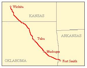
The Midland Valley Railroad (MV) was a railroad company incorporated on June 4, 1903 for the purpose of building a line from Hope, Arkansas, through Muskogee and Tulsa, Oklahoma to Wichita, Kansas. It was backed by C. Jared Ingersoll, a Philadelphia industrialist who owned coal mining properties in Indian Territory. The railroad took its name from Midland, Arkansas, a coal mining town in western Arkansas, which was served by the railroad. The Midland Valley gained access to Fort Smith, Arkansas via trackage rights over the Frisco from Rock Island, Oklahoma.
The Muskogee Company, although a Philadelphia company, was founded in Delaware on February 27, 1923. The company officers were brothers C. Jared Ingersoll, industrialist, as president, and John H. W. Ingersoll, attorney and industrialist, as vice president and treasurer. The Muskogee Company owned large interests in several railroads in and about northeastern Oklahoma.
The Denver, Enid and Gulf Railroad (DE&G) was built as a short line railroad operating in Kansas, and Oklahoma. Incorporated in Oklahoma as the Denver, Enid and Gulf Railroad Company, March 31, 1902, by the five Frantz Brothers.
The following is a brief history of the North American rail system, mainly through major changes to Class I railroads, the largest class by operating revenue.
Vernon is an Incorporated town. Incorporated in 1985 as the "Town of Vernon" in McIntosh County, Oklahoma, United States. Its elevation is 696 feet (212 m).
WFEC Railroad Company-- reporting mark: WFEC-- is a Class III industrial rail line running 14.98 miles from Western Farmers Electric Cooperative's Hugo Power Plant at Fort Towson, Oklahoma, near Hugo, to an interchange with the Texas, Oklahoma and Eastern Railroad (TOE) at Valliant, Oklahoma. It is owned by Western Farmers, and was built in 1997.
The Eastern Oklahoma Railway was incorporated under the laws of Oklahoma Territory on July 24, 1899. The railroad constructed much of its own track. This included Guthrie junction to Cushing junction, 47.9 miles, in the 1900-1902 timeframe; Ripley to Esau Junction, 40.4 miles, also in the 1900-1902 timeframe; Newkirk to Pauls Valley, 182.5 miles, in the 1900-1904 timeframe; and, Davis to Sulphur, 9.3 miles, in 1906.
The Arkansas Western Railway operated a 32-mile rail line between Heavener, Oklahoma and Waldron, Arkansas. It bought the assets of its predecessor in 1904, and the company was merged out of existence in 1992.
The Kansas and Arkansas Valley Railway (“K&AV”) was owner of 170.64 miles of single track, standard gauge steam railroad line, consisting of a 164.63 mile mainline from a junction near Van Buren, Arkansas through Oklahoma to Coffeyville, Kansas, with branch lines of 6.01 miles. It began operations in 1888 and sold its property to the St. Louis, Iron Mountain and Southern Railway in 1909.
The Poteau Valley Railroad was a shortline running from Calhoun, Oklahoma to Shady Point, Oklahoma, encompassing 7.883 mi (12.686 km) of track. It began in 1900 and was abandoned in 1926.
Calhoun, originally called Sutter, is an unincorporated community in Le Flore County in the State of Oklahoma, approximately 7 miles northwest of Poteau, the county seat. Located about 6.5 driving miles west-southwest of Shady Point, Oklahoma, Calhoun can be reached off of US Route 59 at Shady Point by heading west on County Road D1310, then County Road 90. The town is just northwest of Cavanal Hill, which makes the eccentric boast of being the “world’s highest hill.”