Fort Zachary Taylor Historic State Park

Last updated
Fort Zachary Taylor
Aerial view of Fort Zachary Taylor State Park.jpg
Aerial view of Fort Zachary Taylor State Park
USA Florida location map.svg
Red pog.svg
Usa edcp location map.svg
Red pog.svg
Location Monroe County, Florida, USA
Nearest city Key West, Florida
Coordinates 24°32′48″N81°48′38″W / 24.54667°N 81.81056°W / 24.54667; -81.81056
NRHP reference No. 71000244 [1]
Significant dates
Added to NRHPMarch 11, 1971 [1]
Designated NHLMay 31, 1973 [2]

The Fort Zachary Taylor Historic State Park, also known simply as Fort Taylor, is a Florida State Park and National Historic Landmark centered on a Civil War-era fort located near the southern tip of Key West, Florida.

Contents

History

Fort Taylor, Florida by Seth Eastman (1808-1875) Fort taylor.jpg
Fort Taylor, Florida by Seth Eastman (1808-1875)

1845–1900

Construction of the fort began in 1845 as part of a mid-19th century plan to defend the southeast coast of the United States through a series of forts after the War of 1812. Thompson Island, at the southwest tip of Key West, was selected as the site for the fort in 1822 and plans drawn up by Simon Bernard and Joseph G. Totten were approved in 1836. Two supporting artillery batteries, Martello Towers, provided additional coverage, one of which exists today as the Martello Gallery-Key West Art and Historical Museum. The fort was named for United States President Zachary Taylor in November 1850, a few months after his sudden death in office.

The United States Army Corps of Engineers leased slaves from local slave-owners for construction of the fort and its neighbor Fort Jefferson. This resulted in an influx of enslaved peoples into the immediate area as, before the construction of the fort, there were no large agricultural ventures and thus not a high demand for slaves, marine salvage being the main industry. By some estimates, the number more than quadrupled from fewer than 90 enslaved people in Key West before construction to over 400 after. [3]

The fort's foundation consists of oolitic limestone and New England granite. Its 5-foot (1.5 m) thick walls rose 50 feet (15 m) above mean low water and included two tiers of casemates with a terreplein or barbette at the top. Three seaward curtains 495 feet (151 m) between bastions, each containing 42 guns on three levels, were augmented by a land-facing gorge. Troop barracks were built into this gorge with a capacity for 800 men. At either end of the barracks was a large gunpowder magazine while a sally port was located in the center, connected to land by a 1,200-foot (366 m) causeway. Rainwater was collected in underground cisterns along the perimeter of the fort. Yellow fever epidemics and material shortages slowed construction of the fort, which continued throughout the 1850s. The Pensacola, Florida, firm of Raiford and Abercrombie provided bricks for Fort Zachary Taylor and Fort Jefferson, which was under construction at the same time. [4]

Even before the onset of the American Civil War in April 1861, the United States government recognized the importance of holding Fort Taylor if the Southern states seceded. An official report to the United States Secretary of War on December 28, 1860, stated that: "Lieutenant-General Scott will further ask the attention of the Secretary to Forts Jefferson and Taylor, which are wholly national, being of far greater value even to the most distant points of the Atlantic coast...than to the State of Florida. There is only a feeble company at Key West for the defense of Fort Taylor." [5] At midnight on January 13, 1861, Union Captain John Milton Brannan moved his 44 men of the 1st U.S. Artillery Regiment from Key West Barracks to Fort Taylor. Despite having no orders to do so, Captain Brannan took the initiative in manning the fort to prevent it from falling into Confederate hands. [6] It became a key outpost for threatening blockade runners during the Union blockade. Major William H. French arrived in April 1861 with his artillery unit. [7]

In 1898, the fort was reduced to two stories and Battery Osceola was added to the south casemate. The battery consisted of two 12-inch M1895 guns. The Civil War-era guns were used as fill, being buried within the new battery to save on materials. Battery Adair was added to the west casemate and included four 3-inch M1898 15-pounder rapid-fire rifles. [4]

The fort was heavily used again during the Spanish–American War (1898), World War I (1917–1918), World War II (1941–1945), and the Cuban Missile Crisis (1962).

Fort Zachary Taylor Parade Ground as seen from Battery Osceola, with the Civil War barracks on the right, the North Curtain rooms in the background, and Battery Adair on the left. Key West FL Fort Zachary Taylor05.jpg
Fort Zachary Taylor Parade Ground as seen from Battery Osceola, with the Civil War barracks on the right, the North Curtain rooms in the background, and Battery Adair on the left.

1947–present

No longer of use to the U.S. Army, the fort was turned over to the United States Navy in 1947 for maintenance. In 1968, volunteers led by Howard S. England excavated Civil War guns and ammunition buried in long-abandoned parts of the fort to form what would be considered the nation's largest collection of Civil War cannons. Fort Taylor was placed on the National Register of Historic Places in 1971 and designated a National Historic Landmark in 1973. Due to the filling in of land around the fort, including the creation of an attractive stretch of beach, the park now occupies 87 acres (35 ha).

Truman Annex

The fort's land closer to downtown Key West became part of the Truman Annex to Naval Air Station Key West. It was originally a separate major installation known as Naval Station Key West and, until it closed in 1974, included a submarine base.

President Harry S. Truman used Naval Station Key West as his Winter White House for a total of 175 days over 11 visits. The United States Secret Service had a private beach (eventually named after Truman) built on the land for Truman's security, but he reportedly only visited it once, preferring the public beaches.

Naval Station Key West was decommissioned in 1974 as part of post-Vietnam War force reductions because the U.S. Navy had decommissioned nearly all of its diesel-electric submarines and nuclear-powered submarines were too large for the naval station's port. Most of the former naval station became an annex (the Truman Annex) to Naval Air Station (NAS) Key West and served as the landing point for many Cubans during the 1980 Mariel boatlift of Cuban refugees. Those buildings in the Truman Annex and associated real estate not retained by the Navy as part of NAS Key West were sold to private developers. A museum for the Truman White House was built and the Navy continues to own and maintain the piers and that portion of the former Naval Station Key West property to the south of Fort Taylor, which it uses primarily to support of Joint Interagency Task Force South (JIATF-S). The site also supported Naval Security Group Activity Key West (NAVSECGRUACT KEY WEST) until NAVSECGRUACT's decommissioning in 1996. [8]

Current uses

In addition to the role of the fort and its adjacent beach as tourist attractions, Fort Taylor is also the location of a number of annual events, including week-long Civil War reenactments.

Related Research Articles

<span class="mw-page-title-main">Key West</span> Island and city in Florida, United States

Key West is an island in the Straits of Florida, within the U.S. state of Florida. Together with all or parts of the separate islands of Dredgers Key, Fleming Key, Sunset Key, and the northern part of Stock Island, it constitutes the City of Key West.

<span class="mw-page-title-main">Fort Wool</span> Historic island fortification in Virginia

Fort Wool is a decommissioned island fortification located in the mouth of Hampton Roads, adjacent to the Hampton Roads Bridge-Tunnel (HRBT). Officially known as Rip Raps Island, the fort has an elevation of 7 feet and sits near Old Point Comfort, Old Point Comfort Light, Willoughby Beach and Willoughby Spit, approximately one mile south of Fort Monroe.

<span class="mw-page-title-main">Fort William and Mary</span> United States historic place

Fort William and Mary was a colonial fortification in Britain's worldwide system of defenses, defended by soldiers of the Province of New Hampshire who reported directly to the royal governor. The fort, originally known as "The Castle," was situated on the island of New Castle, New Hampshire, at the mouth of the Piscataqua River estuary. It was renamed Fort William and Mary circa 1692, after the accession of the monarchs William III and Mary II to the British throne. It was captured by Patriot forces, recaptured, and later abandoned by the British in the Revolutionary War. The fort was renamed Fort Constitution in 1808 following rebuilding. The fort was further rebuilt and expanded through 1899 and served actively through World War II.

<span class="mw-page-title-main">Fort Pickens</span> Historic United States military fort on Santa Rosa Island, Pensacola, Florida

Fort Pickens is a pentagonal historic United States military fort on Santa Rosa Island in the Pensacola, Florida, area. It is named after American Revolutionary War hero Andrew Pickens. It is the largest of four forts built to defend Pensacola Bay and its navy yard. The fort was completed in 1834 and was one of the few forts in the South that remained in Union hands throughout the American Civil War. It remained in use until 1947. Fort Pickens is included within the Gulf Islands National Seashore, and as such, is administered by the National Park Service.

<span class="mw-page-title-main">Fort McRee</span> Former fort near Pensacola, Florida

Fort McRee was a historic military fort constructed by the United States on the eastern tip of Perdido Key to defend Pensacola and its important natural harbor. In the defense of Pensacola Bay, Fort McRee was accompanied by Fort Pickens, located across Pensacola Pass on Santa Rosa Island, and Fort Barrancas, located across Pensacola Bay on the grounds of what is now Naval Air Station (NAS) Pensacola. Fort Pickens was the largest of these. Very little remains of Fort McRee today.

<span class="mw-page-title-main">Coalhouse Fort</span> Artillery fort at Coalhouse Point in Essex, England

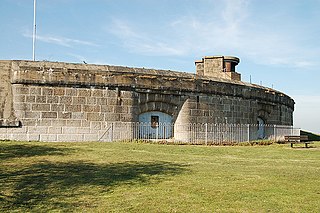
Coalhouse Fort is an artillery fort in the eastern English county of Essex. It was built in the 1860s to guard the lower Thames from seaborne attack. It stands at Coalhouse Point on the north bank of the river, at a location near East Tilbury which was vulnerable to raiders and invaders. It was the last in a series of fortifications dating back to the 15th century and was the direct successor to a smaller mid-19th century fort built on the same site. Constructed during a period of tension with France, its location on marshy ground caused problems from the start and led to a lengthy construction process. The fort was equipped with a variety of large-calibre artillery guns and the most modern defensive facilities of the time, including shell-proof casemates protected by granite facing and cast-iron shields. Its lengthy construction and the rapid pace of artillery development at the time meant that it was practically obsolete for its original purpose within a few years of its completion.

<span class="mw-page-title-main">Fort Mifflin</span> Fort on the Delaware River below Philadelphia, Pennsylvania

Fort Mifflin, originally called Fort Island Battery and also known as Mud Island Fort, was commissioned in 1771 and sits on Mud Island on the Delaware River below Philadelphia, Pennsylvania near Philadelphia International Airport.

<span class="mw-page-title-main">Manchester State Park (Washington)</span> State park in Washington (state), United States

Manchester State Park is a 111-acre (45 ha) state park in Kitsap County, Washington, United States. It is situated on the east side of the Kitsap Peninsula with 3,400 feet (1,000 m) of shoreline facing Puget Sound. It was at one time a harbor defense installation for the nearby Bremerton, then a fuel supply depot and U.S. Navy fire-fighting station. The park contains a former torpedo warehouse, a mining casement, and a gun battery. Park activities include picnicking, camping, boating, fishing, hiking on 1.9 miles (3.1 km) of trails, birdwatching, volleyball, wildlife viewing, and horseshoes.

<span class="mw-page-title-main">Truman Annex</span>

Truman Annex is both a neighborhood and military installation in Key West, Florida, United States. It is the part of the island that is west of Whitehead Street, with the exception of Bahama Village. It is where the winter White House for President Harry S. Truman is located from its days as part of the former Naval Station Key West. The Harry S. Truman Little White House in Key West, Florida was the winter White House for President Truman for 175 days during 11 visits.

<span class="mw-page-title-main">Naval Air Station Key West</span> United States military installation

Naval Air Station Key West, is a naval air station and military airport located on Boca Chica Key, four miles (6 km) east of the central business district of Key West, Florida, United States.

<span class="mw-page-title-main">Fort Tilden</span> Historic military installation in Queens, New York

Fort Tilden, also known as Fort Tilden Historic District, is a former United States Army installation on the coast in the New York City borough of Queens. Fort Tilden now forms part of the Gateway National Recreation Area, and is administered by the National Park Service.

<span class="mw-page-title-main">John Milton Brannan</span>

John Milton Brannan was a career United States Army artillery officer who served in the Mexican–American War and as a Union brigadier general of volunteers in the American Civil War, in command of the Department of Key West in Florida and assigned to Fort Zachary Taylor. Most notably, he served as a division commander of the Union XIV Corps at the Battle of Chickamauga.

<span class="mw-page-title-main">Fort Funston</span>

Fort Funston is a former harbor defense installation located in the southwestern corner of San Francisco. Formerly known as the Lake Merced Military Reservation, the fort is now a protected area within the Golden Gate National Recreation Area (GGNRA) and is used widely as an off-leash dog park. It was named in honor of Frederick N. Funston (1865–1917), a Major General in the United States Army with strong connections to San Francisco, and included several artillery batteries. The fort is located on Skyline Boulevard at John Muir Drive, west of Lake Merced.

<span class="mw-page-title-main">Howard S. England</span>

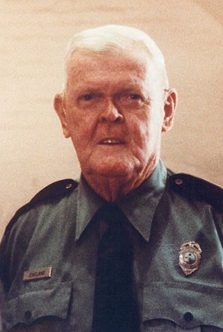
Howard S. England, was the principal individual responsible for the transformation of Fort Zachary Taylor from a forgotten eyesore to a popular historic landmark and state park in Key West, Florida.

<span class="mw-page-title-main">Fort Jefferson (Florida)</span> United States historic place

Fort Jefferson is a former U.S. military coastal fortress in the Dry Tortugas National Park of Florida. It is the largest brick masonry structure in the Americas, covering 16 acres (6.5 ha) and made with over 16 million bricks. Among United States forts, only Fort Monroe in Virginia and Fort Adams in Rhode Island are larger. The fort is located on Garden Key in the lower Florida Keys within the Dry Tortugas, 68 miles (109 km) west of the island of Key West. The Dry Tortugas are part of Monroe County in Florida.

<span class="mw-page-title-main">Ichabod Crane (colonel)</span>

Ichabod Bennet Crane was an American career military officer for 48 years and the probable namesake of the protagonist in Washington Irving's The Legend of Sleepy Hollow.

<span class="mw-page-title-main">Fort Hommet</span>

Fort Hommet is a fortification on Vazon Bay headland in Castel, Guernsey. It is built on the site of fortifications that date back to 1680 and consists of a Martello tower from 1804, later additions during the Victorian Era, and bunkers and casemates that the Germans constructed during World War II.

<span class="mw-page-title-main">Fort Foster (Kittery, Maine)</span>

Fort Foster, now part of Fort Foster Park, is a historic fort active 1901–1946 on the southwest tip of Gerrish Island in the Kittery Point area of Kittery, Maine. The park includes beaches and trails. Battery Bohlen and Battery Chapin were the major parts of the fort.

The Harbor Defenses of Portsmouth was a United States Army Coast Artillery Corps harbor defense command. It coordinated the coast defenses of Portsmouth, New Hampshire and the nearby Portsmouth Naval Shipyard in Kittery, Maine from 1900 to 1950, both on the Piscataqua River, beginning with the Endicott program. These included both coast artillery forts and underwater minefields. The command originated circa 1900 as the Portsmouth Artillery District, was renamed Coast Defenses of Portsmouth in 1913, and again renamed Harbor Defenses of Portsmouth in 1925.

References

  1. 1 2 "National Register Information System". National Register of Historic Places . National Park Service. March 13, 2009.
  2. Fort Zachary Taylor Archived 2009-05-02 at the Wayback Machine at National Historic Landmarks Program Archived September 27, 2007, at the Wayback Machine
  3. Smith, Mark A. (Spring 2008). "Engineering Slavery: The U.S. Army Corps of Engineers and Slavery at Key West". The Florida Historical Quarterly. 86 (4): 60–63. Retrieved 31 August 2022.
  4. 1 2 England, Howard (2015). Fort Zachary Taylor. England Historical Enterprises LLC. pp. 5–9, 14. ISBN   9780991386536.
  5. United States War Department (1894). The War of the Rebellion: A Compilation of the Official Records of the Union and Confederate Armies. Govt. Print. Off. p. 112. hdl:2027/coo.31924077725913 . Retrieved 6 September 2022.
  6. Burnett, Gene M. (1988). Florida's past : people and events that shaped the state. Volume 2. Sarasota, FL: Pineapple Press. p. 122. ISBN   9780910923590.
  7. Reid, Thomas. America's Fortress. Gainesville: University Press of Florida. p. 34,42. ISBN   9780813030197.
  8. "21 Years Ago Today NSGA Key West was Disestablished". Station HYPO. 31 August 2017. Retrieved July 10, 2018.