Geography of Djibouti

Last updated
Geography of Djibouti
The geography of the Republic of Djibouti.png

LocationDjibouti.svg
Continent Africa
Region Horn of Africa
Area Ranked 146th
  Total23,200 km2 (9,000 sq mi)
Coastline314 km (195 mi)
Borders575 km (357 mi)
* Flag of Ethiopia.svg  Ethiopia: 390 km (242 mi)
* Flag of Eritrea.svg  Eritrea: 125 km (78 mi)
* Flag of Somalia.svg  Somalia: 60 km (37 mi)
* Flag of Yemen.svg  Yemen: (maritime boundary, Bab el Mandeb)
Highest point Mousa Ali
2,028 m (6,654 ft)
Lowest point Lac Assal
−155 m (−509 ft)
Largest lake Lake Abbe
TerrainMostly mountainous and volcanic

Djibouti is a country in the Horn of Africa. It is bordered by Eritrea in the north, Ethiopia in the west and south, and Somalia in the southeast. To the east is its coastline on the Red Sea and the Gulf of Aden. Rainfall is sparse, and most of the territory has a semi-arid to arid environment. Lake Assal is a saline lake which lies 155 m (509 ft) below sea level, making it the lowest point on land in Africa and the third-lowest point on Earth after the Sea of Galilee and the Dead Sea. Djibouti has the fifth smallest population in Africa. Djibouti's major settlements include the capital Djibouti City, the port towns of Tadjoura and Obock, and the southern cities of Ali Sabieh and Dikhil. It is the forty-six country by area in Africa and 147st largest country in the world by land area, covering a total of 23,200 km2 (9,000 sq mi), of which 23,180 km2 (8,950 sq mi) is land and 20 km2 (7.7 sq mi) is water. [1]

Contents

Location

Djibouti shares 125 kilometres (78 mi) of border with Eritrea, 390 kilometres (240 mi) with Ethiopia, and 60 kilometres (37 mi) with Somalia (total 575 km or 357 mi). It has a strategic location on the Horn of Africa and the Bab el Mandeb, along a route through the Red Sea and Suez Canal. Djibouti's coastline serves as a commercial gateway between the Arabian Peninsula and the Horn region's interior. The country is also the terminus of rail traffic into Ethiopia.

Physiographic regions

Djibouti can be divided into three physiographic regions

  1. The Northern Mountains
  2. Grand Bara
  3. The Southern Mountains
The Goda Mountains Goda Mountains - National Park of Foret du Day.jpg
The Goda Mountains

Mountains

A great arc of mountains, consisting of the Mousa Ali, Goda Mountains, and Arrei Mountains surrounds Djibouti.

Djibouti has eight mountain ranges with peaks of over 1,000 m (3,281 ft). [2]

Grand Bara

The Grand Bara Desert Baadha Wayn (Grand Bara).jpg
The Grand Bara Desert

The Grand Bara Desert covers parts of southern Djibouti in the Arta Region, Ali Sabieh Region and Dikhil Region. The majority of the Grand Bara Desert lies at a relatively low elevation, below 1,700 feet (560 m). Home of the popular Grand Bara footrace.

Coasts

Most of Djibouti has been described as part of the Ethiopian xeric grasslands and shrublands ecoregion. The exception is a strip along the Red Sea coast, which is part of the Eritrean coastal desert; it is noted as an important migration route for birds of prey. [3]

Map of the regions of Djibouti. Djiboutimap.png
Map of the regions of Djibouti.

Regions

The area of the regions of Djibouti is set out in the table below.

The rainfall of Djibouti Rainfall Of Djibouti.png
The rainfall of Djibouti
RankNameArea
1 Dikhil Region 7,200 km2
2 Tadjourah Region 7,100 km2
3 Obock Region 4,700 km2
4 Ali Sabieh Region 2,200 km2
5 Arta Region 1,800 km2
6 Djibouti Region 200 km2

Climate

There is not much seasonal variation in Djibouti's climate. Hot conditions prevail year-round along with winter rainfall. Mean daily maximum temperatures range from 32 to 41 °C (90 to 106 °F), except at high elevations. In Djibouti City, for instance, afternoon highs in April typically range from 28 °C (82 °F) to 34 °C (93 °F) in April. Nationally, mean daily minima generally vary between sites from about 15 to 30 °C (59 to 86 °F). The greatest range in climate occurs in eastern Djibouti, where temperatures sometimes surpass 41 °C (106 °F) in July on the littoral plains and fall below freezing point during December in the highlands. In this region, relative humidity ranges from about 40% in the mid-afternoon to 85% at night, changing somewhat according to the season.

Koppen climate types of Djibouti Djibouti's map of Koppen climate classification.png
Köppen climate types of Djibouti

Djibouti has 988,000 people living there. Djibouti has either a hot semi-arid climate (BSh) or a hot desert climate (BWh), although temperatures are much moderated at the high elevations. On the coastal seaboard, annual rainfall is less than 5 inches (131 mm); in the highlands, it is about 8 to 16 inches (200 to 400 mm).[ citation needed ] Although the coastal regions are hot and humid throughout the year, the hinterland is typically hot and dry. The climate conditions are highly variable within the country and vary locally by altitude.[ citation needed ] Summers are very humid along the coast but dry in the highlands. Heat waves are frequent. Annual precipitation amounts vary greatly from one year to another. In general, rain falls more frequently and extensively in the mountains.[ citation needed ] Sudden and brutal storms are also known to occur. Wadis turn for a few hours into raging torrents tearing everything in their path, and their course is regularized[ clarification needed ]. Rainwater serves as an additional water supply for livestock and plants alongside seasonal watercourses. The highlands have temperate climate throughout the year. The climate of most lowland zones is arid and semiarid.

The climate of the interior shows notable differences from the coastline. Especially in the mornings, the temperature is pleasant: it is so in Arta, Randa and Day (where temperatures of 10 degrees Celsius have been recorded).

Climate charts of different locations in Djibouti

Djibouti City
Climate chart (explanation)
J
F
M
A
M
J
J
A
S
O
N
D
 
 
10
 
 
29
22
 
 
19
 
 
29
23
 
 
20
 
 
30
24
 
 
29
 
 
32
25
 
 
17
 
 
35
27
 
 
0.1
 
 
39
29
 
 
6.2
 
 
42
31
 
 
5.6
 
 
41
31
 
 
3.1
 
 
37
29
 
 
20
 
 
33
26
 
 
22
 
 
31
23
 
 
11
 
 
29
22
Average max. and min. temperatures in °C
Precipitation totals in mm
Source: Deutscher Wetterdienst
Imperial conversion
JFMAMJJASOND
 
 
0.4
 
 
84
71
 
 
0.7
 
 
84
73
 
 
0.8
 
 
86
75
 
 
1.1
 
 
90
78
 
 
0.7
 
 
95
81
 
 
0
 
 
102
85
 
 
0.2
 
 
107
88
 
 
0.2
 
 
106
87
 
 
0.1
 
 
99
84
 
 
0.8
 
 
92
78
 
 
0.9
 
 
87
74
 
 
0.4
 
 
85
71
Average max. and min. temperatures in °F
Precipitation totals in inches
Arta
Climate chart (explanation)
J
F
M
A
M
J
J
A
S
O
N
D
 
 
30
 
 
25
15
 
 
27
 
 
26
17
 
 
26
 
 
27
18
 
 
30
 
 
28
20
 
 
16
 
 
29
21
 
 
1
 
 
33
24
 
 
9
 
 
36
26
 
 
20
 
 
36
25
 
 
10
 
 
32
23
 
 
12
 
 
28
20
 
 
43
 
 
27
18
 
 
12
 
 
26
15
Average max. and min. temperatures in °C
Precipitation totals in mm
Source: Levoyageur
Imperial conversion
JFMAMJJASOND
 
 
1.2
 
 
77
59
 
 
1.1
 
 
79
62
 
 
1
 
 
80
65
 
 
1.2
 
 
83
68
 
 
0.6
 
 
85
71
 
 
0
 
 
92
75
 
 
0.4
 
 
97
78
 
 
0.8
 
 
96
77
 
 
0.4
 
 
89
74
 
 
0.5
 
 
82
68
 
 
1.7
 
 
80
64
 
 
0.5
 
 
79
60
Average max. and min. temperatures in °F
Precipitation totals in inches
Holhol
Climate chart (explanation)
J
F
M
A
M
J
J
A
S
O
N
D
 
 
5
 
 
26
17
 
 
9
 
 
27
18
 
 
25
 
 
29
20
 
 
37
 
 
31
21
 
 
14
 
 
35
23
 
 
7
 
 
39
26
 
 
11
 
 
39
28
 
 
35
 
 
36
28
 
 
29
 
 
34
26
 
 
13
 
 
30
22
 
 
7
 
 
28
19
 
 
6
 
 
27
17
Average max. and min. temperatures in °C
Precipitation totals in mm
Source: Climate-Data
Imperial conversion
JFMAMJJASOND
 
 
0.2
 
 
80
63
 
 
0.4
 
 
81
65
 
 
1
 
 
85
68
 
 
1.5
 
 
88
71
 
 
0.6
 
 
94
74
 
 
0.3
 
 
102
78
 
 
0.4
 
 
102
83
 
 
1.4
 
 
97
82
 
 
1.1
 
 
92
78
 
 
0.5
 
 
87
72
 
 
0.3
 
 
82
67
 
 
0.2
 
 
81
63
Average max. and min. temperatures in °F
Precipitation totals in inches
Ali Sabieh
Climate chart (explanation)
J
F
M
A
M
J
J
A
S
O
N
D
 
 
17
 
 
26
15
 
 
14
 
 
27
17
 
 
15
 
 
27
18
 
 
21
 
 
28
20
 
 
5
 
 
29
21
 
 
2
 
 
33
24
 
 
19
 
 
36
25
 
 
43
 
 
36
25
 
 
34
 
 
32
23
 
 
10
 
 
28
20
 
 
13
 
 
27
18
 
 
7
 
 
26
15
Average max. and min. temperatures in °C
Precipitation totals in mm
Source: Climate-Data
Imperial conversion
JFMAMJJASOND
 
 
0.7
 
 
79
59
 
 
0.6
 
 
80
62
 
 
0.6
 
 
81
65
 
 
0.8
 
 
82
68
 
 
0.2
 
 
85
71
 
 
0.1
 
 
92
75
 
 
0.7
 
 
97
77
 
 
1.7
 
 
96
77
 
 
1.3
 
 
89
74
 
 
0.4
 
 
82
68
 
 
0.5
 
 
80
64
 
 
0.3
 
 
79
60
Average max. and min. temperatures in °F
Precipitation totals in inches
Dikhil
Climate chart (explanation)
J
F
M
A
M
J
J
A
S
O
N
D
 
 
7
 
 
27
17
 
 
8
 
 
27
19
 
 
10
 
 
28
20
 
 
28
 
 
28
22
 
 
9
 
 
31
23
 
 
3
 
 
36
26
 
 
29
 
 
38
28
 
 
41
 
 
38
27
 
 
38
 
 
34
26
 
 
8
 
 
29
22
 
 
6
 
 
28
19
 
 
2
 
 
28
18
Average max. and min. temperatures in °C
Precipitation totals in mm
Source: Climate-Data
Imperial conversion
JFMAMJJASOND
 
 
0.3
 
 
81
63
 
 
0.3
 
 
81
66
 
 
0.4
 
 
82
68
 
 
1.1
 
 
83
71
 
 
0.4
 
 
88
74
 
 
0.1
 
 
96
78
 
 
1.1
 
 
101
82
 
 
1.6
 
 
100
81
 
 
1.5
 
 
93
78
 
 
0.3
 
 
85
72
 
 
0.2
 
 
83
67
 
 
0.1
 
 
82
64
Average max. and min. temperatures in °F
Precipitation totals in inches
Airolaf
Climate chart (explanation)
J
F
M
A
M
J
J
A
S
O
N
D
 
 
34
 
 
24
9
 
 
37
 
 
24
10
 
 
33
 
 
25
12
 
 
45
 
 
26
13
 
 
24
 
 
27
15
 
 
13
 
 
30
17
 
 
49
 
 
31
19
 
 
70
 
 
31
18
 
 
56
 
 
29
17
 
 
16
 
 
27
13
 
 
32
 
 
25
11
 
 
22
 
 
24
9
Average max. and min. temperatures in °C
Precipitation totals in mm
Source: Climate-Data
Imperial conversion
JFMAMJJASOND
 
 
1.3
 
 
75
49
 
 
1.5
 
 
76
51
 
 
1.3
 
 
77
53
 
 
1.8
 
 
79
56
 
 
0.9
 
 
81
59
 
 
0.5
 
 
86
63
 
 
1.9
 
 
88
66
 
 
2.8
 
 
87
65
 
 
2.2
 
 
85
62
 
 
0.6
 
 
80
56
 
 
1.3
 
 
78
52
 
 
0.9
 
 
75
49
Average max. and min. temperatures in °F
Precipitation totals in inches
Alaili Dadda
Climate chart (explanation)
J
F
M
A
M
J
J
A
S
O
N
D
 
 
10
 
 
28
20
 
 
11
 
 
28
20
 
 
13
 
 
30
22
 
 
11
 
 
32
23
 
 
6
 
 
35
26
 
 
2
 
 
37
28
 
 
13
 
 
38
28
 
 
19
 
 
37
27
 
 
17
 
 
36
27
 
 
7
 
 
33
24
 
 
14
 
 
30
22
 
 
12
 
 
28
21
Average max. and min. temperatures in °C
Precipitation totals in mm
Source: Climate-Data
Imperial conversion
JFMAMJJASOND
 
 
0.4
 
 
82
67
 
 
0.4
 
 
82
69
 
 
0.5
 
 
85
71
 
 
0.4
 
 
89
74
 
 
0.2
 
 
94
78
 
 
0.1
 
 
99
83
 
 
0.5
 
 
101
82
 
 
0.7
 
 
99
81
 
 
0.7
 
 
96
81
 
 
0.3
 
 
91
75
 
 
0.6
 
 
86
71
 
 
0.5
 
 
82
70
Average max. and min. temperatures in °F
Precipitation totals in inches
Yoboki
Climate chart (explanation)
J
F
M
A
M
J
J
A
S
O
N
D
 
 
6
 
 
30
21
 
 
6
 
 
30
22
 
 
3
 
 
32
24
 
 
10
 
 
34
25
 
 
4
 
 
38
28
 
 
3
 
 
40
30
 
 
45
 
 
40
28
 
 
55
 
 
39
28
 
 
26
 
 
38
29
 
 
2
 
 
35
25
 
 
4
 
 
32
22
 
 
4
 
 
30
21
Average max. and min. temperatures in °C
Precipitation totals in mm
Source: Climate-Data
Imperial conversion
JFMAMJJASOND
 
 
0.2
 
 
86
69
 
 
0.2
 
 
86
72
 
 
0.1
 
 
90
74
 
 
0.4
 
 
94
77
 
 
0.2
 
 
100
82
 
 
0.1
 
 
105
86
 
 
1.8
 
 
105
83
 
 
2.2
 
 
103
82
 
 
1
 
 
100
84
 
 
0.1
 
 
94
77
 
 
0.2
 
 
89
72
 
 
0.2
 
 
86
70
Average max. and min. temperatures in °F
Precipitation totals in inches

Graphically the seasons can be represented this way:

MonthDecJanFebMarAprMayJunJulAugSepOctNov
SeasonWinter|JilaalSummer/HagaaWinter|Jilaal
TemperatureCoolVery HotCool

Selected elevations of notable locations

The Arrei Mountains as seen from Ali Sabieh. Arrei Mountains see from Ali Sabieh.JPG
The Arrei Mountains as seen from Ali Sabieh.
The Southern part of the Boura Mountains. Southern part of the Boura Mountains.jpg
The Southern part of the Boura Mountains.
LocationRegionElevation
(feet)
Elevation
(metres)
Mousa Ali Tadjourah 6,631 ft2,028 m
Goda Mountains Tadjourah 5,840 ft1,780 m
Garbi Tadjourah 5,512 ft1,680 m
Yaguer Dikhil 4,524 ft1,379 m
Mabla Mountains Obock 4,511 ft1,375 m
Arrei Mountains Ali Sabieh 4,268 ft1,301 m
Dagouein Mountain Ali Sabieh 3,688 ft1,124 m
Hemed Arta 3,619 ft1,103 m
Boura Mountains Ali Sabieh 3,291 ft1,003 m
Arta Mountains Arta 2,477 ft755 m
Lake Assal Tadjourah  – 509 ft – 155 m

Lake Assal is the lowest point in Africa.

Resources and land use

Grazing camel in Ali Sabieh Region. Grazing camel in Ali Sabieh Region.jpg
Grazing camel in Ali Sabieh Region.

Land use:arable land: 0.1%
permanent pasture: 73.3%
forest: 0.2%
other: 26.4% (2011)

Irrigated land:10 km2 (3.86 sq mi) (2012)

Water in Djibouti

Water is becoming a scarce resource in Djibouti due to climate change, which leads to different rainfall patterns as well as to inefficient methods of distribution within the country. Most of Djibouti's rainfall is in the four months, but over the last 25 years, the Djibouti's Ministry of Environment estimates that rainfall has decreased overall between 5 and 20 percent. It is predicted that in future years, there will be higher temperatures, lower rainfall, and longer droughts, leading to even less access to water. Moreover, seawater intrusion or fossil saltwater contamination of the limited freshwater aquifers due to groundwater overexploitation affect those who live close to the coastline. [4]

In recent years[ when? ], population growth has increased rapidly with the addition of many refugees.

Natural resources

Unlike much of the Horn of Africa and Middle East which is rich in lucrative crude oil, Djibouti has limited natural resources. These include potential geothermal power, gold, clay, granite, limestone, marble, salt, diatomite, gypsum, pumice, petroleum.

Environment

Natural hazards include earthquakes, drought, and occasional cyclonic disturbances from the Indian Ocean, which bring heavy rains, and flash floods. Natural resources include geothermal energy. Inadequate supplies of potable water, limited arable land and desertification are current issues.

Djibouti is a party to international agreements on biodiversity, climate change, desertification, endangered species, Law of the Sea, ozone layer protection, ship pollution, and wetlands.

Coastline

The Republic of Djibouti Maritime Borders. Republic of Djibouti Maritime Borders.png
The Republic of Djibouti Maritime Borders.

Djibouti has a coastline which measures about 314 kilometres (195 mi). Much of the coastline is accessible and quite varied in geography and habitats.

Inlets

Maritime claims

Human geography

Satellite images of Djibouti during the night. Satellite images of Djibouti during the night.png
Satellite images of Djibouti during the night.

The population of Djibouti in 2015 was 846,000.

For statistical purposes, the country has three areas; Djibouti City (population 529,000), Ali Sabieh (population 55,000), and Dikhil (population 54,000). Djibouti's population is diverse demographically; 60% Somali, 35% Afar, and 3% Arabs. In terms of religion, 94% Muslim, 6% Christian.

Extreme points

This is a list of the extreme points of Djibouti, the points that are farther north, south, east or west than any other location.

Related Research Articles

<span class="mw-page-title-main">Geography of Eritrea</span> Overview of geography in Eritrea

Eritrea is located in the Horn of Africa and is bordered on the northeast and east by the Red Sea, on the west and northwest by Sudan, on the south by Ethiopia, and on the southeast by Djibouti. The country has a high central plateau that varies from 1,800 to 3,000 meters (5,906–9,843 ft) above sea level. A coastal plain, western lowlands, and some 350 islands comprise the remainder of Eritrea's land mass.

<span class="mw-page-title-main">Tadjourah Region</span> Region of Djibouti

The Tadjourah Region Somali: Gobolka Tajoora, Afar: Rakaakay Tagórri) is a region in north-central Djibouti, the largest of its six regions. With its capital at Tadjourah, it has an area of 7,100 square kilometres. It lies along the Gulf of Tadjoura, and the coastal city of Tadjoura. The region has active salt and fisheries industries, and is served by the Tadjoura Airport. In total area, it is larger than Brunei and smaller than Cyprus.

<span class="mw-page-title-main">Obock Region</span> Region of Djibouti

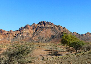
The Obock Region is a region in northern Djibouti. It has a land area of 4,700 square kilometres, and had a population of 37,856 in 2009. It lies along the Red Sea, Bab-el-Mandeb, Gulf of Aden, Gulf of Tadjoura and includes the Seven Brothers, Doumeira Islands and the coastal city of Obock. It lies along a portion of the national border with Eritrea. In total area, it is larger than Cape Verde and smaller than Trinidad and Tobago. The topography of the region has highland and coastal plains.

<span class="mw-page-title-main">Dikhil Region</span> Region of Djibouti

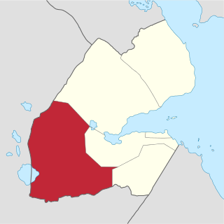
The Dikhil Region is a region in southern Djibouti. It is bordered by the Regions of Tadjoura to the north, Arta to the northeast, Ali Sabieh to the east. To the west and south, it has a long line with the Djibouti-Ethiopia border adjacent to the Ethiopia Regions of Afar Region and Somali Region. Dikhil Region is the largest Region in Djibouti by area, with a mainland area of 7,200 square kilometres, it is about the same size as Sikkim. The Dikhil Region's capital is the town of Dikhil.

<span class="mw-page-title-main">Ali Sabieh Region</span> Region in Djibouti

Ali Sabieh Region is a region in southern Djibouti. With a mainland area of 2,400 square kilometres, it lies along the national border with Somaliland and Ethiopia, bordering also the Dikhil Region to the west and the Arta Region to the north. Its capital is Ali Sabieh. The Arrei Mountains are the highest point in the region.

<span class="mw-page-title-main">Arta Region</span> Region of Djibouti

Arta Region is one of the six regions of Djibouti. It was officially created in 2003 by the regrouping of districts of the regions of Dikhil and Djibouti. It is situated in the south-central of the country, bordering the Tadjoura Region to the north, and the Djibouti Region to the north-east, and Dikhil Region the Ali Sabieh Region to the south, the country of Somaliland lies to the east.

<span class="mw-page-title-main">Tadjoura</span> Town in Djibouti

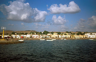
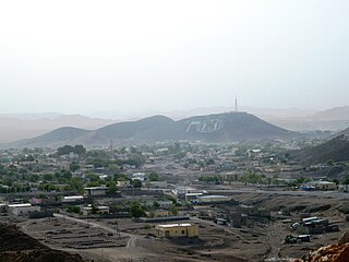
Tadjoura is one of the oldest towns in Djibouti and the capital of the Tadjourah Region. The town evolved into an early Islamic center with the arrival of Muslims shortly after the Hijra. An important port for many centuries, it was ruled by a succession of polities, including the Ifat Sultanate, Adal Sultanate, the Ottoman Empire, France until Djibouti's independence in 1977. Lying on the Gulf of Tadjoura, it is home to a population of around 45,000 inhabitants. It is the third-largest city in the country after Djibouti and Ali Sabieh.

<span class="mw-page-title-main">Dikhil</span> Town in Djibouti

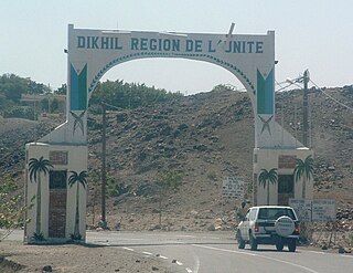
Dikhil is a town in the western Dikhil Region of Djibouti. Lying east of Lake Abbe, It is situated about 122 km (76 mi) southwest of Djibouti City and 12 km (7.5 mi) north of the border with Ethiopia. It serves as the administrative centre of the Dikhil Region, and is home to the Afar and Somali ethnic groups. The town develops gardens and fruit trees.

<span class="mw-page-title-main">Districts of Djibouti</span>

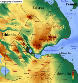
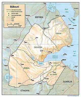
Djibouti is divided into five administrative regions and one city. The regions are divided into twenty administrative districts.

<span class="mw-page-title-main">Ali Sabieh</span> City in Djibouti

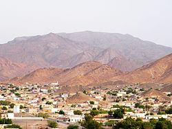
Ali Sabieh is the second largest city in Djibouti. It is situated about 98 kilometres Southwest of Djibouti City and 10 km (6 mi) north of the border with Ethiopia. It sprawls on a wide basin surrounded by granitic mountains on all sides. Ali Sabieh mild climate makes it a popular tourist destination for Djiboutians. The famous landmark of Ali Sabieh is located near the city.

<span class="mw-page-title-main">Wildlife of Djibouti</span>

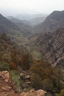
The wildlife of Djibouti, consisting of its flora and fauna, is in a harsh landscape with forest accounting for less than one percent of its area. Most species are found in the northern part of the country in the Day Forest National Park at an average elevation of 1,500 metres (4,900 ft), including the massif Goda, with a peak of 1,783 metres (5,850 ft). It covers an area of 3.5 square kilometres (1.4 sq mi) of Juniperus procera forest, with many of the trees rising to 20 metres (66 ft) height. This forest area is the main habitat of the critically endangered and endemic Djibouti spurfowl, and another recently noted vertebrate, Platyceps afarensis. The area also contains many species of woody and herbaceous plants, including boxwood and olive trees, which account for sixty percent of the identified species in the country.

<span class="mw-page-title-main">Holhol</span> Town in Ali Sabieh, Djibouti

Holhol is a town in the Ali Sabieh Region of Djibouti. It is located 44 kilometres south-west of the capital Djibouti City, at an altitude of 450m. Holhol enjoys a semi-arid climate. The surrounding district is rich in both livestock and fledgling agriculture. It is notable for being the birthplace of Cheik Osman Waiss a nationalist and anti-colonial where he began his movement.

<span class="mw-page-title-main">Tourism in Djibouti</span>

Tourism in Djibouti is one of the growing economic sectors of the country and is an industry that generates 53,000 and 73,000 arrivals per year, with its favorable beaches and climate and also including islands and beaches in the Gulf of Tadjoura and the Bab al-Mandab. The main tourist activities are scuba diving, fishing, trekking and hiking, discovering the nomadic way, bird watching, and sun, sea and sand.

<span class="mw-page-title-main">Subdivisions of Djibouti</span> Structure description

Djibouti is sectioned into 5 regions and one city. It is further subdivided into 20 districts.

<span class="mw-page-title-main">Ethiopian xeric grasslands and shrublands</span> Ecoregion in northeastern Africa

The Ethiopian xeric grasslands and shrublands ecoregion is a semi-desert strip on or near the Red Sea and the Gulf of Aden coasts in Eritrea, Ethiopia, Djibouti and Somaliland. This ecoregion lies mainly between sea level and 800 meters (m) elevation. There are, however, many hills and massifs, which range up to 1300 m as well as outstanding fault-induced depressions, such as the Danakil, lying as low as 155 m below sea level. This region is extremely active tectonically, experiencing many earthquakes and intermittently active volcanoes. Rainfall is very low and yearly averages range from 100 to 200 millimeters (mm), with less rain falling closer to the coast. There are many species of interest, including the endemic Archer's lark, a species of dragon tree, and a large suite of desert ungulates, including the last viable population of African wild ass.

<span class="mw-page-title-main">Ali Adde</span> Town in Ali Sabieh, Djibouti

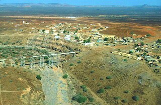
Ali Adde is a town in Djibouti. It is located some 69 kilometers south of the capital, Djibouti City, with an elevation of 530 meters above sea level. It is the site of a UNHCR base hosting 12,363 refugees camp as of 2015. It sprawls on a wide basin surrounded by granitic mountains on some sides. The center is run by the UNHCR, and its operations are financed by foreign donors.

<span class="mw-page-title-main">Arta Mountains</span>

The Arta Mountains, also known as the Great Mountains of Arta are a mountain range in Djibouti. They sit at an average elevation of 700 metres (2,300 ft) above sea level, is the tenth highest point in Djibouti. The mountains lie to the south of the Gulf of Tadjoura, in the Arta Region. They are situated approximately 35 kilometres (21 mi) west of the capital Djibouti City, and 69 kilometres (43 mi) by road from Ali Sabieh.

<span class="mw-page-title-main">Djiboutian Army</span> Land warfare branch of Djiboutis military

The Djiboutian National Army is the largest branch of the Djibouti Armed Forces and is based in the Djiboutian capital of Djibouti. Djibouti has upgraded its Ground Forces with advanced additions from domestic engineering and modifications. It must operate in mountainous and other rugged terrain, but it must do this without affecting the mechanized capability that is needed to confront regional forces.

The Dagouein Mountain is an average elevation of 1,124 metres (3,688 ft) above sea level, is the seventh highest point in Djibouti. The mountain forms one of the geographic resources of the area.

<span class="mw-page-title-main">Boura Mountains</span>

The Boura Mountains are a mountain range in Djibouti. With a mean peak height of 1,003 metres (3,291 ft) is the ninth highest point in Djibouti, the ecology of this landform is semi-desert. The mountain is located approximately 32 km (20 mi) east of Ali Sabieh, 13 kilometres from Assamo by road. The altitude and size of the range affects its weather, with precipitation levels varying greatly and climatic conditions consisting of distinct zones. Wildlife live in the higher peaks to elevations of 1,003 metres (3,291 ft). Issa Somali have a long history in the Boura Mountains.

References

  1. "Djibouti". The World Factbook. CIA. April 16, 2015. Retrieved April 15, 2015.
  2. 1 2 "Highest Mountains in Djibouti".
  3. "Eritrean coastal desert". Terrestrial Ecoregions. World Wildlife Fund.
  4. Awaleh, Mohamed Osman; Boschetti, Tiziano; Soubaneh, Youssouf Djibril; Kim, Yongje; Baudron, Paul; Kawalieh, Ali Dirir; Ahmed, Moussa Mahdi; Daoud, Mohamed Ahmed; Dabar, Omar Assowe; Kadieh, Ibrahim Houssein; Adiyaman, Özlem; Elmi, Sikie Abdillahi; Chirdon, Mahamoud Ali (2018). "Geochemical, multi-isotopic studies and geothermal potential evaluation of the complex Djibouti volcanic aquifer (Republic of Djibouti)". Applied Geochemistry. 97: 301–321. Bibcode:2018ApGC...97..301A. doi:10.1016/j.apgeochem.2018.07.019. S2CID   134565958.