Geological history of the Precordillera terrane

Last updated

The Precordillera terrane of western Argentina is a large mountain range located southeast of the main Andes mountain range. The evolution of the Precordillera is noted for its unique formation history compared to the region nearby. The Cambrian-Ordovian sedimentology in the Precordillera terrane has its source neither from old Andes nor nearby country rock, but shares similar characteristics with the Grenville orogeny of eastern North America. This indicates a rift-drift history of the Precordillera in the early Paleozoic. The Precordillera is a moving micro-continent which started from the southeast part of the ancient continent Laurentia (current location: North American plate). The separation of the Precordillera (also named Cuyania [1] ) started around the early Cambrian. The mass collided with Gondwana (the ancient supercontinent in the southern hemisphere) around Late Ordovician period. Different models and thinking of rift-drift process and the time of occurrence have been proposed. [2] [3] [4] This page focuses on the evidence of drifting found in the stratigraphical record of the Precordillera, as well as exhibiting models of how the Precordillera drifted to Gondwana.

Contents

Simplified map showing location of present Precordillera and surrounding geological complex LocationofPrecordillera01.png
Simplified map showing location of present Precordillera and surrounding geological complex

Location

Precordillera is a Spanish geographical term for hills and mountains lying before a greater range. The term is derived from cordillera (mountain range)—literally "pre-mountain range"—and applied usually to the Andes. [5]

The Precordillera is in western Argentina and can be traced by the thrust-fold belt. [6] It is about 200 km wide, and stretches 800 km from latitude 29°S to 33°S in western Argentina, with its south end in Mendoza, through San Juan, to La Rioja in the north. The northern and southern boundaries are not precisely defined. [7]

In terms of geological regions, the northeastern boundary connects to the western Pampeanas and the Famatina ranges, and the eastern margin connects to the frontal Cordillera then the Chilenia Terrace. [7]

Evidence of rifting

Stratigraphic records

The Early-Cambrian to Ordovician deposits of Precordillera are composed of 3000 m thickness of marine carbonate sections with multiple phases of grain size variation. The Precambrian Precordillera basement is Grenvillian-type and the Cambrian-Ordovician layer is uniquely found in Precordillera compared with surrounding Andes and Sub-Andes belt. [8]

The sedimentary deposit in Precordillera is recognized as "typifying low-latitude stable passive-margin continental terrace deposits". [8] That means Precordillera was transformed from thermal continental margin subsiding to passive margin. The facies types of Cambrian-Ordovician carbonate deposit in Precordillera matches the Southern Appalachian platform, suggesting the origin of Precordillera from Laurentia. [8]

The Precordillera formation ranging from Early Cambrian to Late Ordovician would be introduced as follows: [7] [9]

Cerro Totora Formation (Early Cambrian)

The Cerro Totora Formation with a thickness of 340 m contains red marine sandstone and siltstone at the lower section. At upper section, the red evaporites are interbedded with carbonate sandstone and siltstone. At the top of the formation, quartz arenites present indicate the upper boundary of the Cerro Totora Formation. [9] The evaporites and red sedimentary rock indicate the transition from syn-rift development to the ending of rifting. The upper formation comprises Early Cambrian olenellid trilobites which indicates the region was a normal marine environment. [9]

La Laja Formation (Early to Mid Cambrian)

The 525 m thick La Laja formation is a thick layer of progradational carbonate complex. The base is composed of a fine grained lime mudstone which contains fossils of olenellid trilobites and phosphatic brachiopods. [9] Higher in the layer, the carbonate contain larger grains, so that the carbonates are described as oolitic limestone or grainstone. Overall the sediment shows a couple of depositional conditions – from fine grain mudstone forming in an open marine environment to increasing grain size of grainstone, oolitic limestone in a shallow marine environment. [9]

Zonda and La Flecha Formation (Middle to Late Cambrian)

The Zonda (200-300 m thick) and La Flecha Formation (400-700 m thick) starts from the continuous layers of La Laja Formation limestone to peritidal dolomite. [9] They show a total of three sequences of shallowing-upward features, one shoaling upward sequence in the Zonda formation and two in the La Flecha Formation. It is described as aggradational carbonate complex because of insignificant lateral sift of deposits. From this point the terrace was undergoing the drifting process, traveling from Laurentia to Gondwana. Also abundant distributions of thrombolites dominate each basal sequence and become less significant in the uppermost intervals. [9]

La Silla Formation (Early Ordovician)

The La Silla Formation (400 m thick) is the start of Ordovician deposits. It shows depositions of subtidal carbonate mudstone and wackestone which is sandwiched by peritidal carbonates. The formation lacks erosion features as well as terrestrial deposits, indicating an open-marine environment. Models deduced that the Precordillera terrace had been travelling through the Iapetus Ocean approaching the Gondwana supercontinent. [9]

San Juan Formation (Mid Ordovician)

The San Juan Formation (330 m thick) continues as a carbonate deposit of packstone, grainstone, wackestone, and mudstone. It shows two transgressive system tracks indicating drowning events, or in other words the eustatic rise of sea level. The significant reef accumulations can be found in two intervals – the packstone at the boundary above La Silla Formation, and during the sudden change from marine environment to shallow-water grainstone. [9] As sea level rises, fine and dark mudstone and shale deposit as an indication of approaching the subduction zone beneath Gondwana. [9]

Late Ordovician unconformity

The sedimentary records no longer continuous on top of the San Juan Formation, and it is marked as an erosional unconformity. On top of the black shale the eastern Precordillera crust received a continental rise, inducing the rapid intensive events shown by the rifting structure on the deposits above the unconformity. The western basin consists of black graptolitic shale with non-constant thickness which contains silicate clasts, believed to be a kind of rifting-related deposit. [9] The unconformity symbolizes the increasing tectonic activity, probably the start of rifting events and the collision between Precordillera and Gondwana.

Evolutionary diagram of Precordillera from Early Cambrian to Mid-Ordovician showing A) Separation of Precordillera from Laurentia B) Passive margin at the same time Famatinian arc existed C) Collision of Precordillera towards Gondwana-Famatina mass Evolutionary Diagram.png
Evolutionary diagram of Precordillera from Early Cambrian to Mid-Ordovician showing A) Separation of Precordillera from Laurentia B) Passive margin at the same time Famatinian arc existed C) Collision of Precordillera towards Gondwana-Famatina mass
Summary of Cambrian-Ordovician stratigraphy (top to bottom) [9]
FormationAgeThicknessDescription
Erosional unconformity – extensional rifting
San Juan Formation Middle Ordovician 330 metres (1,080 ft)Two trangressive sequences of carbonates. Reef accumulations in shallow deposits
La Silla Formation Early Ordovician 400 metres (1,300 ft)Subtidal carbonate sandwiched by peritidal carbonates. Without detrital deposition.
Zonda and La Flecha Formations Late Cambrian 600–1,000 metres (2,000–3,300 ft)Aggradational peritidal dolomites
La Laja Formation Early to Middle Cambrian 525 metres (1,722 ft)Progradational carbonate complex with olenllid trilobites
Cerro Totora Formation Early Cambrian 340 metres (1,120 ft)Red sandstone and evaporites

Trilobites

The olenellid trilobites found in early Cambrian sequences are identical to those in the fragments in Laurentia. The similar fossil records have contributed greatly to the hypothesis that Precordillera was linked to Laurentia until Cambrian separation. [10] Precordillera fauna records diverge from that in Laurentia after the Ordovician, and receive an increasing amount of fauna that also appears in Gondwana. This gets to the point that Precordillera is separated from Laurentia by sea-floor expansion, becoming independent continents and approaching Gondwana. [7]

Models of evolution

Regarding stratigraphical records and fossil evidence, multiple geological models has been published to explain the evolution of the Precordillera contributing to the Pre-Andean history of Gondwana.

Micro-continent model

The micro-continent model was suggested by Thomas and Astini. [11] It says that Precordillera originates from Laurentia from the south-east of the Ouachita Embayment. It detached via the Ouachita Rift in Early Cambrian. After that Precordillera acts as an independent continent traveling through the Iapetus Ocean along the Alabama-Oklahoma transform fault. Finally the continent collided with the Gondwana continent in middle Ordovician, changing the environment from a passive margin to extensive rifting. This model is strongly supported by the thick carbonate complex as well as matching fauna records. [2]

Plan-map view of microcontinent model. Drawn from Thomas & Astini (1996) NB. Inset E and F should read as follows: (E) Middle Ordovician (F) Late Ordovician Microcontinent model.png
Plan-map view of microcontinent model. Drawn from Thomas & Astini (1996) NB. Inset E and F should read as follows: (E) Middle Ordovician (F) Late Ordovician

Continental-collision model

Continental-Collision Model sketched from idea of Benedetto (1998) Continental-Collision model.png
Continental-Collision Model sketched from idea of Benedetto (1998)

The continent-collision model is an alternative model explaining the evolution of Precordillera. [2] Dalziel has reconstructed the Paleozoic plate development and proposed a narrow early Paleozoic Iapetus Ocean between Laurentia and Gondwana. [3] Dalziel named the model as the "Texas Plateau Hypothesis". Texas Plateau is the term describing the Precordillera at the time it was attached to its parental Laurentia, suggesting that Precordillera was always attached to Laurentia until a supercontinental collision between Laurentia and Gondwana shut down the Iapetus Ocean. After the collision, the continent rifted away during late Ordovician, so that Precordillera was no longer attached to Laurentia and stuck to the western Gondwana. This model is also known as "paired rift margin". [8]

Precordillera as not a part of Laurentia

Finney reconsidered the possibility of micro-continent model through U-Pb zircon dating and discovered that the dating result favours the Gondwana province instead of a drifting model from Laurentia. [4] He raised multiple ideas, such as reconsidering Western Sierras Pampeanas as autochthonous to Gondwana; the rocks between Precordillera and Famatina are instead a crustal fragment of Gondwana [4] that cannot be explained by the Laurentian drifting models. He proposed another model saying the Precordillera, or Cuyania was at the Southern margin of Gondwana and started drifting along the transform fault in mid-late Ordovician. Finally it reached the position where it was subducting beneath the Famatinan belt in Devonian. [7]

Post-collision period

After the collision of Precordillera with Gondwana, Precordillera is dominated by crustal extension. Multiple sets of horsts and grabens created sudden drowning and shallowing events. Elevated blocks were then eroded and the irregular fragments were collected and deposited at the wedges or grabens, forming conglomerate or breccia in the graben area. [7] The fauna records in Precordillera become consistent with Gondwana. [2] During Silurian to Devonian periods, increasing metamorphism or magmatic activities with structural deformation showed the approach of the Chilenia terrace from the west and Precordillera finally locked into the position with Gondwana. [2]

Related Research Articles

Laurasia Northern supercontinent that formed part of the Pangaea supercontinent

Laurasia, a portmanteau for Laurentia and Asia, was the more northern of two minor supercontinents that formed part of the Pangaea supercontinent from c.425 million years ago (Mya) to 200 Mya. It separated from Gondwana 215 to 175 Mya during the breakup of Pangaea, drifting farther north after the split and finally broke apart with the opening of the North Atlantic Ocean c. 56 Mya.

Iapetus Ocean ocean that existed in the late Neoproterozoic and early Paleozoic eras

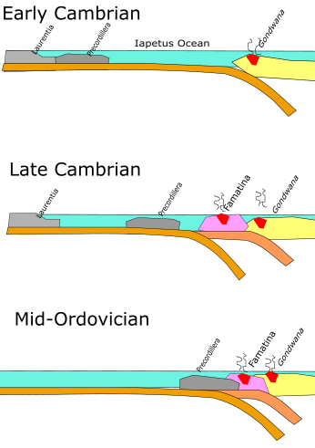
The Iapetus Ocean was an ocean that existed in the late Neoproterozoic and early Paleozoic eras of the geologic timescale. The Iapetus Ocean was situated in the southern hemisphere, between the paleocontinents of Laurentia, Baltica and Avalonia. The ocean disappeared with the Acadian, Caledonian and Taconic orogenies, when these three continents joined to form one big landmass called Euramerica. The "southern" Iapetus Ocean has been proposed to have closed with the Famatinian and Taconic orogenies, meaning a collision between Western Gondwana and Laurentia.

Baltica Late-Proterozoic to early-Palaeozoic continent

Baltica is a paleocontinent that formed in the Paleoproterozoic and now constitutes northwestern Eurasia, or Europe north of the Trans-European Suture Zone and west of the Ural Mountains. The thick core of Baltica, the East European Craton, is more than three billion years old and formed part of the Rodinia supercontinent at c.Ga.

Avalonia microcontinent in the Paleozoic era

Avalonia was a microcontinent in the Paleozoic era. Crustal fragments of this former microcontinent underlie south-west Great Britain, southern Ireland, and the eastern coast of North America. It is the source of many of the older rocks of Western Europe, Atlantic Canada, and parts of the coastal United States. Avalonia is named for the Avalon Peninsula in Newfoundland.

Acadian orogeny North American orogeny

The Acadian orogeny is a long-lasting mountain building event which began in the Middle Devonian, reaching a climax in the early Late Devonian. It was active for approximately 50 million years, beginning roughly around 375 million years ago, with deformational, plutonic, and metamorphic events extending into the Early Mississippian. The Acadian orogeny is the third of the four orogenies that created the Appalachian orogen and subsequent basin. The preceding orogenies consisted of the Potomac and Taconic orogeny, which followed a rift/drift stage in the Late Neoproterozoic. The Acadian orogeny involved the collision of a series of Avalonian continental fragments with the Laurasian continent. Geographically, the Acadian orogeny extended from the Canadian Maritime provinces migrating in a southwesterly direction toward Alabama. However, the Northern Appalachian region, from New England northeastward into Gaspé region of Canada, was the most greatly affected region by the collision.

Taconic orogeny A mountain building period that affected most of New England

The Taconic orogeny was a mountain building period that ended 440 million years ago and affected most of modern-day New England. A great mountain chain formed from eastern Canada down through what is now the Piedmont of the East coast of the United States. As the mountain chain eroded in the Silurian and Devonian periods, sediments from the mountain chain spread throughout the present-day Appalachians and midcontinental North America.

Caledonian orogeny

The Caledonian orogeny was a mountain-building era recorded in the northern parts of Ireland and Britain, the Scandinavian Mountains, Svalbard, eastern Greenland and parts of north-central Europe. The Caledonian orogeny encompasses events that occurred from the Ordovician to Early Devonian, roughly 490–390 million years ago (Ma). It was caused by the closure of the Iapetus Ocean when the continents and terranes of Laurentia, Baltica and Avalonia collided.

The Rheic Ocean was an ocean which separated two major palaeocontinents, Gondwana and Laurussia (Laurentia-Baltica-Avalonia). One of the principal oceans of the Palaeozoic, its sutures today stretch 10,000 km (6,200 mi) from Mexico to Turkey and its closure resulted in the assembly of the supercontinent Pangaea and the formation of the Variscan–Alleghenian–Ouachita orogenies.

Geological history of Earth The sequence of major geological events in Earths past

The geological history of Earth follows the major events in Earth's past based on the geological time scale, a system of chronological measurement based on the study of the planet's rock layers (stratigraphy). Earth formed about 4.54 billion years ago by accretion from the solar nebula, a disk-shaped mass of dust and gas left over from the formation of the Sun, which also created the rest of the Solar System.

Geology of Norway

The geology of Norway encompasses the history of earth that can be interpreted by rock types found in Norway, and the associated sedimentological history of soils and rock types.

Gondwana Neoproterozoic to Carboniferous supercontinent

Gondwana or Gondwanaland was a supercontinent that existed from the Neoproterozoic until the Jurassic. Gondwana was not considered a supercontinent by the earliest definition, since the landmasses of Baltica, Laurentia, and Siberia were separate from it.

Laurentia A large continental craton that forms the ancient geological core of the North American continent

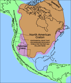
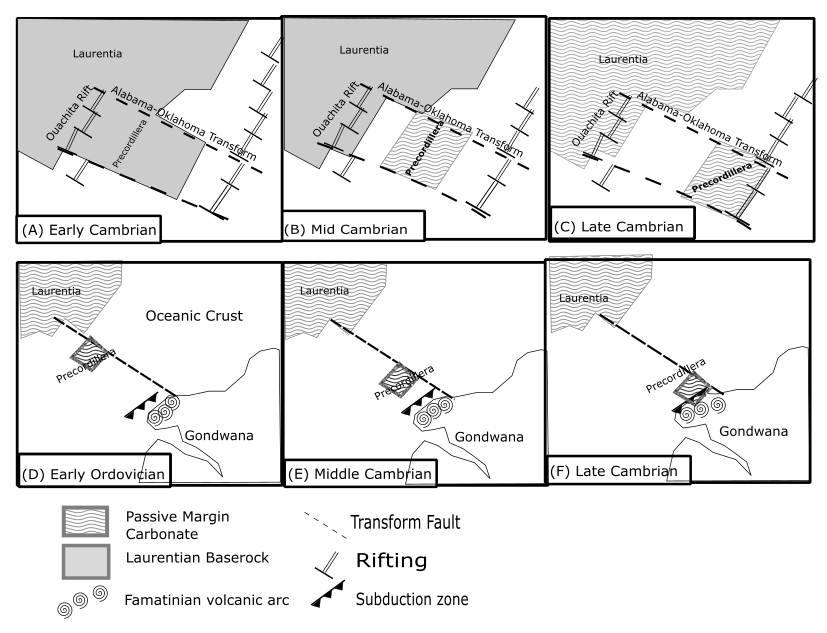
Laurentia or the North American Craton is a large continental craton that forms the ancient geological core of North America. Many times in its past, Laurentia has been a separate continent, as it is now in the form of North America, although originally it also included the cratonic areas of Greenland and also the northwestern part of Scotland, known as the Hebridean Terrane. During other times in its past, Laurentia has been part of larger continents and supercontinents and itself consists of many smaller terranes assembled on a network of Early Proterozoic orogenic belts. Small microcontinents and oceanic islands collided with and sutured onto the ever-growing Laurentia, and together formed the stable Precambrian craton seen today.

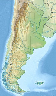
The Precordillera Terrane or Cuyania was an ancient microcontinent or terrane whose history affected many of the older rocks of Cuyo in Argentina. It was separated by oceanic crust from the Chilenia terrane which accreted into it at ~420-390 Ma when Cuyania was already amalgamated with Gondwana. The hypothesized Mejillonia Terrane in the coast of northern Chile is considered by some geologists to be a single block with Cuyania.

The Carolina Terrane, also called the Carolina Superterrane or Carolinia, is an exotic terrane running ~370 miles (600 km) approximately North-South from central Georgia to central Virginia in the United States. It constitutes a major part of the eastern Piedmont Province.

Geology of Massachusetts

The geology of Massachusetts includes numerous units of volcanic, intrusive igneous, metamorphic and sedimentary rocks formed within the last 1.2 billion years. The oldest formations are gneiss rocks in the Berkshires, which were metamorphosed from older rocks during the Proterozoic Grenville orogeny as the proto-North American continent Laurentia collided against proto-South America. Throughout the Paleozoic, overlapping the rapid diversification of multi-cellular life, a series of six island arcs collided with the Laurentian continental margin. Also termed continental terranes, these sections of continental rock typically formed offshore or onshore of the proto-African continent Gondwana and in many cases had experienced volcanic events and faulting before joining the Laurentian continent. These sequential collisions metamorphosed new rocks from sediments, created uplands and faults and resulted in widespread volcanic activity. Simultaneously, the collisions raised the Appalachian Mountains to the height of the current day Himalayas.

Famatinian orogeny

The Famatinian orogeny is an orogeny that predates the rise of the Andes and that took place in what is now western South America during the Paleozoic, leading to the formation of the Famatinian orogen also known as the Famatinian belt. The Famatinian orogeny lasted from the Late Cambrian to at least the Late Devonian and possibly the Early Carboniferous, with orogenic activity peaking about 490 to 460 million years ago. The orogeny involved metamorphism and deformation in the crust and the eruption and intrusion of magma along a Famatinian magmatic arc that formed a chain of volcanoes. The igneous rocks of the Famatinian magmatic arc are of calc-alkaline character and include gabbros, tonalites and granodiorites. The youngest igneous rocks of the arc are granites.

Puncoviscana Formation

Puncoviscana Formation is a formation of sedimentary and metasedimentary rocks Late Ediacaran and Lower Cambrian age, estimated at between 700 and 535 Ma, that crop out in the Argentine Northwest. Most of the formation lies in Jujuy, Salta and Tucumán Province albeit some authors extend the formation further south to the Sierras Pampeanas near Córdoba.

Tectonic evolution of Patagonia

Patagonia comprises the southernmost region of South America, portions of which lie either side of the Chile–Argentina border. It has traditionally been described as the region south of the Rio Colorado, although the physiographic border has more recently been moved southward to the Huincul fault. The region's geologic border to the north is composed of the Rio de la Plata craton and several accreted terranes comprising the La Pampa province. The underlying basement rocks of the Patagonian region can be subdivided into two large massifs: the North Patagonian Massif and the Deseado Massif. These massifs are surrounded by sedimentary basins formed in the Mesozoic that underwent subsequent deformation during the Andean orogeny. Patagonia is known for their vast earthquakes and the damage.

The geology of Argentina includes ancient Precambrian basement rock affected by the Grenville orogeny, sediment filled basins from the Mesozoic and Cenozoic as well as newly uplifted areas in the Andes.

The geology of Yukon includes sections of ancient Precambrian Proterozoic rock from the western edge of the proto-North American continent Laurentia, with several different island arc terranes added through the Paleozoic, Mesozoic and Cenozoic, driving volcanism, pluton formation and sedimentation.

References

  1. Ramos, V.A., Jordan, T.E., Allmendinger, R.W., Mpodozis, M.C., Kay, S.M., Cortes, J.M., Palma, M. (1986). Paleozoic terranes of the central Argentine-Chilean Andes. Tectonics, 5. pp. 5, 855–880.CS1 maint: multiple names: authors list (link) CS1 maint: location (link)
  2. 1 2 3 4 5 Benedetto, J. L. (1998). Early Palaeozoic Brachiopods and associated shelly faunas from western Gondwana: their bearing on the geodynamic history of the pre-Andean margin. The Proto-Andean Margin of Gondwana. Geological Society, London, Special Publications. London. pp. 57–83.
  3. 1 2 Dalziel, I. W. D. (1993). Tectonic tracers and the origin of the proto-Andean margin. XII Congreso Geologico Argentino u II Congreso de Exploracion deHidrocarburos, Mendoza, Actas, III. pp. 367–374.
  4. 1 2 3 Finney, S. C. (2007). "The parautochthonous Gonwanan origin of the Cuyania (greater Precordillera) terrane of Argentina: A re-evaluation of evidence used to support an allochthonous Laurentian origin". Geologica Acta. 5: 127–158.
  5. "precordillera". Diccionario de la lengua española - Edición del Tricentenario (in Spanish).
  6. Jordan, T. E. (1983). "Andean segmentation related to geometry of subducted Nazca plate". Geological Society of America Bulletin. 94: 341–361. doi:10.1130/0016-7606(1983)94<341:atrtgo>2.0.co;2.
  7. 1 2 3 4 5 6 Astini, R. A. (1998). Stratigraphical evidence supporting the rifting, drifting and collision of the Laurentian Precordillera terrane of western Argentina. The Proto-Andean Margin of Gondwana. Geological Society. London, Special Publication. pp. 11–33.
  8. 1 2 3 4 Bond, C. G., Nickson, A. & Kominz, M. A. (1984). Breakup of a supercontinent between 625 Ma and 555 Ma: new evidence and implications for continental histories. Earth Planet Science Letters, 80. pp. 29–42.CS1 maint: multiple names: authors list (link)
  9. 1 2 3 4 5 6 7 8 9 10 11 12 Keller, M., Buggisch, W. & Lehnert, O. (1998). The stratigraphical record of the Argentine Precordillera and its plate-tectonic background. The Proto-Andean Margin of Gondwana. Geological Society, London, Special Publication, 142. pp. 35–56.CS1 maint: multiple names: authors list (link)
  10. Astini, R.A. (1995). "Paleoclimates and paleogeographic paths of the Argentine Precordillera during the Ordovician: evidence from climatically sensitive lithofacies". Ordovician Odyssey. Book 77: 177–180.
  11. Thomas, W. A.; Astini, R. A. (1996). The Argentine Precordllera: a traveler from the Ouachita embayment of North American Laurentia. Science, 273. pp. 752–757.