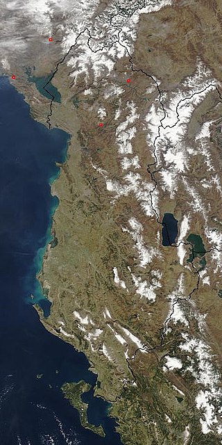
Albania, officially the Republic of Albania, is a country in Southeast Europe. It is in the Balkans, on the Adriatic and Ionian Seas within the Mediterranean Sea, and shares land borders with Montenegro to the northwest, Kosovo to the northeast, North Macedonia to the east and Greece to the south. Spanning an area of 28,748 km2 (11,100 sq mi), it has a varied range of climatic, geological, hydrological and morphological conditions. Albania's landscapes range from rugged snow-capped mountains in the Albanian Alps and the Korab, Skanderbeg, Pindus and Ceraunian Mountains, to fertile lowland plains extending from the Adriatic and Ionian seacoasts. Tirana is the capital and largest city in the country, followed by Durrës, Vlorë, and Shkodër.

Albania is a country in Southeastern Europe that lies along the Adriatic and Ionian Seas, with a coastline spanning approximately 476 km (296 mi). Situated on the Balkan Peninsula, it is one of the most mountainous countries in Europe. It is bounded by Montenegro to the northwest, Kosovo to the northeast, North Macedonia to the east and Greece to the southeast and south.

The Colorado Mineral Belt (CMB) is an area of ore deposits from the La Plata Mountains in Southwestern Colorado to near the middle of the state at Boulder, Colorado, and from which over 25 million troy ounces of gold were extracted beginning in 1858. The belt is a "northeast-striking zone defined by: a Proterozoic shear zone system ; a suite of Laramide-aged plutons and related ore deposits ; a major gravity low ; low-crustal velocities; and high heat flow ." Mining districts include:

The Carpathian Mountains or Carpathians are a range of mountains forming an arc across Central Europe. Roughly 1,500 km (930 mi) long, it is the third-longest European mountain range after the Urals at 2,500 km (1,600 mi) and the Scandinavian Mountains at 1,700 km (1,100 mi). The range stretches from the far eastern Czech Republic (3%) and Austria (1%) in the northwest through Slovakia (21%), Poland (10%), Ukraine (10%), Romania (50%) to Serbia (5%) in the south. The highest range within the Carpathians is known as the Tatra mountains in Poland and Slovakia, where the highest peaks exceed 2,600 m (8,500 ft). The second-highest range is the Southern Carpathians in Romania, where the highest peaks range between 2,500 m (8,200 ft) and 2,550 m (8,370 ft).

Dibër County is one of the 12 counties of the Republic of Albania, spanning a surface area of 2,586 square kilometres (998 sq mi) with the capital in Peshkopi. The county borders on the counties of Durrës, Elbasan, Kukës, Lezhë, Tirana and the country of North Macedonia. It is divided into the four municipalities of Bulqizë, Dibër, Klos and Mat. The municipalities are further subdivided into 290 towns and villages in total.

Kukës County is a landlocked county in northeastern Albania, with the capital in Kukës. The county spans 2,374 square kilometres (917 sq mi) and had a total population of 74,388 people as of 2021. The county borders on the counties of Dibër, Lezhë and Shkodër and the countries of Montenegro, Serbia and North Macedonia. It is divided into three municipalities: Has, Kukës and Tropojë. The municipalities are further subdivided into 290 towns and villages in total.

The Alpine orogeny or Alpide orogeny is an orogenic phase in the Late Mesozoic (Eoalpine) and the current Cenozoic that has formed the mountain ranges of the Alpide belt.

The Moine Thrust Belt or Moine Thrust Zone is a linear tectonic feature in the Scottish Highlands which runs from Loch Eriboll on the north coast 190 kilometres (120 mi) south-west to the Sleat peninsula on the Isle of Skye. The thrust belt consists of a series of thrust faults that branch off the Moine Thrust itself. Topographically, the belt marks a change from rugged, terraced mountains with steep sides sculptured from weathered igneous, sedimentary and metamorphic rocks in the west to an extensive landscape of rolling hills over a metamorphic rock base to the east. Mountains within the belt display complexly folded and faulted layers and the width of the main part of the zone varies up to 10 kilometres (6.2 mi), although it is significantly wider on Skye.
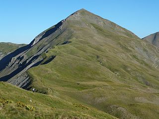
Gramos is a mountain chain situated on the border of Albania and Greece. Part of the larger northern Pindus mountain range, its highest peak, Maja e Çukapeçit, rises at an elevation of 2,523 m (8,278 ft).

Kosovo is a small and landlocked country in Southeastern Europe. The country is strategically positioned in the center of the Balkan Peninsula enclosed by Montenegro to the west, Serbia to the north and east, North Macedonia to the southeast, and Albania to the southwest. It has no direct access to the Mediterranean Sea but its rivers flow into three seas, the Adriatic, Aegean and Black Sea.

Shebenik National Park is a national park in eastern Albania adjacent to the border with North Macedonia. It encompasses 34,507.9 hectares (345.079 km2) and is specifically marked by a mountainous landscape supplied with glacial lakes, valleys, dense coniferous and deciduous forests and alpine meadows and pastures. Elevations in the park vary from 300 metres to over 2,200 metres above the Adriatic at the peak of Shebenik and Jabllanica, hence the name. It dwells a number of endangered species that are fast becoming rare in Southern Europe, including the brown bear, gray wolf and balkan lynx. The abundance in wildlife can in part be explained by the variety of vegetation types and remote location.

The Gadishulli Peninsula, also known as Cape Linguetta, is a peninsula of the Mediterranean Sea located in Southern and Southeastern Europe, which is almost completely surrounded by both the Adriatic Sea to the north and the Ionian Sea to the south. It is located in Southwestern Albania along the Albanian Ionian Sea Coast, whereas the Strait of Otranto separates it from Italy. The Strait of Mezokanal separates the peninsula from Sazan Island, while in the southeast stretches the Bay of Vlorë. In classical antiquity, its name was the "Akrokeraunian Peninsula", whose name was derived from the eponymous Akrokeraunian mountains;this is because, in terms of geology, the Rrëza e Kanalit on the peninsula represent the continuation of said mountains, which are the highest and most extensive mountain range system that extends parallel to the Ionian Sea. Karaburun peninsula is sometimes called Ceraunian Peninsula due to the name of the mountain range. Created during the mesozoic era of the cretaceous and paleogene period, the crests of the mountain range form a northwest-southeast line with a series of distinct peaks along its irregular structure that are broken apart by steep and unequally slopes. The highest peaks are namely, the Maja Çaderës, Maja e Flamurit, Maja e Koretës and Maja e Ilqes.
The Central Mountain Region is a physiogeographical region encompassing the central and eastern edge of Albania. It comprises the mountainous inland extending all the way from the valley of Drin and the mountains of Sharr, Skanderbeg, Korab, and Shebenik-Jabllanicë, through the lakes of Ohrid and Prespa, until it reaches the village of Ersekë and the mountains of Pindus close to the border between the country and Greece.

Maja e Thatë is a 2,406-metre-high (7,894 ft) mountain peak of the Albanian Alps in Albania. It is located within Valbonë Valley National Park, roughly 2 km (1 mi) northwest of Valbonë and rises more than 1,500 m (4,921 ft) above the village. The mountain's southern and western lower slopes are relatively rich in beech and pine forests, while the higher slopes consist of very steep dolomite and limestone rock walls, suitable for mountaineering and rock climbing.
The Paranapanema block is a coherent block of lithosphere located in southeastern South America spanning roughly the same area as the Paraná Basin. The existence of a tectonically stable zone beneath the Paraná Basin was first suggested in 1975. Despite difficulties in accessing the buried Paranapanema block it is inferred it must be composed mostly of orthogneiss and that it existed before the Brasiliano orogeny.

For a small country, Albania is characterised by a considerable wealth of terrestrial and marine ecosystems and habitats with contrasting floral, faunal, and fungal species, defined in an area of 28,748 square kilometres. Most of the country is predominantly of Mediterranean character, comprehending the country's center and south, while the alpine affinity is more visible in the northeast.

Prespa National Park is a national park situated in southeastern Albania on the border triangle shared with Greece and North Macedonia. At approximately 277.5 km2 (107.1 sq mi), the park encompasses the country's sections of the Great and Small Prespa Lake. It is considerably characterised by high mountains, narrow islands, vast freshwater wetlands, salt marshes, meadows, reed beds and dense forests.
The Albanian Ionian Sea Coast is a coastline of the north-eastern Ionian Sea, that encompasses the south-western border of the Republic of Albania, stretching from the southern half of Karaburun Peninsula, across the historical region of Labëria, the city of Sarandë, the mountains of the Ceraunians, and the Albanian Riviera, to the Lake of Butrint, where the Strait of Corfu separates the country from Greece.

The Buna River-Velipojë Protected Landscape is a protected landscape area in northwestern Albania, encompassing the estuary of Drin, the lagoon of Viluni, the river of Buna with its estuary, and the gulf of Drin that runs across the city of Velipojë alongside the Adriatic Sea.

