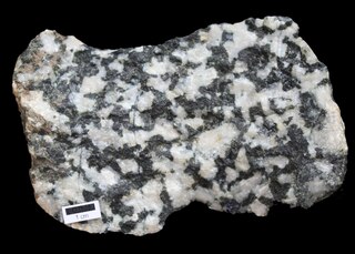
Diorite is an intrusive igneous rock formed by the slow cooling underground of magma that has a moderate content of silica and a relatively low content of alkali metals. It is intermediate in composition between low-silica (mafic) gabbro and high-silica (felsic) granite.

The Gascoyne Complex is a terrane of Proterozoic granite and metamorphic rock in the central-western part of Western Australia. The complex outcrops at the exposed western end of the Capricorn Orogen, a 1,000 km-long arcuate belt of folded, faulted and metamorphosed rocks between two Archean cratons; the Pilbara craton to the north and the Yilgarn craton to the south. The Gascoyne Complex is thought to record the collision of these two different Archean continental fragments during the Capricorn Orogeny at 1830–1780 Ma.
The Cadomian Orogeny was a tectonic event or series of events in the late Neoproterozoic, about 650–550 Ma, which probably included the formation of mountains. This occurred on the margin of the Gondwana continent, involving one or more collisions of island arcs and accretion of other material at a subduction zone. The precise events, and geographical position, are uncertain, but are thought to involve the terranes of Avalonia, Armorica and Iberia. Rocks deformed in the orogeny are found in several areas of Europe, including northern France, the English Midlands, southern Germany, Bohemia, southern Poland and the southwest Iberian Peninsula. The name comes from Cadomus, the Latin name for Caen, northern France. L Bertrand gave the orogeny its name in 1921, naming it after Cadomus the Gaulish name for Caen in Normandy. He defined the end as being marked by Lower Palaeozoic red beds.
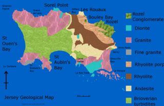
The geology of Jersey is characterised by the Late Proterozoic Brioverian volcanics, the Cadomian Orogeny, and only small signs of later deposits from the Cambrian and Quaternary periods. The kind of rocks go from conglomerate to shale, volcanic, intrusive and plutonic igneous rocks of many compositions, and metamorphic rocks as well, thus including most major types.

The geology of Alderney includes similarities in its rock to the neighbouring Normandy and Guernsey. Although Alderney is only five kilometers long, it has a geological history spanning half of the life of the earth. It is part of the Armorican Massif.

The Algoman orogeny, known as the Kenoran orogeny in Canada, was an episode of mountain-building (orogeny) during the Late Archean Eon that involved repeated episodes of continental collisions, compressions and subductions. The Superior province and the Minnesota River Valley terrane collided about 2,700 to 2,500 million years ago. The collision folded the Earth's crust and produced enough heat and pressure to metamorphose the rock. Blocks were added to the Superior province along a 1,200 km (750 mi) boundary that stretches from present-day eastern South Dakota into the Lake Huron area. The Algoman orogeny brought the Archean Eon to a close, about 2,500 million years ago; it lasted less than 100 million years and marks a major change in the development of the Earth's crust.
The Great Lakes tectonic zone (GLTZ) is bounded by South Dakota at its tip and heads northeast to south of Duluth, Minnesota, then heads east through northern Wisconsin, Marquette, Michigan, and then trends more northeasterly to skim the northernmost shores of lakes.

The geology of Massachusetts includes numerous units of volcanic, intrusive igneous, metamorphic and sedimentary rocks formed within the last 1.2 billion years. The oldest formations are gneiss rocks in the Berkshires, which were metamorphosed from older rocks during the Proterozoic Grenville orogeny as the proto-North American continent Laurentia collided against proto-South America. Throughout the Paleozoic, overlapping the rapid diversification of multi-cellular life, a series of six island arcs collided with the Laurentian continental margin. Also termed continental terranes, these sections of continental rock typically formed offshore or onshore of the proto-African continent Gondwana and in many cases had experienced volcanic events and faulting before joining the Laurentian continent. These sequential collisions metamorphosed new rocks from sediments, created uplands and faults and resulted in widespread volcanic activity. Simultaneously, the collisions raised the Appalachian Mountains to the height of the current day Himalayas.

The geology of the Isle of Skye in Scotland is highly varied and the island's landscape reflects changes in the underlying nature of the rocks. A wide range of rock types are exposed on the island, sedimentary, metamorphic and igneous, ranging in age from the Archaean through to the Quaternary.

The Vishnu Basement Rocks is the name recommended for all Early Proterozoic crystalline rocks exposed in the Grand Canyon region. They form the crystalline basement rocks that underlie the Bass Limestone of the Unkar Group of the Grand Canyon Supergroup and the Tapeats Sandstone of the Tonto Group. These basement rocks have also been called either the Vishnu Complex or Vishnu Metamorphic Complex. These Early Proterozoic crystalline rocks consist of metamorphic rocks that are collectively known as the Granite Gorge Metamorphic Suite; sections of the Vishnu Basement Rocks contain Early Paleoproterozoic granite, granitic pegmatite, aplite, and granodiorite that have intruded these metamorphic rocks, and also, intrusive Early Paleoproterozoic ultramafic rocks.

The geology of the Democratic Republic of the Congo is extremely old, on the order of several billion years for many rocks. The country spans the Congo Craton: a stable section of ancient continental crust, deformed and influenced by several different mountain building orogeny events, sedimentation, volcanism and the geologically recent effects of the East Africa Rift System in the east. The country's complicated tectonic past have yielded large deposits of gold, diamonds, coltan and other valuable minerals.
The geology of Cameroon is almost universally Precambrian metamorphic and igneous basement rock, formed in the Archean as part of the Congo Craton and the Central African Mobile Zone and covered in laterite, recent sediments and soils. Some parts of the country have sequences of sedimentary rocks from the Paleozoic, Mesozoic and Cenozoic as well as volcanic rock produced by the 1600 kilometer Cameroon Volcanic Line, which includes the still-active Mount Cameroon. The country is notable for gold, diamonds and some onshore and offshore oil and gas.

The geology of Ivory Coast is almost entirely extremely ancient metamorphic and igneous crystalline basement rock between 2.1 and more than 3.5 billion years old, comprising part of the stable continental crust of the West African Craton. Near the surface, these ancient rocks have weathered into sediments and soils 20 to 45 meters thick on average, which holds much of Ivory Coast's groundwater. More recent sedimentary rocks are found along the coast. The country has extensive mineral resources such as gold, diamonds, nickel and bauxite as well as offshore oil and gas.
The geology of Malawi formed on extremely ancient crystalline basement rock, which was metamorphosed and intruded by igneous rocks during several orogeny mountain building events in the past one billion years. The rocks of the Karoo Supergroup and newer sedimentary units deposited across much of Malawi in the last 251 million years, in connection with a large rift basin on the supercontinent Gondwana and the more recent rifting that has created the East African Rift, which holds Lake Malawi. The country has extensive mineral reserves, many of them poorly understand or not exploited, including coal, vermiculite, rare earth elements and bauxite.

The geology of Sierra Leone is primarily very ancient Precambrian Archean and Proterozoic crystalline igneous and metamorphic basement rock, in many cases more than 2.5 billion years old. Throughout Earth history, Sierra Leone was impacted by major tectonic and climatic events, such as the Leonean, Liberian and Pan-African orogeny mountain building events, the Neoproterozoic Snowball Earth and millions of years of weathering, which has produced thick layers of regolith across much of the country's surface.
The geology of Nigeria formed beginning in the Archean and Proterozoic eons of the Precambrian. The country forms the Nigerian Province and more than half of its surface is igneous and metamorphic crystalline basement rock from the Precambrian. Between 2.9 billion and 500 million years ago, Nigeria was affected by three major orogeny mountain-building events and related igneous intrusions. Following the Pan-African orogeny, in the Cambrian at the time that multi-cellular life proliferated, Nigeria began to experience regional sedimentation and witnessed new igneous intrusions. By the Cretaceous period of the late Mesozoic, massive sedimentation was underway in different basins, due to a large marine transgression. By the Eocene, in the Cenozoic, the region returned to terrestrial conditions.
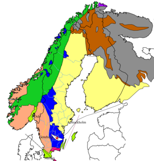
The geology of Sweden is the regional study of rocks, minerals, tectonics, natural resources and groundwater in the country. The oldest rocks in Sweden date to more than 2.5 billion years ago in the Precambrian. Complex orogeny mountain building events and other tectonic occurrences built up extensive metamorphic crystalline basement rock that often contains valuable metal deposits throughout much of the country. Metamorphism continued into the Paleozoic after the Snowball Earth glaciation as the continent Baltica collided with an island arc and then the continent Laurentia. Sedimentary rocks are most common in southern Sweden with thick sequences from the last 250 million years underlying Malmö and older marine sedimentary rocks forming the surface of Gotland.

The Siilinjärvi carbonatite complex is located in central Finland close to the city of Kuopio. It is named after the nearby village of Siilinjärvi, located approximately 5 km west of the southern extension of the complex. Siilinjärvi is the second largest carbonatite complex in Finland after the Sokli formation, and one of the oldest carbonatites on Earth at 2610±4 Ma. The carbonatite complex consists of a roughly 16 km long steeply dipping lenticular body surrounded by granite gneiss. The maximum width of the body is 1.5 km and the surface area is 14.7 km2. The complex was discovered in 1950 by the Geological Survey of Finland with help of local mineral collectors. The exploration drilling began in 1958 by Lohjan Kalkkitehdas Oy. Typpi Oy continued drilling between years 1964 and 1967, and Apatiitti Oy drilled from 1967 to 1968. After the drillings, the laboratory and pilot plant work were made. The mine was opened by Kemira Oyj in 1979 as an open pit. The operation was sold to Yara in 2007.

Located in the Charlotte Belt of North Carolina is the Farmington Gabbro, located in the Mocksville Complex. The Mocksville Complex consist of metamorphosed/unmetamorphosed gabbros, pyroxenites, hornblendites, wehrlites, granites, and diorites. The plutons in this region formed during the Taconic, Acadian, and Alleghanian orogeny starting on the eastern side of Laurentia. These plutons date back to around 400 Ma, consisting of ultramafic, mafic, and felsic rocks but the Farmington Gabbro is the only pluton on the northwest side of the of the complex that is unmetamorphosed.


