Geology of Mercury

Last updated

Caravaggio is an example of a Peak ring impact basin on Mercury. Mercury Double-Ring Impact Basin.png
Caravaggio is an example of a Peak ring impact basin on Mercury.
Several areas on Mercury are extremely dark, such as a small crater within Hemingway crater in the lower right. A Patch of Black On Mercury.jpg
Several areas on Mercury are extremely dark, such as a small crater within Hemingway crater in the lower right.

The geology of Mercury is the scientific study of the surface, crust, and interior of the planet Mercury. It emphasizes the composition, structure, history, and physical processes that shape the planet. It is analogous to the field of terrestrial geology. In planetary science, the term geology is used in its broadest sense to mean the study of the solid parts of planets and moons. The term incorporates aspects of geophysics, geochemistry, mineralogy, geodesy, and cartography. [1]

Contents

Historically, Mercury has been the least understood of all the terrestrial planets in the Solar System. This stems largely from its proximity to the Sun which makes reaching it with spacecraft technically challenging and Earth-based observations difficult. For decades, the principal source of geologic information about Mercury came from the 2,700 images taken by the Mariner 10 spacecraft during three flybys of the planet from 1974 to 1975. These images covered about 45% of the planet’s surface, but many of them were unsuitable for detailed geologic investigation because of high sun angles which made it hard to determine surface morphology and topography. [2] This dearth of information was greatly alleviated by the MErcury Surface, Space ENvironment, GEochemistry, and Ranging (MESSENGER) spacecraft which between 2008 and 2015 collected over 291,000 images [3] covering the entire planet, along with a wealth of other scientific data. The European Space Agency’s (ESA’s) BepiColumbo spacecraft, scheduled to go into orbit around Mercury in 2025, is expected to help answer many of the remaining questions about Mercury’s geology.

Mercury's surface is dominated by impact craters, basaltic rock and smooth plains, many of them a result of flood volcanism, similar in some respects to the lunar maria, [4] [5] and locally by pyroclastic deposits. [6] Other notable features include vents which appear to be the source of magma-carved valleys, often-grouped irregular-shaped depressions termed "hollows" that are believed to be the result of collapsed magma chambers, [7] scarps indicative of thrust faulting, and mineral deposits (possibly ice) inside craters at the poles. Long thought to be geologically inactive, new evidence suggests there may still be some level of activity. [8] [9]

Mercury's density implies a solid iron-rich core that accounts for about 60% of its volume (75% of its radius). [10] Mercury's magnetic equator is shifted nearly 20% of the planet's radius towards the north, the largest ratio of all planets. [11] This shift suggests there being one or more iron-rich molten layers surrounding the core producing a dynamo effect similar to that of Earth. Additionally, the offset magnetic dipole may result in uneven surface weathering by the solar wind, knocking more surface particles up into the southern exosphere and transporting them for deposit in the north. Scientists are gathering telemetry to determine if such is the case. [11]

After having completed the first solar day of its mission in September 2011, more than 99% of Mercury's surface had been mapped by NASA's MESSENGER probe in both color and monochrome with such detail that scientists' understanding of Mercury's geology has significantly surpassed the level achieved following the Mariner 10 flybys of the 1970s. [7]

Difficulties in exploration

Mariner 10 probe Mariner 10.jpg
Mariner 10 probe

Reaching Mercury from Earth poses significant technical challenges, because the planet orbits so much closer to the Sun than does the Earth. A Mercury-bound spacecraft launched from Earth must travel 91 million kilometers into the Sun's gravitational potential well. [12] Starting from the Earth's orbital speed of 30 km/s, the change in velocity (delta-v) the spacecraft must make to enter into a Hohmann transfer orbit that passes near Mercury is large compared to other planetary missions. The potential energy liberated by moving down the Sun's potential well becomes kinetic energy; requiring another large delta-v to do anything other than rapidly pass by Mercury. In order to land safely or enter a stable orbit the spacecraft must rely entirely on rocket motors because Mercury has negligible atmosphere. A direct trip to Mercury actually requires more rocket fuel than that required to escape the Solar System completely. As a result, only two space probes, Mariner 10 and MESSENGER , both by NASA, have visited Mercury so far.

Internal structure of Mercury Mercury's internal structure1.jpg
Internal structure of Mercury

Furthermore, the space environment near Mercury is demanding, posing the double dangers to spacecraft of intense solar radiation and high temperatures.

Historically, a second obstacle has been that Mercury's period of rotation is a slow 58 Earth days, [13] so that spacecraft flybys are restricted to viewing only a single illuminated hemisphere. In fact, unfortunately, even though Mariner 10 space probe flew past Mercury three times during 1974 and 1975, it observed the same area during each pass. This was because Mariner 10's orbital period was almost exactly 3 sidereal Mercury days, and the same face of the planet was lit at each of the close approaches. As a result, less than 45% of the planet's surface was mapped.

Earth-based observations are made difficult by Mercury's constant proximity to the Sun. This has several consequences:

  1. Whenever the sky is dark enough for viewing through telescopes, Mercury is always already near the horizon, where viewing conditions are poor anyway due to atmospheric factors.
  2. The Hubble Space Telescope and other space observatories are usually prevented from pointing close to the Sun for safety reasons (Erroneously pointing such sensitive instruments at the Sun is likely to cause permanent damage).

Mercury's geological history

Mercury - Gravity Anomalies - mass concentrations (red) suggest subsurface structure and evolution. Gravity Anomalies on Mercury.jpg
Mercury – Gravity Anomalies – mass concentrations (red) suggest subsurface structure and evolution.

Like the Earth, Moon and Mars, Mercury's geologic history is divided up into eras. From oldest to youngest, these are: the pre-Tolstojan, Tolstojan, Calorian, Mansurian, and Kuiperian. These ages are based on relative dating only. [14]

After the formation of Mercury along with the rest of the Solar System 4.6 billion years ago, heavy bombardment by asteroids and comets ensued. The last intense bombardment phase, the Late Heavy Bombardment came to an end about 3.8 billion years ago. Some regions or massifs, a prominent one being the one that formed the Caloris Basin, were filled by magma eruptions from within the planet. These created smooth intercrater plains similar to the maria found on the Moon. Later, as the planet cooled and contracted, its surface began to crack and form ridges; these surface cracks and ridges can be seen on top of other features, such as the craters and smoother plains—a clear indication that they are more recent. Mercury's period of volcanism ended when the planet's mantle had contracted enough to prevent further lava from breaking through to the surface. This probably occurred at some point during its first 700 or 800 million years of history.

Since then, the main surface processes have been intermittent impacts.

Timeline

Geology of Mercury

Time unit: millions of years

Surface features

Mercury's surface is overall similar in appearance to that of the Moon, with extensive mare-like plains and heavily cratered terrains similar to the lunar highlands and made locally by accumulations of pyroclastic deposits. [6]

Topography
PIA19420-Mercury-NorthHem-Topography-MLA-Messenger-20150416.jpg
Map of Mercury's northern hemisphere by the MLA instrument on MESSENGER
lowest (purple) to 10 km (6.2 mi) highest (red).

Impact basins and craters

Mercury's Caloris Basin is one of the largest impact features in the Solar System Caloris basin labeled.png
Mercury's Caloris Basin is one of the largest impact features in the Solar System

Craters on Mercury range in diameter from small bowl-shaped craters to multi-ringed impact basins hundreds of kilometers across. They appear in all states of degradation, from relatively fresh rayed-craters, to highly degraded crater remnants. Mercurian craters differ subtly from Lunar craters – the extent of their ejecta blankets is much smaller, which is a consequence of the 2.5 times stronger surface gravity on Mercury. [14]

MASCS spectrum scan of Mercury's surface by MESSENGER Unmasking the Secrets of Mercury.jpg
MASCS spectrum scan of Mercury's surface by MESSENGER
The so-called "Weird Terrain" formed by the Caloris Basin impact at its antipodal point Mercury's 'Weird Terrain'.jpg
The so-called "Weird Terrain" formed by the Caloris Basin impact at its antipodal point

The largest known crater is the enormous Caloris Basin, with a diameter of 1,550 km. [15] A basin of comparable size, tentatively named Skinakas Basin had been postulated from low resolution Earth-based observations of the non-Mariner-imaged hemisphere, but has not been observed in MESSENGER imagery of the corresponding terrain. The impact which created the Caloris Basin was so powerful that its effects are seen on a global scale. It caused lava eruptions and left a concentric ring over 2 km tall surrounding the impact crater. At the antipode of the Caloris Basin lies a large region of unusual, hilly and furrowed terrain, sometimes called "Weird Terrain". The favoured hypothesis for the origin of this geomorphologic unit is that shock waves generated during the impact traveled around the planet, and when they converged at the basin's antipode (180 degrees away) the high stresses were capable of fracturing the surface. [16] A much less favoured idea was that this terrain formed as a result of the convergence of ejecta at this basin's antipode. Furthermore, the formation of the Caloris Basin appears to have produced a shallow depression concentric around the basin, which was later filled by the smooth plains (see below).

Overall about 15 impact basins have been identified on the imaged part of Mercury. Other notable basins include the 400 km wide, multi-ring, Tolstoj Basin which has an ejecta blanket extending up to 500 km from its rim, and its floor has been filled by smooth plains materials. Beethoven Basin also has a similar-sized ejecta blanket and a 625 km diameter rim. [14]

As on the Moon, fresh craters on Mercury show prominent bright ray systems. These are made by ejected debris, which tend to be brighter while they remain relatively fresh because of a lesser amount of space weathering than the surrounding older terrain.

Pit-floor craters

Some impact craters on Mercury have non-circular, irregularly shaped depressions or pits on their floors. Such craters have been termed pit-floor craters, and MESSENGER team members have suggested that such pits formed by the collapse of subsurface magma chambers. If this suggestion is correct, the pits are evidence of volcanic processes at work on Mercury. [9] Pit craters are rimless, often irregularly shaped, and steep-sided, and they display no associated ejecta or lava flows but are typically distinctive in color. For example, the pits of Praxiteles have an orange hue. [17] Thought to be evidence of shallow magmatic activity, pit craters may have formed when subsurface magma drained elsewhere and left a roof area unsupported, leading to collapse and the formation of the pit. Major craters exhibiting these features include Beckett, Gibran, Lermontov, Picasso, and Navoi, among others. [18] It was suggested that these pits with associated brighter and redder deposits may be pyroclastic deposits caused by explosive volcanism. [6]

Interior of Abedin crater Oblique Abedin 2015.png
Interior of Abedin crater

Plains

There are two geologically distinct plains units on Mercury: [14] [19]

The floor of the Caloris Basin is also filled by a geologically distinct flat plain, broken up by ridges and fractures in a roughly polygonal pattern. It is not clear whether they are volcanic lavas induced by the impact, or a large sheet of impact melt. [14]

Tectonic features

Discovery Rupes. Discovery Rupes.jpg
Discovery Rupes.

One unusual feature of the planet's surface is the numerous compression folds which crisscross the plains. It is thought that as the planet's interior cooled, it contracted and its surface began to deform. The folds can be seen on top of other features, such as craters and smoother plains, indicating that they are more recent. [20] Mercury's surface is also flexed by significant tidal bulges raised by the Sun—the Sun's tides on Mercury are about 17% stronger than the Moon's on Earth. [21]

Faculae

Faculae on Mercury are bright areas often surrounding irregular depressions. They are generally interpreted to be pyroclastic in nature. [22] The faculae on Mercury are all named using words in different languages meaning snake.

Terminology

Non-crater surface features are given the following names:

High-albedo polar patches and possible presence of ice

The first radar observations of Mercury were carried out by the radiotelescopes at Arecibo (Puerto Rico) and Goldstone (California, United States), with assistance from the U.S. National Radio Astronomy Observatory Very Large Array (VLA) facility in New Mexico. The transmissions sent from the NASA Deep Space Network site at Goldstone were at a power level of 460 kW at 8.51 GHz; the signals received by the VLA multi-dish array detected points of radar reflectivity (radar luminosity) with depolarized waves from Mercury's north pole.

Radar image of Mercury's north pole. Merc fig2sm.jpg
Radar image of Mercury's north pole.

Radar maps of the surface of the planet were made using the Arecibo radiotelescope. The survey was conducted with 420 kW UHF band (2.4 GHz) radio waves which allowed for a 15 km resolution. This study not only confirmed the existence of the zones of high reflectivity and depolarization, but also found a number of new areas (bringing the total to 20) and was even able to survey the poles. It has been postulated that surface ice may be responsible for these high luminosity levels, as the silicate rocks that compose most of the surface of Mercury have exactly the opposite effect on luminosity.

In spite of its proximity to the Sun, Mercury may have surface ice, since temperatures near the poles are constantly below freezing point: On the polar plains, the temperature does not rise above −106 °C. Craters at Mercury's higher latitudes (discovered by radar surveys from Earth as well) may be deep enough to shield the ice from direct sunlight. Inside the craters, where there is no solar light, temperatures fall to −171 °C. [23]

Despite sublimation into the vacuum of space, the temperature in the permanently shadowed region is so low that this sublimation is slow enough to potentially preserve deposited ice for billions of years.

At the South Pole, the location of a large zone of high reflectivity coincides with the location of the Chao Meng-Fu crater, and other small craters containing reflective areas have also been identified. At the North Pole, a number of craters smaller than Chao-Meng Fu have these reflective properties.

The strength of the radar reflections seen on Mercury are small compared to that which would occur with pure ice. This may be due to powder deposition that does not cover the surface of the crater completely or other causes, e.g. a thin overlying surface layer. However, the evidence for ice on Mercury is not definitive. The anomalous reflective properties could also be due to the existence of deposits of metallic sulfates or other materials with high reflectance.

Possible origin of ice

Mercury is not unique in having craters that stand in permanent shadow; at the south pole of Earth's Moon there is a large crater (Aitken) where some possible signs of the presence of ice have been seen (although their interpretation is disputed). It is thought by astronomers that ice on both Mercury and the Moon must have originated from external sources, mostly impacting comets. These are known to contain large amounts, or a majority, of ice. It is therefore conceivable for meteorite impacts to have deposited water in the permanently shadow craters, where it would remain unwarmed for possibly billions of years due to the lack of an atmosphere to efficiently conduct heat and stable orientation of Mercury's rotation axis.

Mercury
PIA19411-Mercury-WaterIce-Radar-MDIS-Messenger-20150416.jpg
Water ice (yellow) at Mercury's north polar region

Mercury's biological history

Habitability

There may be scientific support, based on studies reported in March 2020, for considering that parts of the planet Mercury may have been habitable, and perhaps that life forms, albeit likely primitive microorganisms, may have existed on the planet. [24] [25]

See also

Related Research Articles

<span class="mw-page-title-main">Mercury (planet)</span> First planet from the Sun

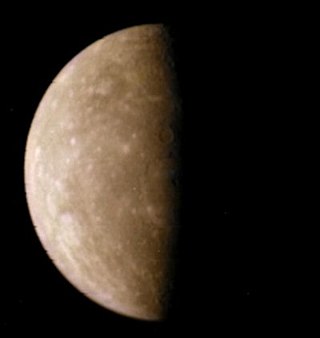
Mercury is the first planet from the Sun and the smallest in the Solar System. In English, it is named after the Roman god Mercurius (Mercury), god of commerce and communication, and the messenger of the gods. Mercury is classified as a terrestrial planet, with roughly the same surface gravity as Mars. The surface of Mercury is heavily cratered, as a result of countless impact events that have accumulated over billions of years. Its largest crater, Caloris Planitia, has a diameter of 1,550 km (960 mi) and one-third the diameter of the planet. Similarly to the Earth's Moon, Mercury's surface displays an expansive rupes system generated from thrust faults and bright ray systems formed by impact event remnants.

<span class="mw-page-title-main">Caloris Planitia</span> Crater on Mercury

Caloris Planitia is a plain within a large impact basin on Mercury, informally named Caloris, about 1,550 km (960 mi) in diameter. It is one of the largest impact basins in the Solar System. "Calor" is Latin for "heat" and the basin is so-named because the Sun is almost directly overhead every second time Mercury passes perihelion. The crater, discovered in 1974, is surrounded by the Caloris Montes, a ring of mountains approximately 2 km (1.2 mi) tall.

<span class="mw-page-title-main">Geology of solar terrestrial planets</span> Geology of Mercury, Venus, Earth, Mars and Ceres

The geology of solar terrestrial planets mainly deals with the geological aspects of the four terrestrial planets of the Solar System – Mercury, Venus, Earth, and Mars – and one terrestrial dwarf planet: Ceres. Earth is the only terrestrial planet known to have an active hydrosphere.

<span class="mw-page-title-main">Borealis quadrangle</span> Quadrangle on Mercury

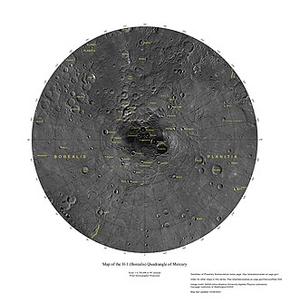
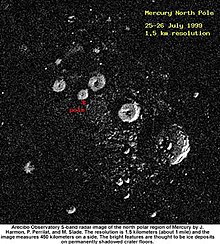
The Borealis quadrangle is a quadrangle on Mercury surrounding the north pole down to 65° latitude. It was mapped in its entirety by the MESSENGER spacecraft, which orbited the planet from 2008 to 2015, excluding areas of permanent shadow near the north pole. Only approximately 25% of the quadrangle was imaged by the Mariner 10 spacecraft during its flybys in 1974 and 1975. The quadrangle is now called H-1.

<span class="mw-page-title-main">Goethe Basin</span> Crater on Mercury

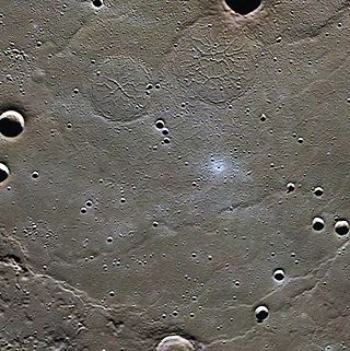
Goethe Basin is an impact basin at 81.4° N, 54.3° W on Mercury approximately 317 kilometers in diameter. It is named after German poet Johann Wolfgang von Goethe.

<span class="mw-page-title-main">Victoria quadrangle</span> Quadrangle on Mercury

The Victoria quadrangle is a region on Mercury from 0 to 90° longitude and 20 to 70 ° latitude. It is designated the "H-2" quadrangle, and is also known as Aurora after a large albedo feature.

<span class="mw-page-title-main">Tolstoj quadrangle</span> Quadrangle on Mercury

The Tolstoj quadrangle in the equatorial region of Mercury runs from 144 to 216° longitude and -25 to 25° latitude. It was provisionally called "Tir", but renamed after Leo Tolstoy by the International Astronomical Union in 1976. Also called Phaethontias.

<span class="mw-page-title-main">Tolstoj (crater)</span> Crater on Mercury

Tolstoj is a large, ancient impact crater on Mercury. It was named after Leo Tolstoy by the IAU in 1976. The albedo feature Solitudo Maiae appears to be associated with this crater.

<span class="mw-page-title-main">Shakespeare quadrangle</span> Quadrangle on Mercury

The Shakespeare quadrangle is a region of Mercury running from 90 to 180° longitude and 20 to 70° latitude. It is also called Caduceata.

The Caloris group is a set of geologic units on Mercury. McCauley and others have proposed the name “Caloris Group” to include the mappable units created by the impact that formed the Caloris Basin and have formally named four formations within the group, which were first recognized and named informally by Trask and Guest.

<span class="mw-page-title-main">Kuiper quadrangle</span> Quadrangle on Mercury

The Kuiper quadrangle, located in a heavily cratered region of Mercury, includes the young, 55-km-diameter crater Kuiper, which has the highest albedo recorded on the planet, and the small crater Hun Kal, which is the principal reference point for Mercurian longitude. Impact craters and basins, their numerous secondary craters, and heavily to lightly cratered plains are the characteristic landforms of the region. At least six multiringed basins ranging from 150 km to 440 km in diameter are present. Inasmuch as multiringed basins occur widely on that part of Mercury photographed by Mariner 10, as well as on the Moon and Mars, they offer a potentially valuable basis for comparison between these planetary bodies.

<span class="mw-page-title-main">Bach quadrangle</span> Quadrangle on Mercury

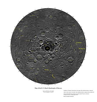
The Bach quadrangle encompasses the south polar part of Mercury poleward of latitude 65° S. It is named after the prominent crater Bach within the quadrangle, which is in turn named after Baroque composer Johann Sebastian Bach. The quadrangle is now called H-15.

<span class="mw-page-title-main">Beethoven quadrangle</span> Quadrangle on Mercury

The Beethoven quadrangle is located in the equatorial region of Mercury, in the center of the area imaged by Mariner 10. Most pictures of the quadrangle were obtained at high sun angles as the Mariner 10 spacecraft receded from the planet. Geologic map units are described and classified on the basis of morphology, texture, and albedo, and they are assigned relative ages based on stratigraphic relations and on visual comparisons of the density of superposed craters. Crater ages are established by relative freshness of appearance, as indicated by topographic sharpness of their rim crests and degree of preservation of interior and exterior features such as crater floors, walls, and ejecta aprons. Generally, topography appears highly subdued because of the sun angle, and boundaries between map units are not clearly defined.

<span class="mw-page-title-main">Discovery quadrangle</span> Quadrangle on Mercury

The Discovery quadrangle lies within the heavily cratered part of Mercury in a region roughly antipodal to the 1550-km-wide Caloris Basin. Like the rest of the heavily cratered part of the planet, the quadrangle contains a spectrum of craters and basins ranging in size from those at the limit of resolution of the best photographs to those as much as 350 km across, and ranging in degree of freshness from pristine to severely degraded. Interspersed with the craters and basins both in space and time are plains deposits that are probably of several different origins. Because of its small size and very early segregation into core and crust, Mercury has seemingly been a dead planet for a long time—possibly longer than the Moon. Its geologic history, therefore, records with considerable clarity some of the earliest and most violent events that took place in the inner Solar System.

<span class="mw-page-title-main">Michelangelo quadrangle</span> Quadrangle on Mercury

The Michelangelo quadrangle is in the southern hemisphere of the planet Mercury, where the imaged part is heavily cratered terrain that has been strongly influenced by the presence of multiring basins. At least four such basins, now nearly obliterated, have largely controlled the distribution of plains materials and structural trends in the map area. Many craters, interpreted to be of impact origin, display a spectrum of modification styles and degradation states. The interaction between basins, craters, and plains in this quadrangle provides important clues to geologic processes that have formed the morphology of the mercurian surface.

<span class="mw-page-title-main">Rembrandt (crater)</span> Crater on Mercury

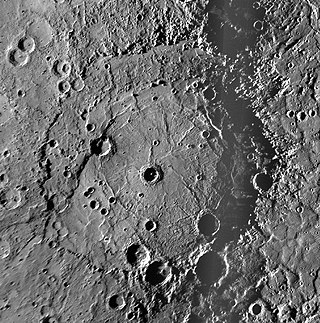
Rembrandt is a large impact crater on Mercury. With a diameter of 716 km it is the second-largest impact basin on the planet, after Caloris, and is one of the larger craters in the Solar System. It was discovered by MESSENGER during its second flyby of Mercury on October 6, 2008. The crater is 3.9 billion years old, and was created during the period of Late Heavy Bombardment. The density and size distribution of impact craters along Rembrandt's rim indicate that it is one of the youngest impact basins on Mercury.

<span class="mw-page-title-main">Raditladi (crater)</span> Crater on Mercury

Raditladi is a large impact crater on Mercury with a diameter of 263 km. Inside its peak ring there is a system of concentric extensional troughs (graben), which are rare surface features on Mercury. The floor of Raditladi is partially covered by relatively light smooth plains, which are thought to be a product of the effusive volcanism. The troughs may also have resulted from volcanic processes under the floor of Raditladi. The basin is relatively young, probably younger than one billion years, with only a few small impact craters on its floor and with well-preserved basin walls and peak-ring structure. It is one of 110 peak ring basins on Mercury.

<span class="mw-page-title-main">Pre-Tolstojan</span>

Pre-Tolstojan, also Pretolstojan Period, refers to the oldest period of the history of Mercury, 4500–3900 MYA. It is the "first period of the Eomercurian Era and of the Mercurian Eon, as well as being the first period in Mercury's geologic history", and refers to its formation and the 600 million or so years in its aftermath. Mercury was formed with a tiny crust, mantle, and a giant core and as it evolved it faced heavy bombardments that created most of the craters and intercrater plains seen on the planet's surface today. Many of the smaller basins and multi-ring basins were created during this period. Considered a "dead" planet, its geology is highly diverse with craters forming the dominant terrain.

Ghost craters on the planet Mercury have tectonic features such as graben and wrinkle ridges. These features were formed by extensional and contractional forces originating in tectonic processes such as uplift and global contraction. The combination of graben and wrinkle ridges inside ghost craters found on Mercury has not been observed on any of the other terrestrial planets.

<span class="mw-page-title-main">Inter-crater plains on Mercury</span>

Inter-crater plains on Mercury are a land-form consisting of plains between craters on Mercury.

References

  1. Greeley, Ronald (1993). Planetary landscapes (2nd ed.). New York: Chapman & Hall. p. 1. ISBN   0-412-05181-8.
  2. Strom, R.G. in “Geology of the Terrestrial Planets,” M.H. Carr, Ed., Special Paper 469, NASA Scientific and Technical Information Branch:Washington D.C., 1984, p. 13. https://www.lpi.usra.edu/publications/books/geologyTerraPlanets/
  3. MESSENGER website. Johns Hopkins Applied Physics Laboratory. https://messenger.jhuapl.edu/Explore/images/impressions/messenger-byTheNumbers-lg.jpg
  4. "Solar System Exploration: Mercury". NASA. Archived from the original on 21 July 2011. Retrieved 17 February 2012.
  5. "MESSENGER Team Presents New Mercury Findings". NASA. Archived from the original on 16 October 2011. Retrieved 16 February 2012.
  6. 1 2 3 Thomas, Rebecca J.; Rothery, David A.; Conway, Susan J.; Anand, Mahesh (16 September 2014). "Long-lived explosive volcanism on Mercury". Geophysical Research Letters. 41 (17): 6084–6092. Bibcode:2014GeoRL..41.6084T. doi: 10.1002/2014GL061224 .
  7. 1 2 "Orbital Observations of Mercury". Johns Hopkins University Applied Physics Lab. Archived from the original on 26 June 2015. Retrieved 16 February 2012.
  8. "The MESSENGER Gamma-Ray Spectrometer: A window into the formation and early evolution of Mercury". Johns Hopkins University Applied Physics Lab. Archived from the original on 12 December 2012. Retrieved 18 February 2012.
  9. 1 2 "Evidence of Volcanism on Mercury: It's the Pits". Johns Hopkins University Applied Physics Lab. Archived from the original on 28 April 2014. Retrieved 16 February 2012.
  10. "Mercury: The Key to Terrestrial Planet Evolution". Johns Hopkins University Applied Physics Lab. Archived from the original on 4 September 2014. Retrieved 18 February 2012.
  11. 1 2 "Mercury's Oddly Offset Magnetic Field". Johns Hopkins University Applied Physics Lab. Archived from the original on 12 December 2012. Retrieved 18 February 2012.
  12. "Topic: 1.2.c Mercury missions | CosmoLearning Astronomy". CosmoLearning. Retrieved 24 July 2023.
  13. "Mercury Fact Sheet". nssdc.gsfc.nasa.gov. Retrieved 24 July 2023.
  14. 1 2 3 4 5 6 7 P. D. Spudis (2001). "The Geological History of Mercury". Workshop on Mercury: Space Environment, Surface, and Interior, Chicago (1097): 100. Bibcode:2001mses.conf..100S.
  15. Shiga, David (30 January 2008). "Bizarre spider scar found on Mercury's surface". NewScientist.com news service.
  16. Schultz, Peter H.; Gault, Donald E. (1975). "Seismic effects from major basin formations on the moon and mercury". The Moon. 12 (2): 159–177. Bibcode:1975Moon...12..159S. doi:10.1007/BF00577875. S2CID   121225801.
  17. "Overlaying Color onto Praxiteles Crater". Johns Hopkins University Applied Physics Lab. Archived from the original on 26 June 2015. Retrieved 16 February 2012.
  18. "A Newly Pictured Pit-Floor Crater". Johns Hopkins University Applied Physics Lab. Archived from the original on 26 June 2015. Retrieved 16 February 2012.
  19. 1 2 3 R.J. Wagner; et al. (2001). "Application of an Updated Impact Cratering Chronology Model to Mercury's Time-Stratigraphic System". Workshop on Mercury: Space Environment, Surface, and Interior, Chicago (1097): 106. Bibcode:2001mses.conf..106W.
  20. Dzurisin, D. (1978). "The tectonic and volcanic history of mercury as inferred from studies of scarps, ridges, troughs, and other lineaments". Journal of Geophysical Research: Solid Earth. 83 (B10): 4883–4906. Bibcode:1978JGR....83.4883D. doi:10.1029/JB083iB10p04883.
  21. Van Hoolst, T.; Jacobs, C. (2003). "Mercury's tides and interior structure". Journal of Geophysical Research: Planets. 108 (E11): 5121. Bibcode:2003JGRE..108.5121V. doi: 10.1029/2003JE002126 .
  22. PYROCLASTIC DEPOSITS ON MERCURY DETECTED WITH MASCS/MESSENGER DATA: IDENTIFICATION THROUGH SPECTRAL CHARACTERIZATION AND PRINCIPAL COMPONENT ANALYSIS (PCA). By A. Galiano, F. Capaccioni, G. Filacchione, C. Carli. 53rd Lunar and Planetary Science Conference (2022).
  23. "Ice on Mercury". National Space Science Data Center. Retrieved 16 February 2012.
  24. Hall, Shannon (24 March 2020). "Life on the Planet Mercury? 'It's Not Completely Nuts' - A new explanation for the rocky world's jumbled landscape opens a possibility that it could have had ingredients for habitability". The New York Times . Retrieved 26 March 2020.
  25. Roddriquez, J. Alexis P.; et al. (16 March 2020). "The Chaotic Terrains of Mercury Reveal a History of Planetary Volatile Retention and Loss in the Innermost Solar System". Scientific Reports . 10 (4737): 4737. Bibcode:2020NatSR..10.4737R. doi: 10.1038/s41598-020-59885-5 . PMC   7075900 . PMID   32179758.

Original references for Spanish article