Georgetown, Quitman County, Georgia

Last updated

Georgetown
City
Georgetown, GA.JPG
Georgetown in 2012.
Quitman County Georgia Incorporated and Unincorporated areas Georgetown Highlighted.svg
Location in Quitman County and the state of Georgia
Coordinates: 31°53′02″N85°06′05″W / 31.88389°N 85.10139°W / 31.88389; -85.10139
CountryUnited States
State Georgia
Counties Quitman
Area
  Total3.9 sq mi (10.2 km2)
  Land2.7 sq mi (7.1 km2)
  Water1.2 sq mi (3.1 km2)
Population
 (2020)
  Total2,235
  Density570/sq mi (220/km2)
ZIP code s
39854
Area code 229

Georgetown is a city in Quitman County, Georgia, United States. It is on the Alabama-Georgia state line next to Walter F. George Lake and across the Chattahoochee River from Eufaula, Alabama. Per the 2020 census, the population was 2,235. [1] In 2006, Georgetown and Quitman County voted to consolidate their governments, becoming the smallest such consolidated entity in the Lower 48 states. [2]

Contents

History

Settled in the early 1830s, Georgetown was first named Tobanana for the nearby creek. The Tobanana Post Office was established on January 10, 1833. On September 21, 1836, the name of the town was changed to "Georgetown" after the historic neighborhood in Washington, D.C. [3]

Georgetown was designated in 1859 as the county seat of Quitman County and was laid out as a town by order of the Inferior Court. The town was incorporated by an act of the legislature on December 9, 1859.

A brigade of federal cavalry, commanded by General Benjamin H. Grierson, camped for a time near Georgetown on the banks of the Tobanana Creek at the close of the American Civil War.

Georgetown was destroyed by fire in 1903; every building except for the post office and three houses were destroyed.

Geography

According to the United States Census Bureau, the city has a total area of 3.9 square miles (10 km2), of which 2.7 square miles (7.0 km2) is land and 1.2 square miles (3.1 km2) (30.46%) is water.

U.S. Route 82, as well as Georgia State Routes 27 and 39, are the main highways through the city. U.S. 82 runs west-east through the city as Middle Street, leading west 3 mi (4.8 km) to Eufaula, Alabama across the Chattahoochee River and southeast 24 mi (39 km) to Cuthbert. GA-39 runs north-south through the city briefly concurrent with U.S. 82, leading north 22 mi (35 km) to Omaha and south 23 mi (37 km) to Fort Gaines. GA-27 begins in the city and leads northeast 24 mi (39 km) to Lumpkin.

Demographics

Historical population
CensusPop.Note
1870 263
1880 245−6.8%
1890 34842.0%
1900 3480.0%
1910 313−10.1%
1920 244−22.0%
1930 34541.4%
1940 3676.4%
1950 55049.9%
1960 5540.7%
1970 86055.2%
1980 9358.7%
1990 913−2.4%
2000 9736.6%
2010 2,513158.3%
2020 2,235−11.1%
U.S. Decennial Census [4]
2010 [5] 2020 [6]
Georgetown CDP, Georgia – Racial and ethnic composition
Note: the US Census treats Hispanic/Latino as an ethnic category. This table excludes Latinos from the racial categories and assigns them to a separate category. Hispanics/Latinos may be of any race.
Race / Ethnicity (NH = Non-Hispanic)Pop 2010 [5] Pop 2020 [6] % 2010% 2020
White alone (NH)1,2651,19050.34%53.24%
Black or African American alone (NH)1,19891747.67%41.03%
Native American or Alaska Native alone (NH)3130.12%0.58%
Asian alone (NH)2120.08%0.54%
Pacific Islander alone (NH)000.00%0.00%
Some Other Race alone (NH)090.00%0.40%
Mixed Race or Multi-Racial (NH)11630.44%2.82%
Hispanic or Latino (any race)34311.35%1.39%
Total2,5132,235100.00%100.00%

In 2000, [7] there were 973 people, 367 households, and 274 families residing in the city. The population density was 355.0 inhabitants per square mile (137.1/km2). By the 2020 census, there were 2,235 people residing in the city, up from 2,513 in 2010. [5] [6]

Education

The Quitman County School District holds grades pre-school to grade twelve. It consists of one elementary-middle school, and one high school that consists of grades ninth through twelfth. [8] The district has 22 full-time teachers and over 314 students. [9]

County students attended Stewart-Quitman High School (now Stewart County High School) from 1978, until Quitman County High opened, [10] in 2009.[ citation needed ]

Related Research Articles

<span class="mw-page-title-main">Clay County, Georgia</span> County in Georgia, United States

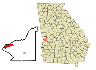
Clay County is a county located in the southwestern part of the U.S. state of Georgia. As of the 2020 census, the population was 2,848, making it the fourth-least populous county in Georgia. The county seat is Fort Gaines.

<span class="mw-page-title-main">Barbour County, Alabama</span> County in Alabama, United States

Barbour County is a county in the southeastern part of the U.S. state of Alabama. As of the 2020 census, the population was 25,223. Its county seat is Clayton. Its largest city is Eufaula. Its name is in honor of James Barbour, who served as Governor of Virginia.

<span class="mw-page-title-main">Russell County, Alabama</span> County in Alabama, United States

Russell County is a county in the southeastern part of the U.S. state of Alabama. As of the 2020 census, the population was 59,183. Its county seat is Phenix City. Its name is in honor of Colonel Gilbert C. Russell, who fought in the wars against the Creek Indians.

<span class="mw-page-title-main">Stewart County, Georgia</span> County in Georgia, United States

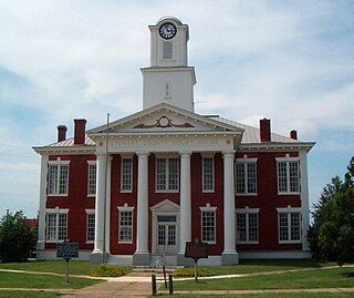
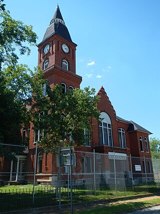
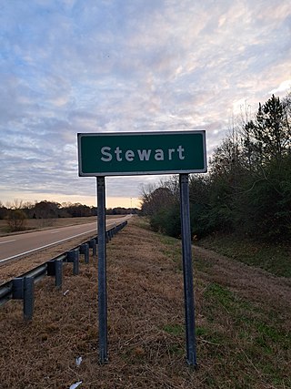
Stewart County is a county located in the west central portion of the U.S. state of Georgia. As of the 2020 census, the population was 5,314. The county seat is Lumpkin. The county was created on December 23, 1830.

<span class="mw-page-title-main">Seminole County, Georgia</span> County in Georgia, United States

Seminole County is a county located in the southwestern corner of U.S. state of Georgia. As of the 2020 census, the population was 9,147. The county seat is Donalsonville.

<span class="mw-page-title-main">Randolph County, Georgia</span> County in Georgia, United States

Randolph County is a county located in the southwestern portion of the U.S. state of Georgia and is considered part of the Black Belt, historically an area of plantations. As of the 2020 census, the population was 6,425, roughly one-third of its peak population in 1910, when there were numerous agricultural workers. The county seat is Cuthbert.

<span class="mw-page-title-main">Quitman County, Georgia</span> County in Georgia, United States

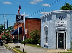
Quitman County is a county located in the southwestern part of the U.S. state of Georgia. As of the 2020 census, the population was 2,235, making it the second-least populous county in Georgia. The county seat is Georgetown. The county was created on December 10, 1858, and named after General John A. Quitman, leader in the Mexican–American War, and once Governor of Mississippi. In November 2006, residents voted to consolidate the city government of Georgetown and the county government of Quitman into a consolidated city-county.

<span class="mw-page-title-main">Miller County, Georgia</span> County in Georgia, United States

Miller County is a county located in the southwestern part of the U.S. state of Georgia. As of the 2020 census, the population was 6,000. The county seat is Colquitt. The county was created on February 26, 1856, and named after Andrew Jackson Miller (1806–56), president of the Medical College of Georgia.

<span class="mw-page-title-main">Chattahoochee County, Georgia</span> County in Georgia, United States

Chattahoochee County, also known as Cusseta-Chattahoochee County, is a county located on the western border in central Georgia. As of the 2020 census, the population was 9,565. The county seat is Cusseta, with which the county shares a consolidated city-county government. The city of Cusseta remains a geographically distinct municipality within Chattahoochee County. The county was created on February 13, 1854.

<span class="mw-page-title-main">Carroll County, Georgia</span> County in Georgia, United States

Carroll County is a county located in the northwestern part of the State of Georgia. As of the 2020 census, its population was 119,148. Its county seat is the city of Carrollton. Carroll County is included in the Atlanta-Sandy Springs-Roswell metropolitan statistical area and is also adjacent to Alabama on its western border.

<span class="mw-page-title-main">Chattahoochee, Florida</span> City in Florida, United States

Chattahoochee is a city in Gadsden County, Florida, United States. Its history dates to the Spanish era. It is part of the Tallahassee, Florida Metropolitan Statistical Area. The population was 2,955 as of the 2020 census, down from 3,652 at the 2010 census.

<span class="mw-page-title-main">Georgetown, Chatham County, Georgia</span> Place in Georgia, United States

Georgetown is an unincorporated community and census-designated place (CDP) in Chatham County, Georgia, United States. The population was 11,916 at the 2020 U.S. census. Georgetown lies across the Little Ogeechee River from Savannah, Georgia, and is a suburban "bedroom community" of Savannah, where most of its adult residents work. It is part of the Savannah Metropolitan Statistical Area.

<span class="mw-page-title-main">Fort Benning South, Georgia</span> CDP in Georgia, United States

Fort Benning South is a former census-designated place (CDP) in Chattahoochee County, Georgia, United States. It is part of the Columbus, Georgia-Alabama metropolitan statistical area. The population was 11,737 at last official census (2000). The area is now part of consolidated Cusseta–Chattahoochee County.

<span class="mw-page-title-main">Fort Gaines, Georgia</span> City in Georgia, United States

Fort Gaines is a city in and the county seat of Clay County, Georgia, United States. It has a population of 1,107 as of the 2010 census.

<span class="mw-page-title-main">Vinings, Georgia</span> Place in Georgia, United States

Vinings is an unincorporated community and census-designated place (CDP) in Cobb County, Georgia, United States that runs along the Chattahoochee River bank across from Buckhead. As of the 2020 census, the CDP had a total population of 12,581. Located next to the affluent Paces section of Buckhead in northwest Atlanta, Vinings is known for its historic sites, shopping districts, proximity to local freeways and The Battery, and nearby nature areas. The United States Postal Service assigns "Atlanta" to the ZIP Code (30339) that includes Vinings.

<span class="mw-page-title-main">Country Club Estates, Georgia</span> Place in Georgia, United States

Country Club Estates is an unincorporated community and census-designated place (CDP) in Glynn County, Georgia, United States. It is part of the Brunswick metropolitan statistical area. The population was 8,373 at the 2020 census, down from 8,545 in 2010.

<span class="mw-page-title-main">Columbus, Georgia</span> Consolidated city-county in the United States

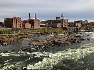
Columbus is a consolidated city-county located on the west-central border of the U.S. state of Georgia. Columbus lies on the Chattahoochee River directly across from Phenix City, Alabama. It is the county seat of Muscogee County, with which it officially merged in 1970; the original merger excluded Bibb City, which joined in 2000 after dissolving its own city charter.

<span class="mw-page-title-main">Lumpkin, Georgia</span> City in Georgia, United States

Lumpkin is a city and county seat of Stewart County, Georgia, United States. Per the 2020 census, the population was 891.

<span class="mw-page-title-main">Stewart, Mississippi</span> Census-designated place in Mississippi, United States

Stewart is a census-designated place and unincorporated community in Montgomery County, Mississippi, United States. As of the 2020 census, it had a population of 99.

References

  1. "Georgetown CDP, Georgia". United States Census Bureau . Retrieved April 15, 2022.
  2. "New Georgetown-Quitman County Government Sets Consolidation Record". Carl Vinson Institute of Government, University of Georgia. Retrieved June 20, 2015.
  3. Krakow, Kenneth K. (1975). Georgia Place-Names: Their History and Origins (PDF). Macon, GA: Winship Press. p. 92. ISBN   0-915430-00-2.
  4. "Decennial Census of Population and Housing by Decades". US Census Bureau.
  5. 1 2 3 "P2 Hispanic or Latino, and Not Hispanic or Latino by Race – 2010: DEC Redistricting Data (PL 94-171) – Georgetown CDP, Georgia". United States Census Bureau .
  6. 1 2 3 "P2 Hispanic or Latino, and Not Hispanic or Latino by Race – 2020: DEC Redistricting Data (PL 94-171) – Georgetown CDP, Georgia". United States Census Bureau .
  7. "U.S. Census website". United States Census Bureau . Retrieved January 31, 2008.
  8. Georgia Board of Education [ permanent dead link ], Retrieved June 25, 2010.
  9. School Stats, Retrieved June 25, 2010.
  10. "Stewart - Quitman County High School is Splitting Up". WTVM. August 14, 2008. Retrieved May 21, 2021.