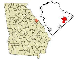
Echols County is a county located in the southeastern part of the U.S. state of Georgia. As of the 2020 census, the population was 3,697. The county seat is Statenville. Since 2008, Statenville is a disincorporated municipality. Echols and Webster counties are the only two counties in Georgia to currently have no incorporated municipalities. The county was established in 1858 and named in honor of Robert Milner Echols (1798–1847).

Georgetown is an unincorporated community and census-designated place (CDP) in Chatham County, Georgia, United States. The population was 11,916 at the 2020 U.S. census. Georgetown lies across the Little Ogeechee River from Savannah, Georgia, and is a suburban "bedroom community" of Savannah, where most of its adult residents work. It is part of the Savannah Metropolitan Statistical Area.

Montgomery is an unincorporated community and census-designated place (CDP) in Chatham County, Georgia, United States. The population was 4,443 at the 2020 United States census, down slightly from 4,523 in 2010. It is a suburb of Savannah and is part of the Savannah metropolitan area.
Evans is an unincorporated community and census-designated place (CDP) in Columbia County, Georgia, United States. It is a suburb of Augusta and is part of the Augusta metropolitan area. The population was 29,011 at the 2010 census, up from 17,727 at the 2000 census.

Martinez is an unincorporated community and census-designated place (CDP) in Columbia County, Georgia, United States. It is a northwestern suburb of Augusta and is part of the Augusta, Georgia metropolitan area. The population was 34,535 at the 2020 census.

Country Club Estates is an unincorporated community and census-designated place (CDP) in Glynn County, Georgia, United States. It is part of the Brunswick metropolitan statistical area. The population was 8,373 at the 2020 census, down from 8,545 in 2010.

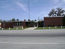
Lakeland is a city and the county seat of Lanier County, Georgia, United States. The city is the county seat of Lanier County. It is part of the Valdosta, Georgia metropolitan statistical area. The population was 2,875 at the 2020 census.

Morse is an unincorporated community and census-designated place (CDP) in Hansford County, Texas, United States. The population was 147 at the 2010 census, down from 172 at the 2000 census.

Knoxville is an unincorporated community and census-designated place in Crawford County, Georgia, United States. It is the county seat of Crawford County. The community is part of the Macon Metropolitan Statistical Area. As of the 2020 census, Knoxville had a population of 65.

Eulonia is an unincorporated community and census-designated place (CDP) in McIntosh County in the U.S. state of Georgia. Part of the Brunswick, Georgia Metropolitan Statistical Area, it is in the Low Country between Savannah and Brunswick near Interstate 95.

Boykin is an unincorporated community and census-designated place (CDP) in Miller County, Georgia, United States. The 2020 census listed a population of 151.
Perkins is a census-designated place and unincorporated community in Jenkins County, Georgia, United States. As of the 2010 census it had a population of 91.

Ponshewaing is an unincorporated community and census-designated place (CDP) in Emmet County in the U.S. state of Michigan. As of the 2010 census, the CDP had a population of 69. It is located within Littlefield Township.

Oden is an unincorporated community and census-designated place (CDP) in Emmet County in the U.S. state of Michigan. As of the 2010 census, the CDP had a population of 363. It is located within Littlefield Township.

New Edinburg is an unincorporated census-designated place in Cleveland County, Arkansas, United States. Per the 2020 census, the population was 134.
Calvary is a census-designated place and unincorporated community in Grady County, Georgia, United States. As of 2020, its population was 129. It is located along Georgia State Route 111, 15 miles (24 km) southwest of Cairo, the Grady County seat. Tallahassee, Florida, is 23 miles (37 km) to the south.
Empire is an unincorporated community and census-designated place in Dodge and Bleckley counties in the U.S. state of Georgia. As of the 2020 census, the CDP had a population of 319.
Godfrey is an unincorporated community and census-designated place in Morgan County, in the U.S. state of Georgia. It first appeared as a CDP in the 2020 Census with a population of 108.
Cogdell is an unincorporated community and census-designated place (CDP) in the northeast corner of Clinch County, Georgia, United States. It is on Georgia State Route 122, 22 miles (35 km) west of Waycross and 24 miles (39 km) east of Lakeland. Homerville, the Clinch county seat, is 10 miles (16 km) to the south.