
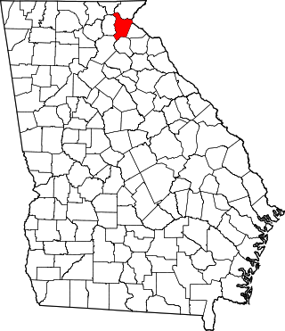
Towns County is a county located in the northeastern part of the U.S. state of Georgia. As of the 2020 census, the population was 12,493. Its county seat is Hiawassee. The county was created on March 6, 1856, and named for lawyer, legislator, and politician George W. Towns.

Jasper County is a county located in the central portion of the U.S. state of Georgia. As of the 2020 census, the population was 14,588, up from 13,900 in 2010. The county seat is Monticello. Jasper County is part of the Atlanta-Sandy Springs-Roswell MSA.
Habersham County is a county located in the northeastern part of the U.S. state of Georgia. As of the 2020 census, the population was 46,031. The county seat is Clarkesville. The county was created on December 15, 1818, and named for Colonel Joseph Habersham of the Continental Army in the Revolutionary War.

Helen is a small city in White County, Georgia, United States, located along the Chattahoochee River. The population was 531 at the 2020 census. The city has now been made over, as a tourist attraction, to look like an old-world Bavarian village. This idea was suggested by John Kollock, an Atlanta artist.

Sweat Mountain is a mountain in far northeastern Cobb County, Georgia, in the suburbs north of Atlanta. The exact GNIS location of its summit is 34°4′1″N84°27′20″W, and it has an official (USGS) elevation of 1,688 ft (515 m) above mean sea level. It is the second-highest point in the county behind Kennesaw Mountain, and second in the core metro Atlanta area, behind Kennesaw Mountain, which is also in Cobb County. It is fifth if the exurban counties further north are considered.

U.S. Route 441 (US 441) is a 939-mile-long (1,511 km) auxiliary route of U.S. Route 41. It extends from US 41 in Miami, Florida to US 25W in Rocky Top, Tennessee. Between its termini, US 441 travels through the states of Florida, Georgia, North Carolina, and Tennessee. The highway acts as a connector between several major urban areas, including Miami, Orlando, Ocala, Gainesville, Athens, and Knoxville. It also crosses the Great Smoky Mountains National Park, where it meets the southwestern end of the Blue Ridge Parkway, and where no trucks or other commercial traffic are allowed.

WNGC is a radio station in North Georgia that plays country music; it was at 95.5 from 1968-1999. It is owned by Cox Media Group and is part of Cox Radio. Its city of license is Arcade with studios in Athens. Its transmitter is in Lula, Georgia.

The Chattooga River is the main tributary of the Tugaloo River.
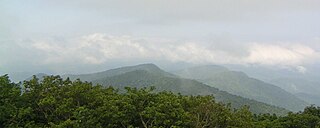
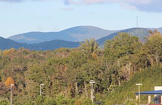
North Georgia is the northern hilly/mountainous region in the U.S. state of Georgia. At the time of the arrival of settlers from Europe, it was inhabited largely by the Cherokee. The counties of north Georgia were often scenes of important events in the history of Georgia. It was the site of many American Civil War battles, including the Battle of Lookout Mountain and the Battle of Chickamauga, leading up to the Atlanta Campaign. Today, particularly in the northeast portion of the region, tourism sustains the local economy.

The Southern Nantahala Wilderness was designated in 1984 and currently consists of 23,473 acres (94.99 km2). Approximately 11,770 acres (47.6 km2) are located in Georgia in the Chattahoochee National Forest and approximately 11,703 acres (47.36 km2) are located in North Carolina in the Nantahala National Forest. The Wilderness is managed by the United States Forest Service and is part of the National Wilderness Preservation System. The highest elevation in the Southern Nantahala Wilderness is the 5,499-foot (1,676 m) peak of Standing Indian Mountain in North Carolina and the lowest elevation is approximately 2,400 feet (730 m). The Appalachian Trail passes through the Wilderness in both states.

Rich Knob, elevation 4,152 feet, is located in Towns County, Georgia. It is part of the Georgia portion of the Southern Nantahala Wilderness and is within the boundaries of the Tallulah Ranger District of the Chattahoochee National Forest. The mountain lies along the Appalachian Trail, which crosses over its eastern flank in Rabun County as it enters North Carolina. Rich Knob also is along the route of The Mountains-To-Sea Trail, East of Rattlesnake Lodge.
Rich Mountain, elevation 4,040 feet (1,230 m), is the highest point in the Rich Mountain Wilderness of the Chattahoochee National Forest in Gilmer County, Georgia. It is the second-highest peak in Gilmer County; only Big Bald Mountain is taller, with its summit at 4,081 feet (1,244 m).
Pine Mountain is an unincorporated community located in eastern Rabun County, Georgia, United States, at an elevation of 1611 feet. It is one of only two Georgia communities located north of South Carolina, due to a quirk of geography: the Chattooga River is the primary tributary of the Savannah River and Tugalo River specified in the 1787 Treaty of Beaufort, but runs perpendicular to them.

The Soque River and its watershed are located entirely within the county boundaries of Habersham County in northeast Georgia. The Soque is a tributary of the Chattahoochee River. Portions of the river run along State Route 197.

Mount Oglethorpe is a mountain located in Pickens County, Georgia, United States. The southernmost peak in the Blue Ridge Mountains, the mountain has an elevation of 3,288 feet (1,002 m), making it the highest point in Pickens County, and the Atlanta Metropolitan Area.

Chenocetah Mountain, known to locals as "Tower Mountain," is located near the towns of Mount Airy and Cornelia, Georgia. The mountain has an elevation of 1,830 feet (560 m). Atop the mountain, the WPA built an observation tower in 1937 for the Forest Service; it is used as a fire tower for observation by rangers. Chenocetah is a Cherokee language word meaning "see all around." Variant names were "Griffin Mountain" and "Tower Mountain".

Northeast Georgia is a region of Georgia in the United States. The northern part is also in the North Georgia mountains or Georgia mountain region, while the southern part is still hilly but much flatter in topography. Northeast Georgia is also served by the Asheville/Spartanburg/Greenville/Anderson market.
The San Gabriel Mountains Trailbuilders (SGMTBs) is a 501(c)(3) non-profit volunteer organization which performs hiking and nature trail building and maintenance within the Los Angeles Gateway District of the United States Forest Service which maintains the Angeles National Forest within the San Gabriel Mountains.
