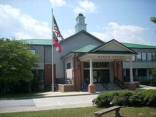
Rabun County is the northeasternmost county in the U.S. state of Georgia. As of the 2010 census, the population was 16,276. The county seat is Clayton.
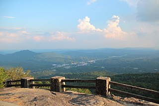
Black Rock Mountain State Park is a 1,743-acre (705 ha) Georgia state park west of Mountain City in Rabun County, Georgia, in Georgia's Blue Ridge Mountains. It is named after its sheer cliffs of dark-colored biotite gneiss. Astride the Eastern Continental Divide at an elevation of 3,640 feet (1,110 m), the park provides many scenic overlooks and 80-mile (130 km) vistas of the southern Appalachian Mountains. On a clear day, four states are visible: Georgia, North Carolina, South Carolina, and Tennessee. In addition to Black Rock Mountain itself, the park includes four other peaks over 3,000 feet (910 m) in elevation, making it the highest state park in Georgia. The park is closed seasonally from December 18 to March 15.

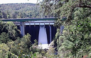
Lake Burton is a 2,775 acre (11.23 km²) reservoir with 62 miles (100 km) of shoreline located in the northeastern corner of Georgia in Rabun County. It is the first lake in a six-lake series called the Tallulah River Watershed that follows the original course of the Tallulah River. The chain begins with Lake Burton as the northernmost lake followed by Lake Seed, Lake Rabun, Lake Tallulah Falls, Lake Tugalo, and Lake Yonah. The lakes are owned and operated by the Georgia Power Company to generate hydroelectric energy for Georgia's largest city, Atlanta. At one time these lakes were the largest producers of electricity in the state of Georgia. At present the lakes provide power only during periods of peak electricity consumption.
Coleman River is a 6.6-mile-long (10.6 km) stream that is located in the Blue Ridge Mountains, mostly within Rabun County, Georgia. It is one of the main tributaries of the Tallulah River. The headwaters of Coleman River are located in Clay County, North Carolina, and the river travels a short distance before crossing into Georgia. The length of Coleman River in Rabun County is approximately 5.4 miles (8.7 km), with about 1.3 miles (2.1 km) traveling through private lands and about 4.1 miles (6.6 km) traveling through the Chattahoochee National Forest. The northern part of Coleman River in Georgia, from an elevation of about 2,800 feet (850 m) northward, together with the portion of Coleman River in North Carolina, is located in the Southern Nantahala Wilderness.
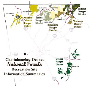
The Tallulah Ranger District is one of the five ranger districts of the Chattahoochee National Forest. The largest portion of the district is located in Rabun County, Georgia, which contains nearly 149,000 acres (600 km2). A portion of the Tallulah Ranger District is also found in Towns County. Both the Appalachian Trail and the Bartram Trail are located in the district.

Dick's Knob or Dicks Knob, with an elevation of 4,620 feet (1,408 m), is the third-highest peak in the State of Georgia if using a 200 ft. prominence rule. It is located in Rabun County, Georgia within the Southern Nantahala Wilderness and is the second-highest mountain in the county.

The Southern Nantahala Wilderness was designated in 1984 and currently consists of 23,473 acres (94.99 km2). Approximately 11,770 acres (47.6 km2) are located in Georgia in the Chattahoochee National Forest and approximately 11,703 acres (47.36 km2) are located in North Carolina in the Nantahala National Forest. The Wilderness is managed by the United States Forest Service and is part of the National Wilderness Preservation System. The highest elevation in the Southern Nantahala Wilderness is the 5,499-foot peak of Standing Indian Mountain in North Carolina and the lowest elevation is approximately 2,400 feet (730 m). The Appalachian Trail passes through the Wilderness in both states.

Horsetrough Mountain, with a summit elevation of 4,045 feet (1,233 m), is located in Union and White counties in northeastern Georgia, USA. It is also within the boundaries of the Chattahoochee National Forest and is part of the Mark Trail Wilderness. The Eastern Continental Divide follows the main ridge line that makes up the mountain, crossing the peak. Water to the south and east of the mountain flows to the Atlantic Ocean, while water to the north and west of the mountain flows to the Gulf of Mexico. Streams from Horsetrough Mountain form some of the headwaters of the Chattahoochee River, and the West Fork Little River. The Appalachian Trail follows the main ridge line of the mountain but does not cross the summit. Horsetrough Falls is located on the southern side of the mountain.
Pine Mountain is an unincorporated community located in eastern Rabun County, Georgia, United States, at an elevation of 1661 feet. It is one of only two Georgia communities located north of South Carolina, due to a quirk of geography: the Chattooga River is the primary tributary of the Savannah River and Tugalo River specified in the 1787 Treaty of Beaufort, but runs perpendicular to them.

Young Lick is a mountain that lies in three Georgia counties, Habersham, Rabun and Towns. Its summit - Young Lick Knob, elevation 3,809 feet (1,161 m), is one of Habersham County's highest points. Young Lick Knob is crossed by the Appalachian Trail.
Seed Lake is a 240-acre (0.97 km²) reservoir with 13 miles (21 km) of shoreline located in Rabun County, in the northeastern corner of Georgia, United States. It is the second lake in a series of six lakes that follow the original riverbed of the Tallulah River. Each lake in the chain is created by hydroelectric dams operated by Georgia Power. Lake Seed is sandwiched between the northernmost lake in the series, Lake Burton, and Lake Rabun. Lake Rabun is followed by Lake Tallulah Falls, Lake Tugalo, and Lake Yonah. The reservoir elevation is listed as 1,765 feet on topographic maps, but Georgia Power considers the lake full at an elevation of 1,752.5 feet.

Caledonia Cascade, sometimes called Cascade Falls, is a 600-foot (180 m) waterfall located in Rabun County, Georgia, USA near the town of Tallulah Falls. This waterfall occurs on a small stream that drops into the Tallulah Gorge near the beginning of the gorge. This tiered waterfall features three drops, the longest of which is 262 feet (80 m). It is best viewed from the hiking trail around the rim of the Tallulah Gorge. After Amicalola Falls, Cascade Falls is the second tallest waterfall in Georgia.
Rocky Knob is a name used to describe eight different mountain peaks located in the North Georgia mountains that are scattered among four different Georgia counties.
Lake Tugalo is a 597-acre (2.42 km2) reservoir with 18 miles (29 km) of shoreline located in the northeastern Georgia in Habersham and Rabun counties, but also lies partially in Oconee County, South Carolina. It is the fifth lake in a six-lake series created by hydroelectric dams operated by Georgia Power that follows the original course of the Tallulah River. The series starts upstream on the Tallulah River with Lake Burton followed by Lake Seed, Lake Rabun, Lake Tallulah Falls and Lake Tugalo, ending with Lake Yonah. The western arm of Lake Tugalo is filled by the Tallulah River and the eastern arm is filled by the Chattooga River. Georgia Power considers the lake full at a surface elevation of 891.5 feet (271.7 m).
Tallulah Falls Lake is a 63-acre (250,000 m2) reservoir with 3.6 miles (5.8 km) of shoreline located in the Northeastern corner of Georgia in Rabun County. It is the fourth and smallest lake in a six-lake series created by hydroelectric dams operated by Georgia Power that follows the original course of the Tallulah River. The series starts upstream on the Tallulah River with Lake Burton followed by Lake Seed, Lake Rabun, Tallulah Falls Lake, Lake Tugalo and Lake Yonah. Georgia Power considers the lake full at a surface elevation of 1,500 feet (460 m).
Germany Valley, located in Rabun County in the U.S. state of Georgia, four miles northwest of Clayton, is a gently sloping valley surrounded by Blue Ridge Mountain peaks. The Germany community is often referred to by local residents as "Germany Mountain," although there is actually no named peak in the area by that name.


