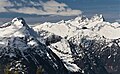
Davis Peak is a mountain just north of Gorge Lake in North Cascades National Park, in the US state of Washington. It is located just south of the Picket Range. While not of particularly high elevation, even for the North Cascades, it is notable for its large, steep local relief, and in particular for its huge Northeast Face, which drops 5,250 ft (1,600 m) in one horizontal mile (1.6 km). This is one of the two largest vertical drops in one horizontal mile in the contiguous United States, the other being the North Face of Kinnerly Peak.

Tomyhoi Peak is a 7,439-foot (2,267-metre) Skagit Range mountain situated one mile south of the Canada–United States border, in the North Cascades of Washington state. It is located west of Mount Larrabee and within the Mount Baker Wilderness, which is part of the Mount Baker-Snoqualmie National Forest. This mountain's toponym was officially adopted in 1913 by the U.S. Board on Geographic Names.

Azurite Peak is an 8,434-foot (2,571-metre) double-summit mountain located at the common boundary point of Okanogan County, Skagit County, and Whatcom County in Washington state. It is part of the Okanogan Range which is a sub-range of the North Cascades Range. Azurite Peak ranks as the 81st-highest summit in the state. Azurite Peak is situated north of Azurite Pass on land administered by the Okanogan–Wenatchee National Forest. The nearest higher neighbor is Tower Mountain, 5.24 miles (8.43 km) to the south-southeast, and Mount Ballard lies 1.97 miles (3.17 km) to the north. Remnants of a small pocket glacier are found on the east aspect. Precipitation runoff from the peak drains north into tributaries of the Skagit River, and south into the Methow River. Topographic relief is significant as the summit rises over 3,000 feet above Mill Creek in one mile (1.6 km). The Pacific Crest Trail traverses the base of Azurite Peak.

Repulse Peak is a 7,923-foot (2,415-metre) mountain summit in the North Cascades in the U.S. state of Washington. It is located on the border of the Stephen Mather Wilderness and North Cascades National Park. It is situated midway between Black Peak and Fisher Peak, and can be seen from the North Cascades Highway. Precipitation runoff from Repulse Peak drains into tributaries of the Skagit River and Stehekin River. Topographic relief is significant as the east face rises over 2,900 feet in 0.53 mile (0.85 km).

The Roost is a 6,705 ft summit in the Picket Range which is a sub-range of the North Cascades of Washington, United States. It is located within North Cascades National Park and Stephen Mather Wilderness, and it is situated one mile north of Mount Ross. Like many North Cascades peaks, The Roost is more notable for its large, steep rise above local terrain than for its absolute elevation. The Roost was first climbed on July 12, 1966 by John and Taffy Roper. The nearest higher neighbor is Glee Peak, 1.76 miles (2.83 km) to the north. Precipitation runoff from the mountain drains into the Skagit River.

Elephant Butte is a remote 7,380-foot-elevation summit located in Whatcom County of Washington, United States. It is situated within North Cascades National Park and Stephen Mather Wilderness, and is part of the Picket Range, a subset of the North Cascades. Like many North Cascades peaks, Elephant Butte is more notable for its large, steep rise above local terrain than for its absolute elevation. Topographic relief is significant as the north aspect rises 5,200 feet above McMillan Creek in one mile, and the south aspect rises 5,000 feet above Stetattle Creek in two miles. Precipitation runoff from the mountain drains to the Skagit River via these two creeks. This geographical feature's name has been officially adopted by the United States Board on Geographic Names.

Red Mountain is a 7,662-foot (2,335-metre) summit in the North Cascades of Washington, United States. It is located in Skagit County, within North Cascades National Park and the Stephen Mather Wilderness. It is situated on a smooth ridge of brick-red color at the western culmination of Ragged Ridge. The nearest higher peak is Cosho Peak, 2.6 miles (4.2 km) to the east-southeast.

Mount Chaval is a craggy 7,127-foot (2,172-metre) mountain summit located in Skagit County of Washington state. Situated within the Glacier Peak Wilderness, Mount Chaval is positioned west of the crest of the North Cascades Range, approximately 15 miles northeast of the town of Darrington. It has two subsidiary peaks, East Peak and Middle Peak, each 7040 ft. The nearest higher neighbor is Snowking Mountain, 2.51 miles (4.04 km) to the northeast. Precipitation runoff from Mount Chaval drains into tributaries of the Skagit River.

Snowking Mountain is a 7,433-foot (2,266-metre) summit located in Skagit County of Washington state. Situated within the Glacier Peak Wilderness, Snowking Mountain is positioned west of the crest of the North Cascades, approximately 18 miles northeast of the town of Darrington. It is set within the Glacier Peak Wilderness, on land managed by Mount Baker–Snoqualmie National Forest. Snowking has two subsidiary peaks, West Peak (7,425 ft), and Middle Peak (7,400 ft). A broad unnamed glacier known colloquially as Snowking Glacier rests on the north face. Downslope of that glacier are Snowking Lake, Found Lake, and Cyclone Lake. Mount Tommy Thompson is three miles to the northwest, and the nearest higher neighbor is Mount Misch, 5.75 miles (9.25 km) to the southeast. Precipitation runoff from Snowking Mountain drains into tributaries of the Skagit River.

Mount Ballard is an 8,371-foot (2,551-metre) double-summit mountain located in eastern Whatcom County of Washington state. It is part of the Okanogan Range which is a sub-range of the North Cascades Range, and the mountain is situated on land administered by the Okanogan–Wenatchee National Forest. Ballard ranks 84th on Washington's highest 100 peaks. The nearest higher neighbor is Azurite Peak, 2.04 miles (3.28 km) to the south. Precipitation runoff from Mount Ballard drains into Mill Creek and Slate Creek, both tributaries of the Skagit River. Topographic relief is significant as the summit rises approximately 4,000 feet above Mill Creek in one mile (1.6 km).

The Chopping Block is a 6,819-foot (2,078-metre) mountain summit located in the Picket Range within North Cascades National Park in the state of Washington. The mountain is officially named Pinnacle Peak on maps, but hardly anyone calls it by that name. The nearest higher peak is Mount Degenhardt, 0.6 mi (0.97 km) to the northeast. The Chopping Block can be seen from the North Cascades National Park Newhalem visitor center, weather permitting. Precipitation runoff from the peak drains into Goodell Creek, a tributary of the Skagit River.

Castle Peak is a prominent 8,343-foot (2,543-metre) mountain summit located in the Hozameen Range of the North Cascades, on the shared border between Okanogan County and Whatcom County of Washington state. The mountain is situated one mile (1.6 km) south of the Canada–United States border, on the Cascade crest, in the Pasayten Wilderness, on land managed by the Okanogan–Wenatchee National Forest. The nearest higher peak is Jack Mountain, 14.8 miles (23.8 km) to the south-southwest. Castle Peak is the second highest summit of the Hozameen Range following Jack Mountain. Castle Peak is the sixth-highest mountain in the Pasayten Wilderness. Precipitation runoff from the mountain drains east into Castle Creek, a tributary of the Similkameen River, or west into tributaries of the Skagit River. Topographic relief is significant as the summit rises nearly 3,000 feet above Crow Creek in 0.75 mile (1.2 km).
Twin Needles are a pair of 7,936-foot (2,419-metre) and 7,840+ ft spires located in the remote and rugged Picket Range within North Cascades National Park in the state of Washington. The peaks are situated 0.55 mi (0.89 km) west of Mount Terror which is the nearest higher peak. The Mustard Glacier lies on the northern slope of the peaks, and Himmelhorn lies immediately west. The first ascent of Twin Needles was made on August 17, 1932, by William Degenhardt, James Martin, and Herb Strandberg. Twin Needles can be seen from the 100 meter Sterling Munro Trail located behind the park's Newhalem Visitor Center.

Skagit Peak is a 6,824-foot (2,080-metre) mountain summit located in the North Cascades, in Whatcom County of Washington state. It is situated on the western side of the Cascade crest, at the western edge of the Pasayten Wilderness, on land managed by the Okanogan–Wenatchee National Forest. Skagit Peak is part of the Hozameen Range, a subset of the North Cascades which also includes Hozomeen Mountain to the north, and Jack Mountain to the south. Precipitation runoff from this mountain drains into the Skagit River via Three Fools Creek and Ross Lake.

Gabriel Peak is a prominent 7,920-foot (2,410 m)-elevation mountain summit located in North Cascades National Park, in Skagit County of Washington state. It is part of the North Cascades which is a subset of the Cascade Range. The nearest higher neighbor is Cosho Peak, 2.7 miles (4.3 km) to the south, Beebe Mountain is set 2.5 miles (4.0 km) to the north, and Red Mountain is 3 miles (4.8 km) to the southwest. Precipitation runoff from this feature drains to Ross Lake via Gabriel and Panther Creeks. Like many North Cascade peaks, Gabriel Peak is more notable for its large, steep rise above local terrain than for its absolute elevation. Topographic relief is significant as it rises 4,700 feet (1,400 m) above the Panther Creek valley in approximately one mile. This geographical feature is named after the archangel Gabriel, which is a reference to Tommy Rowland who settled in the Skagit River area in 1895 and later pronounced himself the "Prophet Elisha." Mount Prophet, Genesis Peak, and nearby Elija Ridge were also named in association with Rowland.

Mount Tommy Thompson is a 6,780-foot-elevation (2,070-meter) mountain summit located in Skagit County of Washington state. It is situated eight miles southeast of the town of Marblemount, within the Glacier Peak Wilderness, on land managed by Mount Baker–Snoqualmie National Forest, on the west slopes of the North Cascades Range. The nearest higher named neighbor is Snowking Mountain, 3.16 miles (5.09 km) to the southeast. Topographic relief is significant as the southwest aspect rises 3,670 feet above Slide Lake in less than two miles. Precipitation runoff from Mount Tommy Thompson drains into tributaries of the Skagit River.

Rhino Butte is a remote 6,914-foot-elevation summit located in Whatcom County of Washington, United States. It is situated within North Cascades National Park and Stephen Mather Wilderness, and is part of the Picket Range, a subset of the North Cascades. Like many North Cascades peaks, Rhino Butte is more notable for its large, steep rise above local terrain than for its absolute elevation. Topographic relief is significant as the north aspect rises 4,350 feet above McMillan Creek in one mile, and the south aspect rises 4,700 feet above Stetattle Creek in two miles. Precipitation runoff from the mountain drains to the Skagit River via these two creeks. The nearest higher neighbor is Elephant Butte, 1.27 mile to the east-northeast, with Hippo Butte (6,889 ft) between the two. A high alpine ridge connects Rhino to McMillan Spire, 1.7 mile to the west-southwest, and Azure Lake lies below this ridge. The first ascent of the summit was made October 15, 1978, by John Roper. This geographical feature's name has not yet been officially adopted by the United States Board on Geographic Names.

Le Conte Mountain is a 7,762-foot-elevation (2,366-meter) summit located on the shared boundary of Skagit County and Chelan County in Washington state. It is positioned on the crest of the North Cascades Range, and is set within the Glacier Peak Wilderness. Le Conte Mountain is situated on the shared border of Mount Baker-Snoqualmie National Forest and Okanogan-Wenatchee National Forest. Access to the peak is via the Ptarmigan Traverse. The nearest higher neighbor is Sentinel Peak, 1.87 miles (3.01 km) to the south-southeast, and Spider Mountain is 2.4 miles (3.9 km) to the northeast. The Le Conte Glacier and South Cascade Glacier lie to the south of the peak. Precipitation runoff on the east side the mountain drains into Flat Creek which is a tributary of the Stehekin River, while precipitation drains into headwaters of the South Fork Cascade River from the west side. Topographic relief is significant as the southwest aspect rises nearly 2,500 feet above South Cascade Lake in less than one-half mile, and the northeast aspect rises 3,200 feet above Flat Creek in one mile.
Mount Buckindy is a remote 7,320-foot-elevation (2,230-meter) mountain summit located in the North Cascades, in Skagit County of Washington state. It is the second-highest point of the Buckindy Range, or Buckindy Ridge. It is set in the Glacier Peak Wilderness on land managed by the Mount Baker-Snoqualmie National Forest. It is situated 20 miles east-northeast of Darrington, Washington, and 17 miles north-northwest of Glacier Peak which is one of the Cascade stratovolcanoes. Precipitation runoff from Mount Buckindy drains south to the Suiattle River via Buck Creek and Downey Creek, and north to the Cascade River via Kindy Creek. Topographic relief is significant as the summit rises 4,700 feet above Kindy Creek in less than two miles. The mountain's toponym is a portmanteau of Buck and Kindy Creeks, and has been officially adopted by the United States Board on Geographic Names.

Little Devil Peak is a 6,985-foot-elevation (2,129 m) mountain summit located in Skagit County of Washington state. It is set within North Cascades National Park and Stephen Mather Wilderness, where it is situated 3.1 miles northeast of Lookout Mountain. Little Devil is the second-highest peak of Teebone Ridge, and other peaks on this ridge include line parent Big Devil Peak, Fallen Angel, and The Trapezoid. Precipitation runoff from the mountain drains into tributaries of the Skagit River. Like many North Cascades peaks, it is more notable for its large, steep rise above local terrain than for its absolute elevation. Topographic relief is significant as the south aspect rises 5,400 feet above Marble Creek in three miles, and the east aspect rises 4,200 feet above Newhalem Creek in approximately 1.5 mile.