
Klawatti Peak is located in North Cascades National Park in the U.S. state of Washington. Klawatti Peak is a nunatak, a peak surrounded by glaciers. These are Klawatti Glacier to the east, McAllister Glacier to the northwest and Inspiration Glacier to the south.
Gunn Peak is a 6,244-foot (1,903-metre) mountain summit located in Snohomish County, Washington. The mountain is part of the Cascade Range. Gunn Peak is the highest point of the Wild Sky Wilderness. The mountain was named for homesteader/miner Amos Gunn who started the nearby town of Index, Washington, and also named nearby Mount Index. Precipitation runoff from the mountain drains into tributaries of the Skykomish River.

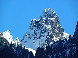
Tomyhoi Peak is a 7,439-foot (2,267-metre) Skagit Range mountain situated one mile south of the Canada–United States border, in the North Cascades of Washington state. It is located west of Mount Larrabee and within the Mount Baker Wilderness, which is part of the Mount Baker-Snoqualmie National Forest. This mountain's name was officially adopted in 1913 by the U.S. Board on Geographic Names.

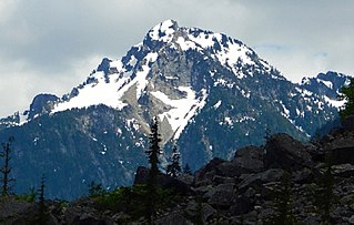
Trapper Mountain is a 7,530-foot (2,300-metre) summit located in Chelan County of Washington state. It is part of the North Cascades Range. Trapper Mountain is situated southeast of Cascade Pass on the shared border of North Cascades National Park and Glacier Peak Wilderness. The nearest higher peak is Hurry-up Peak, 0.92 miles (1.48 km) to the west. Surface runoff from the mountain drains into Trapper Lake and tributaries of the Stehekin River.

Mix-up Peak, also known as Mixup Peak, is a 7,440-foot (2,270-metre) mountain summit located on the shared boundary of Skagit County and Chelan County in Washington state. It is part of the North Cascades Range and is situated one mile south of Cascade Pass on the shared border of North Cascades National Park and Glacier Peak Wilderness. The nearest higher peak is Magic Mountain, 1.02 miles (1.64 km) to the east-southeast. Mix-up Peak is at the northern end of the Ptarmigan Traverse which is an alpine route to remote mountains such as Mount Formidable and Dome Peak. The Cache Glacier occupies a cirque below its eastern flank. Surface runoff on the east side the mountain drains into the Stehekin River, whereas precipitation runoff drains into the Cascade River from the west side.

Repulse Peak is a 7,923-foot (2,415-metre) mountain summit in the North Cascades in the U.S. state of Washington. It is located on the border of the Stephen Mather Wilderness and North Cascades National Park. It's situated midway between Black Peak and Fisher Peak, and can be seen from the North Cascades Highway. Precipitation runoff from Repulse Peak drains into tributaries of the Skagit River and Stehekin River.
Sheep Mountain is a 6,166-foot-elevation (1,879-meter) summit near the western edge of the North Cascades, in Snohomish County of Washington state. It is located one mile east of Barlow Pass along the Mountain Loop Highway near the Monte Cristo area. It is situated on land administered by the Mount Baker-Snoqualmie National Forest. Back in the old mining days of the late 1800s, the long sub-range stretching from Cadet Peak to Sheep Mountain was known as Pride of the Mountains Range. Precipitation runoff from the mountain drains into tributaries of the Sauk River.

Rainy Peak is a 7,768 ft (2,368 m) summit in the Cascade Range in the U.S. state of Washington. It is located 3 kilometers south of Rainy Pass and one kilometer southeast of Frisco Mountain on the borders of the Stephen Mather Wilderness and North Cascades National Park. Its nearest higher peak is Corteo Peak, 2.33 mi (3.75 km) to the northwest. Precipitation runoff from Rainy Peak drains into Rainy Lake and tributaries of Bridge Creek. The retreating Lyall Glacier in its north cirque contributes to waterfalls which tumble 1,000 ft (300 m) into Rainy Lake.

Hurry-up Peak is a 7,821-foot-elevation summit located on the shared boundary of Skagit County and Chelan County in Washington state. It is positioned on the crest of the North Cascades Range, and is set at the northern end of the Ptarmigan Traverse. Hurry-up Peak is situated southeast of Cascade Pass on the shared border of North Cascades National Park and Glacier Peak Wilderness. The nearest higher peak is Spider Mountain, 1.49 miles (2.40 km) to the south, with Magic Mountain 0.83 miles (1.34 km) to the north, and Trapper Mountain 0.7 miles (1.1 km) to the east. The S Glacier rests on the eastern flank of the peak and meltwater from it drains into Trapper Lake. Precipitation runoff on the east side the mountain drains into tributaries of the Stehekin River, while precipitation drains into the Cascade River from the west side. Ess Mountain and S Mountain are variant names for Hurry-up Peak. This geographical feature's name was officially adopted in 1969 by the U.S. Board on Geographic Names.

Preacher Mountain is a broad summit located in King County of Washington state. It's located at the western edge of the Cascade Range and is within the Alpine Lakes Wilderness on land managed by Mount Baker-Snoqualmie National Forest. The nearest higher peak is Kaleetan Peak, 3.11 miles (5.01 km) to the southeast. The Pulpit is situated 2.19 miles to the northwest. Precipitation runoff from the mountain drains into tributaries of the Snoqualmie River.

Summit Chief Mountain is a 7,464-foot (2,275-meter) mountain summit located on the county line separating King County and Kittitas County in Washington state. It is entirely within the Alpine Lakes Wilderness, on land managed by Mount Baker-Snoqualmie National Forest. Summit Chief Mountain is situated on the crest of the Cascade Range, nine miles northeast of Snoqualmie Pass. Precipitation runoff from the west side of the mountain drains into tributaries of the Snoqualmie River, whereas the east side drains into tributaries of the Yakima River. The nearest higher peak is Chimney Rock, 1.29 miles (2.08 km) to the southwest.

Spider Mountain is an 8,286-foot (2,526-metre) mountain summit located in the Glacier Peak Wilderness in western Chelan County of Washington state. It is part of the North Cascades, which is a subset of the Cascade Range. Meltwater from the Spider Glacier on the steep north face, and other surface runoff from the mountain drains into Flat Creek, which is a tributary of the Stehekin River. The nearest higher neighbor is Mount Formidable 1.5 miles (2.4 km) to the west. The Middle Cascade Glacier lies between these two mountains, and the Ptarmigan Traverse passes through also.

Napeequa Peak is an 8,073-foot (2,461-metre) pyramidal mountain summit located in the Glacier Peak Wilderness of the North Cascades in Washington state. The mountain is situated on the crest of the Cascade Range, on the shared border of Snohomish County and Chelan County, also straddling the boundary between the Mount Baker-Snoqualmie National Forest and the Wenatchee National Forest. Its nearest neighbor is Cirque Mountain, 0.3 mi (0.48 km) to the north, and the nearest higher peak is Buck Mountain, 2.56 mi (4.12 km) to the east-southeast. Precipitation runoff from the peak drains east to the headwaters of Napeequa River; or west into the Suiattle River. The mountain's name is taken from the river's name, which was applied by Albert Hale Sylvester (1871-1944), a pioneer surveyor, explorer, topographer, and forest supervisor in the Cascades.

Monument Peak is an 8,597-foot (2,620-metre) mountain summit located in western Okanogan County in Washington state. It is part of the Okanogan Range which is a sub-range of the North Cascades. The mountain is situated in the Pasayten Wilderness, on land administered by the Okanogan–Wenatchee National Forest. The nearest higher peak is Mount Lago, 2.42 miles (3.89 km) to the north. Precipitation runoff from Monument Peak drains east into Monument Creek, and west into Eureka Creek, which are both part of the Methow River drainage basin.

Windy Peak is an 8,333-foot (2,540-metre) mountain summit located in Okanogan County in Washington state. It is part of the Okanogan Range which is a sub-range of the North Cascades and Cascade Range. The mountain is situated 5 miles (8.0 km) south of the Canada–United States border, on the east side of the Cascade crest, in the Pasayten Wilderness, on land managed by the Okanogan–Wenatchee National Forest. The nearest higher peak is Haystack Mountain, 9.24 miles (14.87 km) to the northwest in Canada. Precipitation runoff from Windy Peak drains into tributaries of the Methow River and Similkameen River.

Tiffany Mountain is an 8,245-foot (2,513-metre) mountain summit located in Okanogan County in Washington state. It is the highest point in the Tiffany Range, which is a sub-range of the Okanogan Range. The mountain is situated on the east side of the Cascade crest, on land managed by the Okanogan–Wenatchee National Forest. The nearest higher peak is Windy Peak, 18 miles (29 km) to the north. Precipitation runoff from Tiffany Mountain drains into tributaries of the Columbia River.

The Temple is an 8,292-foot (2,527-metre) granite mountain summit located in Chelan County of Washington state. The Temple is part of The Enchantments, set within the Alpine Lakes Wilderness. The Temple belongs to the Stuart Range which is a subset of the Cascade Range. The nearest higher peak is Enchantment Peak, 1.55 miles (2.49 km) to the west, and the nearest town is Leavenworth, 8 miles (13 km) to the northeast. The mountain hosts many granite spires with names like The High Priest, The Boxtop, Flake Tower, Comet Spire, Razorback Spire, The Meteor, The Professor, Lighthouse Tower, Black Pyramid, and the most recognizable Prusik Peak. The highest point of the mountain is called Mt. Temple. Precipitation runoff from the mountain drains into Snow Creek which is a tributary of Icicle Creek.

Tenpeak Mountain is an 8,200+ ft granitic mountain summit located in the Glacier Peak Wilderness of the North Cascades in Washington state. Fred Beckey's Cascade Alpine Guide has the elevation of the mountain as 8,281 feet. Tenpeak is situated on the crest of the Cascade Range, on the shared border of Snohomish County and Chelan County, also straddling the boundary between the Mount Baker-Snoqualmie National Forest and the Wenatchee National Forest. Its nearest higher neighbor is Luahna Peak, 2.5 mi (4.0 km) to the southeast. Topographic relief is significant since the northern aspect of the mountain rises 4,200 feet above the Suiattle Valley in approximately 1.5 mi (2.4 km). This mountain has small, unnamed, hanging glaciers in cirques surrounding the summit, and the terminus of the Honeycomb Glacier lies below the western base of the mountain. Precipitation runoff from the mountain and meltwater from the glaciers drains south into White River; or north into the Suiattle River. This mountain's descriptive name was suggested by The Mountaineers, and was officially adopted in 1918 by the U.S. Board on Geographic Names. The first ascent was made September 21, 1940, by Lloyd Anderson and Tom Campbell.

Jackita Ridge is a prominent 7,350 ft (2,240 m) ridge located in the Pasayten Wilderness, in Whatcom County of Washington state. It is part of the Hozameen Range which is a subset of the North Cascades. The highest point is called Jackita Peak, and the Jackita Ridge Trail traverses below the west aspect of this summit, providing access for an off-trail scramble to the top. The nearest higher neighbor is Crater Mountain, 3.9 miles (6.3 km) to the southwest, Jack Mountain is set 4.77 miles (7.68 km) to the west, and McKay Ridge is 5.7 miles (9.2 km) to the south. Precipitation runoff from this ridge drains to Ross Lake via Devils Creek and Canyon Creek, which are part of the Skagit River drainage basin. The first ascent may have been made in 1926 by the United States Coast and Geodetic Survey, which placed a Jackita benchmark.
Trappers Peak is a 5,966-foot (1,818 m) elevation mountain summit located in the North Cascades of Washington state. It is situated within North Cascades National Park, Stephen Mather Wilderness, and Whatcom County. It rises steeply above Lower Thornton Lake which is set at the southwestern face of the mountain. Like many North Cascades peaks, Trappers Peak is more notable for its large, steep rise above local terrain than for its absolute elevation. Topographic relief is significant as the southeast aspect rises 5,500 feet (1,700 m) above the North Cascades Highway in approximately two miles. The nearest higher neighbor is Thornton Peak, 1.5 miles (2.4 km) to the northwest, Mount Triumph is two miles to the northwest, and Newhalem is three miles to the east-southeast. Precipitation runoff from the mountain drains into tributaries of the Skagit River. The summit of Trappers Peak is known for its grand view of the jagged peaks of the Picket Range.


