Gonzales, Louisiana

Last updated

Gonzales, Louisiana
City of Gonzales
Gonzales, Louisiana (3922472222).jpg
2009 aerial photo of Gonzales
Ascension Parish Louisiana Incorporated and Unincorporated areas Gonzales Highlighted.svg
Location of Gonzales in Ascension Parish, Louisiana.
Louisiana in United States (US48).svg
Location of Louisiana in the United States
Coordinates: 30°13′38″N90°55′11″W / 30.22722°N 90.91972°W / 30.22722; -90.91972
CountryUnited States
StateLouisiana
Parish Ascension
Named for Tee Joe Gonzales
Government
  Type Mayor-council
  MayorBarney Arceneaux
  Police ChiefSherman Jackson (both elected since 2012)
Area
[1]
  Total9.25 sq mi (23.96 km2)
  Land9.14 sq mi (23.68 km2)
  Water0.11 sq mi (0.28 km2)
Elevation
10 ft (3 m)
Population
 (2020)
  Total12,231
  Density1,337.89/sq mi (516.58/km2)
Time zone UTC-6 (CST)
  Summer (DST) UTC-5 (CDT)
ZIP code
70737
Area code 225
FIPS code 22-29850
Website www.gonzalesla.com

Gonzales is a city in Ascension Parish, Louisiana, United States. As of the 2020 census, it has a population of 12,231. [2] Known as the "Jambalaya Capital of the World", it is famous for its annual Jambalaya Festival, which was first held in 1968. Stephen "Steve" F. Juneau came up with the idea for the Jambalaya Festival and served as the first president of the Jambalaya Festival Association. [3]

Contents

History

Early European settlers of the area that was developed as Gonzales were, for the most part, of French and Spanish ancestry. They settled among the Houma Indians who lived in the area.

Among the projects and plans carried out by Luis de Unzaga ("Le Conciliateur") while he was governor of Louisiana between 1769 and 1777 was the promotion of new settlements by Europeans; among them were French Acadians and Málaga in the fertile Mississippi region, and more specifically in the Unzaga Post or "Puesto de Unzaga" that he created in 1771 in Pointe Coupee, the parish of Saint Gabriel in 1773 and Fort Manchac in 1776; the Gonzales people occupied land at the confluence of the aforementioned European settlements. [4]

By 1851, the small European settlement still had only ten residents. A school was established in 1855 by Adlard Gautreaux for the European-American children in the area. By 1886, the settlement had grown, and the citizens of the community elected "Big" José Gonzáles as their sheriff. José's son, Joseph "Tee-Joe" (for Petit Joe) Gonzales, opened a general store and post office in May 1887. The post office became known as the Gonzales Post Office.

Construction of the railroad to the village stimulated the growth of Gonzales. When the Louisiana Railway and Navigation Company (LR&N) constructed its rail line through the area, the local post office was already named Gonzales. The rail company executives wanted to name their station Edenborn, after the company's owner, Willam Edenborn. The company also wanted to move the station north of the area to New River, Louisiana, then called Belle Hellene. After local residents filed protests with the Louisiana Railroad Commission, the railroad company was ordered to leave the station at Gonzales. The LR&N still tried to change the name to Edenborn. But the residents continued to protest and persuaded the Louisiana Legislature to pass a law requiring railroad companies to name their railroad stations the same as the local post offices.

Gonzales was laid out and subdivided in 1906. [5] It was officially incorporated as a village in 1922. Joseph Gonzales was elected as the first mayor. The village continued to grow, with transportation improved by construction of Airline Highway.

Governor Earl K. Long proclaimed Gonzales as a town in 1952, during his term. The town held its first Jambalaya Festival in 1968. Governor John J. McKeithen marked the occasion by proclaiming Gonzales as the "Jambalaya Capital of the World".

Following the growth of industrial corporations in the area, the town was chartered by the state legislature as a city in 1977.

Gonzales became better known in 2005, after the widespread destruction caused by Hurricane Katrina. The National Guard, and HSUS and other animal rescue groups, established their bases at the fairground in Gonzales. This became their main search and rescue headquarters, as well as the site for holding pets pending return to their families; the animals were rescued from New Orleans and many other locations. Some people were reunited with their lost pets at this site.

Geography

Gonzales is located at 30°13′38″N90°55′11″W / 30.22722°N 90.91972°W / 30.22722; -90.91972 (30.227128, -90.919771). [6] According to the United States Census Bureau, the city has a total area of 8.5 square miles (22.0 km2), of which 8.4 square miles (21.7 km2) is land and 0.12 square miles (0.3 km2), or 1.27%, is water. [7]

Climate

Gonzales has a subtropical climate, with hot summers and mild winters. The area is subject to potential severe weather year-round, with snowfall being rare for the city. Hurricanes also pose a threat to the area due to its proximity to the coastline of southeast Louisiana. In September 2008, Hurricane Gustav brought 80+ mph winds to the area with gusts over 100 mph.

Demographics

Historical population
CensusPop.Note
1930 462
1940 85785.5%
1950 1,64291.6%
1960 3,25298.1%
1970 4,51238.7%
1980 7,28761.5%
1990 7,003−3.9%
2000 8,15616.5%
2010 9,78119.9%
2020 12,23125.0%
U.S. Decennial Census [8]
Gonzales racial composition as of 2020 [9]
RaceNumberPercentage
White (non-Hispanic)4,43236.24%
Black or African American (non-Hispanic)5,73046.85%
Native American 330.27%
Asian 1010.83%
Pacific Islander 40.03%
Other/Mixed 3532.89%
Hispanic or Latino 1,57812.9%

In 2000, there were 8,156 people, 2,966 households, and 2,156 families residing in the city. [10] The population density was 974.2 inhabitants per square mile (376.1/km2). There were 3,332 housing units at an average density of 398.0 per square mile (153.7/km2). As of the 2020 United States census, there were 12,231 people, 4,159 households, and 2,807 families residing in the city.

At the 2000 census, the racial makeup of the city was 65.40% White, 31.25% African American, 0.22% Native American, 0.61% Asian, 0.01% Pacific Islander, 1.64% from other races, and 0.86% from two or more races. Hispanic or Latino of any race were 3.62% of the population. By 2020, its racial makeup was 36.24% non-Hispanic white, 46.85% African American, 0.27% Native American, 0.83% Asian, 0.03% Pacific Islander, 2.89% multiracial, and 12.9% Hispanic or Latino of any race, [9] reflecting state and nationwide trends of greater diversification. [11] [12]

In 2000, there were 2,966 households, out of which 36.3% had children under the age of 18 living with them, 51.6% were married couples living together, 17.0% had a female householder with no husband present, and 27.3% were non-families. 23.0% of all households were made up of individuals, and 6.9% had someone living alone who was 65 years of age or older. The average household size was 2.68 and the average family size was 3.18.

In the city, the population was spread out, with 27.4% under the age of 18, 10.1% from 18 to 24, 30.0% from 25 to 44, 22.3% from 45 to 64, and 10.2% who were 65 years of age or older. The median age was 34 years. For every 100 females, there were 91.1 males. For every 100 females age 18 and over, there were 89.3 males.

The median income for a household in the city was $38,173, and the median income for a family was $43,117 in 2000. Males had a median income of $38,731 versus $22,168 for females. The per capita income for the city was $17,690. About 14.9% of families and 16.6% of the population were below the poverty line, including 23.6% of those under age 18 and 14.5% of those age 65 or over. The median household income as of 2021's American Community Survey estimates increased to $59,108. [13]

Government

The city is governed by a mayor-council form of government. The mayor is elected at-large, and the five council members are elected from city wide at large single-member divisions, One city council division is reserved for African American candidates. The Chief of Police is elected.The current mayor of Gonzales is Barney Arceneaux.

Legislative delegation

District 59 State Representative Tony Bacala of Ascension Parish is a retired law enforcement officer,State Senator Eddie Lambert a family law attorney who represents Ascension, Livingston, St. James, and St. John the Baptist

Edward Joseph Price, an African-American Democrat and a Gonzales businessman, has held the District 58 House seat for Ascension, Iberville and St. James parishes since 2012. [14] Another District 58 representative was Melvin Irvin, a black educator and businessman from Gonzales, who held the seat from 1984 to 1992. He died in 2014.

State Representative Randal Gaines, of St. John the Baptist Parish, formerly resided in Gonzales. [15]

National Guard

Gonzales is home to the 922nd engineer vertical construction company, which is part of the 528th engineer battalion, 225th engineer brigade. 922nd EVCC plays a pivotal role in providing humanitarian relief during natural disasters within the United States, along with remaining ready to deploy anywhere in the world as they are needed.

Notable people

Sister cities

Gonzales has one sister city, as designated by Sister Cities International:

See also

Related Research Articles

<span class="mw-page-title-main">Pointe Coupee Parish, Louisiana</span> Parish in Louisiana, United States

Pointe Coupee Parish is a parish located in the U.S. state of Louisiana. As of the 2020 census, the population was 20,758. The parish seat is New Roads.

<span class="mw-page-title-main">East Baton Rouge Parish, Louisiana</span> Parish in Louisiana, United States

East Baton Rouge Parish is the most populous parish in the U.S. state of Louisiana. Its population was 456,781 at the 2020 census. The parish seat is Baton Rouge, Louisiana's state capital. East Baton Rouge Parish is located within the Greater Baton Rouge area.

<span class="mw-page-title-main">Ascension Parish, Louisiana</span> Parish in Louisiana, United States

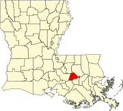
Ascension Parish is a parish located in the U.S. state of Louisiana. As of the 2020 census, the population was 126,500. Its parish seat is Donaldsonville. The parish was created in 1807. Ascension Parish is part of the Baton Rouge metropolitan statistical area.

<span class="mw-page-title-main">Fairfax, Iowa</span> City in Iowa, United States

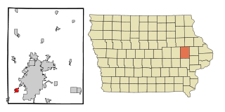
Fairfax is a city in Linn County, Iowa, United States. The population was 2,828 at the time of the 2020 census. It is part of the Cedar Rapids Metropolitan Statistical Area.

<span class="mw-page-title-main">Crowley, Louisiana</span> City in Louisiana, United States

Crowley is a city in, and the parish seat of, Acadia Parish in the U.S. state of Louisiana. At the 2020 United States census, Crowley had a population of 11,710. Crowley is the principal city of the Crowley micropolitan statistical area, which includes all of Acadia Parish. It is also part of the larger Lafayette–Acadiana combined statistical area.

<span class="mw-page-title-main">Bunkie, Louisiana</span> City in Louisiana, United States

Bunkie is a city in Avoyelles Parish, Louisiana, United States. The population was 4,171 at the 2010 census.

<span class="mw-page-title-main">Hessmer, Louisiana</span> Village in Louisiana, United States

Hessmer is a village in Avoyelles Parish, Louisiana, United States. The population was 802 at the 2010 census.

<span class="mw-page-title-main">St. Gabriel, Louisiana</span> City in Louisiana, United States

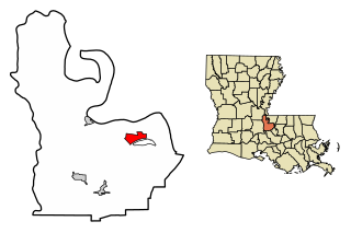
St. Gabriel is a city in Iberville Parish, Louisiana, United States. The city of St. Gabriel includes the areas of Sunshine and Carville. Part of the Baton Rouge metropolitan statistical area, it had a population of 6,677 at the 2010 U.S. census, and 6,433 at the 2020 census.

<span class="mw-page-title-main">Westwego, Louisiana</span> City in Louisiana, United States

Westwego is a city in the U.S. state of Louisiana, located in Jefferson Parish. It is a suburban community of New Orleans in the Greater New Orleans metropolitan area and lies along the west bank of the Mississippi River. The population of the city of Westwego was 8,568 at the 2020 United States census.

<span class="mw-page-title-main">Scott, Louisiana</span> City in Louisiana, United States

Scott is the fourth largest municipality in Lafayette Parish, Louisiana, United States. The population 8,614 as of the 2010 U.S. census, and 8,119 at the 2020 census, up from 7,870 at the 2000 census. Scott is a suburban community of Lafayette and is part of the Lafayette metropolitan statistical area in Acadiana.

<span class="mw-page-title-main">Robeline, Louisiana</span> Village

Robeline is a village in western Natchitoches Parish, Louisiana, United States. The population was 183 at the 2000 census. It is part of the Natchitoches Micropolitan Statistical Area.

<span class="mw-page-title-main">New Roads, Louisiana</span> City in Louisiana, United States

New Roads is a small town in Pointe Coupee Parish, Louisiana, United States. The center of population of Louisiana was located in New Roads in 2000. The population was 4,831 at the 2010 census, down from 4,966 in 2000. In the 2020 census the population was 4,549, while at the beginning year of 2023 the census showed a population of 4,205 and expects to be under 4,000 by the years end. The city's ZIP code is 70760. It is part of the Baton Rouge Metropolitan Statistical Area.

<span class="mw-page-title-main">Zwolle, Louisiana</span> Town in Louisiana, United States

Zwolle is a small town in Sabine Parish, Louisiana, United States. The population was 1,759 at the 2010 census, down from 1,783 in 2000. It was named after Zwolle, a Dutch city in Overijssel.

Luling is a census-designated place (CDP) in St. Charles Parish, Louisiana. The population was 11,512 at the 2000 census and 12,119 at the 2010 census. At the 2020 census, 13,716 people lived in Luling. It is located on the west bank of the Mississippi River. Luling is part of the New Orleans—Metairie—Kenner metropolitan statistical area.

<span class="mw-page-title-main">Amite City, Louisiana</span> Town in Louisiana, United States

Amite City is a town in and the seat of Tangipahoa Parish in southeastern Louisiana, United States. The population was 4,141 at the 2010 census. It is part of the Hammond Micropolitan Statistical Area.

<span class="mw-page-title-main">Ponchatoula, Louisiana</span> City in Louisiana

Ponchatoula is the second-largest city in Tangipahoa Parish, Louisiana. The population was 6,559 at the 2010 census and 7,545 at the time of the 2020 population estimates program.

<span class="mw-page-title-main">Rosepine, Louisiana</span> Town in Louisiana, United States

Rosepine is a town in Vernon Parish, Louisiana, United States. The population was 1,692 at the 2010 census. It is part of the Fort Polk South Micropolitan Statistical Area.

<span class="mw-page-title-main">Atlanta, Louisiana</span> Village in Louisiana, United States

Atlanta is a village in Winn Parish, Louisiana, United States. The population was 163 at the 2010 census, and had been 150 in 2000.

<span class="mw-page-title-main">Duson, Louisiana</span> Town in Louisiana, United States

Duson is a town in Acadia and Lafayette parishes in the U.S. state of Louisiana. The town was named after Curley Duson, a sheriff of St. Landry Parish. At the 2010 U.S. census, the town had a population of 1,716; in 2020, at the population estimates program, its population was 1,761. The Lafayette Parish portion of Duson is part of the Lafayette metropolitan statistical area, while the Acadia Parish portion is part of the Crowley micropolitan statistical area.

<span class="mw-page-title-main">Eunice, Louisiana</span> City in Louisiana, United States

Eunice is a city in Acadia and St. Landry parishes in the U.S. state of Louisiana. The 2010 census placed the population at 10,398, a decrease of 1,101, or 9.5 percent, from the 2000 tabulation of 11,499.

References

  1. "2020 U.S. Gazetteer Files". United States Census Bureau. Retrieved March 20, 2022.
  2. "Geographic Identifiers: 2020 Demographic Profile Data (G001): Gonzales city, Louisiana". U.S. Census Bureau, American Factfinder. Archived from the original on February 12, 2020. Retrieved May 15, 2013.
  3. "Jambalaya Festival". Jambalaya Festival Association. Retrieved January 22, 2013.
  4. Cazorla, Frank (2019) The governor Louis de Unzaga (1717-1793) Pioneer in the Birth of the United States of America and in Liberalism. Foundation Malaga, pages 48-56, 64-72, 83
  5. Leeper, Clare D'Artois (October 19, 2012). Louisiana Place Names: Popular, Unusual, and Forgotten Stories of Towns ... - Clare D'Artois Leeper - Google Books. LSU Press. ISBN   9780807147405 . Retrieved February 15, 2014.
  6. "US Gazetteer files: 2010, 2000, and 1990". United States Census Bureau. February 12, 2011. Retrieved April 23, 2011.
  7. "Geographic Identifiers: 2010 Demographic Profile Data (G001): Gonzales city, Louisiana". U.S. Census Bureau, American Factfinder. Archived from the original on February 12, 2020. Retrieved May 15, 2013.
  8. "Census of Population and Housing". Census.gov. Retrieved June 4, 2015.
  9. 1 2 "Explore Census Data". data.census.gov. Retrieved December 28, 2021.
  10. "U.S. Census website". United States Census Bureau . Retrieved January 31, 2008.
  11. "Census release shows America is more diverse and more multiracial than ever | CNN Politics". CNN. August 12, 2021. Retrieved January 17, 2023.
  12. "America is becoming more urban, more diverse and less white, 2020 Census reveals". PBS NewsHour. August 12, 2021. Retrieved January 17, 2023.
  13. "2021 ACS Income Estimates". data.census.gov. Retrieved January 17, 2023.
  14. "Edward J. Price". house.louisiana.gov. Archived from the original on April 19, 2015. Retrieved April 21, 2015.
  15. "Randal L. Gaines". intelius.com. Retrieved May 4, 2015.