
Ottawa is the capital city of Canada. It stands on the south bank of the Ottawa River in the eastern portion of southern Ontario. Ottawa borders Gatineau, Quebec, and forms the core of the Ottawa–Gatineau census metropolitan area (CMA) and the National Capital Region (NCR). As of 2016, Ottawa had a city population of 934,243 and a metropolitan population of 1,476,008 making it the fourth-largest city and the fifth-largest CMA in Canada. In June 2019, the City of Ottawa estimated it had surpassed a population of one million.

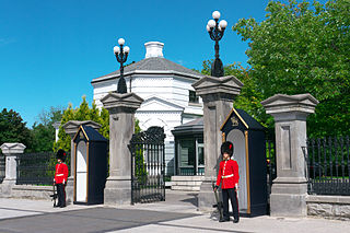
Rideau Hall is the official residence in Ottawa of both the Canadian monarch and their representative, the Governor General of Canada. It stands in Canada's capital on a 0.36-square-kilometre (88-acre) estate at 1 Sussex Drive, with the main building consisting of approximately 175 rooms across 9,500 square metres (102,000 sq ft), and 27 outbuildings around the grounds. Rideau Hall's site lies outside the centre of Ottawa. It is one of two official royal residences maintained by the federal Crown, the other being the Citadelle of Quebec.
Bytown is the former name of Ottawa, Ontario, Canada. It was founded on September 26, 1826, incorporated as a town on January 1, 1850, and superseded by the incorporation of the City of Ottawa on January 1, 1855. The founding was marked by a sod turning, and a letter from Governor General Dalhousie which authorized Lieutenant Colonel John By to divide up the town into lots. Bytown came about as a result of the construction of the Rideau Canal and grew largely due to the Ottawa River timber trade. Bytown's first mayor was John Scott, elected in 1847.

Sussex Drive, also known as Ottawa Regional Road 93, is an arterial road in Ottawa, Ontario, the capital of Canada. It is one of the city's main ceremonial and institutional routes. Travelling roughly parallel to the Ottawa River, Sussex Drive begins as a continuation of Sir George-Étienne Cartier Parkway at Rideau Gate, at the entrance to Rideau Hall. It travels south to Rideau Street, with the portion south of St. Patrick Street forming the northbound half of a one-way pair with Mackenzie Avenue. Both Mackenzie Avenue and Sussex Drive connect with Colonel By Drive at their southern end, which continues south alongside the Rideau Canal.
New Edinburgh is a neighbourhood in Rideau-Rockcliffe Ward, in Ottawa, Ontario, Canada. It is located to the northeast of the downtown core. It is bordered on the west by the Rideau River, to the north by the Ottawa River, to the south by Beechwood Avenue, and on the east by Springfield Road and the former Rockcliffe Park village limits.

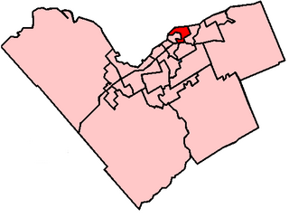
Ottawa—Vanier is a federal electoral district in Ontario, Canada, that has been represented in the House of Commons of Canada since 1935. Previous to that date, it was part of the Ottawa electoral district that returned two members.
Thomas McKay was a Canadian businessman who was one of the founders of the city of Ottawa, Ontario.

The Embassy of France in Ottawa is the diplomatic mission of France to Canada, located at 42 Sussex Drive in the New Edinburgh neighbourhood of Ottawa.

Lindenlea is a neighbourhood in Rideau-Rockcliffe Ward in Ottawa, Ontario, Canada, northeast of Downtown. It is bordered by Maple Lane to the north, Acacia Avenue to the east, Beechwood Avenue to the south and Springfield Road to the west.
Ottawa—Vanier is a provincial electoral district in Ottawa, Ontario, Canada, that has been represented in the Legislative Assembly of Ontario since 1908. It is located in the east end of Ottawa.
On May 29, 1929, a series of explosions in the sewers of Ottawa, Ontario, Canada, killed one person.
Rideau-Rockcliffe Ward is a city ward in Ottawa, Ontario. Located in the city's east end, the ward covers the neighbourhoods of New Edinburgh, Manor Park, Rockcliffe Park, Wateridge Village, Overbrook, Lindenlea, Viscount Alexander Park, Carson Meadows, Cardinal Glen, Rockcliffe Mews, Forbes, Castle Heights and part of Carson Grove.
This is a timeline of the history of Ottawa.

This is the outline of the geography of the city of Ottawa, the capital of Canada. Ottawa's current borders were formed in 2001, when the former city of Ottawa amalgamated with the ten other municipalities within the former Regional Municipality of Ottawa–Carleton. Ottawa is now a single-tiered census division, home to 870,250 people.

The Capital Pathway, also known informally as the Bike Path, is a 220-kilometre (140 mi) recreational pathway interlinking many parks, waterways and sites in Ottawa, Ontario and Gatineau, Quebec. Most of the pathway is paved, and allows an almost continuous route through the National Capital Region.
The history of Ottawa, capital of Canada, was shaped by events such as the construction of the Rideau Canal, the lumber industry, the choice of Ottawa as the location of Canada's capital, as well as American and European influences and interactions. By 1914, Ottawa's population had surpassed 100,000 and today it is the capital of a G7 country whose metropolitan population exceeds one million.
Ottawa Electric Railway Company was a streetcar public transit system in the city of Ottawa, Canada, part of the electric railway streetcars that operated between 1891 and 1959. Ottawa once had tracks through downtown on Rideau Street, Sparks Street and others, and extended outside of the downtown core to provide services that helped form communities such as Westboro, Old Ottawa South and The Glebe. Prior to this, starting in 1866, public transportation was provided by Ottawa City Passenger Railway Company, a horse-drawn tram service. The O.E.R. was taken over by the Ottawa Transportation Commission in 1948, which was itself succeeded by OC Transpo in 1973.

Sawmill Creek is a creek located in Ottawa, Ontario, Canada. It is a tributary of the Rideau River. It rises in the wetlands south and southwest of the community of Blossom Park in the Ottawa Greenbelt, specifically south of Lester Road. It flows roughly north by northwest through Blossom Park, and the neighbourhood of South Keys, through the McCarthy Woods, and then separates the neighbourhood of Riverside Park on the west from the neighbourhoods of Ellwood and Heron Park on the east, before entering the Rideau River at Billings Bridge, near the intersection of Bank Street and Riverside Drive.

McKay Lake is a meromictic lake located in the former Village of Rockcliffe Park in Ottawa, Ontario, Canada.

