New Edinburgh

Last updated

New Edinburgh
Neighbourhood
10 Rideau Hall P1350154.jpg
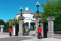
Main gate of Rideau Hall
Newottawamap.png
Red pog.svg
New Edinburgh
Location in Ottawa
Coordinates: 45°26′40″N75°41′30″W / 45.44444°N 75.69167°W / 45.44444; -75.69167
CountryCanada
Province Ontario
City Ottawa
Established1829
Incorporated 1867 (Village of New Edinburgh)
Annexation 1887 (City of Ottawa)
Government
   MPs Mona Fortier
   MPPs Lucille Collard
   Councillors Rawlson King
Elevation
60 m (200 ft)
Population
 (2016)
  Total3,539
  Canada 2016 Census
Time zone UTC-5 (Eastern (EST))
Forward sortation area
K1M

New Edinburgh is a neighbourhood in Rideau-Rockcliffe Ward, in Ottawa, Ontario, Canada. It is located to the northeast of the downtown core. It is bordered on the west by the Rideau River, to the north by the Ottawa River, to the south by Beechwood Avenue, and on the east by Springfield Road and the former Rockcliffe Park village limits. [1]

Contents

The area is an older, affluent neighbourhood. The Governor General of Canada's large residence and grounds are located in New Edinburgh, as is 24 Sussex Drive, official residence of the Prime Minister of Canada.

The neighbourhood is home to several embassies and consulates, including those of Spain, South Africa, France, India, Vietnam, and Slovakia. Civil servants (in particular, employees of the nearby Global Affairs Canada) compose a fair portion of the population. Like Rockcliffe Park, the neighbourhood is largely English-speaking, in comparison to the French-speaking district of Vanier to the south.

The total population of New Edinburgh is 3,539 (2016 Census). [2]

History

The Frasier Schoolhouse, built in 1837, is one of the few buildings left from the village's early history. Frasier School.JPG
The Frasier Schoolhouse, built in 1837, is one of the few buildings left from the village's early history.

New Edinburgh was founded by Thomas McKay, one of the builders of the Rideau Canal lock system. He bought the land at the junction of the Ottawa and Rideau Rivers in 1829 and created a village named for Edinburgh in his native Scotland. Often pronounced as rhyming with "Pittsburgh", the traditional pronunciation would be 'New Edinburrah' owing to McKay's Scottish heritage. The streets in the neighbourhood were named after McKay's family. Crichton was his wife's maiden name, Keefer his son in law, while Thomas, John, and Charles were his sons. The area was originally largely industrial, home to a number of mills using the power of the river. Originally part of Gloucester Township, New Edinburgh was incorporated as a separate village in 1866 by a special act of parliament, but was annexed in 1887 by Ottawa.

In August 2000, The School of Dance moved into its building in New Edinburgh where the old Crichton Street School was situated.

New Edinburgh has their own local community newspaper, New Edinburgh News, assisted by many of the locals.

Churches

Parks

See also

Related Research Articles

<span class="mw-page-title-main">Sandy Hill, Ottawa</span> Neighbourhood in Ottawa, Ontario, Canada

Sandy Hill is a neighbourhood in Ottawa, Ontario, located just east of downtown. The neighbourhood is bordered on the west by the Rideau Canal, and on the east by the Rideau River. To the north it stretches to Rideau Street and the Byward Market area while to the south it is bordered by the Queensway highway and Nicholas Street. The area is named for its hilliness, caused by the river, and its sandy soil, which makes it difficult to erect large buildings. It is home to a number of embassies, residences and parks. Le Cordon Bleu operates its Canadian school there, at the opposite end of Sandy Hill from the University of Ottawa.

<span class="mw-page-title-main">Rockcliffe Park</span> Neighbourhood in Ottawa, Ontario, Canada

Rockcliffe Park is a neighbourhood in Rideau-Rockcliffe Ward, close to the centre of Ottawa, Ontario, Canada. Established in 1864, organized as a Police village in 1908, and an independent village from 1926, and ultimately amalgamated with the rest of Ottawa on January 1, 2001. As of 2011, it had a population of 2,021. In 1977 the entire village of Rockcliffe Park was designated a Heritage Conservation District. Rockcliffe Park is one of only a handful of surviving nineteenth-century communities of its kind in North America.

Riverview is a neighbourhood in Ottawa, Ontario, Canada. It is southeast of the downtown adjacent to the Rideau River, its location on which is its namesake. The 2021 Census population of Riverview is 13,113.

<span class="mw-page-title-main">Vanier, Ontario</span> Neighbourhood in Ottawa, Ontario, Canada

Vanier, formerly Eastview, is a neighbourhood in the Rideau-Vanier Ward of the east end of Ottawa, Ontario, Canada. Historically francophone and working class, the neighbourhood was a separate city until being amalgamated into Ottawa in 2001. It no longer has a majority francophone population. By 2012 its francophone population had shrunk to less than 40% from 63% in the early 1980s. The neighbourhood is located on the east bank of the Rideau River, across from the neighbourhoods of Lowertown and Sandy Hill, and just south of Rockcliffe Park, New Edinburgh, Lindenlea, and Manor Park. To the east of Vanier are the suburbs of Gloucester. Vanier has a relatively small area with a high population density.

<span class="mw-page-title-main">Sussex Drive</span> Ceremonial road in Ottawa

Sussex Drive, also known as Ottawa Regional Road 93, is an arterial road in Ottawa, Ontario, the capital of Canada. It is one of the city's main ceremonial and institutional routes. Travelling roughly parallel to the Ottawa River, Sussex Drive begins as a continuation of Sir George-Étienne Cartier Parkway at Rideau Gate, at the entrance to Rideau Hall. It travels south to Rideau Street, with the portion south of St. Patrick Street forming the northbound half of a one-way pair with Mackenzie Avenue. Both Mackenzie Avenue and Sussex Drive connect with Colonel By Drive at their southern end, which continues south alongside the Rideau Canal.

<span class="mw-page-title-main">Ottawa—Vanier (federal electoral district)</span> Federal electoral district in Ontario, Canada

Ottawa—Vanier is a federal electoral district in Ontario, Canada, that has been represented in the House of Commons of Canada since 1935. Previous to that date, it was part of the Ottawa electoral district that returned two members.

<span class="mw-page-title-main">Downtown Ottawa</span> Neighbourhood in Ottawa, Ontario, Canada

Downtown Ottawa is the central area of Ottawa, Ontario, Canada. It is sometimes referred to as the Central Business District and contains Ottawa's financial district. It is bordered by the Ottawa River to the north, the Rideau Canal to the east, Gloucester Street to the south and Bronson Avenue to the west. This area and the residential neighbourhood to the south are also known locally as 'Centretown'. The total population of the area is 5,501.

<span class="mw-page-title-main">St. Bartholomew's Anglican Church (Ottawa)</span> Church in Ottawa, Ontario

St. Bartholomew's Anglican Church is a place of worship in Ottawa, Ontario, Canada. The building was constructed in the latter half of the 19th century and serves the surrounding neighbourhoods. Additionally, St. Bartholomew's is, due to its location next to Rideau Hall, the place of worship for various Governors General of Canada and some members of the Canadian Royal Family. It is also the regimental chapel of the Governor General's Foot Guards.

Thomas McKay was a Canadian businessman who was one of the founders of the city of Ottawa, Ontario.

<span class="mw-page-title-main">Carleton (Ontario federal electoral district)</span> Federal electoral district in Ontario, Canada

Carleton is a federal electoral district in Ontario, Canada, represented in the House of Commons of Canada from 1867 to 1968 and since 2015. It was represented in the Legislative Assembly of Upper Canada from 1821 to 1840 and in the Legislative Assembly of the Province of Canada from 1841 until 1866. It has been represented by Pierre Poilievre, the current Leader of the Opposition, since its creation in 2015.

<span class="mw-page-title-main">Russell (Ontario federal electoral district)</span> Former federal electoral district in Ontario, Canada

Russell was a federal electoral district in eastern Ontario, Canada, that was represented in the House of Commons of Canada from 1867 to 1968.

<span class="mw-page-title-main">Alta Vista, Ottawa</span> Neighbourhood in Ottawa, Ontario, Canada

Alta Vista is a neighbourhood in Alta Vista Ward in Ottawa, Ontario, Canada. Its boundaries according to the Alta Vista Community Association are that part of Alta Vista Ward south of Smyth Road in the north, north of Walkley Road and east of the Rideau River, and west of the "greenspace underneath Haig Drive". However, the name is ambiguous, as there are several sub-neighbourhoods in this area,, as the neighbourhood could refer to the ward as a whole, down to the core Alta Vista area,, centred on Alta Vista Drive.

<span class="mw-page-title-main">Manor Park, Ottawa</span> Neighbourhood in Ottawa, Ontario, Canada

Manor Park is a neighbourhood in Rideau-Rockcliffe Ward in the east end of Ottawa, Ontario, Canada on the east side of Rockcliffe Park.

Overbrook is an urban neighbourhood situated in Rideau-Rockcliffe Ward, in the east end of Ottawa, Ontario, Canada. It is located across the Rideau River from the neighbourhood of Sandy Hill and is just to the south of Vanier. To the east of Overbrook is the former City of Gloucester. It was constituted as a police village in 1922 and was annexed by the City of Ottawa in 1950.

<span class="mw-page-title-main">Ottawa—Vanier (provincial electoral district)</span> Provincial electoral district in Ontario, Canada

Ottawa—Vanier is a provincial electoral district in Ottawa, Ontario, Canada, that has been represented in the Legislative Assembly of Ontario since 1908. It is located in the east end of Ottawa.

<span class="mw-page-title-main">Rideau-Rockcliffe Ward</span> Place in Ontario, Canada

Rideau-Rockcliffe Ward is a city ward in Ottawa, Ontario. Located in the city's east end, the ward covers the neighbourhoods of New Edinburgh, Manor Park, Rockcliffe Park, Wateridge Village, Overbrook, Lindenlea, Viscount Alexander Park, Carson Meadows, Cardinal Glen, Rockcliffe Mews, Forbes, Castle Heights and part of Carson Grove.

<span class="mw-page-title-main">Centretown</span> Neighbourhood in Ottawa, Ontario, Canada

Centretown is a neighbourhood in Somerset Ward, in central Ottawa, Ontario, Canada. It is defined by the city as "the area bounded on the north by Gloucester Street and Lisgar Street, on the east by the Rideau Canal, on the south by the Queensway freeway and on the west by Bronson Avenue." Traditionally it was all of Ottawa west of the Rideau Canal, while Lower Town was everything to the east. For certain purposes, such as the census and real estate listings, the Golden Triangle and/or Downtown Ottawa is included in Centretown and it is considered part of Centretown by the Centretown Citizens Community Association as well as being used in this way in casual conversation.

The following outline is provided as an overview of and topical guide to Ottawa:

<span class="mw-page-title-main">Governor Bay</span> Bay in Ontario, Canada

Governor Bay, better known historically as Governor's Bay is a bay in the Ottawa River in Ottawa, Ontario, Canada. It is roughly located between the neighbourhoods of New Edinburgh and Rockcliffe Park, below 24 Sussex, the official residence of the Prime Minister of Canada, and adjacent to Rideau Hall, the home of the Governor General of Canada.

References

  1. "About Us – New Edinburgh".
  2. Population calculated by combining Dissemination Areas 35060221, 35060243, 35060220, 35060219, 35061346, 35061345, 35061344 with Census Blocks 35061343006 and 35061347001.
Bibliography