Grafton, Iowa

Last updated
Grafton, Iowa
Worth County Iowa Incorporated and Unincorporated areas Grafton Highlighted.svg
Location of Grafton, Iowa
Coordinates: 43°19′46″N93°4′13″W / 43.32944°N 93.07028°W / 43.32944; -93.07028 Coordinates: 43°19′46″N93°4′13″W / 43.32944°N 93.07028°W / 43.32944; -93.07028
Country Flag of the United States.svg  United States
State Flag of Iowa.svg  Iowa
County Worth
Area
[1]
  Total0.32 sq mi (0.83 km2)
  Land0.32 sq mi (0.83 km2)
  Water0.00 sq mi (0.00 km2)
Elevation
1,230 ft (375 m)
Population
 (2020)
  Total216
  Density672.90/sq mi (260.05/km2)
Time zone UTC-6 (Central (CST))
  Summer (DST) UTC-5 (CDT)
ZIP code
50440
Area code 641
FIPS code 19-31890
GNIS feature ID0457012

Grafton is a city in Worth County, Iowa, United States. The population was 216 in the 2020 census, a decrease of 13.1% from the 290 population in the 2000 census. [2] It is part of the Mason City Micropolitan Statistical Area.

Contents

Post card of Lutheran Church in Grafton, IA Circa 1910 Lutheran Church Grafton ,IA.jpg
Post card of Lutheran Church in Grafton, IA Circa 1910

History

The Grafton Iowa Depot building Grafton Iowa Depot.jpg
The Grafton Iowa Depot building

Grafton got its start in the year 1878, following construction of the Chicago, Milwaukee and St. Paul Railway through that territory. [3]

Geography

Grafton is located at 43°19′46″N93°4′13″W / 43.32944°N 93.07028°W / 43.32944; -93.07028 (43.329394, -93.070164). [4]

According to the United States Census Bureau, the city has a total area of 0.33 square miles (0.85 km2), all land. [5]

Public School in Grafton, IA pre 1910 School Grafton, IA.jpg
Public School in Grafton, IA pre 1910

Demographics

Historical population
CensusPop.Note
1900 156
1910 18317.3%
1920 23327.3%
1930 2496.9%
1940 37−85.1%
1950 4418.9%
1960 476.8%
1970 254440.4%
1980 2550.4%
1990 28210.6%
2000 2902.8%
2010 252−13.1%
2020 216−14.3%
U.S. Decennial Census [6] [2]
The population of Grafton, Iowa from US census data GraftonIowaPopPlot.png
The population of Grafton, Iowa from US census data

2010 census

As of the census [7] of 2010, there were 252 people, 114 households, and 70 families residing in the city. The population density was 763.6 inhabitants per square mile (294.8/km2). There were 126 housing units at an average density of 381.8 per square mile (147.4/km2). The racial makeup of the city was 98.8% White, 0.4% Asian, and 0.8% from two or more races.

There were 114 households, of which 26.3% had children under the age of 18 living with them, 52.6% were married couples living together, 6.1% had a female householder with no husband present, 2.6% had a male householder with no wife present, and 38.6% were non-families. 34.2% of all households were made up of individuals, and 15.8% had someone living alone who was 65 years of age or older. The average household size was 2.21 and the average family size was 2.84.

The median age in the city was 43.5 years. 22.2% of residents were under the age of 18; 7.2% were between the ages of 18 and 24; 22.3% were from 25 to 44; 29.7% were from 45 to 64; and 18.7% were 65 years of age or older. The gender makeup of the city was 51.2% male and 48.8% female.

2000 census

As of the census [8] of 2000, there were 290 people, 119 households, and 82 families residing in the city. The population density was 895.8 inhabitants per square mile (345.9/km2). There were 132 housing units at an average density of 407.7 per square mile (157.4/km2). The racial makeup of the city was 98.97% White, 0.34% Asian, and 0.69% from two or more races.

There were 119 households, out of which 35.3% had children under the age of 18 living with them, 52.9% were married couples living together, 8.4% had a female householder with no husband present, and 30.3% were non-families. 27.7% of all households were made up of individuals, and 14.3% had someone living alone who was 65 years of age or older. The average household size was 2.44 and the average family size was 2.92.[ citation needed ]

In the city, the population was spread out, with 29.3% under the age of 18, 5.5% from 18 to 24, 30.7% from 25 to 44, 14.8% from 45 to 64, and 19.7% who were 65 years of age or older. The median age was 37 years. For every 100 females, there were 108.6 males. For every 100 females age 18 and over, there were 107.1 males.

The median income for a household in the city was $28,594, and the median income for a family was $34,063. Males had a median income of $28,906 versus $22,500 for females. The per capita income for the city was $14,201. About 2.4% of families and 5.8% of the population were below the poverty line, including 8.9% of those under the age of eighteen and 6.2% of those 65 or over.

Education

It is within the St. Ansgar Community School District school district. [9]

Related Research Articles

<span class="mw-page-title-main">Worth County, Iowa</span> County in Iowa, United States

Worth County is a county located in the U.S. state of Iowa. As of the 2020 census, the population was 7,443. The county seat is Northwood. The county was founded in 1851 and named for Major General William Jenkins Worth (1794–1849), an officer in both the Seminole War and the Mexican–American War.

<span class="mw-page-title-main">Beaver, Iowa</span> City in Iowa, United States

Beaver is a city in Amaqua Township, Boone County, Iowa, United States. The population was 46 at the 2020 census. It is part of the 'Boone, Iowa Micropolitan Statistical Area', which is a part of the larger Ames-Boone, Iowa Combined Statistical Area.

<span class="mw-page-title-main">Bristow, Iowa</span> City in Iowa, United States

Bristow is a city in Butler County, Iowa, United States. The population was 145 at the 2020 census.

<span class="mw-page-title-main">Yetter, Iowa</span> City in Iowa, United States

Yetter is a city in Calhoun County, Iowa, United States. The population was 19 at the time of the 2020 census.

<span class="mw-page-title-main">Ventura, Iowa</span> City in Iowa, United States

Ventura is a city in Cerro Gordo County, Iowa, United States. The population was 711 at the time of the 2020 census. It is part of the Mason City Micropolitan Statistical Area. Ventura is located on the northeastern basin of Clear Lake, making it an area with many lakeside areas.

<span class="mw-page-title-main">Alta Vista, Iowa</span> City in Iowa, United States

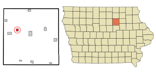
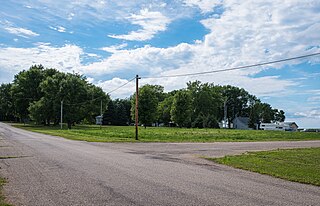
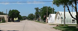
Alta Vista is a city in Chickasaw County, Iowa, United States. The population was 227 at the 2020 census.

<span class="mw-page-title-main">St. Olaf, Iowa</span> City in Iowa, United States

St. Olaf is a city in Clayton County, Iowa, United States. The population was 106 at the time of the 2020 census, down from 136 in 2000. Swiss Valley has a large cheese packaging plant in St. Olaf.

<span class="mw-page-title-main">St. Lucas, Iowa</span> City in Iowa, United States

St. Lucas is a city in Fayette County, Iowa, United States. The population was 167 at the time of the 2020 census.

<span class="mw-page-title-main">Waucoma, Iowa</span> City in Iowa, United States

Waucoma is a city in Fayette County, Iowa, United States. The population was 229 at the time of the 2020 census.

<span class="mw-page-title-main">Rudd, Iowa</span> City in Iowa, United States

Rudd is a city in Floyd County, Iowa, United States. The population was 358 at the time of the 2020 census, a decline of 16.9% from 431 in 2000.

<span class="mw-page-title-main">Delta, Iowa</span> City in Iowa, United States

Delta is a city in Keokuk County, Iowa, United States. The population was 264 at the 2020 census.

<span class="mw-page-title-main">Mitchell, Iowa</span> City in Iowa, United States

Mitchell is a city in Mitchell County, Iowa, United States. The population was 124 at the time of the 2020 census.

<span class="mw-page-title-main">Donahue, Iowa</span> City in Iowa, United States

Donahue is a city in Scott County, Iowa, United States. The population was 335 at the 2020 census. The city has a mayor-council form of government.

<span class="mw-page-title-main">Matlock, Iowa</span> City in Iowa, United States

Matlock is a city in Sioux County, Iowa, United States. The population was 74 at the time of the 2020 census.

<span class="mw-page-title-main">Ridgeway, Iowa</span> City in Iowa, United States

Ridgeway is a city in Winneshiek County, Iowa, United States. The population was 275 at the time of the 2020 census.

<span class="mw-page-title-main">Belview, Minnesota</span> City in Minnesota, United States

Belview is a city in Redwood County, Minnesota, United States. The population was 384 at the 2010 census.

<span class="mw-page-title-main">Grafton, Nebraska</span> Village in Nebraska, United States

Grafton is a village in Fillmore County, Nebraska, United States. The population was 107 at the 2020 census.

<span class="mw-page-title-main">Hankinson, North Dakota</span> City in North Dakota, United States

Hankinson is a city in Richland County, North Dakota, United States. The population was 921 at the 2020 census. Hankinson was founded in 1886. It is part of the Wahpeton, ND–MN Micropolitan Statistical Area.

<span class="mw-page-title-main">Conemaugh Township, Cambria County, Pennsylvania</span> Township in Pennsylvania, United States

Conemaugh Township is a township in Cambria County, Pennsylvania, United States. The population was 1,943 at the 2020 census. It is part of the Johnstown, Pennsylvania Metropolitan Statistical Area.

<span class="mw-page-title-main">Clearfield, Iowa</span> City in Iowa, United States

Clearfield is a city in Taylor and Ringgold counties in the U.S. state of Iowa. The population was 278 at the time of the 2020 census.

References

  1. "2020 U.S. Gazetteer Files". United States Census Bureau. Retrieved March 16, 2022.
  2. 1 2 "2020 Census State Redistricting Data". census.gov. United states Census Bureau. Retrieved 12 August 2021.
  3. Clyde, Jefferson F. (1918). History of Mitchell and Worth Counties, Iowa, Volume 1. S.J. Clarke Publishing Company. p. 356.
  4. "US Gazetteer files: 2010, 2000, and 1990". United States Census Bureau. 2011-02-12. Retrieved 2011-04-23.
  5. "US Gazetteer files 2010". United States Census Bureau. Archived from the original on 2012-01-25. Retrieved 2012-05-11.
  6. "Census of Population and Housing". Census.gov. Retrieved June 4, 2015.
  7. "U.S. Census website". United States Census Bureau . Retrieved 2012-05-11.
  8. "U.S. Census website". United States Census Bureau . Retrieved 2008-01-31.
  9. "St Ansgar" (PDF). Iowa Department of Education . Retrieved 2020-04-07.