Northwood, Iowa | |
---|---|
Coordinates: 43°26′45″N93°13′9″W / 43.44583°N 93.21917°W Coordinates: 43°26′45″N93°13′9″W / 43.44583°N 93.21917°W | |
Country | United States |
State | Iowa |
County | Worth |
Area | |
• Total | 3.99 sq mi (10.32 km2) |
• Land | 3.99 sq mi (10.32 km2) |
• Water | 0.00 sq mi (0.00 km2) |
Elevation | 1,230 ft (375 m) |
Population (2020) | |
• Total | 2,072 |
• Density | 519.82/sq mi (200.72/km2) |
Time zone | UTC-6 (Central (CST)) |
• Summer (DST) | UTC-5 (CDT) |
ZIP code | 50459 |
Area code | 641 |
FIPS code | 19-57630 |
GNIS feature ID | 0459654 |
Website | www |
Northwood is a city in Worth County, Iowa, United States, along the Shell Rock River. The population was 2,072 at the time of the 2020 census. [2] It is the county seat of Worth County. [3]
Northwood is part of the Mason City Micropolitan Statistical Area.
Northwood's longitude and latitude coordinates
in decimal form are 43.445783, -93.219123. [6]
According to the United States Census Bureau, the city has a total area of 3.76 square miles (9.74 km2), all land. [7]
Year | Pop. | ±% |
---|---|---|
1870 | 289 | — |
1880 | 844 | +192.0% |
1890 | 859 | +1.8% |
1900 | 1,271 | +48.0% |
1910 | 1,264 | −0.6% |
1920 | 1,597 | +26.3% |
1930 | 1,554 | −2.7% |
1940 | 1,724 | +10.9% |
1950 | 1,767 | +2.5% |
1960 | 1,768 | +0.1% |
1970 | 1,950 | +10.3% |
1980 | 2,193 | +12.5% |
1990 | 1,940 | −11.5% |
2000 | 2,050 | +5.7% |
2010 | 1,989 | −3.0% |
2020 | 2,072 | +4.2% |
Source: "U.S. Census website". United States Census Bureau . Retrieved 2020-03-29. Source: |
As of the census [9] of 2010, there were 1,989 people, 885 households, and 530 families living in the city. The population density was 529.0 inhabitants per square mile (204.2/km2). There were 1,004 housing units at an average density of 267.0 per square mile (103.1/km2). The racial makeup of the city was 97.3% White, 0.5% African American, 0.2% Native American, 0.1% Asian, 0.9% from other races, and 1.1% from two or more races. Hispanic or Latino of any race were 2.3% of the population.
There were 885 households, of which 25.3% had children under the age of 18 living with them, 47.5% were married couples living together, 9.3% had a female householder with no husband present, 3.2% had a male householder with no wife present, and 40.1% were non-families. 35.0% of all households were made up of individuals, and 17.1% had someone living alone who was 65 years of age or older. The average household size was 2.19 and the average family size was 2.80.
The median age in the city was 44.2 years. 21.8% of residents were under the age of 18; 6.7% were between the ages of 18 and 24; 22.4% were from 25 to 44; 27.2% were from 45 to 64; and 21.8% were 65 years of age or older. The gender makeup of the city was 48.1% male and 51.9% female.
As of the census [10] of 2000, there were 2,050 people, 914 households, and 549 families living in the city. The population density was 542.2 inhabitants per square mile (209.3/km2). There were 982 housing units at an average density of 259.7 per square mile (100.3/km2). The racial makeup of the city was 98.24% White, 0.10% African American, 0.10% Native American, 0.20% Asian, 0.44% from other races, and 0.93% from two or more races. Hispanic or Latino of any race were 2.39% of the population.
There were 914 households, out of which 25.8% had children under the age of 18 living with them, 47.9% were married couples living together, 8.9% had a female householder with no husband present, and 39.9% were non-families. 36.0% of all households were made up of individuals, and 20.6% had someone living alone who was 65 years of age or older. The average household size was 2.15 and the average family size was 2.76.
20.5% are under the age of 18, 7.2% from 18 to 24, 23.9% from 25 to 44, 22.4% from 45 to 64, and 26.0% who were 65 years of age or older. The median age was 44 years. For every 100 females, there were 89.5 males. For every 100 females age 18 and over, there were 84.8 males.
The median income for a household in the city was $33,030, and the median income for a family was $41,445. Males had a median income of $27,589 versus $20,637 for females. The per capita income for the city was $18,167. About 6.4% of families and 7.9% of the population were below the poverty line, including 5.8% of those under age 18 and 11.6% of those age 65 or over.
The Northwood-Kensett Community School District operates local area public schools. [11]
Humid continental climate is a climatic designation typified by large seasonal temperature differences, with warm to hot (and often humid) summers and cold (sometimes severely cold) winters. The Köppen Climate Classification subtype for this climate is "Dfb" (Hot Summer Continental Climate). [12]
Climate data for Northwood, Iowa (1991–2020 normals, extremes 1896–present) | |||||||||||||
---|---|---|---|---|---|---|---|---|---|---|---|---|---|
Month | Jan | Feb | Mar | Apr | May | Jun | Jul | Aug | Sep | Oct | Nov | Dec | Year |
Record high °F (°C) | 63 (17) | 65 (18) | 83 (28) | 93 (34) | 105 (41) | 103 (39) | 107 (42) | 103 (39) | 98 (37) | 93 (34) | 79 (26) | 66 (19) | 107 (42) |
Average high °F (°C) | 21.3 (−5.9) | 25.7 (−3.5) | 38.4 (3.6) | 54.0 (12.2) | 66.3 (19.1) | 76.0 (24.4) | 78.6 (25.9) | 76.4 (24.7) | 70.8 (21.6) | 57.1 (13.9) | 40.8 (4.9) | 27.4 (−2.6) | 52.7 (11.5) |
Daily mean °F (°C) | 12.6 (−10.8) | 16.9 (−8.4) | 29.5 (−1.4) | 43.3 (6.3) | 55.6 (13.1) | 65.9 (18.8) | 69.0 (20.6) | 66.5 (19.2) | 59.3 (15.2) | 46.1 (7.8) | 31.7 (−0.2) | 19.4 (−7.0) | 43.0 (6.1) |
Average low °F (°C) | 3.8 (−15.7) | 8.0 (−13.3) | 20.6 (−6.3) | 32.6 (0.3) | 44.9 (7.2) | 55.9 (13.3) | 59.4 (15.2) | 56.6 (13.7) | 47.9 (8.8) | 35.1 (1.7) | 22.6 (−5.2) | 11.4 (−11.4) | 33.2 (0.7) |
Record low °F (°C) | −37 (−38) | −34 (−37) | −27 (−33) | 4 (−16) | 20 (−7) | 32 (0) | 38 (3) | 35 (2) | 20 (−7) | −2 (−19) | −16 (−27) | −27 (−33) | −37 (−38) |
Average precipitation inches (mm) | 1.07 (27) | 1.02 (26) | 1.99 (51) | 3.82 (97) | 4.78 (121) | 5.13 (130) | 4.73 (120) | 3.92 (100) | 3.32 (84) | 2.68 (68) | 1.73 (44) | 1.28 (33) | 35.47 (901) |
Average snowfall inches (cm) | 10.9 (28) | 9.3 (24) | 6.2 (16) | 3.3 (8.4) | 0.0 (0.0) | 0.0 (0.0) | 0.0 (0.0) | 0.0 (0.0) | 0.0 (0.0) | 0.3 (0.76) | 2.6 (6.6) | 7.6 (19) | 40.2 (102) |
Average precipitation days (≥ 0.01 in) | 7.8 | 6.0 | 7.6 | 10.0 | 12.0 | 11.1 | 8.6 | 8.4 | 7.8 | 8.1 | 6.8 | 6.9 | 101.1 |
Average snowy days (≥ 0.1 in) | 6.2 | 4.9 | 3.4 | 1.0 | 0.0 | 0.0 | 0.0 | 0.0 | 0.0 | 0.2 | 2.3 | 5.4 | 23.4 |
Source: NOAA [13] [14] |
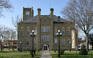
Worth County is a county located in the U.S. state of Iowa. As of the 2020 census, the population was 7,443. The county seat is Northwood. The county was founded in 1851 and named for Major General William Jenkins Worth (1794–1849), an officer in both the Seminole War and the Mexican–American War.
Kensett is a city in White County, Arkansas, United States. Located adjacent to the east side of Searcy, the city is the hometown of noted legislator Wilbur D. Mills, who was influential throughout the 1960s and 1970s in the United States House of Representatives.
Tripoli is a city in Bremer County, Iowa, United States. The population was 1,191 at the time of the 2020 census. It is part of the Waterloo–Cedar Falls Metropolitan Statistical Area.
Waukee is a city in Dallas County, Iowa, United States. The population was 23,940 at the time of the 2020 U.S. Census. It is part of the Des Moines – West Des Moines Metropolitan Statistical Area.
Grundy Center is a city in Grundy County, Iowa. The population was 2,796 at the time of the 2020 census, a 7.7% increase from 2,596 at the 2000 census. Grundy Center is also the county seat of Grundy County. Grundy Center is part of the Waterloo–Cedar Falls Metropolitan Statistical Area.
Guthrie Center is a city in Guthrie County, Iowa, United States, along the South Raccoon River. The population was 1,593 at the time of the 2020 census. It is the county seat of Guthrie County.
Britt is a city in Hancock County, Iowa, United States, and is the home of the National Hobo Convention and the Hobo Museum. The population was 2,044 at the 2020 census.
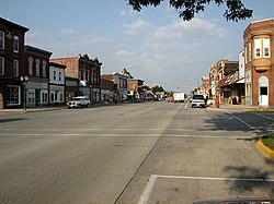
Iowa Falls is a city in Hardin County, Iowa, United States. Iowa Falls is the home of Ellsworth Community College. It is also a regional transportation center, located along U.S. Routes 20 and 65 and the Canadian National and Union Pacific Railroads. The population was 5,106 at the time of the 2020 census. A landmark in the city is its movie theater. Built as the Metropolitan Opera House in 1899, it presented plays, operas, and vaudeville in the town during the first half of the twentieth century, and today is listed on the National Register of Historic Places.
Steamboat Rock is a city in Hardin County, Iowa, United States. The population was 264 at the time of the 2020 census.
Logan is a city and county seat of Harrison County, Iowa, United States, along the Boyer River. The population was 1,397 at the time of the 2020 census.
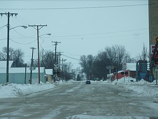
Swea City is a city in Kossuth County, Iowa, United States. The population was 566 at the time of the 2020 census.
Chariton is a city in, and the county seat of, Lucas County, Iowa, United States. The population was 4,193 at the 2020 census. Lucas is the primary distribution center for and the former corporate headquarters of the Hy-Vee supermarket chain.
Emmetsburg is a city in Palo Alto County, Iowa, United States. The population was 3,706 at the time of the 2020 census. It is the county seat of Palo Alto County. Emmetsburg is located around the southern bay of Five Island Lake.
Oakland is a city located along the West Nishnabotna River in Pottawattamie County, Iowa, United States. The population was 1,524 at the time of the 2020 census. Formerly named Big Grove, Oakland is home to Nishna Heritage Museum and a number of historical buildings.
Beaconsfield is a city in Ringgold County, Iowa, United States. The population was 15 in the 2020 census, unchanged from 2010 and an increase from 11 in 2000. In the 2000 census Beaconsfield was the least populated incorporated city in Iowa; with the increase in the 2020 census, it is now the second smallest, after with Le Roy.
Kensett is a city in Worth County, Iowa, United States. The population was 257 at the time of the 2020 census. It is part of the Mason City Micropolitan Statistical Area.
Northwoods is a city in St. Louis County, Missouri, United States. The population was 4,227 at the 2010 census.
Emerado is a city in Grand Forks County, North Dakota, United States located near Grand Forks Air Force Base. It is part of the "Grand Forks, ND-MN Metropolitan Statistical Area" or "Greater Grand Forks". The population was 443 at the 2020 census. Grand Forks Air Force Base is located near Emerado.
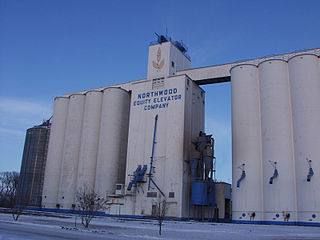
Northwood is a city in Grand Forks County, North Dakota, United States. It is part of the "Grand Forks, ND-MN Metropolitan Statistical Area" or "Greater Grand Forks." The population was 982 at the 2020 census.
Northwood is a city and eastern suburb in Wood County, Ohio, United States, within the Toledo metropolitan area. The population was 5,265 at the 2010 census.