Granville, New York

Last updated

Granville
Granville, NY, post office.jpg
Granville Post Office
Washington County New York incorporated and unincorporated areas Granville highlighted.svg
Location in Washington County and the state of New York.
Coordinates: 43°25′20″N73°18′20″W / 43.42222°N 73.30556°W / 43.42222; -73.30556
Country United States
State New York
County Washington
Government
  MayorPaul Labas
Area
[1]
  Total56.12 sq mi (145.35 km2)
  Land55.62 sq mi (144.05 km2)
  Water0.50 sq mi (1.30 km2)
Elevation
653 ft (199 m)
Population
 (2020) [2]
  Total6,215
  Density111.7/sq mi (43.1/km2)
Time zone UTC-5 (Eastern (EST))
  Summer (DST) UTC-4 (EDT)
ZIP codes [3]
12832 (primary)
Area code 518
FIPS code 36-30037
GNIS feature ID0979014

Granville is a town on the eastern border of Washington County, New York, United States, abutting Rutland County, Vermont. It is part of the Glens Falls Metropolitan Statistical Area. [4] The town population was 6,215 at the 2020 census. [2]

Contents

The town of Granville contains a village that also bears the name Granville. Granville is named for John Carteret, 2nd Earl Granville. [5]

Granville has been called the "Colored Slate Capital of the World." Quarries in the town mine slate that comes in colors such as green, gray, gray black, purple, mottled green and purple, and red. [6] Walter Granville-Smith was born in Granville.

Granville Avenue and the associated CTA station in Chicago are named after the town, [7] as was the former Town of Granville, Wisconsin.

History

From evidence discovered circa 1850, the St. Francis Native Americans appear to have used the town for hunting and making tools in the past.[ citation needed ]

Perspective map of Granville with list of landmarks from 1886 by L.R. Burleigh Granville, N.Y. LOC 75694780.tif
Perspective map of Granville with list of landmarks from 1886 by L.R. Burleigh

This border area between Vermont and New York was, for a long period, not clearly under control of either state. Arrivals from New England settled here, hoping to gain the benefits of New England in areas such as land ownership and voting rights. Early settlers arrived before 1770, but the state line was not established until 1790, leaving settlers in this town within New York State.

The town was founded in 1780.

Early agricultural efforts included dairy herds and sheep raising.

Extensive slate deposits were located in 1846 in nearby Fair Haven, and in 1850 more slate deposits were found in Middle Granville. The first Granville slate quarries opened around 1853. The first slate deposits had been located in 1839 and were used for local construction.

Geography

The eastern town line is the border of Vermont (Rutland County).

According to the United States Census Bureau, the town has a total area of 56.1 square miles (145.4 km2), of which 56.1 square miles (145.2 km2) is land and 0.04 square mile (0.1 km2) (0.05%) is water.

NY 22A diverges from NY 22 by Middle Granville. NY 149 joins NY 22 south of Granville village.

The Mettawee River and the Indian River are two large streams in the town.

Neighboring cities and towns

Demographics

Historical population
CensusPop.Note
1820 3,727
1830 3,8824.2%
1840 3,846−0.9%
1850 3,434−10.7%
1860 3,4741.2%
1870 4,06317.0%
1880 4,1492.1%
1890 4,71613.7%
1900 5,21710.6%
1910 6,43423.3%
1920 4,966−22.8%
1930 5,80616.9%
1940 5,508−5.1%
1950 5,116−7.1%
1960 5,015−2.0%
1970 5,4127.9%
1980 5,5662.8%
1990 5,9356.6%
2000 6,4568.8%
2010 6,6693.3%
2020 6,215−6.8%
2021 (est.)6,175 [2] −0.6%
U.S. Decennial Census [8]

As of the census of 2020, there were 6,215 people and 2,790 households residing in the town. The population density was 111.7 inhabitants per square mile (43.1/km2). [2] In the year 2000, there were 2,635 housing units at an average density of 47.0 per square mile (18.1/km2).[ citation needed ] The racial makeup of the town in 2020 was 97.1% White, 0.1% Black or African American, 0.7% American Indian and Alaska Native, 0.5% Asian, 0.0% Native Hawaiian and Other Pacific Islander and 1.6% from two or more races. Hispanic or Latino of any race were 0.5% of the population. [2]

There were 2,790 households in 2020, with an average household size of 2.27. [2]

In the town, 20.6% were under the age of 18 and 4.3% were under the age of 5 in 2020. Persons 65 years and older made up 22.4% of the population. The percent of the population that was female was 52.9%. [2]

The median income for a household in the town was $46,824 in 2020 dollars. The per capita income for the town was $26,396. About 10.2% of the population were below the poverty line. [2]

Communities and locations

Education

Notable residents

Related Research Articles

<span class="mw-page-title-main">Crown Point, New York</span> Town in New York, United States

Crown Point is a town in Essex County, New York, United States, located on the west shore of Lake Champlain. The population was 2,024 at the 2010 census. The name of the town is a direct translation of the original French name, Pointe à la Chevelure.

<span class="mw-page-title-main">North Elba, New York</span> Town in New York, United States

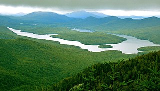
North Elba is a town in Essex County, New York, United States. The population was 7,480 at the 2020 census.

<span class="mw-page-title-main">Ticonderoga, New York</span> Town in New York, United States

Ticonderoga is a town in Essex County, New York, United States. The population was 5,042 at the 2010 census. The name comes from the Mohawk tekontaró:ken, meaning "it is at the junction of two waterways".

Dickinson is a town in Franklin County, New York, United States. The population was 823 at the 2010 census. The town was named after Philemon Dickinson, a brigadier general of the New Jersey militia during the American Revolutionary War.

<span class="mw-page-title-main">Charlton, New York</span> Town in New York, United States

Charlton is a town in Saratoga County, New York, United States. The population was 3,954 at the 2000 census. The town is named after a notable physician.

<span class="mw-page-title-main">Moreau, New York</span> Town in New York, United States

Moreau is a town in Saratoga County, New York, United States. The population was 16,202 at the 2020 census. The town is located in the northeast part of the county, north of Saratoga Springs. Moreau is named after Jean Victor Moreau, a French general, who visited the area just before the town was formed. The town contains a village called South Glens Falls.

<span class="mw-page-title-main">Hampton, New York</span> Town in New York, United States

Hampton is a town in Washington County, New York, United States. It is part of the Glens Falls Metropolitan Statistical Area. The town population was 938 at the 2010 census, an increase of 7.2% since the 2000 census. The town of Hampton is located in the northeastern corner of Washington County.

<span class="mw-page-title-main">Hartford, New York</span> Town in New York, United States

Hartford is a town centrally located in Washington County, New York, United States. It is part of the Glens Falls Metropolitan Statistical Area. The town population was 2,193 at the 2020 census.

<span class="mw-page-title-main">Hebron, New York</span> Town in New York, United States

Hebron is a town in Washington County, New York, United States. It is part of the Glens Falls Metropolitan Statistical Area. The town population was 1,773 at the 2000 census. The town is named after the ancient city of Hebron, in the present-day West Bank.

<span class="mw-page-title-main">Cortlandt, New York</span> Town in New York, United States

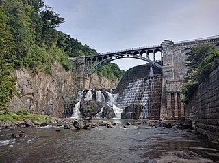
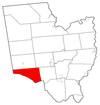
Cortlandt is a town in Westchester County, New York, United States, located at the northwestern edge of the county, at the eastern terminus of the Bear Mountain Bridge. The town includes the villages of Buchanan and Croton-on-Hudson.

<span class="mw-page-title-main">Chatham, New York</span> Town in New York, United States

Chatham is a town in Columbia County, New York, United States. The population was 4,104 at the 2020 census, down from the 2010 census.

<span class="mw-page-title-main">Otego (town), New York</span> Town in New York, United States

Otego is a town in Otsego County, New York, United States. The population was 3,115 at the 2010 census. The name is a native word meaning "where there is fire."

<span class="mw-page-title-main">Unadilla, New York</span> Town in New York, United States

Unadilla is a town in Otsego County, New York, United States. As of the 2010 census, the town had a population of 4,392. The name is derived from an Iroquois word for "meeting place". Unadilla is located in the southwestern corner of the county, southwest of Oneonta. The village of Unadilla is located in the southern part of the town. The mayor of Unadilla is Jason Cotten.

<span class="mw-page-title-main">Stillwater, New York</span> Town in New York, United States

Stillwater is a town in Saratoga County, New York, United States, with a population of 8,287 at the 2010 census. The town contains a village called Stillwater. The town is at the eastern border of the county, southeast of Saratoga Springs and borders both Rensselaer and Washington counties. Saratoga National Historical Park is located within the town's limits. There is a hamlet in Minerva, Essex County, New York, with the same name which has nothing to do with this town.

<span class="mw-page-title-main">Richmondville, New York</span> Town in New York, United States

Richmondville is a town in Schoharie County, New York, United States. The population was 2,466 at the 2020 census. The town name was adapted from the name of a post office in its territory.

<span class="mw-page-title-main">Fair Haven, Vermont</span> Town in Vermont, United States

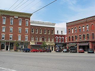
Fair Haven is a town in Rutland County, Vermont, United States. The population was 2,736 at the 2020 census. Within the town is located the census-designated place of Fair Haven. The town is noted for its late 19th century residential and commercial architecture.

<span class="mw-page-title-main">Newfane, New York</span> Town in New York, United States

Newfane is a town in Niagara County, New York, United States. The population was 9,666 at the 2010 census.

<span class="mw-page-title-main">Dryden, New York</span> Town in New York, United States

Dryden is a town in Tompkins County, New York, United States. The population was 14,435 at the 2010 census. The town administers an area that includes two villages, one also named Dryden and one named Freeville, as well as a number of hamlets. The town is on the county's eastern border, east of Ithaca, in the Finger Lakes region.

<span class="mw-page-title-main">Fort Ann, New York</span> Town in New York, United States

Fort Ann is a town in Washington County, New York, United States. It is part of the Glens Falls Metropolitan Statistical Area. The town population was 5,812 at the 2020 census. The town contains a village, also called Fort Ann, located in its southeastern corner.

<span class="mw-page-title-main">Granville (village), New York</span> Village in New York, United States

Granville is a village in Washington County, New York, United States. It is part of the Glens Falls Metropolitan Statistical Area. The village population was 2,543 at the 2010 census.

References

  1. "2016 U.S. Gazetteer Files". United States Census Bureau. Retrieved July 5, 2017.
  2. 1 2 3 4 5 6 7 8 "QuickFacts: Granville town, Washington County, New York". United States Census Bureau . Retrieved November 12, 2022.
  3. Washington County GIS Web Map (Map). Washington County, NY. Archived from the original on January 7, 2010. Retrieved June 18, 2010.
  4. "Metropolitan Areas and Components, 1999, with FIPS Codes". US Census Bureau. Retrieved July 7, 2009.
  5. Gannett, Henry (1905). The Origin of Certain Place Names in the United States. Govt. Print. Off. pp.  142.
  6. "Granville, NY". Village of Granville. Retrieved May 20, 2009.
  7. "Chicago Streets" (PDF). Retrieved February 3, 2011.
  8. "Census of Population and Housing". Census.gov. Retrieved November 12, 2022.
  9. "The Granville sentinel. (Granville, N.Y.) 188?-current, December 31, 1915, Image 6" (1915/12/31). December 31, 1915: 6.{{cite journal}}: Cite journal requires |journal= (help)
  10. 1 2 3 "National Register Information System". National Register of Historic Places . National Park Service. March 13, 2009.
  11. "The Late B.F. Hopkins". Wisconsin State Journal. Madison. January 10, 1870. p. 2. Retrieved November 12, 2022 via newspapers.com.