Hebron, New York

Last updated

Hebron
Washington County New York incorporated and unincorporated areas Hebron highlighted.svg
Location in Washington County and the state of New York.
Coordinates: 43°17′16″N73°20′3″W / 43.28778°N 73.33417°W / 43.28778; -73.33417
Country United States
State New York
County Washington
Area
[1]
  Total56.42 sq mi (146.12 km2)
  Land56.11 sq mi (145.33 km2)
  Water0.31 sq mi (0.79 km2)
Elevation
794 ft (242 m)
Population
 (2010) [2]
  Total1,853
  Estimate 
(2016) [3]
1,809
  Density32.24/sq mi (12.45/km2)
Time zone UTC-5 (Eastern (EST))
  Summer (DST) UTC-4 (EDT)
ZIP codes
12832 and 12865
Area code 518
FIPS code 36-33040
GNIS feature ID0979059
Website Town website

Hebron is a town in Washington County, New York, United States. It is part of the Glens Falls Metropolitan Statistical Area. [4] The town population was 1,773 at the 2000 census. [2] The town is named after the ancient city of Hebron, in the present-day West Bank.

Contents

Geography

Hebron's beautiful hills and valleys are part of the slate valley of the Upper Taconic Mountains (Taghkanic, meaning 'in the trees'), and part of the Great Appalachian Valley (also known as the 'Great Valley'). Thus, many of the main hills, valleys, creeks and roads run diagonally across Hebron in keeping with the general outlay of the Appalachians.

Hebron is notably at once a nexus between valley regions within the 'Great Valley', and also between mountain regions. The nexus of the Champlain and Hudson Valleys (described in greater detail below in the paragraph on watersheds) is located here. The taller peaks of the Taconics are on the Vermont side of the border, and begin to dwindle comparatively into foothills in Hebron. Hebron can be described as the foothills between the Adirondack Mountains of New York, and the Taconic and Green Mountains of Vermont. Hebron thus is at once at a high point dividing valleys, and a lowlands dividing mountain areas.

According to the United States Census Bureau, the town has a total area of 56.4 square miles (146 km2), of which 56.2 square miles (146 km2) is land and 0.2 square miles (0.52 km2) (0.32%) is water.

The eastern town line of Hebron is the Vermont border, and the beginning of New England proper. The town of Salem is adjacent to the south. The towns of Argyle, Hartford and Granville (famous for its colored slate) make up the remaining border on the western and northern edges.

NY Route 22 is a north–south highway through the eastern part of the town, running roughly parallel to the Vermont border. Route 30 connects Salem to Hartford through the western part of Hebron. Route 31, the longest road through Hebron, cuts across diagonally from Route 30 connecting West Hebron to West Pawlet, Vermont.

Hebron is at the threshold between two major watersheds whose waters travel great distances in opposite directions, only to rejoin in the Atlantic Ocean. The formal valleys and watersheds to which Hebron belongs are the following: Champlain Valley/Lake George Watershed—02010001 ; Hudson River Valley/Hudson-Hoosic Watershed—02020003 . Waters in the northernmost part of Hebron drain via the Mettawee River north into Lake Champlain, where they mix with waters from Lake George (Horican) and then flow into the Saint Lawrence River (Kaniatarowanenneh). These Hebron waters mingle in the Saint Lawrence with waters of all the Great Lakes as they flow northeastward into the Gulf of St. Lawrence, and join the Atlantic Ocean. Meanwhile, the majority of Hebron waters drain south via Black Creek into the Batten Kill (Dionondehowa) and then the Hudson River (Muh-he-kun-ne-tuk or Muhheakantuck), and flow south into the Atlantic Ocean just below New York City.

The two branches of Black Creek join in West Hebron just west of the village's main street, and after the waterfall in the West Branch of Black Creek (which is just before Patterson Road). See map . See the approximation of the watershed divide mapped in context of mountains and valleys . See Washington County for a set of contextual maps.

Demographics

Historical population
CensusPop.Note
1820 2,754
1830 2,685−2.5%
1840 2,498−7.0%
1850 2,5482.0%
1860 2,543−0.2%
1870 2,399−5.7%
1880 2,383−0.7%
1890 2,044−14.2%
1900 1,679−17.9%
1910 1,505−10.4%
1920 1,184−21.3%
1930 1,1910.6%
1940 1,2283.1%
1950 1,134−7.7%
1960 1,026−9.5%
1970 1,21218.1%
1980 1,2886.3%
1990 1,54019.6%
2000 1,77315.1%
2010 1,8534.5%
2016 (est.)1,809 [3] −2.4%
U.S. Decennial Census [5]

As of the census [2] of 2000, there were 1,773 people, 687 households, and 489 families residing in the town. The population density was 31.5 inhabitants per square mile (12.2/km2). There were 906 housing units at an average density of 16.1 per square mile (6.2/km2). The racial makeup of the town was 97.18% White, 0.45% African American, 0.06% Native American, 0.45% Asian, 0.79% from other races, and 1.07% from two or more races. Hispanic or Latino of any race were 1.47% of the population.

There were 687 households, out of which 32.3% had children under the age of 18 living with them, 58.2% were married couples living together, 7.7% had a female householder with no husband present, and 28.8% were non-families. 22.1% of all households were made up of individuals, and 10.5% had someone living alone who was 65 years of age or older. The average household size was 2.57 and the average family size was 3.02.

In the town, the population was spread out, with 27.1% under the age of 18, 6.0% from 18 to 24, 28.4% from 25 to 44, 25.4% from 45 to 64, and 13.2% who were 65 years of age or older. The median age was 38 years. For every 100 females, there were 102.6 males. For every 100 females age 18 and over, there were 99.5 males.

The median income for a household in the town was $37,639, and the median income for a family was $41,680. Males had a median income of $28,150 versus $22,315 for females. The per capita income for the town was $18,113. About 7.0% of families and 9.7% of the population were below the poverty line, including 13.7% of those under age 18 and 9.4% of those age 65 or over.

History

Settled in the late 18th century, Hebron was first known as the District of Black Creek. The British Crown granted parcels of land in the area, called "patents," to soldiers who served in the French and Indian War (1754-1763) (the North American front of the Seven Years' War). Most of the grants were to members of the Highland Scottish 77th Regiment. Many of the parcels were transferred from officers and soldiers to speculators, who sold them to New England and Scotch-Irish settlers. Some of the patents that form the town are Lintot, Blundell and Sheriff. Originals of these patents are held by the National Archives.

The town of Hebron was formed March 23, 1786, and named after Hebron, Connecticut. Its namesake is the biblical Hebron, the largest city in the present-day West Bank, 30 km south of Jerusalem.

The main road running north–south through the Hebron area, now named Route 22, used to be known as the “Great Northern Turnpike” (or “the Turnpike”). Two historic milepost markers remain in the town, one at 7047 State Route 22, the second just north of Chamberlin Mills Road. A third is just south of the town line with Salem, New York. A peddler's wagon belonging to Lorenzo Levi Brown of Hebron is in the wagon collection of the Museum of Long Island at Stony Brook, New York.

The town developed as an agricultural community, which it still is today. By 1864, it was the chief potato-producing area of Washington County. Potatoes have been superseded by dairy farming. In recent decades, farms have been consolidated into larger operations. While the town has numerous residents whose families have been in the area for three generations, it also has new part-time residents who have second homes here. Others have retired here for the beauty of the area. [6]

Hebron Volunteer Fire Company

The West Hebron Volunteer Fire Company was formed in 1947. Willard Bain, a charter member, died in February 2008. The first fire truck, BRUSH 356, was put into service in 1947 and operated until 2008. It was retired after the purchase that spring of a CAFS truck ATTACK 356. In 1978, the East Hebron Fire Company was formed after the homes of Nelson Greene and Alfred "Pug" Getty burned down. Getty donated the land and Greene led the group of volunteers who built Station Two. The two companies later merged to form the Hebron Volunteer Fire Company. www.HebronVolunteerFireCompany.com

The Hebron Volunteer Fire Company First Response Team provides emergency medical services to the town. These firefighters/emergency medical technicians (EMTs) respond to medical and trauma-related calls. All first responders are licensed as EMTs by the State of New York. David Getty, a lifelong resident of Hebron, is Fire Chief.

Hebron Preservation Society

The Hebron Preservation Society was chartered by the State of New York in 1975. The Society maintains a museum, with collections held in two historic buildings located on the east side of Route 22 in the hamlet of East Hebron. The former one-room school house built in 1845 was acquired from the Salem School District, and a small tenant farm house, built in the early 19th century, was purchased in 1990. The society published HEBRON: A Century In Review in 1988, with a second edition in 2006. The museum houses a display of school house memorabilia, varied articles, ledgers, books, and family genealogies pertaining to the residents, businesses and organizations in Hebron.

Beauty of Hebron potato

The Beauty of Hebron potato variety was promoted by a local seedsman, Edward L. Coy (E.L. Coy). Both Coy and Rachel Campbell of Hebron took credit for the discovery. The variety was a naturally fertilized seedling of Garnet Chili. The earliest published reference to the Beauty of Hebron variety is from the 1876 Annual Agricultural Society Meeting in Marblehead, Massachusetts. The next year, in 1877 the US Department of Agriculture introduced the Beauty of Hebron potato to growers in 26 states for tests. Various major seed companies of the time claimed credit for its commercial introduction, including J. M. Thornburn of New York City, JJH Gregory of Marblehead, and Peter Henderson of New Jersey.[ citation needed ]

In 1879 Coy shipped "Hebron Beauties" to London. The Beauty of Hebron was one of the varieties used to restock the British Isles after the potato blight and Great Famine of Ireland. Its use spread throughout the British Empire to localities such as New Zealand and New Caledonia. By the turn of the 20th century, it was also a favorite of market and home gardeners in the United States. In 1946, the USDA did not list it in commercial production in the United States, but the 1959 Potato Variety Handbook of the American Potato Association includes the Beauty of Hebron. Most current tissue culture stocks and tubers came from Elmer Hansen of Alberta, Canada; in 1988 he provided seed to Will Bownall and the Seedsavers organization, devoted to preserving historic varieties.[ citation needed ]

The Beauty of Hebron is listed on the RAFT list of Threatened American Foods. [7] The Beauty of Hebron is maintained at the Canadian Potato Research Centre in Fredericton, New Brunswick, Canada; the University of North Dakota Potato Breeding Program; and with a commercial breeder. As of 2008, it was not known if the potato variety was in commercial production. Due to Sally Brillion of the Hebron Preservation Society, amateur gardeners began to cultivate the Beauty of Hebron potato in 2006.[ citation needed ]

Notable people

Locations

There are seven hamlets in the town: Porter, Hebron, North Hebron, East Hebron, West Hebron, Belcher, and Slateville. The Town Clerk's office is located in West Hebron on County Route 30, as is the Hebron Volunteer Fire Company FireHall and Station One. Station Two is located on NY Route 22, south of the intersection of Sheldon Rd, Chamberlain Mill Road and NY-22. Hebron has no school buildings or town center now, but there were hotels, postal offices, and many schools in the past. Students now attend schools in the surrounding towns, primarily Granville and Salem. The northeastern half of Hebron is in the Granville zipcode 12832, and the bulk of the southwestern half is in the Salem zipcode 12865. In 2008, there was only a country store located at Bedlam Corners in the hamlet of West Hebron.

Communities

Geographical features

Related Research Articles

<span class="mw-page-title-main">Washington County, New York</span> County in New York

Washington County is a county in the U.S. state of New York. As of the 2020 census, the population was 61,302. The county seat is Fort Edward. The county was named for U.S. President George Washington. The county is part of the Capital District region of the state.

<span class="mw-page-title-main">Columbia County, New York</span> County in New York, United States

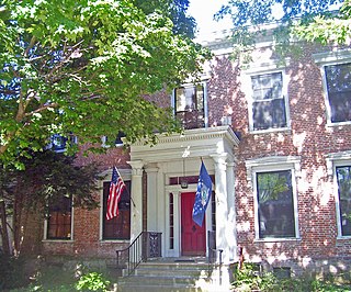
Columbia County is a county in the U.S. state of New York. At the 2020 census, the population was 61,570. The county seat is Hudson. The name comes from the Latin feminine form of the surname of Christopher Columbus, which was at the time of the formation of the county a popular proposal for the name of the United States. The county is part of the Capital District region of the state.

<span class="mw-page-title-main">Hanover, New York</span> Town in New York, United States

Hanover is a town in Chautauqua County, New York, United States. The population was 6,893 at the 2020 census. The town lies in the northeast corner of Chautauqua County.

<span class="mw-page-title-main">Virgil, New York</span> Town in New York, United States

Virgil is a town in Cortland County, New York, United States. The population was 2,401 at the 2010 census. The name is from the Roman poet Virgil. The town is in the southwestern part of Cortland County and is south of the city of Cortland.

<span class="mw-page-title-main">Sardinia, New York</span> Town in New York, United States

Sardinia is a town in Erie County, New York, United States. The town lies in the southeast corner of Erie County and is considered one of the county's "Southtowns". The town is southeast of Buffalo. The population was 2,775 at the 2010 census. The town is reportedly named after an old Christian hymn, Sardinia, and the homonymous Mediterranean island.

<span class="mw-page-title-main">Ohio, New York</span> Town in New York, United States

Ohio is a town in Herkimer County, New York, United States. The population was 1,002 at the 2010 census. The town is named after the state of Ohio. The town is in the northern part of the county and northeast of Utica. Part of Ohio is within the Adirondack Park.

<span class="mw-page-title-main">Maryland, New York</span> Town in New York, United States

Maryland is a town in Otsego County, New York, United States. The population was 1,897 at the 2010 census. It was named for the U.S. state of the same name. The Town of Maryland is on the county's southern border. It is northeast of the City of Oneonta.

<span class="mw-page-title-main">Putnam Valley, New York</span> Town in New York, United States

Putnam Valley is a town in Putnam County, New York, United States. The population was 11,809 at the 2010 census. Its location is northeast of New York City, in the southwestern part of Putnam County. Putnam Valley calls itself the "Town of Lakes".

<span class="mw-page-title-main">Grafton, New York</span> Town in New York, United States

Grafton is a town in Rensselaer County, New York, United States. The population was 2,051 at the 2020 census. It is believed that the town received its name from Grafton, Vermont, where the first town supervisor, Nathaniel Dumbleton, was originally from. The town is an interior town near the north-central part of the county. NY Route 2 passes across the town.

<span class="mw-page-title-main">Jackson, New York</span> Town in New York, United States

Jackson is a town in southeastern Washington County, New York, United States. It is part of the Glens Falls Metropolitan Statistical Area.

<span class="mw-page-title-main">Dorset, Vermont</span> Town in Vermont, United States

Dorset is a town in Bennington County, Vermont, United States. The population was 2,133 at the 2020 census. Dorset is famous for being the location of Cephas Kent's Inn, where four meetings of the Convention that signed the Dorset Accords led to the independent Vermont Republic and future statehood. Dorset is the site of America's oldest marble quarry and is the birthplace of Bill W., co-founder of Alcoholics Anonymous. East Dorset is the site of the Wilson House and the Griffith Library. The town is named after the English county of Dorset.

<span class="mw-page-title-main">Hoosic River</span> River in New York, United States

The Hoosic River, also known as the Hoosac, the Hoosick and the Hoosuck, is a 76.3-mile-long (122.8 km) tributary of the Hudson River in the northeastern United States. The different spellings are the result of varying transliterations of the river's original Algonquian name. It can be translated either as "the beyond place" or as "the stony place".

<span class="mw-page-title-main">Salem, New York</span> Town in New York, United States

Salem is a town in eastern Washington County, New York, United States. It is part of the Glens Falls Metropolitan Statistical Area. The town population was 2,612 at the 2020 census. The town of Salem contains a hamlet also named Salem, formerly an incorporated village.

<span class="mw-page-title-main">New York State Route 55</span> State highway in southern New York, US

New York State Route 55 (NY 55) is a 122.45-mile-long (197.06 km) east-west state highway in southern New York, running from the Pennsylvania state line at the Delaware River in Barryville to the Connecticut state line at Wingdale. It is the only other state highway beside NY 7 to completely cross the state, from border to border, in an east–west direction, although NY 17 does so and is partially east–west. It also forms a concurrency when it joins US 44 for 33 miles (53 km).

<span class="mw-page-title-main">New York State Route 82</span> State highway in New York, US

New York State Route 82 (NY 82) is a state highway in the eastern Hudson Valley of New York in the United States. It begins at an junction with NY 52 northeast of the village of Fishkill, bends eastward towards Millbrook, and then returns westward to end at a junction with U.S. Route 9, NY 9H, and NY 23 at Bell Pond, near Claverack. NY 82 meets the Taconic State Parkway twice; it is the only state highway that has more than one exit with the parkway. The road spans two counties: Dutchess and Columbia.

<span class="mw-page-title-main">Fishkill Creek</span> Tributary of the Hudson River in southern Dutchess County, New York

Fishkill Creek is a tributary of the Hudson River in Dutchess County, New York, United States. At 33.5 miles (53.9 km) it is the second longest stream in the county, after Wappinger Creek. It rises in the town of Union Vale and flows generally southwest to a small estuary on the Hudson just south of Beacon. Part of its 193-square-mile (500 km2) watershed is in Putnam County to the south. Sprout Creek, the county's third-longest creek, is its most significant tributary. Whaley and Sylvan lakes and Beacon Reservoir, its largest, deepest and highest lakes, are among the bodies of water within the watershed.

<span class="mw-page-title-main">New York State Route 217</span> State highway in Columbia County, New York, US

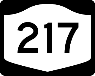
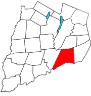
New York State Route 217 (NY 217) is a 6.78-mile (10.91 km) long state highway in Columbia County, New York, in the United States. It connects NY 23 in Claverack-Red Mills and the Taconic State Parkway in Hillsdale, providing a shortcut for drivers heading to and from the Rip Van Winkle Bridge and the Taconic State Parkway northwards of Philmont. The entirety of NY 217 is a rural road with only one lane in each direction separated by a double yellow strip.

<span class="mw-page-title-main">Batten Kill</span> River in New York, United States

The Batten Kill, Battenkill, or Battenkill River is a 59.4-mile-long (95.6 km) river rising in Vermont that flows into New York and is a tributary of the Hudson River. It is the longest Hudson tributary on that river's east. As "kill" means a creek, the name "Battenkill River" is pleonastic.

<span class="mw-page-title-main">Deep Notch</span>

Deep Notch, sometimes West Kill Notch, or Echo Notch, is a mountain pass in Lexington, New York, United States. It divides two Catskill peaks, both subpeaks of high peaks of the range. The narrow groove between the steep, high slopes on either side is traversed by state highway NY 42 and the Shandaken Tunnel, part of the New York City water supply system. It has been called "striking" and "a marvel of grandeur and beauty".

<span class="mw-page-title-main">Argyle, New York</span> Town in New York, United States

Argyle is a town in Washington County, New York, United States. It is part of the Glens Falls Metropolitan Statistical Area. The town population was 3,644 at the 2020 census. The town was named by its many early settlers from Scotland after Argyllshire.

References

  1. "2016 U.S. Gazetteer Files". United States Census Bureau. Retrieved July 5, 2017.
  2. 1 2 3 "U.S. Census website". United States Census Bureau . Retrieved January 31, 2008.
  3. 1 2 "Population and Housing Unit Estimates" . Retrieved June 9, 2017.
  4. "Metropolitan Areas and Components, 1999, with FIPS Codes". US Census Bureau. Retrieved July 7, 2009.
  5. "Census of Population and Housing". Census.gov. Retrieved June 4, 2015.
  6. Town of Hebron, Adirondack.net, accessed February 20, 2012
  7. Renewing America's Food Traditions - RAFT, Center for Sustainable Environments Archived March 11, 2015, at the Wayback Machine
  8. "National Register Information System". National Register of Historic Places . National Park Service. March 13, 2009.