
Red Mountain is a 5,890-foot (1,800-metre) mountain summit located in King County of Washington state. It is set within the Alpine Lakes Wilderness which is part of the Cascade Range. Red Mountain is situated three miles north of Snoqualmie Pass on land managed by Mount Baker-Snoqualmie National Forest. The nearest higher neighbor is Lundin Peak, 0.7 mi (1.1 km) to the northwest. Precipitation runoff on the north side of the mountain drains into Middle Fork of the Snoqualmie River, whereas the south side of the mountain drains into the South Fork Snoqualmie River via Commonwealth Creek.

Kendall Peak is a mountain located on the county line separating King County and Kittitas County of Washington state. It is within the Alpine Lakes Wilderness on the crest of the Cascade Range. Kendall Peak is situated two miles northeast of Snoqualmie Pass on land managed by Mount Baker-Snoqualmie National Forest. Precipitation runoff on the east side of the mountain drains into Silver Creek and makes its way to the Columbia River via Yakima River, whereas the west side of the mountain drains into the South Fork Snoqualmie River via Commonwealth Creek. The Pacific Crest Trail traverses its west flank and an exposed section of the trail called Kendall Katwalk has seen tragic deaths over the years, most recently September 5, 2018. The nearest higher peak is Red Mountain, 0.9 miles (1.4 km) to the north-northwest.

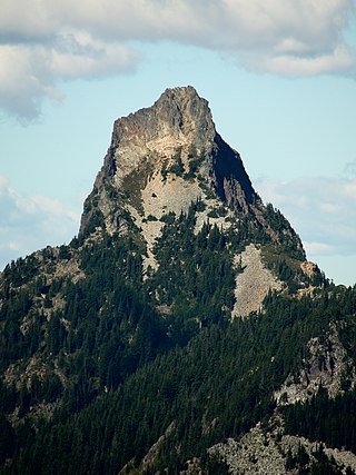
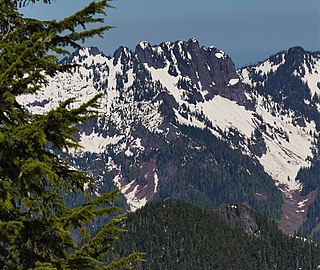
Chair Peak is a 6,238 ft (1,900 m) mountain summit located in east King County of Washington state. It's part of the Cascade Range and is set within the Alpine Lakes Wilderness. Chair Peak is situated three miles northwest of Snoqualmie Pass on land managed by Mount Baker-Snoqualmie National Forest. Precipitation runoff from this mountain drains into tributaries of the Snoqualmie River. Chair Peak is located immediately south of Snow Lake which is a popular hiking destination. The nearest higher neighbor is Kaleetan Peak, 0.57 miles (0.92 km) to the west-northwest.
Kaleetan Peak is a prominent 6,259-foot (1,908-metre) mountain summit located in King County of Washington state. It's part of the Cascade Range and is within the Alpine Lakes Wilderness. Kaleetan Peak is situated four miles northwest of Snoqualmie Pass on land managed by Mount Baker-Snoqualmie National Forest. It's immediately west of Melakwa Pass and Chair Peak, and north of Melakwa Lake. Precipitation runoff on the mountain drains into tributaries of the Snoqualmie River. The nearest higher peak is Snoqualmie Mountain, 2.89 miles (4.65 km) to the east. The mountain's name "Kaleetan" derives from Chinook Jargon which means "arrow".

Huckleberry Mountain is a 6,320+ ft summit located on the shared border of King County and Kittitas County in Washington state.

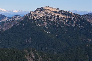
Snowking Mountain is a 7,433-foot (2,266-metre) summit located in Skagit County of Washington state. Situated within the Glacier Peak Wilderness, Snowking Mountain is positioned west of the crest of the North Cascades Range, approximately 18 miles northeast of the town of Darrington. It is set within the Glacier Peak Wilderness, on land managed by Mount Baker–Snoqualmie National Forest. Snowking has two subsidiary peaks, West Peak (7425 ft), and Middle Peak (7400 ft). A broad unnamed glacier known colloquially as Snowking Glacier rests on the north face. Downslope of that glacier are Snowking Lake, Found Lake, and Cyclone Lake. Mount Tommy Thompson is three miles to the northwest, and the nearest higher neighbor is Mount Misch, 5.75 miles (9.25 km) to the southeast. Precipitation runoff from Snowking Mountain drains into tributaries of the Skagit River.

Russian Butte is a double-peak summit located in King County of Washington state. It's located at the western edge of the Cascade Range on land managed by Mount Baker-Snoqualmie National Forest. Russian Butte is more notable for its large, steep rise above local terrain than for its absolute elevation. The nearest higher officially named peak is Preacher Mountain, 3.29 miles (5.29 km) to the east. Little Comrade is a small peak 0.5 mile to the south-southwest of Russian Butte. Precipitation runoff from Russian Butte drains into tributaries of the Snoqualmie River.

Mount Defiance is a 5,584-foot (1,702-metre) mountain summit located in King County of Washington state. It's part of the Cascade Range and is within the Alpine Lakes Wilderness. Mount Defiance is situated 6.5 mi (10.5 km) west of Snoqualmie Pass on land managed by Mount Baker-Snoqualmie National Forest. Precipitation runoff on the mountain drains into tributaries of the Snoqualmie River. The nearest higher peak is Granite Mountain, 3.96 mi (6.37 km) to the east-southeast, and Bandera Mountain is 1.85 mi (2.98 km) to the southeast. Mount Defiance can be reached by trail, with access via the Ira Spring, Talapus Lake, or Pratt Lake trailheads.

Mount Thomson is a prominent 6,554-foot-elevation (1,998-meter) mountain summit in eastern King County of Washington state.
Big Snow Mountain is a prominent 6,680-foot (2,040-metre) mountain summit located 7 mi (11 km) north of Snoqualmie Pass in the Alpine Lakes Wilderness in eastern King County of Washington state. It is part of the Cascade Range and is situated on land managed by Mount Baker-Snoqualmie National Forest. Precipitation runoff from the mountain drains into tributaries of the Snoqualmie and Skykomish Rivers. The nearest higher peak is Overcoat Peak, 3.75 mi (6.04 km) to the east-southeast.

Alaska Mountain is a 5,745-foot (1,751-metre) mountain summit located in the Cascade Range, in Kittitas County of Washington state. It is situated within the Alpine Lakes Wilderness on land managed by Wenatchee National Forest. Alaska Mountain is set between Alaska Lake and Joe Lake, 8 miles (13 km) northeast of Snoqualmie Pass, and 0.81 miles (1.30 km) southeast of Mount Thomson, which is also its nearest higher peak. The Pacific Crest Trail traverses around the south, east and north slopes of Alaska Mountain, and an off-trail hike leads to the summit. Precipitation runoff on the east side of the mountain drains into tributaries of the Yakima River, whereas the west side of the peak drains into tributaries of the Snoqualmie River.
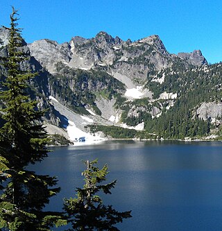
Mount Roosevelt is a 5,835-foot (1,779-metre) mountain summit located 6 mi (10 km) northwest of Snoqualmie Pass, in east King County of Washington state. It's part of the Cascade Range and is situated within the Alpine Lakes Wilderness, on land managed by Mount Baker-Snoqualmie National Forest. Mount Roosevelt is set above the western shore of Snow Lake, and 2 mi (3 km) immediately north of Kaleetan Peak, which is its nearest higher neighbor. Precipitation runoff from the mountain drains into tributaries of the Snoqualmie River. This mountain's name was officially adopted in 1989 by the U.S. Board on Geographic Names.

Mount Fernow is a 6,190-foot (1,890-metre) mountain summit located 6.5 mi (10.5 km) northeast of Skykomish, in eastern King County of Washington state.
Wild Goat Peak is a 6,305-foot (1,922-metre) mountain summit located above the eastern shore of Gold Lake, in eastern King County of Washington state. It's part of the Cascade Range, and is situated in the Alpine Lakes Wilderness, on land managed by Mount Baker-Snoqualmie National Forest. Precipitation runoff from the mountain drains into tributaries of the Snoqualmie and Skykomish Rivers. The nearest higher neighbor is Big Snow Mountain, 1.91 mi (3.07 km) to the southwest. This peak was once called "Big Snowy".

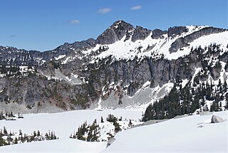
Surprise Mountain is a 6,330-foot (1,930-metre) mountain summit located above the southern end of Glacier Lake, in eastern King County of Washington state. It's part of the Wenatchee Mountains, which are a subset of the Cascade Range, and is situated in the Alpine Lakes Wilderness, on land managed by Mount Baker-Snoqualmie National Forest. Precipitation runoff from the mountain drains into Surprise Creek and Deception Creek, both tributaries of the Skykomish River. The nearest higher neighbor is Thunder Mountain, 0.88 mi (1.42 km) to the northeast, and Terrace Mountain is set 3 mi (4.8 km) to the southwest. The Pacific Crest Trail skirts this peak as it passes through Surprise Gap.

Little Big Chief Mountain is a 7,225-foot (2,202-metre) mountain summit located immediately southwest of Dutch Miller Gap, on the common border separating King County and Kittitas County in Washington state. It is situated within the Alpine Lakes Wilderness, on land managed by Mount Baker-Snoqualmie National Forest. Little Big Chief Mountain is set ten miles northeast of Snoqualmie Pass on the crest of the Cascade Range. Precipitation runoff from the west side of the mountain drains into tributaries of the Snoqualmie River, whereas the east side drains into tributaries of the Yakima River. The nearest higher peak is Summit Chief Mountain, 0.7 miles (1.1 km) to the southwest, and Chimney Rock is set 2.2 miles (3.5 km) to the southwest. The first ascent of this peak was made in August 1939 by Fred Beckey, Wayne Swift, Joe Barto, and Campbell Brooks. This mountain was named for Lorenz A. Nelson during the 1925 Mountaineers climb of Summit Chief Mountain. Nelson was a pioneering mountaineer who led first ascents of Mount Olympus, Mount Meany, and Chiwawa Mountain.

Thunder Mountain is a 6,556-foot (1,998-metre) mountain summit located above the eastern shore of Glacier Lake, on the common border of King County and Chelan County in Washington state. It's part of the Wenatchee Mountains, which are a subset of the Cascade Range, and is situated in the Alpine Lakes Wilderness, on land managed by Mount Baker-Snoqualmie National Forest. Precipitation runoff from the mountain drains west into Surprise Creek, or east into tributaries of Icicle Creek. The nearest higher neighbor is Nimbus Mountain, 0.56 mi (0.90 km) to the northeast, and Surprise Mountain is set 0.88 mi (1.42 km) to the southwest. The Pacific Crest Trail skirts this peak as it passes between Thunder Mountain and Spark Plug Mountain.

Burnt Boot Peak is a 6,520+ ft mountain summit located in the Alpine Lakes Wilderness in eastern King County of Washington state. The peak is part of the Cascade Range and is one mile east of the crest of the range. Burnt Boot Peak is situated 6.5 mi (10.5 km) northeast of Snoqualmie Pass on land managed by Mount Baker-Snoqualmie National Forest. Huckleberry Mountain is set 1.87 mi (3.01 km) to the south, and the nearest higher neighbor is Lemah Mountain, 1.34 mi (2.16 km) to the east. This unofficially-named mountain is located at the head of the officially-named Burnboot Creek, variant spelling Burntboot Creek. Precipitation runoff from the mountain drains south into this creek, or north into Middle Fork Snoqualmie River. The first ascent of this peak was made in August 1963 by Phil Weiser and Clarke Stockwell. The first ascent via the north ridge route was made in June 1971 by Don Williamson, Tom Oas, and Bill Bucher.

La Bohn Peak is a 6,585-foot (2,007-metre) mountain summit located two miles north of Dutch Miller Gap, in east King County of Washington state. It is situated at the head of Necklace Valley, in the heart of the Alpine Lakes Wilderness, on land managed by Mount Baker-Snoqualmie National Forest. La Bohn Peak is set west of La Bohn Lakes and La Bohn Gap, and one mile west of the crest of the Cascade Range. Precipitation runoff from the south side of the mountain drains into tributaries of the Snoqualmie River, whereas the north side drains into tributaries of the Foss River. The nearest higher neighbor is Mount Hinman, 1.7 miles (2.7 km) to the east, Little Big Chief Mountain is set 2.3 miles (3.7 km) to the south, and Iron Cap Mountain sits 1.77 miles (2.85 km) to the west.
Bessemer Mountain is a 5,166-foot-elevation (1,575-meter) mountain summit located in King County of Washington state. It is situated at the western edge of the Cascade Range, on land managed by Mount Baker-Snoqualmie National Forest. Bessemer Mountain is more notable for its large, steep rise above local terrain than for its absolute elevation. Topographic relief is significant as the south aspect rises over 4,200 feet above Middle Fork Snoqualmie River in two miles. Precipitation runoff from this mountain drains into tributaries of the Snoqualmie River.


