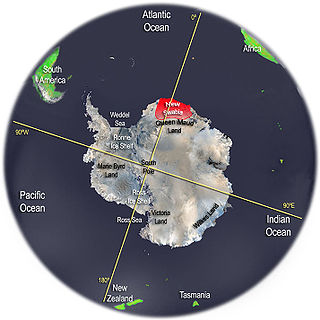
New Swabia was a disputed Antarctic claim by Nazi Germany within the Norwegian territorial claim of Queen Maud Land and is now a cartographic name sometimes given to an area of Antarctica between 20°E and 10°W in Queen Maud Land. New Swabia was explored by Germany in early 1939 and named after that expedition's ship, Schwabenland, itself named after the German region of Swabia.

The Prince Charles Mountains are a major group of mountains in Mac. Robertson Land in Antarctica, including the Athos Range, the Porthos Range, and the Aramis Range. The highest peak is Mount Menzies. Other prominent peaks are Mount Izabelle and Mount Stinear. These mountains together with other scattered peaks form an arc about 260 miles long, extending from the vicinity of Mount Starlight in the north to Goodspeed Nunataks in the south.
Wohlthat Mountains is a large group of associated mountain features consisting of the Humboldt Mountains, Petermann Ranges, and the Gruber Mountains, located immediately east of the Orvin Mountains in Fimbulheimen in the central Queen Maud Land. Discovered by the Third German Antarctic Expedition (1938–1939), led by Capt. Alfred Ritscher, and named for Councilor of state Helmuth C.H. Wohlthat, who as economist and fiscal officer dealt with the organization of the expedition.
The Humboldt Mountains are a group of mountains immediately west of the Petermann Ranges, forming the westernmost portion of the Wohlthat Mountains in Queen Maud Land, Antarctica.
Ufsebrotet Bluff is a steep bluff located 2 miles (3.2 km) south of Mount Zimmermann in the central Gruber Mountains of the Wohlthat Mountains, Queen Maud Land. Discovered and plotted from air photos by German Antarctic Expedition, 1938–39. Replotted from air photos and surveys by Norwegian Antarctic Expedition, 1956–60, and named Ufsebrotet.
Mount Zuckerhut is a peak standing 3.2 km (2.0 mi) southeast of Ritscher Peak in the Gruber Mountains of Queen Maud Land. Discovered and given the descriptive name Zuckerhut (sugarloaf) by the Third German Antarctic Expedition (1938–1939), led by Capt. Alfred Ritscher.
Sandeggtind Peak is a 3,055 metres (10,023 ft) tall peak, standing 1.5 km (1 mi) south of Sandho Heights on Sandegga Ridge in the Conrad Mountains, Queen Maud Land. It was discovered and photographed by the Third German Antarctic Expedition (1938–1939), led by Capt. Alfred Ritscher. It was mapped by Norway from air photos and surveys by NorAE, 1956–60, and named Sandeggtind.
The Mühlig-Hofmann Mountains is a major group of associated mountain features extending east to west for 100 km (62 mi) between the Gjelsvik Mountains and the Orvin Mountains in Queen Maud Land, East Antarctica. With its summit at 3,148 metres (10,328 ft), the massive Jøkulkyrkja Mountain forms the highest point in the Mühlig-Hofmann Mountains.
Ritscher Peak is a 2,790-metre (9,150 ft) peak located 11 kilometres (7 mi) west-southwest of Mount Mentzel in the Gruber Mountains of Queen Maud Land, Antarctica. This peak was discovered and mapped by the Third German Antarctic Expedition of 1938–39 and was named for Capt. Alfred Ritscher, leader of the expedition.
Mount Neustruyev is a peak in East Antarctica, 2,900 m, standing 5 mi NNE of Gneiskopf Peak in Südliche Petermann Range, Wohlthat Mountains, Queen Maud Land.

Anuchin Glacier is a glacier draining southward to Lake Unter-See in the northern part of the Gruber Mountains, Queen Maud Land. It was discovered, and plotted from air photos, by the Third German Antarctic Expedition, 1938–39. It was mapped from air photos and from surveys by the Sixth Norwegian Antarctic Expedition, 1956–60, and remapped by the Soviet Antarctic Expedition, 1960–61, and named after Dmitry Nikolayevich Anuchin, Soviet geographer.
Asimutbreen Glacier is a small, steep tributary glacier to Vangengeym Glacier, descending southeast and then northeast between Solhogdene Heights and Skuggekammen Ridge, in the eastern Gruber Mountains of the Wohlthat Mountains, Queen Maud Land. It was discovered and plotted from air photos by the Third German Antarctic Expedition, 1938–39, replotted from air photos and from surveys by the Sixth Norwegian Antarctic Expedition, 1956–60, and named Asimutbreen.
The Östliche Petermann Range is one of the Petermann Ranges, trending in a north–south direction for 15 nautical miles (28 km) from Per Spur to the Gornyye Inzhenery Rocks, in the Wohlthat Mountains of Queen Maud Land. It was discovered and plotted from air photos by German Antarctic Expedition of 1938–39, and so named by them for its eastern location in the Petermann Ranges.
Mount Schicht is a prominent mountain with several summits, rising 4 nautical miles (7 km) west-southwest of Ritscher Peak in the Gruber Mountains of Queen Maud Land. The feature was discovered by the German Antarctic Expedition under Ritscher, 1938–39, and named Schichtberge because of its appearance.
Sjøbotnen Cirque is the prominent cirque in the north face of the main massif of the Gruber Mountains, situated immediately east of Mount Zimmermann, in the Wohlthat Mountains of Queen Maud Land. It was discovered and plotted from air photos by the German Antarctic Expedition of 1938–39, and replotted from air photos and surveys by the Norwegian Antarctic Expedition, 1956–60, and named Sjøbotnen because the inner part of the feature is occupied by a sizable lake.
Skuggekammen Ridge is a jagged rock ridge extending southeastward from Mount Mentzel, in the Gruber Mountains of the Wohlthat Mountains, Queen Maud Land. Discovered and plotted from air photos by German Antarctic Expedition, 1938–39. Replotted from air photos and surveys by Norwegian Antarctic Expedition, 1956–60, and named Skuggekammen.
Solhogdene Heights is the heights 1 nautical mile (1.9 km) east of Mount Mentzel, overlooking the north side of Asimutbreen Glacier in the eastern Gruber Mountains of the Wohlthat Mountains, Queen Maud Land. Discovered and plotted from air photos by German Antarctic Expedition, 1938–39. Replotted from air photos and surveys by Norwegian Antarctic Expedition, 1956–60, and named Solhogdene.
Todt Ridge is a partially snow-covered ridge, 3 nautical miles (6 km) long, lying 5 nautical miles (9 km) east of Mount Mentzel at the east end of the Gruber Mountains of Queen Maud Land. Discovered by the German Antarctic Expedition, 1938–39, under Captain Alfred Ritscher. Named for Herbert Todt, an assistant to Ritscher who served as home secretary for the expedition.
Vangengeym Glacier is a glacier about 6 nautical miles (11 km) long, draining the vicinity east of Mount Mentzel and flowing north toward Mount Seekopf in the Gruber Mountains, Queen Maud Land. It was discovered and plotted from air photos by the German Antarctic Expedition, 1938–39, and was mapped from air photos and surveys by the Norwegian Antarctic Expedition, 1956–60; remapped by Soviet Antarctic Expedition, 1960–61 and named after Soviet meteorologist Georgiy Vangengeym (1886–1961).

