Hartford, Kansas

Last updated

Hartford, Kansas
College Building 1861 Hartford KS.jpg
College Building (1861)
Lyon County Kansas Incorporated and Unincorporated areas Hartford Highlighted.svg
Location within Lyon County and Kansas
Map of Lyon Co, Ks, USA.png
Coordinates: 38°18′30″N95°57′24″W / 38.30833°N 95.95667°W / 38.30833; -95.95667 [1]
Country United States
State Kansas
County Lyon
Platted 1858
Incorporated 1929 [2]
Government
[2]
  Type Mayor–Council
Area
[3]
  Total0.40 sq mi (1.03 km2)
  Land0.40 sq mi (1.03 km2)
  Water0.00 sq mi (0.00 km2)
Elevation
[1]
1,083 ft (330 m)
Population
 (2020) [4]
  Total355
  Density890/sq mi (340/km2)
Time zone UTC-6 (CST)
  Summer (DST) UTC-5 (CDT)
ZIP code
66854
Area code 620
FIPS code 20-30475
GNIS ID 2394308 [1]

Hartford is a city in Lyon County, Kansas, United States. [1] As of the 2020 census, the population of the city was 355. [4]

Contents

History

Hartford was laid out in 1858. [5] Some of its founders were original natives of Hartford, Connecticut, hence the name. [6] [7]

Hartford was incorporated as a city in March 1884. [8]

Geography

According to the United States Census Bureau, the city has a total area of 0.38 square miles (0.98 km2), all land. [9]

Demographics

Historical population
CensusPop.Note
1890 441
1900 55325.4%
1910 5896.5%
1920 575−2.4%
1930 516−10.3%
1940 491−4.8%
1950 395−19.6%
1960 337−14.7%
1970 47841.8%
1980 55115.3%
1990 541−1.8%
2000 500−7.6%
2010 371−25.8%
2020 355−4.3%
U.S. Decennial Census

Hartford is part of the Emporia Micropolitan Statistical Area.

2020 census

The 2020 United States census counted 355 people, 155 households, and 99 families in Hartford. [10] [11] The population density was 896.5 per square mile (346.1/km2). There were 185 housing units at an average density of 467.2 per square mile (180.4/km2). [11] [12] The racial makeup was 93.52% (332) white or European American (93.52% non-Hispanic white), 0.0% (0) black or African-American, 0.56% (2) Native American or Alaska Native, 0.56% (2) Asian, 0.0% (0) Pacific Islander or Native Hawaiian, 1.13% (4) from other races, and 4.23% (15) from two or more races. [13] Hispanic or Latino of any race was 1.69% (6) of the population. [14]

Of the 155 households, 23.9% had children under the age of 18; 45.8% were married couples living together; 29.0% had a female householder with no spouse or partner present. 30.3% of households consisted of individuals and 13.5% had someone living alone who was 65 years of age or older. [11] The average household size was 2.6 and the average family size was 3.3. [15] The percent of those with a bachelor’s degree or higher was estimated to be 10.1% of the population. [16]

20.8% of the population was under the age of 18, 7.3% from 18 to 24, 22.5% from 25 to 44, 30.4% from 45 to 64, and 18.9% who were 65 years of age or older. The median age was 43.6 years. For every 100 females, there were 82.1 males. [11] For every 100 females ages 18 and older, there were 95.1 males. [11]

The 2016-2020 5-year American Community Survey estimates show that the median household income was $43,250 (with a margin of error of +/- $9,767) and the median family income was $49,583 (+/- $34,107). [17] Males had a median income of $33,500 (+/- $18,987) versus $25,625 (+/- $11,884) for females. The median income for those above 16 years old was $27,500 (+/- $17,605). [18] Approximately, 6.2% of families and 19.6% of the population were below the poverty line, including 27.8% of those under the age of 18 and 0.0% of those ages 65 or over. [19] [20]

2010 census

As of the census [21] of 2010, there were 371 people, 160 households, and 98 families residing in the city. The population density was 976.3 inhabitants per square mile (377.0/km2). There were 193 housing units at an average density of 507.9 per square mile (196.1/km2). The racial makeup of the city was 96.5% White, 0.3% African American, 1.1% Native American, 0.3% Asian, and 1.9% from two or more races. Hispanic or Latino of any race were 2.2% of the population.

There were 160 households, of which 30.6% had children under the age of 18 living with them, 41.3% were married couples living together, 12.5% had a female householder with no husband present, 7.5% had a male householder with no wife present, and 38.8% were non-families. 33.8% of all households were made up of individuals, and 14.4% had someone living alone who was 65 years of age or older. The average household size was 2.25 and the average family size was 2.87.

The median age in the city was 44.6 years. 23.5% of residents were under the age of 18; 8.9% were between the ages of 18 and 24; 18.3% were from 25 to 44; 32.3% were from 45 to 64; and 17% were 65 years of age or older. The gender makeup of the city was 52.3% male and 47.7% female.

2000 census

At the 2000 census, [22] there were 500 people, 200 households and 125 families residing in the city. The population density was 1,329.1 inhabitants per square mile (513.2/km2). There were 220 housing units at an average density of 584.8 per square mile (225.8/km2). The racial makeup of the city was 98.20% White, 0.60% African American, 0.40% Native American, 0.60% from other races, and 0.20% from two or more races. Hispanic or Latino of any race were 0.40% of the population.

There were 200 households, of which 33.0% had children under the age of 18 living with them, 51.0% were married couples living together, 9.5% had a female householder with no husband present, and 37.5% were non-families. 33.5% of all households were made up of individuals, and 11.5% had someone living alone who was 65 years of age or older. The average household size was 2.35 and the average family size was 3.06.

26.0% of the population were under the age of 18, 5.8% from 18 to 24, 29.4% from 25 to 44, 24.0% from 45 to 64, and 14.8% who were 65 years of age or older. The median age was 39 years. For every 100 females, there were 104.1 males. For every 100 females age 18 and over, there were 103.3 males.

The median household income was $34,750 and the median family income was $37,212. Males had a median income of $27,212 versus $23,250 for females. The per capita income for the city was $16,014. About 4.6% of families and 9.3% of the population were below the poverty line, including 5.0% of those under age 18 and 7.8% of those age 65 or over.

Education

The community is served by Southern Lyon County USD 252 public school district.

See also

Related Research Articles

<span class="mw-page-title-main">Latham, Kansas</span> City in Butler County, Kansas

Latham is a city in Butler County, Kansas, United States. As of the 2020 census, the population of the city was 96.

<span class="mw-page-title-main">Cedar Vale, Kansas</span> City in Chautauqua County, Kansas

Cedar Vale is a city in Chautauqua County, Kansas, United States. As of the 2020 census, the population of the city was 476.

<span class="mw-page-title-main">Green, Kansas</span> City in Clay County, Kansas

Green is a city in Clay County, Kansas, United States. As of the 2020 census, the population of the city was 95.

<span class="mw-page-title-main">Mulberry, Kansas</span> City in Crawford County, Kansas

Mulberry is a city in Crawford County, Kansas, United States. As of the 2020 census, the population of the city was 409.

<span class="mw-page-title-main">Ensign, Kansas</span> City in Gray County, Kansas

Ensign is a city in Gray County, Kansas, United States. As of the 2020 census, the population of the city was 166. It is located along U.S. Route 56 highway.

<span class="mw-page-title-main">Jetmore, Kansas</span> City in Hodgeman County, Kansas

Jetmore is a city in and the county seat of Hodgeman County, Kansas, United States. As of the 2020 census, the population of the city was 770.

<span class="mw-page-title-main">Oskaloosa, Kansas</span> City and County seat in Kansas, United States

Oskaloosa is a city in and the county seat of Jefferson County, Kansas, United States. As of the 2020 census, the population of the city was 1,110.

<span class="mw-page-title-main">Lakin, Kansas</span> City in Kearny County, Kansas

Lakin is a city in and the county seat of Kearny County, Kansas, United States. As of the 2020 census, the population of the city was 2,205. It is located along Highway 50.

<span class="mw-page-title-main">Mound Valley, Kansas</span> City in Labette County, Kansas

Mound Valley is a city in Labette County, Kansas, United States. As of the 2020 census, the population of the city was 348.

<span class="mw-page-title-main">Dighton, Kansas</span> City in Lane County, Kansas

Dighton is a city in and the county seat of Lane County, Kansas, United States. As of the 2020 census, the population of the city was 960. Dighton is named for Dick Dighton, a surveyor.

<span class="mw-page-title-main">Lansing, Kansas</span> City in Kansas, United States

Lansing is a city in Leavenworth County, Kansas, United States. It is situated along the west side of the Missouri River and Kansas-Missouri state border. As of the 2020 census, the population of the city was 11,239. It is the second most populous city of Leavenworth County and is a part of the Kansas City metropolitan area. The Lansing Correctional Facility, which includes the state's main maximum-security prison, is located in Lansing.

<span class="mw-page-title-main">Marysville, Kansas</span> City in Marshall County, Kansas

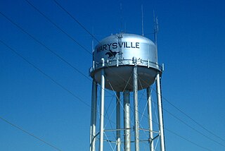
Marysville is a city in and the county seat of Marshall County, Kansas, United States. As of the 2020 census, the population of the city was 3,447.

<span class="mw-page-title-main">Oketo, Kansas</span> City in Marshall County, Kansas

Oketo is a city in Marshall County, Kansas, United States. As of the 2020 census, the population of the city was 64.

<span class="mw-page-title-main">Meade, Kansas</span> City in Meade County, Kansas

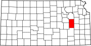
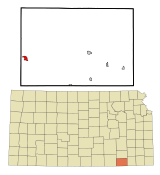
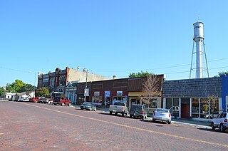
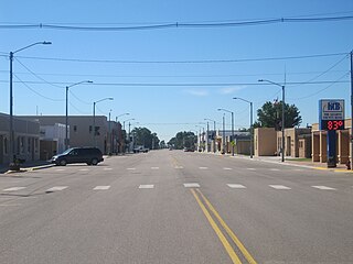
Meade is a city in and the county seat of Meade County, Kansas, United States. As of the 2020 census, the population of the city was 1,505.

<span class="mw-page-title-main">Ness City, Kansas</span> City in Ness County, Kansas

Ness City is a city in and the county seat of Ness County, Kansas, United States. As of the 2020 census, the population of the city was 1,329. Ness City is famous for its four-story Old Ness County Bank Building located downtown, and nicknamed Skyscraper of the Plains.

<span class="mw-page-title-main">Lyndon, Kansas</span> City in Osage County, Kansas

Lyndon is a city in, and the county seat of Osage County, Kansas, United States. As of the 2020 census, the population of the city was 1,037.

<span class="mw-page-title-main">Belleville, Kansas</span> City in Republic County, Kansas

Belleville is a city in and the county seat of Republic County, Kansas, United States. As of the 2020 census, the population of the city was 2,007.

<span class="mw-page-title-main">Clearwater, Kansas</span> City in Sedgwick County, Kansas

Clearwater is a city in Sedgwick County, Kansas, United States. As of the 2020 census, the population of the city was 2,653.

<span class="mw-page-title-main">Mayfield, Kansas</span> City in Sumner County, Kansas

Mayfield is a city in Sumner County, Kansas, United States. As of the 2020 census, the population of the city was 75.

<span class="mw-page-title-main">Lake Quivira, Kansas</span> City in Kansas, United States

Lake Quivira is a city in Johnson and Wyandotte counties in the State of Kansas, and part of the Kansas City Metropolitan Area. As of the 2020 census, the population of the city was 1,014.

References

  1. 1 2 3 4 U.S. Geological Survey Geographic Names Information System: Hartford, Kansas
  2. 1 2 "City of Hartford". The League of Kansas Municipalities. May 24, 2019.
  3. "2019 U.S. Gazetteer Files". United States Census Bureau. Retrieved July 24, 2020.
  4. 1 2 "Profile of Hartford, Kansas in 2020". United States Census Bureau. Archived from the original on May 3, 2022. Retrieved May 3, 2022.
  5. Blackmar, Frank Wilson (1912). Kansas: A Cyclopedia of State History, Embracing Events, Institutions, Industries, Counties, Cities, Towns, Prominent Persons, Etc. Standard Publishing Company. pp.  812.
  6. Gannett, Henry (1905). The Origin of Certain Place Names in the United States. Govt. Print. Off. pp.  151.
  7. Heim, Michael (2007). Exploring Kansas Highways. p. 9. ISBN   9780974435886.
  8. French, Laura M. (1929). History of Emporia and Lyon County, Kansas. Heritage Books. p. 131. ISBN   9780788403460.
  9. "US Gazetteer files 2010". United States Census Bureau . Retrieved July 6, 2012.
  10. "US Census Bureau, Table P16: HOUSEHOLD TYPE". data.census.gov. Retrieved January 3, 2024.
  11. 1 2 3 4 5 "US Census Bureau, Table DP1: PROFILE OF GENERAL POPULATION AND HOUSING CHARACTERISTICS". data.census.gov. Retrieved January 3, 2024.
  12. Bureau, US Census. "Gazetteer Files". Census.gov. Retrieved December 30, 2023.
  13. "US Census Bureau, Table P1: RACE". data.census.gov. Retrieved January 3, 2024.
  14. "US Census Bureau, Table P2: HISPANIC OR LATINO, AND NOT HISPANIC OR LATINO BY RACE". data.census.gov. Retrieved January 3, 2024.
  15. "US Census Bureau, Table S1101: HOUSEHOLDS AND FAMILIES". data.census.gov. Retrieved January 3, 2024.
  16. "US Census Bureau, Table S1501: EDUCATIONAL ATTAINMENT". data.census.gov. Retrieved January 3, 2024.
  17. "US Census Bureau, Table S1903: MEDIAN INCOME IN THE PAST 12 MONTHS (IN 2020 INFLATION-ADJUSTED DOLLARS)". data.census.gov. Retrieved January 3, 2024.
  18. "US Census Bureau, Table S2001: EARNINGS IN THE PAST 12 MONTHS (IN 2020 INFLATION-ADJUSTED DOLLARS)". data.census.gov. Retrieved January 3, 2024.
  19. "US Census Bureau, Table S1701: POVERTY STATUS IN THE PAST 12 MONTHS". data.census.gov. Retrieved January 3, 2024.
  20. "US Census Bureau, Table S1702: POVERTY STATUS IN THE PAST 12 MONTHS OF FAMILIES". data.census.gov. Retrieved January 3, 2024.
  21. "U.S. Census website". United States Census Bureau . Retrieved July 6, 2012.
  22. "U.S. Census website". United States Census Bureau . Retrieved January 31, 2008.

Further reading