Hartland, Maine

Last updated

Hartland, Maine
USA Maine location map.svg
Red pog.svg
Hartland, Maine
Location within the state of Maine
Coordinates: 44°52′55″N69°27′2″W / 44.88194°N 69.45056°W / 44.88194; -69.45056
CountryUnited States
State Maine
County Somerset County
IncorporationFebruary 17, 1820
Area
[1]
  Total42.95 sq mi (111.24 km2)
  Land37.10 sq mi (96.09 km2)
  Water5.85 sq mi (15.15 km2)
Population
 (2020)
  Total1,705
  Density46/sq mi (17.7/km2)
Time zone UTC-5 (Eastern (EST))
  Summer (DST) UTC-4 (EDT)

Hartland is a town in Somerset County, Maine, United States. The population was 1,705 at the 2020 census. [2]

Contents

History

The area was first settled in approximately 1800, and was incorporated as Warrentown or Warrenton on February 17, 1820. [3] [4] It was the last town in Maine to be incorporated by the Massachusetts General Court before the Missouri Compromise which led to the birth of the state of Maine, three weeks later.

The area did not gain a library collection until 1903 when materials started being housed in the town hall. [5] From 1935 to 1990 the library collection could be found on Commercial St in a building that now houses the Irving Tannery Outlet. In 1991 the library moved to its current location. In 1995 thanks to a donation from the tannery, the library added space for a community room and children's materials. [5]

It is the mission of the Hartland Public Library to assemble, organize, preserve, and make easily available books and other materials which will best meet the needs of the community. The library's collection houses more than 35,000 books and seven computers which are open to the public. There is also a meeting room which can be used for community events. Hartland Public Library is governed by a board of trustees

Geography

According to the United States Census Bureau, the town has a total area of 42.95 square miles (111.24 km2), of which 37.10 square miles (96.09 km2) is land and 5.85 square miles (15.15 km2) is water. [1]

Demographics

Historical population
CensusPop.Note
1820 411
1830 71874.7%
1840 1,02843.2%
1850 960−6.6%
1860 1,0509.4%
1870 1,1206.7%
1880 1,047−6.5%
1890 974−7.0%
1900 1,11514.5%
1910 1,1765.5%
1920 1,140−3.1%
1930 1,1551.3%
1940 1,2407.4%
1950 1,3105.6%
1960 1,44710.5%
1970 1,414−2.3%
1980 1,66918.0%
1990 1,8068.2%
2000 1,8160.6%
2010 1,782−1.9%
2020 1,705−4.3%
U.S. Decennial Census [6]

2010 census

As of the census [7] of 2010, there were 1,782 people, 741 households, and 482 families living in the town. The population density was 48.0 inhabitants per square mile (18.5/km2). There were 1,109 housing units at an average density of 29.9 per square mile (11.5/km2). The racial makeup of the town was 97.0% White, 0.5% African American, 0.3% Native American, 0.4% Asian, 0.3% from other races, and 1.5% from two or more races. Hispanic or Latino of any race were 1.0% of the population.

There were 741 households, of which 26.7% had children under the age of 18 living with them, 48.3% were married couples living together, 11.7% had a female householder with no husband present, 5.0% had a male householder with no wife present, and 35.0% were non-families. 26.6% of all households were made up of individuals, and 12.9% had someone living alone who was 65 years of age or older. The average household size was 2.38 and the average family size was 2.80.

The median age in the town was 45.2 years. 21% of residents were under the age of 18; 7.7% were between the ages of 18 and 24; 20.8% were from 25 to 44; 32.3% were from 45 to 64; and 18.1% were 65 years of age or older. The gender makeup of the town was 48.3% male and 51.7% female.

2000 census

As of the census [8] of 2000, there were 1,816 people, 707 households, and 492 families living in the town. The population density was 49.0 inhabitants per square mile (18.9/km2). There were 1,077 housing units at an average density of 29.1 per square mile (11.2/km2). The racial makeup of the town was 98.07% White, 0.22% Black or African American, 0.66% Native American, 0.06% Asian, 0.06% Pacific Islander, 0.06% from other races, and 0.88% from two or more races. Hispanic or Latino of any race were 0.50% of the population.

There were 707 households, out of which 31.0% had children under the age of 18 living with them, 53.2% were married couples living together, 10.7% had a female householder with no husband present, and 30.4% were non-families. 23.8% of all households were made up of individuals, and 9.8% had someone living alone who was 65 years of age or older. The average household size was 2.48 and the average family size was 2.88.

In the town, the population was spread out, with 24.1% under the age of 18, 8.0% from 18 to 24, 27.9% from 25 to 44, 24.9% from 45 to 64, and 15.1% who were 65 years of age or older. The median age was 39 years. For every 100 females, there were 93.6 males. For every 100 females age 18 and over, there were 94.2 males.

The median income for a household in the town was $29,573, and the median income for a family was $35,400. Males had a median income of $26,522 versus $21,273 for females. The per capita income for the town was $13,629. About 11.7% of families and 17.0% of the population were below the poverty line, including 20.0% of those under age 18 and 17.7% of those age 65 or over.

Related Research Articles

<span class="mw-page-title-main">Frenchville, Maine</span> Town in the state of Maine, United States

Frenchville is a town in Aroostook County, Maine, United States. The population was 1,052 at the 2020 census.

<span class="mw-page-title-main">Island Falls, Maine</span> Town in the state of Maine, United States

Island Falls is a town in Aroostook County, Maine, United States. The population was 758 at the 2020 census. The primary village of Island Falls in the town is situated at a falls in the West Branch Mattawamkeag River.

<span class="mw-page-title-main">Littleton, Maine</span> Town in the state of Maine, United States

Littleton is a town in Aroostook County, Maine, United States. The population was 997 at the 2020 census.

<span class="mw-page-title-main">Perham, Maine</span> Town in the state of Maine, United States

Perham is a town in Aroostook County, Maine, United States. The population was 371 at the 2020 census. The town was named after Maine's 33rd governor, Sidney Perham.

<span class="mw-page-title-main">Sherman, Maine</span> Town in the state of Maine, United States

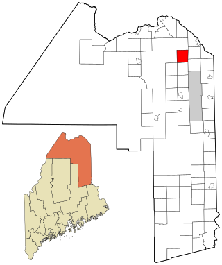
Sherman is a town in Aroostook County, Maine, United States. The population was 815 at the 2020 census.

<span class="mw-page-title-main">Stockholm, Maine</span> Town in the state of Maine, United States

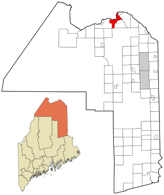
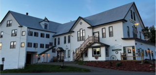
Stockholm is a town in Aroostook County, Maine, United States. The population was 250 at the 2020 census.

<span class="mw-page-title-main">Chesterville, Maine</span> Town in Maine, United States

Chesterville is a town in Franklin County, Maine, United States. The population was 1,328 at the 2020 census.

<span class="mw-page-title-main">Penobscot, Maine</span> Town in the state of Maine, United States

Penobscot is a town in Hancock County, Maine, United States. The Bagaduce River flows through the town. The population was 1,136 at the 2020 census.

<span class="mw-page-title-main">Trenton, Maine</span> Town in the state of Maine, United States

Trenton is a town in Hancock County, Maine, United States, near Acadia National Park. The population was 1,584 at the 2020 census. Hancock County-Bar Harbor Airport is located in Trenton.

<span class="mw-page-title-main">Hartford, Maine</span> Town in the state of Maine, United States

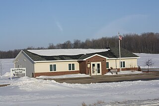
Hartford is a town in Oxford County, Maine, United States. Hartford is included in the Lewiston-Auburn, Maine metropolitan New England City and Town Area. The population was 1,203 at the 2020 census.

Bradley is a town in Penobscot County, Maine, United States. It is part of the Bangor Metropolitan Statistical Area. The population was 1,532 at the 2020 census. The village of Bradley is in the northwestern corner of the town.

Garland is a town in Penobscot County, Maine, United States. The population was 1,026 at the 2020 census.

Winn is a town in Penobscot County, Maine, United States, on the east bank of the Penobscot River. The town was named for John M. Winn, an early landholder. The population was 399 at the 2020 census.

<span class="mw-page-title-main">Abbot, Maine</span> Town in the state of Maine, United States

Abbot is a town in Piscataquis County, Maine, United States. The population was 650 at the 2020 census. It was named for the treasurer of Bowdoin College, John Abbot.

<span class="mw-page-title-main">Smithfield, Maine</span> Town in the state of Maine, United States

Smithfield is a town in Somerset County, Maine, United States. The population was 925 at the 2020 census. The town was incorporated on February 29, 1840, making it the only town in Maine incorporated on Leap Day. The town was named after the Rev. Henry Smith, an early settler.

<span class="mw-page-title-main">Burnham, Maine</span> Town in the state of Maine, United States

Burnham is a town in Waldo County, Maine, United States. The population was 1,096 at the 2020 census.

<span class="mw-page-title-main">Hartland, Vermont</span> Town in Vermont, United States

Hartland is a town in Windsor County, Vermont, United States. The population was 3,446 at the 2020 census. It includes the villages of Hartland, Hartland Four Corners, and North Hartland.

<span class="mw-page-title-main">Hartland, Shawano County, Wisconsin</span> Town in Wisconsin, United States

Hartland is a town in Shawano County, Wisconsin, United States. The population was 825 at the 2000 census. The unincorporated community of Slab City is located within the town. The unincorporated communities of Frazer Corners and Zachow are also located partially in the town. Hartland was established in 1859.

<span class="mw-page-title-main">East Millinocket, Maine</span> Town in the state of Maine, United States

East Millinocket is a town in Penobscot County, Maine, United States. The population was 1,572 at the 2020 census.

Hartland is a census-designated place (CDP) in the town of Hartland in Somerset County, Maine, United States. The population was 756 at the 2020 census.

References

  1. 1 2 "US Gazetteer files 2010". United States Census Bureau . Retrieved December 16, 2012.
  2. "Census - Geography Profile: Hartland town, Somerset County, Maine" . Retrieved January 19, 2022.
  3. Maine Encyclopedia
  4. Official Register of the United States
  5. 1 2 "About the Library". November 12, 2017.
  6. "Census of Population and Housing". Census.gov. Retrieved June 4, 2015.
  7. "U.S. Census website". United States Census Bureau . Retrieved December 16, 2012.
  8. "U.S. Census website". United States Census Bureau . Retrieved January 31, 2008.