Rockwell is a city in Cerro Gordo County, Iowa, United States. The population was 1,071 at the time of the 2020 census. It is part of the Mason City Micropolitan Statistical Area.

Chelsea is a town in Kennebec County, Maine, United States. The population was 2,778 at the 2020 census. It is home to the Togus Veterans Administration facilities.

Manchester is a town in Kennebec County, Maine, United States, located at 44.33°N 69.87°W. The population was 2,456 at the 2020 census. The southern part of the town bordering Cobbosseecontee Lake is a popular recreation spot in central Maine, and part of the Winthrop Lakes Region. Manchester is included in the Augusta, Maine micropolitan and included in the Lewiston-Auburn, Maine metropolitan New England City and Town Area.

Pittston is a town in Kennebec County, Maine, United States. The population was 2,875 at the 2020 census. The town was named after the family of John Pitt, who were early settlers. Pittston is included in the Augusta, Maine micropolitan New England City and Town Area.

Sidney is a town in Kennebec County, Maine, United States. The population was 4,645 at the 2020 census. Sidney was incorporated as a town on January 30, 1792. The town was named for Sir Philip Sidney, an English author. Sidney is included in the Augusta, Maine micropolitan New England City and Town Area. Since 1937, the town has been the home of the New England Music Camp.

Wayne is a town in Kennebec County, Maine, United States. Wayne is included in the Lewiston-Auburn, Maine metropolitan New England city and town area. The population was 1,129 at the 2020 census. The town was named after Revolutionary War General Anthony Wayne. During the summer, Wayne is home to Camp Androscoggin. A popular recreation spot in central Maine, Wayne is part of the Winthrop Lakes Region. The town is included in the Augusta, Maine micropolitan New England City and Town Area. and included in the Lewiston-Auburn, Maine metropolitan New England city and town area.
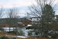
Bradley is a town in Penobscot County, Maine, United States. It is part of the Bangor Metropolitan Statistical Area. The population was 1,532 at the 2020 census. The village of Bradley is in the northwestern corner of the town.
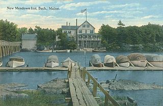
West Bath is a town in Sagadahoc County, Maine, United States. The population was 1,910 at the 2020 census. A sub-locality of West Bath is Winnegance. West Bath is part of the Portland–South Portland–Biddeford, Maine metropolitan statistical area.
Detroit is a town in Somerset County, Maine, United States. The population was 885 at the 2020 census.
Cooper is a town in Washington County, Maine, United States. The community was named after General John Cooper, a landowner. The population was 168 at the 2020 census.

Cutler is a town in Washington County, Maine, United States. The town was named after Joseph Cutler, an early settler, who hailed from Newburyport, Massachusetts. The population was 524 at the 2020 census.
Meddybemps is a town in Washington County, Maine, United States. The population was 139 at the 2020 census.
Green Township is a township in Forest County, Pennsylvania, United States. The population was 371 at the 2020 census, down from 522 in 2010, which was, in turn, an increase from 397 in 2000.

Oliver Township is a township in Mifflin County, Pennsylvania, United States. The population was 2,060 at the time of the 2020 census.

Jackson Township is a township in Venango County, Pennsylvania, United States. The population was 917 at the 2020 census, a decrease from 1,147 in 2010, which represented, in turn, a decline from 1,168 as of the 2000 census.

Oakland Township is a township in Venango County, Pennsylvania, United States. The population was 1,359 at the 2020 census, a decrease from 1,504 in 2010, which represented a decline from the 1,565 residents as of the 2000 census.

Kennebec is a town in and county seat of Lyman County, South Dakota, United States. The population was 281 at the 2020 census.

Randolph is a town and a census-designated place (CDP) in Kennebec County, Maine, United States. The population was 1,743 at the 2020 census. The town was named for Randolph, Massachusetts. Randolph is included in the Augusta, Maine micropolitan New England City and Town Area.

Clinton is a town in Kennebec County, Maine, United States. The town was named for New York Governor DeWitt Clinton. The population was 3,370 at the 2020 census. The main village in town is the Clinton census-designated place, with a population of 1,386 at the 2020 census.

Farmingdale is a census-designated place (CDP) in the town of Farmingdale in Kennebec County, Maine, United States. The population was 1,970 at the 2010 census, out of 2,956 in the entire town.