Peru, Maine

Last updated

Peru, Maine
Peru, ME.jpg
Bird's-eye View
USA Maine location map.svg
Red pog.svg
Peru, Maine
Location within the state of Maine
Coordinates: 44°29′41″N70°26′14″W / 44.49472°N 70.43722°W / 44.49472; -70.43722
Country United States
State Maine
County Oxford
Incorporated1821
Area
[1]
  Total47.60 sq mi (123.28 km2)
  Land46.68 sq mi (120.90 km2)
  Water0.92 sq mi (2.38 km2)
Elevation
807 ft (246 m)
Population
 (2020)
  Total1,488
  Density32/sq mi (12.3/km2)
Time zone UTC-5 (Eastern (EST))
  Summer (DST) UTC-4 (EDT)
ZIP code
04290
Area code 207
FIPS code 23-58270
GNIS feature ID0582673

Peru is a town in Oxford County, Maine, United States. Peru is included in the Lewiston-Auburn, Maine metropolitan New England city and town area. The population was 1,488 at the 2020 census. [2]

Contents

History

It was granted by the Massachusetts General Court to several residents from Falmouth, Maine. The first grantee to settle would be Merrill Knight in 1793. Organized in 1812 as Plantation Number 1 (also Thompsontown), it was incorporated on February 5, 1821, as the 240th town in Maine. Peru was named in the spirit of liberty and solidarity for Peru, the South American country which declared independence from Spain on July 28, 1821. [3]

With dark soil free from stones, farming was an early industry. The chief crop was hay, and raising sheep became a common occupation. In addition, there were five sawmills which manufactured long and short lumber, as well as specialty products like wooden bowls. In 1870, the population was 931. [4]

Formerly possessing an independent public school department, Peru joined Maine School Administrative District 21 in 2006. It has since moved to RSU (Regional School Unit) #10 in 2009 and then to RSU #56 in 2017 with Canton, Carthage and Dixfield. [5]

Geography

According to the United States Census Bureau, the town has a total area of 47.60 square miles (123.28 km2), of which 46.68 square miles (120.90 km2) is land and 0.92 square miles (2.38 km2) is water. [1] Peru is drained by the Androscoggin River. Worthley Pond, two miles long by one-half mile wide, is in the southern part of the town. The tallest mountains are Mt. Zircon (2221 ft), Black Mountain (2129 ft) and Speckled Mountain (2116 ft).

Demographics

Historical population
CensusPop.Note
1820 343
1830 66694.2%
1840 1,00250.5%
1850 1,10910.7%
1860 1,1211.1%
1870 931−16.9%
1880 825−11.4%
1890 692−16.1%
1900 77311.7%
1910 746−3.5%
1920 738−1.1%
1930 82611.9%
1940 96516.8%
1950 1,08011.9%
1960 1,22913.8%
1970 1,3459.4%
1980 1,56416.3%
1990 1,541−1.5%
2000 1,515−1.7%
2010 1,5411.7%
2020 1,488−3.4%
U.S. Decennial Census [6]

2020 census

As of the census [7] of 2020, there were 1,488 people, 697 households, and 429 families living in the town. Peru had 907 housing units. The median age was 49.4.

The racial makeup of the town was 94.4% White, 0.5% Native American, 0.3% Asian, 0.5% from other races, and 4.0% from two or more races. Hispanic or Latino of any race were 0.9% of the population.

There were 624 households, of which 24.3% had children under the age of 18 living with them, 51.1% were married couples living together, 19.3% had a female householder with no husband present, 17.7% had a male householder with no wife present, and 33.7% were non-families. 27.1% of all households were made up of individuals, and 12.6% had someone living alone who was 65 years of age or older. The average household size was 2.44 and the average family size was 3.02.

2010 census

As of the census [8] of 2010, there were 1,541 people, 629 households, and 446 families living in the town. The population density was 33.0 inhabitants per square mile (12.7/km2). There were 909 housing units at an average density of 19.5 per square mile (7.5/km2). The racial makeup of the town was 97.6% White, 0.6% Native American, 0.3% Asian, 0.3% from other races, and 1.1% from two or more races. Hispanic or Latino of any race were 0.3% of the population.

There were 629 households, of which 28.1% had children under the age of 18 living with them, 57.2% were married couples living together, 7.8% had a female householder with no husband present, 5.9% had a male householder with no wife present, and 29.1% were non-families. 22.3% of all households were made up of individuals, and 12% had someone living alone who was 65 years of age or older. The average household size was 2.45 and the average family size was 2.82.

The median age in the town was 47 years. 18.9% of residents were under the age of 18; 8.3% were between the ages of 18 and 24; 20.4% were from 25 to 44; 36.3% were from 45 to 64; and 16.1% were 65 years of age or older. The gender makeup of the town was 49.5% male and 50.5% female.

2000 census

As of the census [9] of 2000, there were 1,515 people, 585 households, and 436 families living in the town. The population density was 32.3 inhabitants per square mile (12.5/km2). There were 849 housing units at an average density of 18.1 per square mile (7.0/km2). The racial makeup of the town was 99.27% White, 0.33% Native American, 0.13% Asian, and 0.26% from two or more races. Hispanic or Latino of any race were 0.40% of the population.

There were 585 households, out of which 35.0% had children under the age of 18 living with them, 63.8% were married couples living together, 5.6% had a female householder with no husband present, and 25.3% were non-families. 19.8% of all households were made up of individuals, and 7.9% had someone living alone who was 65 years of age or older. The average household size was 2.59 and the average family size was 2.98.

West Peru from Dixfield in 1906 Toll Bridge Between Dixfield and West Peru, ME.jpg
West Peru from Dixfield in 1906

In the town, the population was spread out, with 26.7% under the age of 18, 5.8% from 18 to 24, 28.2% from 25 to 44, 24.2% from 45 to 64, and 15.1% who were 65 years of age or older. The median age was 40 years. For every 100 females, there were 99.9 males. For every 100 females age 18 and over, there were 99.8 males.

The median income for a household in the town was $38,083, and the median income for a family was $43,047. Males had a median income of $32,171 versus $23,214 for females. The per capita income for the town was $16,383. About 3.4% of families and 6.0% of the population were below the poverty line, including 3.8% of those under age 18 and 7.0% of those age 65 or over.

Notable people

Related Research Articles

<span class="mw-page-title-main">Wales, Maine</span> Town in the state of Maine, United States

Wales is a town in Androscoggin County, Maine, United States. The population was 1,608 at the 2020 census. It is included in both the Lewiston-Auburn, Maine Metropolitan Statistical Area and the Lewiston-Auburn, Maine Metropolitan New England City and Town Area.

<span class="mw-page-title-main">Castle Hill, Maine</span> Town in the state of Maine, United States

Castle Hill is a town in Aroostook County, Maine, United States. The population was 373 people at the 2020 census.

<span class="mw-page-title-main">Masardis, Maine</span> Town in Maine, United States

Masardis is a town in Aroostook County, Maine, United States. The population was 204 at the 2020 census.

<span class="mw-page-title-main">Oakfield, Maine</span> Town in the state of Maine, United States

Oakfield is a town in Aroostook County, Maine, United States. The population was 661 at the 2020 census. The village of Oakfield, listed as a census-designated place, is in the northwestern corner of the town.

<span class="mw-page-title-main">Perham, Maine</span> Town in the state of Maine, United States

Perham is a town in Aroostook County, Maine, United States. The population was 371 at the 2020 census. The town was named after Maine's 33rd governor, Sidney Perham.

<span class="mw-page-title-main">Sherman, Maine</span> Town in the state of Maine, United States

Sherman is a town in Aroostook County, Maine, United States. The population was 815 at the 2020 census.

<span class="mw-page-title-main">St. Francis, Maine</span> Town in the state of Maine, United States

St. Francis is a town in Aroostook County, Maine, United States on the Canada–United States border at the junction of the St. Francis River and the Saint John River. The population was 438 at the 2020 census. First settled by English speakers from southern Maine, the original population has been supplanted by French-speaking Acadians.

<span class="mw-page-title-main">Chesterville, Maine</span> Town in Maine, United States

Chesterville is a town in Franklin County, Maine, United States. The population was 1,328 at the 2020 census.

<span class="mw-page-title-main">New Sharon, Maine</span> Town in the state of Maine, United States

New Sharon is a town in Franklin County, Maine, incorporated in 1794. The population was 1,458 at the 2020 census. The town is roughly bisected by the Sandy River, a tributary of the Kennebec River.

<span class="mw-page-title-main">Penobscot, Maine</span> Town in the state of Maine, United States

Penobscot is a town in Hancock County, Maine, United States. The Bagaduce River flows through the town. The population was 1,136 at the 2020 census.

Greenwood is a town in Oxford County, Maine, United States. The population was 774 at the 2020 census. The town was named for surveyor Alexander Greenwood. The village of Locke Mills, on State Route 26 in the northern part of Greenwood, is the town's urban center and largest settlement.

<span class="mw-page-title-main">Carmel, Maine</span> Town in the state of Maine, United States

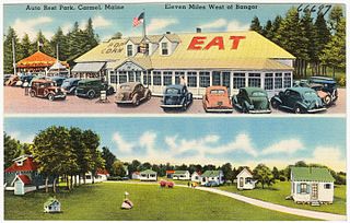
Carmel is a town in Penobscot County, Maine, United States. It is part of the Bangor Metropolitan Statistical Area. The population was 2,867 at the 2020 census.

Hermon is a town in Penobscot County, Maine, United States. The population was 6,461 at the 2020 census.

Cornville is a town in Somerset County, Maine, United States. The population was 1,317 at the 2020 census.

<span class="mw-page-title-main">Smithfield, Maine</span> Town in the state of Maine, United States

Smithfield is a town in Somerset County, Maine, United States. The population was 925 at the 2020 census. The town was incorporated on February 29, 1840, making it the only town in Maine incorporated on Leap Day. The town was named after the Rev. Henry Smith, an early settler.

<span class="mw-page-title-main">Burnham, Maine</span> Town in the state of Maine, United States

Burnham is a town in Waldo County, Maine, United States. The population was 1,096 at the 2020 census.

<span class="mw-page-title-main">Thorndike, Maine</span> Town in the state of Maine, United States

Thorndike is a town in Waldo County, Maine, United States. The town was named after Israel Thorndike, a landowner. The population was 774 at the 2020 census.

<span class="mw-page-title-main">Troy, Maine</span> Town in the state of Maine, United States

Troy is a town in Waldo County, Maine, United States. The population was 1,018 at the 2020 census.

Crawford is a town in Washington County, Maine, United States. The town was named after William H. Crawford, Secretary of the Treasury. The population was 93 at the 2020 census.

<span class="mw-page-title-main">St. Albans, Maine</span> Town in the state of Maine, United States

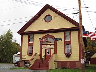
St. Albans is a town in Somerset County, Maine, United States. The population was 2,045 at the 2020 census.

References

  1. 1 2 "US Gazetteer files 2010". United States Census Bureau . Retrieved December 16, 2012.
  2. "Census - Geography Profile: Peru town, Oxford County, Maine" . Retrieved January 20, 2022.
  3. Maine Genealogy: Peru, Oxford County, Maine
  4. Varney, George J. (1886), Gazetteer of the state of Maine. Peru, Boston: Russell
  5. REGIONAL SCHOOL UNITS IN MAINE (PDF)
  6. "Census of Population and Housing". Census.gov. Retrieved June 4, 2015.
  7. "U.S. Census website". United States Census Bureau . Retrieved February 3, 2024.
  8. "U.S. Census website". United States Census Bureau . Retrieved December 16, 2012.
  9. "U.S. Census website". United States Census Bureau . Retrieved January 31, 2008.

44°30′24″N70°24′19″W / 44.50667°N 70.40528°W / 44.50667; -70.40528