Canton, Maine

Last updated

Canton, Maine
Main Street, Canton, ME.jpg
Main Street in 1909
USA Maine location map.svg
Red pog.svg
Canton, Maine
Location within the state of Maine
Coordinates: 44°27′26″N70°18′15″W / 44.45722°N 70.30417°W / 44.45722; -70.30417
CountryUnited States
State Maine
County Oxford
Incorporated1821
Area
[1]
  Total30.50 sq mi (78.99 km2)
  Land29.12 sq mi (75.42 km2)
  Water1.38 sq mi (3.57 km2)
Elevation
400 ft (122 m)
Population
 (2020)
  Total1,125
  Density39/sq mi (14.9/km2)
Time zone UTC-5 (Eastern (EST))
  Summer (DST) UTC-4 (EDT)
ZIP code
04221
Area code 207
FIPS code 23-10005
GNIS feature ID0582386
Website www.cantonmaine.org

Canton is a town in Oxford County, Maine, United States. Canton is included in the Lewiston-Auburn, Maine metropolitan New England city and town area. The population was 1,125 at the 2020 census. [2] Located beside Lake Anasagunticook, Canton is a summer recreational area.

Contents

History

Canton Point was the site of Rockemeka, village of the Anasagunticook (or Androscoggin) Abenaki Indians. It is said the tribe had 500 acres (2.0 km2) cleared to raise corn. By 1757 the tribe population was devastated by smallpox.

The land became part of a grant the Massachusetts General Court awarded to Captain Joseph Phipps and 63 other soldiers for their services during the French and Indian War. Called Phipps-Canada, it would be incorporated in 1795 as Jay in honor of John Jay, the first chief justice of the U. S. Supreme Court. On February 5, 1821, Canton was set off from Jay and incorporated, named after Canton, Massachusetts. [3]

Settlement began in the early 1790s when William Livermore, William French, Joseph Coolidge and Alexander Shepherd arrived. Others followed, principally from Massachusetts. The surface of the town is uneven in the outskirts, but smooth and level at Canton Point, where the soil was considered unsurpassed in the state for agriculture. The outlet of Lake Anasagunticook provided water power for industry. Gustavus Hayford settled here in 1814. In addition to a log cabin, he built a sawmill and gristmill. First called Hayford Mills, it would be renamed Canton Mills, and now Canton. In the 19th century, it had a machine shop to manufacture farm implements, a tinware factory and an iron foundry. [4] It remains the business center. The Rumford Branch of the Maine Central Railroad passed through the town in the late 1850s, carrying freight but also tourists. The community developed as a resort area for camping. [5]

In December 2005 the town began a project to relocate the town center and about 60 homes on the floodplains surrounding the Androscoggin River due to frequent spring flooding. Proposals have been floated to replace the vacated lots with parkland or nature trails.

Geography

Lake Anasagunticook in 1911 Lake Anasagunticook, Canton, ME.jpg
Lake Anasagunticook in 1911

According to the United States Census Bureau, the town has a total area of 30.50 square miles (78.99 km2), of which 29.12 square miles (75.42 km2) is land and 1.38 square miles (3.57 km2) is water. [1] Situated beside Lake Anasagunticook, Canton is drained by Whitney Brook and the Androscoggin River.

The town is served by state routes 108 and 140. It borders the towns of Jay to the northeast, Hartford to the south, Peru to the west, and Dixfield to the northwest.

Demographics

Historical population
CensusPop.Note
1830 746
1840 91923.2%
1850 9260.8%
1860 1,02510.7%
1870 984−4.0%
1880 1,0294.6%
1890 1,30326.6%
1900 946−27.4%
1910 1,0137.1%
1920 750−26.0%
1930 7672.3%
1940 706−8.0%
1950 7465.7%
1960 728−2.4%
1970 7421.9%
1980 83112.0%
1990 95114.4%
2000 1,12117.9%
2010 990−11.7%
2020 1,12513.6%
U.S. Decennial Census [6]
Canton Historical Society CantonME HistoricalSociety.jpg
Canton Historical Society

2010 census

As of the census [7] of 2010, there were 990 people, 410 households, and 239 families living in the town. The population density was 34.0 inhabitants per square mile (13.1/km2). There were 473 housing units at an average density of 16.2 per square mile (6.3/km2). The racial makeup of the town was 97.3% White, 0.2% African American, 0.2% Native American, 0.2% Asian, 0.2% from other races, and 1.9% from two or more races. Hispanic or Latino of any race were 1.0% of the population.

There were 410 households, of which 22.2% had children under the age of 18 living with them, 44.1% were married couples living together, 8.5% had a female householder with no husband present, 5.6% had a male householder with no wife present, and 41.7% were non-families. 27.8% of all households were made up of individuals, and 9.2% had someone living alone who was 65 years of age or older. The average household size was 2.30 and the average family size was 2.83.

The median age in the town was 48 years. 17.2% of residents were under the age of 18; 7.1% were between the ages of 18 and 24; 20.2% were from 25 to 44; 33.7% were from 45 to 64; and 21.8% were 65 years of age or older. The gender makeup of the town was 47.9% male and 52.1% female.

2000 census

As of the census [8] of 2000, there were 1,121 people, 400 households, and 273 families living in the town. The population density was 38.7 inhabitants per square mile (14.9/km2). There were 476 housing units at an average density of 16.4 per square mile (6.3/km2). The racial makeup of the town was 99.11% White, 0.09% African American, 0.18% Native American, 0.54% Asian, and 0.09% from two or more races. Hispanic or Latino of any race were 0.80% of the population.

There were 400 households, out of which 33.3% had children under the age of 18 living with them, 52.0% were married couples living together, 12.0% had a female householder with no husband present, and 31.8% were non-families. 25.0% of all households were made up of individuals, and 10.5% had someone living alone who was 65 years of age or older. The average household size was 2.54 and the average family size was 3.06.

In the town, the population was spread out, with 23.9% under the age of 18, 5.5% from 18 to 24, 30.3% from 25 to 44, 21.6% from 45 to 64, and 18.6% who were 65 years of age or older. The median age was 40 years. For every 100 females, there were 92.6 males. For every 100 females age 18 and over, there were 97.5 males.

The median income for a household in the town was $32,625, and the median income for a family was $40,469. Males had a median income of $31,607 versus $21,094 for females. The per capita income for the town was $14,065. About 14.0% of families and 19.4% of the population were below the poverty line, including 23.9% of those under age 18 and 22.5% of those age 65 or over.

Sites of interest

Notable people

Related Research Articles

<span class="mw-page-title-main">Greene, Maine</span> Town in the state of Maine, United States

Greene is a town in Androscoggin County, Maine, United States. The population was 4,376 at the 2020 census. It is included in both the Lewiston-Auburn, Maine metropolitan statistical area and the Lewiston-Auburn, Maine Metropolitan New England city and town area. The central village in the town comprises the Greene census-designated place.

<span class="mw-page-title-main">Lisbon, Maine</span> Town in the state of Maine, United States

Lisbon is a town in Androscoggin County, Maine, United States. The population was 9,711 at the 2020 census. It is included in both the Lewiston-Auburn, Maine metropolitan statistical area and the Lewiston–Auburn, Maine Metropolitan New England city and town area. The town of Lisbon includes the villages of Lisbon and Lisbon Falls.

<span class="mw-page-title-main">Lisbon Falls, Maine</span> Census-designated place in Maine, United States

Lisbon Falls is a census-designated place (CDP) in the town of Lisbon, located in Androscoggin County, Maine, United States. The population of Lisbon Falls was 4,100 at the 2010 census. It is included in both the Lewiston-Auburn, Maine metropolitan statistical area and the Lewiston-Auburn, Maine, Metropolitan New England city and town area.

<span class="mw-page-title-main">Livermore, Maine</span> Town in the state of Maine, United States

Livermore is a town in Androscoggin County, Maine, United States, formerly in Oxford County, Maine. The population was 2,127 at the 2020 United States Census. It is included in both the Lewiston-Auburn, Maine Metropolitan Statistical Area and the Lewiston-Auburn, Maine Metropolitan New England City and Town Area. High schools students from Livermore attend Spruce Mountain High School in neighboring Livermore Falls. Livermore is known for The Norlands, the Washburn family home.

<span class="mw-page-title-main">Minot, Maine</span> Town in the state of Maine, United States

Minot is a town in Androscoggin County, Maine, United States. The population was 2,766 at the 2020 census. The town includes the villages of West Minot and Minot Center. It is part of both the Lewiston-Auburn, Maine metropolitan statistical area and the Lewiston-Auburn, Maine metropolitan New England city and town area.

<span class="mw-page-title-main">Sabattus, Maine</span> Town in the state of Maine, United States

Sabattus is a town in Androscoggin County, Maine, United States. The population was 5,044 at the 2020 census. It is included in both the Lewiston-Auburn, Maine Metropolitan Statistical Area and the Lewiston-Auburn, Maine Metropolitan New England City and Town Area. The town was formerly known as "Webster", and changed its name to "Sabattus" in 1971, in honor of a former Anasagunticook Indian chief. The village of Sabattus is in the northwestern corner of the town, at the outlet of Sabattus Pond.

<span class="mw-page-title-main">Turner, Maine</span> Town in the state of Maine, United States

Turner is a town in Androscoggin County, Maine, United States. The population was 5,817 at the 2020 census. The town includes the villages of Turner, Turner Center and North Turner. The town is part of the Lewiston-Auburn, Maine Metropolitan New England City and Town Area.

<span class="mw-page-title-main">Wales, Maine</span> Town in the state of Maine, United States

Wales is a town in Androscoggin County, Maine, United States. The population was 1,608 at the 2020 census. It is included in both the Lewiston-Auburn, Maine Metropolitan Statistical Area and the Lewiston-Auburn, Maine Metropolitan New England City and Town Area.

<span class="mw-page-title-main">Carthage, Maine</span> Town in the state of Maine, United States

Carthage is a town in Franklin County, Maine, United States. The population was 509 at the 2020 census.

<span class="mw-page-title-main">Jay, Maine</span> Town in the state of Maine, United States

Jay is a town in Franklin County, Maine, United States. Jay was included in the Lewiston-Auburn, Maine metropolitan New England city and town area. The population was 4,620 at the 2020 United States Census. Jay includes the village of Chisholm.

<span class="mw-page-title-main">Buckfield, Maine</span> Town in Maine, United States

Buckfield is a town in Oxford County, Maine, United States. Buckfield is included in the Lewiston-Auburn, Maine metropolitan New England City and Town Area. It is a member of Regional School Unit 10 along with nearby Hartford and Sumner. The town had a population of 1,983 as of the 2020 census.

<span class="mw-page-title-main">Paris, Maine</span> Town in Maine, United States

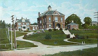
Paris is a town in and the county seat of Oxford County, Maine, United States. Paris is included in the Lewiston-Auburn, Maine metropolitan New England City and town area. The population was 5,179 at the 2020 census. The census-designated place of South Paris is located within the town. Because the U.S. Post Office refers to the entire town as South Paris, the town as a whole is commonly referred to as South Paris. The main exception is the area known as Paris Hill, which is a scenic historic district popular with tourists. On May 30, 2019, the town declared itself to be a second amendment sanctuary.

<span class="mw-page-title-main">South Paris, Maine</span> CDP in Maine, United States

South Paris is a census-designated place (CDP) located within the town of Paris in Oxford County, Maine, United States. South Paris is included in the Lewiston-Auburn, Maine metropolitan New England city and town area.The population was 2,237 at the 2000 census. While the CDP refers only to the densely settled area in the southern part of the town of Paris, the entire town, outside of Paris Hill, is located within the South Paris ZIP code, resulting in many residents referring to the entire town as South Paris.

<span class="mw-page-title-main">Errol, New Hampshire</span> Town in New Hampshire, United States

Errol is a town in Coös County, New Hampshire, United States. The population was 298 at the 2020 census. It is located north of the White Mountains along Route 16 at its intersection of Route 26. It has a municipal airport with a single, unpaved runway.

<span class="mw-page-title-main">Livermore Falls, Maine</span> Town in the state of Maine, United States

Livermore Falls is a town in Androscoggin County, Maine, United States. The population was 3,060 at the 2020 census. It is included in both the Lewiston-Auburn, Maine Metropolitan Statistical Area and the Lewiston-Auburn, Maine Metropolitan New England City and Town Area. High school students in Livermore Falls attend Spruce Mountain High School.

<span class="mw-page-title-main">Mechanic Falls, Maine</span> Town in the state of Maine, United States

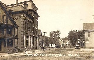
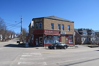
Mechanic Falls is a town in Androscoggin County, Maine, United States. The population was 3,107 at the 2020 census. It is included in both the Lewiston-Auburn, Maine metropolitan statistical area and the Lewiston-Auburn, Maine metropolitan New England city and town area.

<span class="mw-page-title-main">Dixfield, Maine</span> Town in the state of Maine, United States

Dixfield is a town in Oxford County, Maine, United States. Dixfield is included in the Lewiston-Auburn, Maine metropolitan New England city and town area. The population was 2,253 at the 2020 census. The town motto of Dixfield is "The Only One", because it is the only town in the world to claim that name. Dr. Elijeh Dix, a substantial landowner in the area, bought the town which bears his name.

<span class="mw-page-title-main">Mexico, Maine</span> Town in the state of Maine, United States

Mexico, near Rumford, is a town in Oxford County, Maine, United States. Mexico is included in the Lewiston-Auburn, Maine metropolitan New England city and town area. The population was 2,756 at the 2020 census. Mexico is a small mill town for the papermaking industry.

<span class="mw-page-title-main">Oxford, Maine</span> Town in the state of Maine, United States

Oxford is a town in Oxford County, Maine, United States. Oxford is included in the Lewiston-Auburn, Maine metropolitan New England city and town area. The population was 4,229 at the 2020 census. Oxford is home to the Oxford Plains Speedway, Kamp Kohut, the annual Oxford County Fair, and Oxford Casino. The town includes the village of Welchville.

<span class="mw-page-title-main">Topsham, Maine</span> Town in the state of Maine, United States

Topsham is a town in Sagadahoc County, Maine, United States. Topsham was included in the Lewiston-Auburn, Maine metropolitan New England city and town area. The population was 9,560 at the 2020 census. It is part of the Portland–South Portland–Biddeford, Maine metropolitan statistical area. The town is home to the annual Topsham Fair.

References

  1. 1 2 "US Gazetteer files 2010". United States Census Bureau . Retrieved December 16, 2012.
  2. "Census - Geography Profile: Canton town, Oxford County, Maine" . Retrieved January 22, 2022.
  3. Coolidge, Austin J.; John B. Mansfield (1859). A History and Description of New England. Boston, Massachusetts: A.J. Coolidge. pp.  84–85. coolidge mansfield history description new england 1859.
  4. Varney, George J. (1886), Gazetteer of the state of Maine. Canton, Boston: Russell[ permanent dead link ]
  5. Historical Sketch of Canton, Maine (1889) [ permanent dead link ]
  6. "Census of Population and Housing". Census.gov. Retrieved June 4, 2015.
  7. "U.S. Census website". United States Census Bureau . Retrieved December 16, 2012.
  8. "U.S. Census website". United States Census Bureau . Retrieved January 31, 2008.

Further reading

44°26′26″N70°18′55″W / 44.44056°N 70.31528°W / 44.44056; -70.31528