
The St. Francois Mountains in southeast Missouri are a mountain range of Precambrian igneous mountains rising over the Ozark Plateau. This range is one of the oldest exposures of igneous rock in North America. The name of the range is spelled out as Saint Francois Mountains in official GNIS sources, but it is sometimes misspelled in use as St. Francis Mountains to match the anglicized pronunciation of both the range and St. Francois County.

Great Smoky Mountains National Park is an American national park and a UNESCO World Heritage Site that straddles the ridgeline of the Great Smoky Mountains, part of the Blue Ridge Mountains, which are a division of the larger Appalachian Mountain chain. The border between Tennessee and North Carolina runs northeast to southwest through the centerline of the park. Great Smoky Mountains is the most visited national park in the United States with over 11.3 million recreational visitors in 2016. The Appalachian Trail passes through the center of the park on its route from Maine to Georgia. The park was chartered by the United States Congress in 1934 and officially dedicated by President Franklin D. Roosevelt in 1940.

The Blue Ridge Mountains are a physiographic province of the larger Appalachian Mountains range. The mountain range is located in the eastern United States, and extends 550 miles southwest from southern Pennsylvania through Maryland, West Virginia, Virginia, North Carolina, South Carolina, Tennessee and Georgia. This province consists of northern and southern physiographic regions, which divide near the Roanoke River gap. To the west of the Blue Ridge, between it and the bulk of the Appalachians, lies the Great Appalachian Valley, bordered on the west by the Ridge and Valley province of the Appalachian range.

The Uinta Mountains are an east-west trending chain of mountains in northeastern Utah extending slightly into southern Wyoming in the United States. As a subrange of the Rocky Mountains, they are unusual for being the highest range in the contiguous United States running east to west, and lie approximately 100 miles (160 km) east of Salt Lake City. The range has peaks ranging from 11,000–13,528 feet (3,353–4,123 m), with the highest point being Kings Peak, also the highest point in Utah. The Mirror Lake Highway crosses the western half of the Uintas on its way to Wyoming.
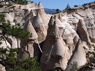
Kasha-Katuwe Tent Rocks National Monument is a U.S. National Monument located approximately 40 miles southwest of Santa Fe, New Mexico, near Cochiti Pueblo. Managed by the Bureau of Land Management (BLM), it was established as a U.S. National Monument by President Bill Clinton in January 2001. Kasha-Katuwe means "white cliffs" in the Pueblo language Keresan. The monument is a unit of the BLM's National Conservation Lands.

The Champlain Valley is a region of the United States around Lake Champlain in Vermont and New York extending north slightly into Quebec, Canada. It is part of the St. Lawrence River drainage basin, drained northward by the Richelieu River into the St. Lawrence at Sorel-Tracy, Quebec. The Richelieu valley is not generally referred to as part of the Champlain Valley.

Goat Rocks is an extinct stratovolcano in the Cascade Range, located between Mount Rainier and Mount Adams in southern Washington, in the United States. Part of the Cascade Volcanoes, it was formed by the subduction of the Juan de Fuca Plate under the western edge of the North American Plate. The volcano was active from 3.2 million years ago until eruptions ceased between 1 and 0.5 million years ago. Throughout its complex eruptive history, volcanism shifted from silicic explosive eruptions to voluminous, mafic activity.
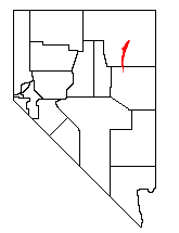
The Ruby Mountains are a mountain range, primarily located within Elko County with a small extension into White Pine County, in Nevada, United States. Most of the range is included within the Humboldt-Toiyabe National Forest. The range reaches a maximum elevation of 11,387 feet (3,471 m) on the summit of Ruby Dome. To the north is Secret Pass and the East Humboldt Range, and from there the Rubies run south-southwest for about 80 miles (130 km). To the east lies Ruby Valley, and to the west lie Huntington and Lamoille Valleys. The Ruby Mountains are the only known range of an introduced bird, the Himalayan snowcock, in North America.

South West Rocks is located on the Mid North Coast of New South Wales, Australia, near the mouth of the Macleay River. It is approximately 40 km (25 mi) from Kempsey. Jerseyville is located nearby.

Mill Creek Mountain is a continuous mountain ridge that runs northeast through Hampshire and Hardy counties in the Eastern Panhandle region of the U.S. state of West Virginia. Rising to its greatest elevation of 2,650 feet (808 m) at High Knob, Mill Creek is a folded mountain ridge, belonging to the Ridge-and-Valley Appalachians. Mill Creek Mountain forms the western edge of the South Branch Potomac River Valley and is named for Mill Creek that carves through it at Mechanicsburg Gap allowing the Northwestern Turnpike to pass through as well. Along with Sawmill Ridge, Mill Creek Mountain forms the Trough along the South Branch.

The Turtle Mountains, are located in northeastern San Bernardino County, in the southeastern part of California.

The Lewis Range is a mountain range located in the Rocky Mountains of northern Montana, United States and extreme southern Alberta, Canada. It was formed as a result of the Lewis Overthrust, a geologic thrust fault resulted in the overlying of younger Cretaceous rocks by older Proterozoic rocks. The range is located within Waterton Lakes National Park in Alberta, Canada and Glacier National Park and the Bob Marshall Wilderness Complex in Montana, United States. The highest peak is Mount Cleveland at 10,466 ft (3,190 m).

Spruce Knob-Seneca Rocks National Recreation Area is a U.S. National Recreation Area (NRA) located within the Monongahela National Forest of eastern West Virginia, USA.

Seneca Creek is a 19.6-mile-long (31.5 km) tributary of the North Fork of the South Branch of the Potomac River located entirely within Pendleton County, West Virginia, USA.

The Geology of Pennsylvania consists of six distinct physiographic provinces, three of which are subdivided into different sections. Each province has its own economic advantages and geologic hazards and plays an important role in shaping everyday life in the state. They are: the Atlantic Coastal Plain Province, the Piedmont Province, the New England Province, the Ridge and Valley Province, the Appalachian Plateau Province, and the Central Lowlands Province.
White Rock, 2,550 feet (780 m), is the high point on a 7 mi (11 km) ridgeline in the Taconic Mountains. The ridge is located in the tri-state corner of New York, Massachusetts, and Vermont in the towns of Petersburgh, Williamstown, and Pownal. The ridge has several distinct knobs; those with names are, from south to north: White Rocks, 2,365 feet (721 m); Smith Hill, 2,330 feet (710 m); White Rock, the high point 2,550 feet (780 m); and Bald Mountain 2,485 feet (757 m). The Snow Hole, located along the ridgeline between Bald Mountain and the White Rock, is a crevasse in which snow can be found well into the summer.

The Riverside Mountains are a mountain range in Riverside County, California. The town of Vidal, California is located in the West Riverside Mountains.
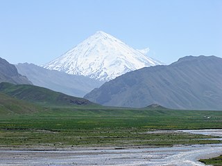
The Alborz, also spelled as Alburz, Elburz or Elborz, is a mountain range in northern Iran that stretches from the border of Azerbaijan along the western and entire southern coast of the Caspian Sea and finally runs northeast and merges into the Aladagh Mountains in the northern parts of Khorasan. This mountain range is divided into Western, Central, and Eastern Alborz Mountains. The Western Alborz Range runs south-southeastward almost along the western coast of the Caspian Sea. The Central Alborz runs from west to east along the entire southern coast of the Caspian Sea, while the Eastern Alborz runs in a northeasterly direction towards the northern parts of the Khorasan region southeast of the Caspian Sea. Mount Damavand, the highest mountain in Iran measuring 5,610.0 m, is located in the Central Alborz Mountains.

Mount Morrison is a foothill on the eastern flank of the Front Range of the Rocky Mountains of North America. The 7,881-foot (2,402 m) peak is located in Red Rocks Park, 1.9 miles (3.0 km) northwest by west of the Town of Morrison in Jefferson County, Colorado, United States. Red Rocks Amphitheatre is located on the eastern side of the mountain.
High Rock Mountain is a mountain in Warren County, New Jersey. The summit rises to 889 feet (271 m), and is located on the boundary of Liberty and White Townships. It is part of the New York–New Jersey Highlands of the Appalachian Mountains, although somewhat isolated to the west of the main body of the Highlands.


