
The Appalachian Mountains, often called the Appalachians, are a system of mountains in eastern to northeastern North America. The Appalachians first formed roughly 480 million years ago during the Ordovician Period. They once reached elevations similar to those of the Alps and the Rocky Mountains before experiencing natural erosion. The Appalachian chain is a barrier to east–west travel, as it forms a series of alternating ridgelines and valleys oriented in opposition to most highways and railroads running east–west.
The geology of the Appalachians dates back to more than 480 million years ago. A look at rocks exposed in today's Appalachian Mountains reveals elongate belts of folded and thrust faulted marine sedimentary rocks, volcanic rocks and slivers of ancient ocean floor – strong evidence that these rocks were deformed during plate collision. The birth of the Appalachian ranges marks the first of several mountain building plate collisions that culminated in the construction of the supercontinent Pangaea with the Appalachians and neighboring Anti-Atlas mountains near the center. These mountain ranges likely once reached elevations similar to those of the Alps and the Rocky Mountains before they were eroded.

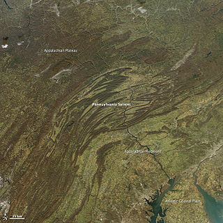
The Great Appalachian Valley, also called The Great Valley or Great Valley Region, is one of the major landform features of eastern North America. It is a gigantic trough—a chain of valley lowlands—and the central feature of the Appalachian Mountain system. The trough stretches about 1,200 miles (1,900 km) from Quebec to Alabama and has been an important north-south route of travel since prehistoric times.
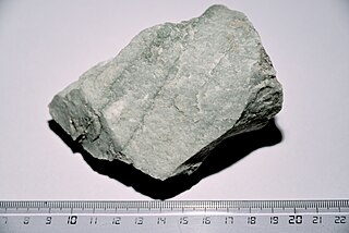
Quartzite is a hard, non-foliated metamorphic rock which was originally pure quartz sandstone. Sandstone is converted into quartzite through heating and pressure usually related to tectonic compression within orogenic belts. Pure quartzite is usually white to grey, though quartzites often occur in various shades of pink and red due to varying amounts of hematite. Other colors, such as yellow, green, blue and orange, are due to other minerals.

The Blue Ridge Mountains are a physiographic province of the larger Appalachian Mountains range. The mountain range is located in the eastern United States, and extends 550 miles southwest from southern Pennsylvania through Maryland, West Virginia, Virginia, North Carolina, South Carolina, Tennessee, and Georgia. This province consists of northern and southern physiographic regions, which divide near the Roanoke River gap. To the west of the Blue Ridge, between it and the bulk of the Appalachians, lies the Great Appalachian Valley, bordered on the west by the Ridge and Valley province of the Appalachian range.

The Alleghanian orogeny or Appalachian orogeny is one of the geological mountain-forming events that formed the Appalachian Mountains and Allegheny Mountains. The term and spelling Alleghany orogeny was originally proposed by H.P. Woodward in 1957.

The Taconic orogeny was a mountain building period that ended 440 million years ago and affected most of modern-day New England. A great mountain chain formed from eastern Canada down through what is now the Piedmont of the East coast of the United States. As the mountain chain eroded in the Silurian and Devonian periods, sediments from the mountain chain spread throughout the present-day Appalachians and midcontinental North America.

The Hudson Highlands are mountains on both sides of the Hudson River in New York state lying primarily in Putnam County on its east bank and Orange County on its west. They continue somewhat to the south in Westchester County and Rockland County, respectively.

South Mountain is a colloquial name applied to an Appalachian Mountain range extending north and northeast along the south side of Lebanon Valley to the Lehigh Valley region of Pennsylvania in the United States.

The geology of Georgia consists of four distinct geologic regions, beginning in the northwest corner of the state and moving through the state to the southeast: the Valley and Ridge region, also known as the Appalachian Plateau; the Blue Ridge; the Piedmont and the Coastal Plain. The Fall Line is the boundary between the Piedmont and the Coastal Plain.

The Geology of Pennsylvania consists of six distinct physiographic provinces, three of which are subdivided into different sections. Each province has its own economic advantages and geologic hazards and plays an important role in shaping everyday life in the state. They are: the Atlantic Coastal Plain Province, the Piedmont Province, the New England Province, the Ridge and Valley Province, the Appalachian Plateau Province, and the Central Lowlands Province.
New Jersey is a very geologically and geographically diverse region in the United States' Middle Atlantic region, offering variety from the Appalachian Mountains and the Highlands in the state's northwest, to the Atlantic Coastal Plain region that encompasses both the Pine Barrens and the Jersey Shore. The state's geological features have impacted the course of settlement, development, commerce and industry over the past four centuries.

Pochuck Mountain is a ridge in the New York-New Jersey Highlands region of the Appalachian Mountains. Pochuck Mountain's summit and most of its peaks lie within Vernon Township, Sussex County, New Jersey, although the south-western portion of the ridge lies within Hardyston Township, and the north-eastern tip of the ridge extends over the New York state line into Orange County. The ridge marks the eastern edge of the Great Appalachian Valley, and it divides the watersheds of the Wallkill River and its tributary Pochuck Creek. The two rivers meet at Pochuck Neck, marking the terminus of the ridge.
The Reading Prong is a physiographic subprovince of the New England Uplands section of the New England province of the Appalachian Highlands. The prong consists of mountains made up of crystalline metamorphic rock.

The Ramapo Fault zone is a system of faults between the northern Appalachian Mountains and Piedmont areas to the east. Spanning more than 185 miles (298 km) in New York, New Jersey, and Pennsylvania, it is perhaps the best known fault zone in the Mid-Atlantic region, and some small earthquakes have been known to occur in its vicinity. Recently, public knowledge about the fault has increased, especially after the 1970s, when the fault's proximity to the Indian Point nuclear plant in New York was noted.
The Hamburg Mountains are a range of the New York-New Jersey Highlands region of the Appalachian Mountains. The summit, reaching a height of 1,473 feet (449 m), lies within Sussex County, New Jersey.
The Pimple Hills are a range of the New York-New Jersey Highlands region of the Appalachian Mountains. The summit, reaching a height of 1,122 feet (342 m), lies within Sussex County, New Jersey.
The Sparta Mountains are a range of the New York-New Jersey Highlands region of the Appalachian Mountains. The summit, reaching a height of 1,230 feet, lies within Sussex County, New Jersey.

The geology of New York State is made up of ancient Precambrian crystalline basement rock, forming the Adirondack Mountains and the bedrock of much of the state. These rocks experienced numerous deformations during mountain building events and much of the region was flooded by shallow seas depositing thick sequences of sedimentary rock during the Paleozoic. Fewer rocks have deposited since the Mesozoic as several kilometers of rock have eroded into the continental shelf and Atlantic coastal plain, although volcanic and sedimentary rocks in the Newark Basin are a prominent fossil-bearing feature near New York City from the Mesozoic rifting of the supercontinent Pangea.
The geology of North Carolina includes ancient Proterozoic rocks belonging to the Grenville Province in the Blue Ridge. The region experienced igneous activity and the addition of new terranes and orogeny mountain building events throughout the Paleozoic, followed by the rifting of the Atlantic Ocean and the deposition of thick sediments in the Coastal Plain and offshore waters.
