Hinton, Alberta

Last updated

Hinton
Town
Town of Hinton
Hinton Govt Centre.jpg
Government Centre
Hinton Alberta logo.svg
Motto: 
Gateway to the Rockies
0151 Town Hinton, Alberta Locator.svg
Location in Yellowhead County
Alberta County Point Locator.svg
Red pog.svg
Hinton
Location of Hinton in Alberta
Coordinates: 53°24′40″N117°33′46″W / 53.41111°N 117.56278°W / 53.41111; -117.56278 [1]
CountryCanada
Province Alberta
Planning region Upper Athabasca
Municipal district Yellowhead County
Founded1928
Incorporated [3]  
   New town November 1, 1956
   Town December 29, 1958
Amalgamated [4] April 1, 1957
Government
[5]
  MayorNicholas Nissen
  Governing body
Hinton Town Council
  • Ryan Maguhn
  • Albert Ostashek
  • JoAnn Race
  • Trevor Haas
  • Stuart Taylor
  • Brian Laberge
  ManagerJordan Panasiuk
   MP Gerald Soroka (CPC - Yellowhead)
   MLA Martin Long (UCP - West Yellowhead)
Area
 (2021) [6]
  Land33.32 km2 (12.86 sq mi)
Elevation
[7]
990 m (3,250 ft)
Population
 (2021) [6] [8]
  Total9,817
  Density294.6/km2 (763/sq mi)
  Estimate (2022)
10,087 [9]
Time zone UTC−07:00 (MST)
  Summer (DST) UTC−06:00 (MDT)
Forward sortation area
T7V
Area code(s) 780 / 587
Highways Alberta Highway 16.svg Hwy 16 (TCH) Yellowhead Highway
Alberta Highway 40.svg Hwy 40
Website Official website

Hinton is a town in west-central Alberta, Canada.

It is located in Yellowhead County, 81 km (50 mi) northeast of Jasper and about 284 km (176 mi) west of Alberta's capital city, Edmonton, at the intersection of Yellowhead and Bighorn Highway, in the Athabasca River valley.

Contents

Geography

Hinton lies in the Alberta Plateau Benchlands physiographic subdivision of the Interior Plains. Soils around town are influenced by deposits of carbonate-rich, wind-blown sand and silt which usually have surface textures of loam, sandy loam or silt loam. They are moderately alkaline, in contrast to the varying, mostly moderate acidity which prevails beyond the zone of calcareous aeolian material. [10]

Climate

The closest weather station is located at Entrance, about 10 km (6.2 mi) southwest of Hinton

Climate data for Entrance
Climate ID: 3062440; coordinates 53°22′N117°42′W / 53.367°N 117.700°W / 53.367; -117.700 (Fort Chipewyan Airport) ; elevation: 990.6 m (3,250 ft); 1981–2010 normals, extremes 1917-2006
MonthJanFebMarAprMayJunJulAugSepOctNovDecYear
Record high °C (°F)22.2
(72.0)
19.0
(66.2)
22.0
(71.6)
27.8
(82.0)
33.9
(93.0)
34.4
(93.9)
37.8
(100.0)
34.4
(93.9)
34.0
(93.2)
29.4
(84.9)
21.1
(70.0)
17.8
(64.0)
37.8
(100.0)
Mean daily maximum °C (°F)−3.3
(26.1)
1.1
(34.0)
5.1
(41.2)
11.5
(52.7)
16.3
(61.3)
20.0
(68.0)
22.2
(72.0)
21.7
(71.1)
17.1
(62.8)
10.4
(50.7)
1.8
(35.2)
−1.3
(29.7)
10.2
(50.4)
Daily mean °C (°F)−9.2
(15.4)
−5.9
(21.4)
−2.2
(28.0)
3.9
(39.0)
8.4
(47.1)
12.3
(54.1)
14.4
(57.9)
13.6
(56.5)
9.2
(48.6)
3.9
(39.0)
−3.7
(25.3)
−7.0
(19.4)
3.1
(37.6)
Mean daily minimum °C (°F)−15.0
(5.0)
−12.8
(9.0)
−9.5
(14.9)
−3.7
(25.3)
0.6
(33.1)
4.6
(40.3)
6.6
(43.9)
5.5
(41.9)
1.3
(34.3)
−2.7
(27.1)
−9.3
(15.3)
−12.6
(9.3)
−3.9
(25.0)
Record low °C (°F)−51.2
(−60.2)
−47.0
(−52.6)
−42.8
(−45.0)
−35.6
(−32.1)
−13.5
(7.7)
−6.7
(19.9)
−2.8
(27.0)
−5.0
(23.0)
−19.4
(−2.9)
−27.0
(−16.6)
−39.0
(−38.2)
−47.2
(−53.0)
−51.2
(−60.2)
Average precipitation mm (inches)24.3
(0.96)
12.9
(0.51)
22.1
(0.87)
25.9
(1.02)
62.5
(2.46)
76.3
(3.00)
94.0
(3.70)
73.9
(2.91)
46.3
(1.82)
33.1
(1.30)
22.1
(0.87)
14.4
(0.57)
507.9
(20.00)
Average rainfall mm (inches)0.8
(0.03)
0.4
(0.02)
1.6
(0.06)
17.3
(0.68)
56.5
(2.22)
76.3
(3.00)
94.0
(3.70)
73.9
(2.91)
44.6
(1.76)
19.0
(0.75)
2.4
(0.09)
0.3
(0.01)
387.0
(15.24)
Average snowfall cm (inches)23.5
(9.3)
12.5
(4.9)
20.5
(8.1)
8.6
(3.4)
6.0
(2.4)
0.0
(0.0)
0.0
(0.0)
0.1
(0.0)
1.6
(0.6)
14.2
(5.6)
19.7
(7.8)
14.2
(5.6)
120.9
(47.6)
Average precipitation days (≥ 0.2 mm)5.84.26.56.611.313.012.612.811.16.45.94.7100.9
Average rainy days (≥ 0.2 mm)0.40.10.64.210.813.012.612.810.94.60.90.170.9
Average snowy days (≥ 0.2 cm)5.54.16.13.01.30.00.00.00.52.75.34.633.0
Source: Environment and Climate Change Canada [11]

History

Bob Nystrom, Swedish-Canadian professional ice hockey player, moved to Hinton as a 4-year old Bob Nystrom 1973.jpg
Bob Nystrom, Swedish-Canadian professional ice hockey player, moved to Hinton as a 4-year old
Looking west from Hinton on the Yellowhead Highway Hinton Alberta looking west Trans-Canada highway.jpg
Looking west from Hinton on the Yellowhead Highway
Downtown Hinton Hinton downtown.JPG
Downtown Hinton

The Town of Hinton was named for William P. Hinton, Vice President and General Manager of the Grand Trunk Pacific Railway. The community was named in 1911 and remained a hamlet for the next 45 years.

Settlement in the area was scattered along a line some 12 km (7.5 mi) in length. A site along Hardisty Creek is where a First Nations group from the Jasper area had left members stricken with smallpox while the rest of the group travelled to Lac Ste. Anne to find medical aid for the smallpox epidemic which was ravaging the indigenous population. The area was thus dubbed Cache Picote (Smallpox Camp) in 1870.

In 1888, Jack Gregg established a trading post at Prairie Creek to serve travellers along the Jasper trail. The creek is now known as Muskuta Creek after an incorrect interpretation of the Cree name by white settlers. The construction of the Grand Trunk Pacific Railway saw the establishment of a construction camp at the mouth of Prairie Creek (at the Athabasca River) in 1908. A trestle was built over the creek and is still in use by the Canadian National Railway (CNR) today.

In 1911 the Grand Trunk Pacific built a station house at mile 978 west of Winnipeg. The station was named Hinton, and the community was born.

The Canadian Northern Railway also established a station called Bliss in 1914. The Canadian Northern Railway ran north of the Grand Trunk Pacific line and the Bliss station was about 6.4 km (4 mi) east of Hinton in the Athabasca River valley. In 1916 when the Grand Trunk Pacific rail line was temporarily closed, Dalehurst became the postal station for Hinton. Entrance (formerly Dyke), another important centre to Hinton, served as its communications centre. The original community known as Entrance was so named due to its location at the entrance to Jasper Forest Park and was on the Canadian Northern rail line north of the Athabasca River. The original site of Entrance is now known as Old Entrance.

The Canadian National Railway became the owner of both the Canadian Northern and the Grand Trunk Pacific, and various portions of both lines were used by the new railway. The company, however, abandoned the use of the rail line through Bliss in 1926 and once again the rail line through Hinton was opened.

The population of Hinton experienced a boom during the 1930s when American entrepreneur Frank Seabolt and two partners opened the Hinton coal mine in 1931. [12] Shortly thereafter, a recession caused the population to dwindle to fewer than 100 people, but the town began to rebound in 1955 with the construction of a pulp mill. The mill brought rapid growth to Hinton and a new village was developed and was named Drinnan in 1956. The two communities amalgamated on April 1, 1957, to form the present Town of Hinton. [4]

Hinton train collision

On February 8, 1986, a Canadian National Railway freight train collided with a Via Rail passenger train called the Super Continental , killing twenty-three people. The Hinton train collision was the deadliest rail disaster in Canada since the Dugald rail accident of 1947, which had thirty-one fatalities, and was not surpassed until the Lac-Mégantic rail disaster in 2013, which resulted in forty-seven fatalities. It was surmised that the accident was a result of the crew of the freight train becoming incapacitated, and the resulting investigations revealed serious flaws in Canadian National Railway's employee practises. [13]

Demographics

In the 2021 Canadian census conducted by Statistics Canada, the Town of Hinton had a population of 9,817 living in 4,006 of its 4,405 total private dwellings, a change of

In the Canada 2016 Census conducted by Statistics Canada, the Town of Hinton recorded a population of 9,882 living in 3,930 of its 4,343 total private dwellings, a

The population of the Town of Hinton according to its 2009 municipal census is 9,825. [15] The census originally counted 9,812 people within the town limits [16] but an additional 13 were added when a long-standing annexation application was approved shortly after the census was conducted.

It is the site of the Foothills Ojibway Society (non-status First Nation).

Attractions

Hinton is one of two staging areas for expeditions in the Willmore Wilderness Park, the other being Grande Cache.

Nature lovers are drawn to Hinton to visit the Beaver Boardwalk, a 3 km (1.9 mi) walk where they can see beavers and other wildlife. [17]

Infrastructure

Hinton Railway Station Hinton Via 10.jpg
Hinton Railway Station

Transportation

Hinton Transit is the municipal public transportation service, operated under contract by First Student Canada, which is responsible for providing the vehicles, drivers and maintenance. The bus service operates on Monday to Friday from 8:00am to 8:00pm and on Saturday from 8:00am to 6:00pm. No service is provided on Sunday or statutory holidays. [18] There is also an accessible transit service available for residents with physical and cognitive disabilities called The Freedom Express Service. [19]

As a flag stop, Via Rail's The Canadian calls at the Hinton station three times per week, in each direction.

Health care

Emergency and other medical care is provided at the Hinton Healthcare Centre.

Education

Education in Hinton includes: [20]

Media

Newspapers

One weekly newspaper is produced in Hinton; the Hinton Voice, a weekly independent newspaper that started up in June 2009.

Radio

Notable people

See also

Related Research Articles

<span class="mw-page-title-main">Wainwright, Alberta</span> Town in Alberta, Canada

Wainwright is a town in east-central Alberta, Canada. It is approximately 206 kilometres (128 mi) southeast of Edmonton.

<span class="mw-page-title-main">Fort McMurray</span> Place in Alberta, Canada

Fort McMurray is an urban service area in the Regional Municipality of Wood Buffalo in Alberta, Canada. It is located in northeast Alberta, in the middle of the Athabasca oil sands, surrounded by boreal forest. It has played a significant role in the development of the national petroleum industry. The 2016 Fort McMurray wildfire led to the evacuation of its residents and caused widespread damage.

<span class="mw-page-title-main">Spruce Grove</span> City in Alberta, Canada

Spruce Grove is a city that is 11 km (6.8 mi) west of Edmonton, Alberta, in Canada. The city is adjacent to the Town of Stony Plain and is surrounded by Parkland County.

<span class="mw-page-title-main">Banff, Alberta</span> Town in Alberta, Canada

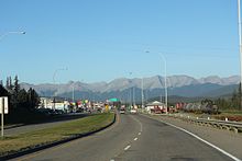
Banff is a town in Banff National Park, Alberta, Canada, in Alberta's Rockies along the Trans-Canada Highway, 126 km (78 mi) west of Calgary and 58 km (36 mi) east of Lake Louise, 1,400 to 1,630 m above sea level,

<span class="mw-page-title-main">Jasper, Alberta</span> Specialized municipality in Alberta, Canada

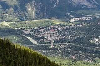
Jasper is a specialized municipality and townsite in western Alberta within the Canadian Rockies. The townsite is in the Athabasca River valley and is the commercial centre of Jasper National Park.

<span class="mw-page-title-main">McBride, British Columbia</span> Village in British Columbia, Canada

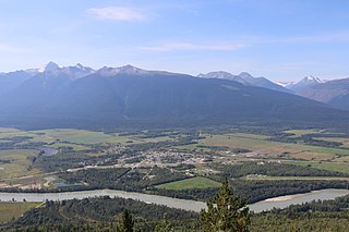
McBride is a village in the Robson Valley region of British Columbia, Canada. The village is located 210 km (130 mi) southeast of Prince George, British Columbia, and 166 km (103 mi) west of Jasper, Alberta. Incorporated in 1932, McBride is located in the Robson Valley surrounded by the Rocky Mountains and Cariboo Ranges.

<span class="mw-page-title-main">Athabasca, Alberta</span> Town in Alberta, Canada

Athabasca, originally named Athabasca Landing, is a town in northern Alberta, Canada. It is located 145 km (90 mi) north of Edmonton at the intersection of Highway 2 and Highway 55, on the banks of the Athabasca River. It is the centre of Athabasca County. It was known as Athabasca Landing prior to August 4, 1913.

<span class="mw-page-title-main">Edson, Alberta</span> Town in Canadian Province of Alberta

Edson is a town in west-central Alberta, Canada. It is located in Yellowhead County, 192 kilometres (119 mi) west of Edmonton along the Yellowhead Highway and 10 kilometres (6.2 mi) east of the intersection with Highway 47.

<span class="mw-page-title-main">Whitecourt</span> Town in Alberta, Canada

Whitecourt is a town in Northern Alberta, Canada that is surrounded by Woodlands County. It is approximately 177 km (110 mi) northwest of Edmonton and 279 km (173 mi) southeast of Grande Prairie at the junction of Highway 43 and Highway 32. It has an elevation of 690 m (2,260 ft).

Alberta Provincial Highway No. 16, commonly referred to as Highway 16, is a major east–west highway in central Alberta, Canada, connecting Jasper to Lloydminster via Edmonton. It forms a portion of the Yellowhead Highway, a major interprovincial route of the Trans-Canada Highway system that stretches from Masset, British Columbia, to Portage la Prairie, Manitoba, near Winnipeg. Highway 16 spans approximately 634 km (394 mi) from Alberta's border with British Columbia in the west to its border with Saskatchewan in the east. As of 2010, all but less than 96 km (60 mi) of the route was divided, with a minimum of two lanes in each direction. It is designated a core route in Canada's National Highway System.

Mundare is a town in central Alberta, Canada. It is approximately 70 km (43 mi) east of Edmonton at the intersection of Highway 15 and Highway 855, 2 km (1.2 mi) north of the Yellowhead Highway. The Canadian National Railway tracks run through the town.

<span class="mw-page-title-main">Hardisty, Alberta</span> Town in Alberta, Canada

Hardisty is a town in Flagstaff County in east-central Alberta, Canada. It is approximately 111 kilometres (69 mi) from the Saskatchewan border, near the crossroads of Highway 13 and Highway 881, in the Battle River Valley. Hardisty is mainly known as a pivotal petroleum industry hub where petroleum products such as Western Canada Select blended crude oil and Hardisty heavy oil are produced and traded.

<span class="mw-page-title-main">Division No. 14, Alberta</span> Census division in Alberta, Canada

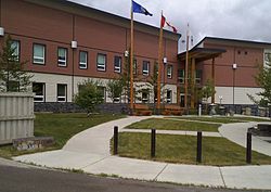
Division No. 14 is a census division in Alberta, Canada. The majority of the division is located in the western portion of central Alberta, while the westernmost portion of the division is located within Alberta's Rockies. The division's largest urban community is the Town of Hinton.

<span class="mw-page-title-main">Tofield</span> Town in Alberta, Canada

Tofield is a town in central Alberta, Canada. It is approximately 68 km (42 mi) east of Edmonton at the junction of Highway 14, Highway 834, and Highway 626. Beaverhill Lake is located immediately northeast of the community.

<span class="mw-page-title-main">Entwistle, Alberta</span> Hamlet in Alberta, Canada

Entwistle is a hamlet in Alberta, Canada, within Parkland County. It is at the Yellowhead Highway's intersection with Highway 22/Highway 16A, approximately 95 kilometres (59 mi) west of Edmonton. It sits on the east banks of the Pembina River near the halfway point between Edmonton and Edson.

<span class="mw-page-title-main">Lac La Biche County</span> Specialized municipality in Alberta, Canada

Lac La Biche County is a specialized municipality within Division No. 12 in northern Alberta, Canada. It was established through the amalgamation of the Town of Lac La Biche and Lakeland County in 2007.

Delacour is a hamlet in southern Alberta under the jurisdiction of Rocky View County. It is located approximately 10 km (6.2 mi) east of the City of Calgary, and 24 km (15 mi) from its downtown. The hamlet features a creek valley setting and a golf club.

<span class="mw-page-title-main">Wildwood, Alberta</span> Hamlet in Alberta, Canada

Wildwood is a hamlet in west-central Alberta, Canada within Yellowhead County. It is on the Yellowhead Highway, approximately 112 kilometres (70 mi) west of Edmonton and 82 kilometres (51 mi) east of Edson. The Yellowhead Highway's intersection with Cowboy Trail is 9 kilometres (5.6 mi) east of the hamlet. The Lobstick River, which flows from Chip Lake to the west, runs through the hamlet.

Tollerton is a former village in central Alberta, Canada within Yellowhead County. It was located on the former Canadian Northern Railway along the north shore of the McLeod River, approximately 6.0 km (3.7 mi) southwest of the Town of Edson.

References

  1. "Hinton". Geographical Names Data Base . Natural Resources Canada.
  2. "Hinton". Geographical Names Data Base . Natural Resources Canada.
  3. "Location and History Profile: Town of Hinton" (PDF). Alberta Municipal Affairs. 17 June 2016. p. 330. Retrieved 19 June 2016.
  4. 1 2 Province of Alberta (27 March 1957). "Order in Council (O.C.) 494-57, New Town Established (Amalgamation of Hinton and Drinnan)" (PDF). Retrieved 23 April 2010.
  5. "Municipal Officials Search". Alberta Municipal Affairs. 9 May 2019. Retrieved 1 October 2021.
  6. 1 2 3 "Population and dwelling counts: Canada, provinces and territories, and census subdivisions (municipalities)". Statistics Canada. 9 February 2022. Retrieved 9 February 2022.
  7. "Alberta Private Sewage Systems 2009 Standard of Practice Handbook: Appendix A.3 Alberta Design Data (A.3.A. Alberta Climate Design Data by Town)" (PDF) (PDF). Safety Codes Council. January 2012. pp. 212–215 (PDF pages 226–229). Archived from the original (PDF) on 16 October 2013. Retrieved 8 October 2013.
  8. "Population and dwelling counts: Canada and population centres". Statistics Canada. 9 February 2022. Retrieved 13 February 2022.
  9. "Census Subdivision (Municipal) Population Estimates, July 1, 2016 to 2022, Alberta". Alberta Municipal Affairs. 11 January 2023. Retrieved 20 August 2023.
  10. "Dumanski, Macyk, Veauvy and Lindsay, 1972. Soil Survey and Land Evaluation of the Hinton-Edson Area, Alberta" (PDF). Archived from the original (PDF) on 30 March 2015.
  11. "Canadian Climate Normals 1981-2010 Station Data". Environment and Climate Change Canada . Retrieved 20 August 2023.
  12. "A History of Hinton". Archived from the original on 11 February 2004. Retrieved 10 January 2004.
  13. "Hinton Train Collision". Town of Hinton. Archived from the original on 16 April 2012. Retrieved 29 January 2011.
  14. "Population and dwelling counts, for Canada, provinces and territories, and census subdivisions (municipalities), 2016 and 2011 censuses – 100% data (Alberta)". Statistics Canada. 8 February 2017. Retrieved 8 February 2017.
  15. Alberta Municipal Affairs (15 September 2009). "Alberta 2009 Official Population List" (PDF). Retrieved 14 September 2010.
  16. "Hinton's Population is Up!" (PDF). Town of Hinton. 25 July 2009. Retrieved 26 August 2009.
  17. "Beaver Boardwalk | Hinton, AB - Official Website". Archived from the original on 16 October 2014. Retrieved 11 October 2014.
  18. "Hinton Transit | Hinton, AB - Official Website". www.hinton.ca. Retrieved 16 December 2022.
  19. "Hinton Transit | Hinton, AB - Official Website". www.hinton.ca. Retrieved 16 December 2022.
  20. "Education" . Retrieved 20 August 2023.