Cardston

Last updated

Cardston
Town
Town of Cardston
Cardston Alberta Canada Temple.jpg
Nickname: 
c town
0052 Town Cardston, Alberta Locator.svg
Location in Cardston County
Alberta County Point Locator.svg
Red pog.svg
Cardston
Location of Cardston in Alberta
Coordinates: 49°12′09″N113°18′07″W / 49.20250°N 113.30194°W / 49.20250; -113.30194
CountryCanada
Province Alberta
Region Southern Alberta
Planning region South Saskatchewan
Municipal district Cardston County
Incorporated [1]  
   Village December 29, 1898
   Town June 2, 1901
Government
[2]
  MayorMaggie Kronen
  Governing bodyCardston Town Council
   MP Glen Motz
   MLA Joseph Schow
Area
 (2021) [3]
  Land8.58 km2 (3.31 sq mi)
Elevation
[4]
1,130 m (3,710 ft)
Population
 (2021) [3] [5]
  Total3,724
  Density434.1/km2 (1,124/sq mi)
   Municipal census (2018)
3,909 [6]
Time zone UTC−7 (MST)
  Summer (DST) UTC−6 (MDT)
Area code(s) 403, 587, 825
HighwaysAlberta Highway 2.svg Hwy 2
Alberta Highway 5.svg Hwy 5
Alberta Highway 501.svg Hwy 501
Waterway Lee Creek
St. Mary River
St Mary Reservoir
Website Official website

Cardston is a town in Alberta, Canada. It was first settled in 1887 by members of the Church of Jesus Christ of Latter-day Saints (LDS Church) who travelled from Utah, via the Macleod-Benton Trail, to present-day Alberta in one of the century's last wagon migrations. [7] The founder of the town was Charles Ora Card. The combined church and school was completed by January 29 the year following their arrival. [8]

Contents

History

Cardston was "dry" (alcohol free) for more than a century after the 1915 Alberta liquor plebiscite. In 2023, following a municipal plebiscite in which residents voted narrowly in favour of the measure, the town council voted 5-2 to allow alcohol to be served in restaurants and recreation facilities such as the local golf course. Liquor stores, lounges, nightclubs and other alcohol-primary businesses remain prohibited, and there are no licensed premises in which to use video lottery terminals. [9]

In 1951, 75% of Cardston's 3500 residents were members of the LDS Church. [10] It remains at about 80%, as of 2014. [9]

On August 15, 2019, the town was granted a coat of arms by the Canadian Heraldic Authority. [11]

Geography

Cardston is situated in the foothills of southwest Alberta, approximately 25 km (15.53 mi) north from the American state of Montana. On its north side, it borders the Kainai Nation (Blood Tribe) Reserve, one of the largest reserves in North America. 40 km (24.85 mi) to the west of Cardston are the Rocky Mountains of Waterton Lakes National Park. Cardston is 77 km (47.85 mi) southwest of Lethbridge and 234 km (145.40 mi) south of Calgary.

Climate

Cardston experiences a humid continental climate (Köppen climate classification Dfb). Along with the rest of southern Alberta, Cardston is subject to chinooks, which often bring temperatures in mid-winter well above 10 °C (50 °F). This same pattern results in more than 200 days of wind a year.

Weather records: [12]

Climate data for Cardston, 1981–2010 normals, extremes 1918–present
MonthJanFebMarAprMayJunJulAugSepOctNovDecYear
Record high °C (°F)19.0
(66.2)
21.0
(69.8)
24.5
(76.1)
30.5
(86.9)
33.0
(91.4)
35.6
(96.1)
39.0
(102.2)
36.7
(98.1)
34.5
(94.1)
29.5
(85.1)
23.9
(75.0)
19.4
(66.9)
39.0
(102.2)
Mean daily maximum °C (°F)1.4
(34.5)
2.5
(36.5)
5.9
(42.6)
11.5
(52.7)
16.5
(61.7)
20.5
(68.9)
24.5
(76.1)
24.8
(76.6)
19.0
(66.2)
12.8
(55.0)
4.5
(40.1)
1.1
(34.0)
12.1
(53.8)
Daily mean °C (°F)−4.5
(23.9)
−3.5
(25.7)
−0.1
(31.8)
5.1
(41.2)
9.9
(49.8)
13.8
(56.8)
16.9
(62.4)
16.9
(62.4)
11.8
(53.2)
6.3
(43.3)
−1.1
(30.0)
−4.6
(23.7)
5.6
(42.1)
Mean daily minimum °C (°F)−10.4
(13.3)
−9.5
(14.9)
−6.1
(21.0)
−1.3
(29.7)
3.3
(37.9)
7.0
(44.6)
9.3
(48.7)
8.9
(48.0)
4.6
(40.3)
−0.2
(31.6)
−6.7
(19.9)
−10.3
(13.5)
−1
(30)
Record low °C (°F)−41.7
(−43.1)
−38.9
(−38.0)
−36.7
(−34.1)
−25.6
(−14.1)
−12.8
(9.0)
−5.6
(21.9)
−0.5
(31.1)
−3.9
(25.0)
−15.6
(3.9)
−26.5
(−15.7)
−35.6
(−32.1)
−38.5
(−37.3)
−41.7
(−43.1)
Average precipitation mm (inches)20.8
(0.82)
19.1
(0.75)
37.5
(1.48)
40.6
(1.60)
81.3
(3.20)
90.7
(3.57)
45.5
(1.79)
43.9
(1.73)
53.1
(2.09)
31.6
(1.24)
29.6
(1.17)
21.5
(0.85)
515.0
(20.28)
Average rainfall mm (inches)0.4
(0.02)
0.0
(0.0)
1.5
(0.06)
10.8
(0.43)
66.7
(2.63)
90.7
(3.57)
45.5
(1.79)
43.7
(1.72)
49.2
(1.94)
9.9
(0.39)
2.1
(0.08)
0.1
(0.00)
320.6
(12.62)
Average snowfall cm (inches)20.4
(8.0)
19.1
(7.5)
36.0
(14.2)
29.7
(11.7)
14.6
(5.7)
0.0
(0.0)
0.0
(0.0)
0.1
(0.0)
3.6
(1.4)
21.7
(8.5)
27.4
(10.8)
21.4
(8.4)
194.2
(76.5)
Source: Environment Canada [12] [13] [14]

Demographics

In the 2021 Census of Population conducted by Statistics Canada, the Town of Cardston had a population of 3,724 living in 1,261 of its 1,335 total private dwellings, a change of

In the 2016 Census of Population conducted by Statistics Canada, the Town of Cardston recorded a population of 3,585 living in 1,175 of its 1,270 total private dwellings, a

Population by age and gender, 2001
AgeMaleFemaleTotal
0–4115140255
5–14335310645
15–19175180355
20–24105100205
25–34125160285
35–44175210385
45–54165200365
55–64125155280
65–74135170305
75+150260410
Totals160018703470

Source: Statistics Canada 2001 Census (numbers may not add up due to rounding)

Family income, 1996 and 2001
19962001
Total number of families730760
Average family income$53,750$52,939
Median family income$46,503$48,004

Source: Statistics Canada 1996 & 2001 Census

Economy

Cardston's primary industries are education, health care, entrepreneurship, agriculture, and tourism. [16] Cardston is one of the few communities in Canada where alcohol cannot be sold or purchased. [17] [18] The Cardston Airport is located to the south-east of the town. [19]

Attractions

Cardston, circa 1914 Cardston, Alberta (circa 1914).jpg
Cardston, circa 1914

Cardston has a soccer park, ball parks, a golf course, an ice skating rink, a swimming pool, tennis courts, hiking trails, a skateboard park, several recreation parks, picnic areas and playgrounds. St. Mary's Dam reservoir northeast of Cardston supports water sports in the summer months.

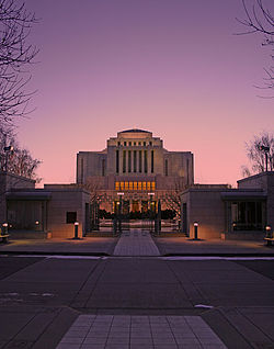
The Cardston Alberta Temple was constructed by Latter-day Saint pioneers from 1913-1923, and was the first temple constructed by the Church outside of the United States. [20] It remained the only temple in Canada until the Toronto Ontario Temple was built in 1990.

The Remington Carriage Museum is the largest collection of horse-drawn vehicles in North America, with more than 250 carriages, wagons and sleighs. The 63,000-square-foot (5,900 m2) facility features video displays, a fire hall, carriage factory, restoration shop, working stable, carriage rides, carriage rentals, a restaurant, guided tours, and a gift shop.

The Carriage House Theatre was constructed in 1912, and underwent renovations in 1937 and 1992. It seats 350 and hosts films, community theatre and professional summer theatre.[ citation needed ]

The Card Pioneer Home was built by Cardston's founder Charles Ora Card in 1887, and served as a community centre and stopping place for travellers until the first hotel was built in 1894. The log structure stands in its original location and is open for public visits. It is a registered provincial historic site. [21]

The Courthouse Museum is a sandstone structure built in 1907 from stone quarried near Cardston. It was used longer than any other courthouse in Alberta. The building displays the judge's bench, witness box, and jail cells. It is a registered provincial historic site. [22]

Education

Schools include the Cardston High School, the Cardston Jr. High School (formerly Eastridge Elementary School), and Cardston Elementary School which are all under the Westwind School Division.

Former schools include Leeside (grades 1 and 2 - torn down in the late 1980s to make way for the Remington-Alberta Carriage Centre) and Westside. The building that housed many of the junior high facilities, E.J. Wood School (including the gymnasium near the current high school), Parkland School, and John S. Smith Schools were torn down in 1993 as the junior high moved to the former Eastridge building. The Cardston High School underwent extensive renovations in the early 2000s, including an expansion to its gymnasium, much-improved fitness and weight room facilities, wider hallways, and a new cafeteria.[ citation needed ]

Media

The Cardston News was first published in 1924, and was a weekly until 1925. During 1924–1925, the newspaper was edited and published by Fred Burton. It was later taken over by D.O. Wight, editor and managing director from September 17, 1925 until June 9, 1936. Fred Burton took over as publisher on June 16, 1936. The Cardston News was taken over by Gordon F. West On May 7, 1964. [23] [24] The Cardston Record began publication on August 6, 1898, and was published weekly until September 1901. [23] [24]

Notable people

Fay Wray Fountain, Cardston Fay-Wray-Fountain.jpg
Fay Wray Fountain, Cardston

See also

Related Research Articles

<span class="mw-page-title-main">Magrath, Alberta</span> Town in Alberta, Canada

Magrath is a town in Cardston County, Alberta, Canada. Its population was 2,481 in 2021. Magrath is 32 km (20 mi) south of Lethbridge and 242 km (150 mi) south of Calgary.

<span class="mw-page-title-main">Milk River, Alberta</span> Town in Alberta, Canada

Milk River is a town in Alberta, Canada that is named after the Milk River which flows immediately to its south. This location results in Milk River being one of the few Canadian communities within the Mississippi River drainage system. It is 70 kilometres (43 mi) south of Lethbridge, and 16 kilometres (9.9 mi) from the Canada–United States border. It is primarily a service centre for the many farms and cattle ranches which surround it.

<span class="mw-page-title-main">Hanna, Alberta</span> Town in Alberta, Canada

Hanna is a town in Central Alberta, Canada.

<span class="mw-page-title-main">Oyen</span> Town in Alberta, Canada

Oyen is a town in east-central Alberta, Canada near the Saskatchewan boundary and north of Medicine Hat. It is on Highway 41, 4 km (2.5 mi) south of its junction with Highway 9.

<span class="mw-page-title-main">Olds, Alberta</span> Town in Alberta, Canada

Olds is a town in central Alberta, Canada within Mountain View County and the Calgary–Edmonton Corridor. It is approximately 61 km (38 mi) south of Red Deer and 90 km (56 mi) north of Calgary. The nearest towns are Didsbury to the south, Bowden to the north, Sundre to the west and Three Hills to the east. Olds is located at the intersection of Highway 27 and Highway 2A, 5 km (3.1 mi) west of the Queen Elizabeth II Highway. The Canadian Pacific Kansas City's main Edmonton-Calgary line runs through the town.

<span class="mw-page-title-main">Beaumont, Alberta</span> City in Alberta, Canada

Beaumont is a city in Leduc County within the Edmonton Metropolitan Region of Alberta, Canada. It is located at the intersection of Highway 625 and Highway 814, adjacent to the City of Edmonton and 6.0 kilometres (3.7 mi) northeast of the City of Leduc. The Nisku Industrial Park and the Edmonton International Airport are located 4.0 kilometres (2.5 mi) to the west and 8.0 kilometres (5.0 mi) to the southwest respectively.

<span class="mw-page-title-main">Vauxhall, Alberta</span> Town in Alberta, Canada

Vauxhall is a town in southern Alberta, Canada that is surrounded by the Municipal District of Taber. It is on Highway 36 approximately 36 km (22 mi) north of Taber, 69 km (43 mi) south of Brooks and 114 km (71 mi) west of Medicine Hat. It is situated in the prairie land between Bow River and Oldman River.

<span class="mw-page-title-main">Division No. 3, Alberta</span> Census division in Alberta, Canada

Division No. 3 is a census division in Alberta, Canada. It is located in the southwest corner of southern Alberta and its largest urban community is the Town of Claresholm.

<span class="mw-page-title-main">Grande Cache</span> Hamlet in Alberta, Canada

Grande Cache is a hamlet in West-Central Alberta, Canada within and administered by the Municipal District of Greenview No. 16. It is located on Highway 40 approximately 145 kilometres (90 mi) northwest of Hinton and 435 kilometres (270 mi) west of Edmonton. Grande Cache overlooks the Smoky River, is at the northern edge of Alberta's Rockies, and serves as a gateway to the Willmore Wilderness Park. The hamlet held town status prior to 2019.

<span class="mw-page-title-main">Rainbow Lake, Alberta</span> Town in Alberta, Canada

Rainbow Lake is a town in northwest Alberta, Canada. It is west of High Level at the end of Highway 58, in Mackenzie County.

<span class="mw-page-title-main">Raymond, Alberta</span> Municipality in Alberta, Canada (est. 1901)

Raymond is a town in southern Alberta, Canada that is surrounded by the County of Warner No. 5. It is south of Lethbridge at the junction of Highway 52 and Highway 845. Raymond is known for its annual rodeo during the first week of July and the large population of members of the Church of Jesus Christ of Latter-day Saints. Raymond is also significant for its connection to the history of the Japanese experience in Alberta. The town has a rich history in high school sports, basketball, Canadian football, Judo and women's rugby. Raymond was recently mentioned as one of the first communities in Alberta to become a net-zero solar-powered community, after having installed solar panels on most town buildings.

<span class="mw-page-title-main">Stavely</span> Town in Alberta, Canada

Stavely is a town in southern Alberta, Canada. It is located 110 kilometres (68 mi) south of Calgary on Highway 2 and 16 km (9.9 mi) east of Willow Creek Provincial Park.

Barnwell is a village in southern Alberta, Canada. It is located 10 km (6.2 mi) west of Taber and 43 km (27 mi) east of Lethbridge on Highway 3, in the Municipal District of Taber.

Glenwood is a village in southern Alberta, Canada. It is located north of the Town of Cardston, in Cardston County. The village was named for a man named Edward Glen Wood. The founder of the village was Edward J. Wood, successor to Latter Day Saint leader Charles Ora Card, the founder of Cardston. Both Glen and Edward Wood were from Salt Lake City, Utah, and are buried in Cardston. The old name for the village was Glenwoodville until 1979.

Hill Spring is a village in southern Alberta, Canada. It is located 32 km (20 mi) west of Cardston and 43 km (27 mi) southeast of Pincher Creek, in the foothills of the Canadian Rockies.

<span class="mw-page-title-main">Cardston County</span> Municipal district in Alberta, Canada

Cardston County is a municipal district in southern Alberta, Canada. It is located in Census Division 3 around the Town of Cardston.

Woolford is a hamlet in southern Alberta, Canada within Cardston County. It is located on Highway 503, approximately 16 kilometres (9.9 mi) southeast of Cardston between the St. Mary River and the Milk River Ridge. It is named after Thomas Woolford who came to the area in 1900.

<span class="mw-page-title-main">Waterton Park</span> Community in Alberta, Canada

Waterton Park, commonly referred to as Waterton, is a hamlet in southwestern Alberta, Canada within Improvement District No. 4 Waterton.

Mountain View is a hamlet in Alberta, Canada within Cardston County. It is located along Highway 5 approximately 25 kilometres (16 mi) west of Cardston and 20 kilometres (12 mi) east of Waterton Lakes National Park near the United States border. It is also a kickoff point for visitors to Police Outpost Provincial Park, 18 kilometers to the south.

Aetna is a hamlet in southern Alberta, Canada within Cardston County, located 2 kilometres (1.2 mi) east of Highway 2, approximately 70 kilometres (43 mi) southwest of Lethbridge.

References

  1. "Location and History Profile: Town of Cardston" (PDF). Alberta Municipal Affairs. October 7, 2016. p. 120. Retrieved October 13, 2016.
  2. "Municipal Officials Search". Alberta Municipal Affairs. May 9, 2019. Retrieved October 1, 2021.
  3. 1 2 3 "Population and dwelling counts: Canada, provinces and territories, and census subdivisions (municipalities)". Statistics Canada. February 9, 2022. Retrieved February 9, 2022.
  4. "Alberta Private Sewage Systems 2009 Standard of Practice Handbook: Appendix A.3 Alberta Design Data (A.3.A. Alberta Climate Design Data by Town)" (PDF) (PDF). Safety Codes Council. January 2012. pp. 212–215 (PDF pages 226–229). Archived from the original (PDF) on October 16, 2013. Retrieved October 8, 2013.
  5. "Population and dwelling counts: Canada and population centres". Statistics Canada. February 9, 2022. Retrieved February 13, 2022.
  6. "Municipal Census Results" . Retrieved September 21, 2018.
  7. Cardston Diamond Jubilee Committee (1962). Cardston jubilee : 1887-1962 : Jubilee Souvenir. p. 28. Archived from the original on March 3, 2017. Retrieved June 10, 2013.
  8. Shaw, Keith (1978). Chief mountain country : a history of Cardston and district. Volume I. Cardston: Cardston and District Historical Society. p. 45. ISBN   0-919213-89-8. Archived from the original on September 24, 2015. Retrieved June 13, 2013.
  9. 1 2 "Mayor of Cardston, Alberta, says 'party animal' citizens don't need alcohol in dry town | National Post". National Post. October 7, 2014. Retrieved February 3, 2020.
  10. Lawrence, Richard (January 15, 1951). "The Sober Truth About the Mormons". Maclean's .
  11. General, The Office of the Secretary to the Governor (November 12, 2020). "Town of Cardston [Civil Institution]". reg.gg.ca. Retrieved December 23, 2020.
  12. 1 2 "Cardston, Alberta". Canadian Climate Normals 1981–2010 (in English and French). Environment Canada. September 25, 2013. Retrieved March 10, 2014.
  13. 1 2 "July 2007". Canadian Climate Data (in English and French). Environment Canada. October 31, 2011. Retrieved May 20, 2016.
  14. "January 2015". Canadian Climate Data (in English and French). Environment Canada. October 31, 2011. Retrieved May 20, 2016.
  15. "Population and dwelling counts, for Canada, provinces and territories, and census subdivisions (municipalities), 2016 and 2011 censuses – 100% data (Alberta)". Statistics Canada. February 8, 2017. Retrieved February 8, 2017.
  16. "Statistics Canada. 2017. Cardston County, MD [Census subdivision]". Census Profile. 2016 Census. November 29, 2017. Retrieved February 3, 2020.
  17. "Mayor of cardston Alberta says party animal citizens don't need alcohol in dry town". nationalpost.com.[ dead link ]
  18. "CBC News". CBC. October 6, 2014. Retrieved July 30, 2020.
  19. Canada Flight Supplement. Effective 0901 Z 16 July 2020 to 0901Z 10 September 2020.
  20. Cardston, ULethbridge Digital Collection
  21. "Card Home".
  22. "Cardston & District Historical Society". Cardston & District Historical Society. Retrieved April 25, 2024.
  23. 1 2 Strathern, Gloria M. (1988). Alberta Newspapers, 1880-1982: An Historical Directory. University of Alberta Press. p. 56. ISBN   0-88864-137-0.
  24. 1 2 "UofL Library Digitized Collections - Southern Alberta Newspaper Collection". www.uleth.ca. Archived from the original on April 17, 2010. Retrieved March 14, 2022.
  25. "Elder Victor L. Brown Dies at 81," Ensign , May 1996, 105.
  26. "Elder Merlin R. Lybbert of the Second Quorum of the Seventy," Ensign , May 1989, 98.
  27. "Shawna Molcak," Olympic.ca/athletes, Retrieved July 27, 2020.
  28. "Strate, Grant", The Canadian Encyclopedia, accessed 2007-12-17.
  29. Jay M. Todd, "Edward J. Wood: 'Faith Personified'," Ensign , September 1988, 50.
  30. William Addams Reitwiesner, Ancestry of Fay Wray, accessed 2007-12-17.