Hodges, South Carolina

Last updated

Hodges, South Carolina
SCMap-doton-Hodges.PNG
Location of Hodges, South Carolina
Coordinates: 34°17′13″N82°14′47″W / 34.28694°N 82.24639°W / 34.28694; -82.24639
Country United States
State South Carolina
County Greenwood
Area
[1]
  Total0.78 sq mi (2.03 km2)
  Land0.78 sq mi (2.02 km2)
  Water0.00 sq mi (0.01 km2)
Elevation
699 ft (213 m)
Population
 (2020) [2]
  Total162
  Density207.43/sq mi (80.14/km2)
Time zone UTC-5 (Eastern (EST))
  Summer (DST) UTC-4 (EDT)
ZIP codes
29653, 29695
Area code 864
FIPS code 45-34225 [3]
GNIS feature ID1231390 [4]
Website www.facebook.com/townofhodges/

Hodges is a town in Greenwood County, South Carolina, United States. The population was 155 at the 2010 census. [5] The mayor is Michael George.

Contents

Hodges was named after Major General George Washington Hodges, who was commander of all of South Carolina's militia. Hodges was born September 9, 1792, and died March 24, 1876. He fought in the War of 1812. His grave is northeast of town in a hidden pre-Civil War cemetery.[ citation needed ]

Geography

Hodges is located in northern Greenwood County at 34°17′13″N82°14′47″W / 34.28694°N 82.24639°W / 34.28694; -82.24639 (34.286835, -82.246260). [6] U.S. Route 178 passes through the center of town, leading northwest 34 miles (55 km) to Anderson. U.S. Route 25 passes just east of the town, leading north 44 miles (71 km) to Greenville and south with US 178 8 miles (13 km) to Greenwood.

According to the United States Census Bureau, the town of Hodges has a total area of 0.77 square miles (2.0 km2), of which 1.513 acres (6,124 m2), or 0.30%, are water. [5]

Demographics

Historical population
CensusPop.Note
1880 271
1890 255−5.9%
1900 2570.8%
1910 2663.5%
1920 2846.8%
1930 2840.0%
1940 3036.7%
1950 275−9.2%
1960 209−24.0%
1970 2142.4%
1980 154−28.0%
1990 125−18.8%
2000 15826.4%
2010 155−1.9%
2020 1624.5%
U.S. Decennial Census [7] [2]

As of the census [3] of 2000, there were 158 people, 56 households, and 42 families residing in the town. The population density was 201.8 inhabitants per square mile (77.9/km2). There were 64 housing units at an average density of 81.7 per square mile (31.5/km2). The racial makeup of the town was 88.61% White, 7.59% African American, and 3.80% from two or more races.

There were 56 households, out of which 30.4% had children under the age of 18 living with them, 62.5% were married couples living together, 12.5% had a female householder with no husband present, and 25.0% were non-families. 23.2% of all households were made up of individuals, and 16.1% had someone living alone who was 65 years of age or older. The average household size was 2.82 and the average family size was 3.40.

In the town, the population was spread out, with 25.9% under the age of 18, 7.0% from 18 to 24, 27.2% from 25 to 44, 24.1% from 45 to 64, and 15.8% who were 65 years of age or older. The median age was 39 years. For every 100 females, there were 116.4 males. For every 100 females age 18 and over, there were 105.3 males.

The median income for a household in the town was $41,563, and the median income for a family was $46,875. Males had a median income of $32,083 versus $33,125 for females. The per capita income for the town was $14,564. About 18.6% of families and 15.2% of the population were below the poverty line, including 14.8% of those under the age of eighteen and 15.8% of those 65 or over.

Related Research Articles

<span class="mw-page-title-main">Greenwood, Illinois</span> Village in Illinois, United States

Greenwood is a village in McHenry County, Illinois, United States. It is a commuter village, part of the Chicago metropolitan area It was incorporated as a village on 4 April 1995. The population was 324 at the 2020 census.

<span class="mw-page-title-main">West Yarmouth, Massachusetts</span> Census-designated place in Massachusetts, United States

West Yarmouth is a census-designated place (CDP) in the town of Yarmouth in Barnstable County, Massachusetts, United States. The population was 6,012 at the 2010 census.

<span class="mw-page-title-main">Calhoun Falls, South Carolina</span> Town in South Carolina, United States

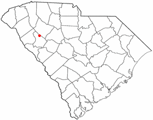
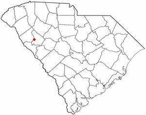
Calhoun Falls is a town in Abbeville County, South Carolina, United States. The population was 1,724 at the 2020 census, down from 2,004 at the 2010 census.

<span class="mw-page-title-main">Donalds, South Carolina</span> Town in South Carolina, United States

Donalds is a town in Abbeville County, South Carolina. As of the 2020 United States Census, its population was 328.

<span class="mw-page-title-main">Lowndesville, South Carolina</span> Town in South Carolina, United States

Lowndesville is a town in Abbeville County, South Carolina. The population was 120 at the 2020 census.

<span class="mw-page-title-main">Williamston, South Carolina</span> Town in South Carolina, United States

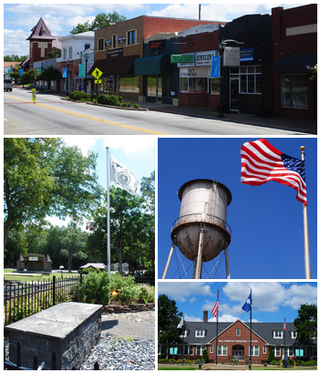
Williamston is a town in Anderson County, South Carolina. The population was 4,043 at the 2020 census.

<span class="mw-page-title-main">Hilda, South Carolina</span> Town in South Carolina, United States

Hilda is a town in Barnwell County, South Carolina, United States. The population was 447 at the 2010 census..

<span class="mw-page-title-main">Gantt, South Carolina</span> Census-designated place in South Carolina, United States

Gantt is a census-designated place (CDP) in Greenville County, South Carolina, United States. The population was 14,229 at the 2010 census. It is part of the Greenville–Mauldin–Easley Metropolitan Statistical Area and a suburb of the city of Greenville.

<span class="mw-page-title-main">Bradley, South Carolina</span> Census-designated place in South Carolina, United States

Bradley is an unincorporated community and census-designated place (CDP) in Greenwood County, South Carolina, United States. The population was 170 at the 2010 census.

<span class="mw-page-title-main">Cokesbury, South Carolina</span> Census-designated place in South Carolina, United States

Cokesbury is a census-designated place (CDP) in Greenwood County, South Carolina, United States. The population was 215 at the 2010 census, down from 279 in 2000.

<span class="mw-page-title-main">Coronaca, South Carolina</span> Census-designated place in South Carolina, United States

Coronaca is an unincorporated community and census-designated place (CDP) in Greenwood County, South Carolina, United States. The population was 191 at the 2010 census.

<span class="mw-page-title-main">Promised Land, South Carolina</span> Census-designated place in South Carolina, United States

Promised Land is an unincorporated community and census-designated place (CDP) in Greenwood County, South Carolina, United States. The population was 511 at the 2010 census.

<span class="mw-page-title-main">Troy, South Carolina</span> Town in South Carolina, United States

Troy is a town in Greenwood County, South Carolina, United States. The population was 93 at the 2010 census.

<span class="mw-page-title-main">Princeton, South Carolina</span> Census-designated place in South Carolina, United States

Princeton is an unincorporated community and census-designated place (CDP) in Laurens County, South Carolina, United States of America. The population was 62 at the 2010 census. It is part of the Greenville–Mauldin–Easley Metropolitan Statistical Area.

<span class="mw-page-title-main">Pelion, South Carolina</span> Town in South Carolina, United States

Pelion is a town in Lexington County, South Carolina, United States. The population was 674 at the 2010 census. It is part of the Columbia, South Carolina Metropolitan Statistical Area.

<span class="mw-page-title-main">Salem, South Carolina</span> Town in South Carolina, United States

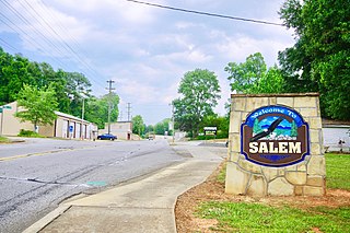
Salem is a U.S. town in Oconee County, South Carolina. The population was 135 at the 2010 United States Census.

Norris is a town in Pickens County, South Carolina, United States. The population was 813 at the 2010 census. It is part of the Greenville–Mauldin–Easley Metropolitan Statistical Area.

<span class="mw-page-title-main">St. Andrews, South Carolina</span> Census-designated place in South Carolina, United States

St. Andrews is a census-designated place (CDP) in Richland County, South Carolina, United States. The population was 20,493 at the 2010 census. It is part of the Columbia, South Carolina Metropolitan Statistical Area.

<span class="mw-page-title-main">Monetta, South Carolina</span> Town in South Carolina, United States of America

Monetta is a town in Aiken and Saluda counties, South Carolina, United States. The population was 236 at the 2010 census.

<span class="mw-page-title-main">Walpole (CDP), Massachusetts</span> Census-designated place in Massachusetts, United States

Walpole is a small census-designated place (CDP) located within the much larger town of Walpole in Norfolk County, Massachusetts, United States. Walpole Town as it is called by the US Census Bureau, also includes a much larger population. The population of the Census Designated Place was 5,918 at the 2010 census.

References

  1. "ArcGIS REST Services Directory". United States Census Bureau. Retrieved October 15, 2022.
  2. 1 2 "Census Population API". United States Census Bureau. Retrieved October 15, 2022.
  3. 1 2 "U.S. Census website". United States Census Bureau . Retrieved January 31, 2008.
  4. "US Board on Geographic Names". United States Geological Survey. October 25, 2007. Retrieved January 31, 2008.
  5. 1 2 "Geographic Identifiers: 2010 Demographic Profile Data (G001): Hodges town, South Carolina". American Factfinder. U.S. Census Bureau. Retrieved February 16, 2017.[ dead link ]
  6. "US Gazetteer files: 2010, 2000, and 1990". United States Census Bureau. February 12, 2011. Retrieved April 23, 2011.
  7. "Census of Population and Housing". Census.gov. Retrieved June 4, 2015.