Ninety Six, South Carolina

Last updated

Ninety Six, South Carolina
Starfortbattlefield.jpg
Sunset over the battlefield at Star Fort
SCMap-doton-NinetySix.PNG
Location of Ninety Six, South Carolina
Coordinates: 34°10′24″N82°1′18″W / 34.17333°N 82.02167°W / 34.17333; -82.02167
CountryUnited States
State South Carolina
County Greenwood
Government
  Type Mayor-council government
   Mayor Gregg Brown
Area
[1]
  Total1.82 sq mi (4.72 km2)
  Land1.82 sq mi (4.72 km2)
  Water0.00 sq mi (0.00 km2)
Elevation
548 ft (167 m)
Population
 (2020) [2]
  Total2,076
  Density1,139.41/sq mi (439.81/km2)
Time zone UTC−5 (Eastern (EST))
  Summer (DST) UTC−4 (EDT)
ZIP code
29666
Area code 864
FIPS code 45-50290 [3]
GNIS feature ID1249874 [4]
Website www.ninetysixsc.gov

Ninety Six is a town in Greenwood County, South Carolina, United States. The population was 2,076 at the 2020 census. [5]

Contents

Geography

Ninety Six is located in eastern Greenwood County at 34°10′24″N82°1′18″W / 34.17333°N 82.02167°W / 34.17333; -82.02167 (34.173211, -82.021710). [6] South Carolina Highway 34 passes through the town as its Main Street; it leads west 9 miles (14 km) to Greenwood, the county seat, and east 27 miles (43 km) to Newberry.

Lake Greenwood State Park is 5 miles (8 km) northeast of town, and Ninety Six National Historic Site is 2 miles (3 km) south of the center of town.

According to the United States Census Bureau, Ninety Six has a total area of 1.5 square miles (3.9 km2), all land. [5]

Etymology

There is much confusion about the name, "Ninety Six", and the true origin may never be known. Speculation has led to the mistaken belief that traders estimated it was 96 miles (154 km) from here to the nearest Cherokee settlement of Keowee (it was about 78 miles (126 km)); to a counting of creeks crossing the main road leading from Lexington, South Carolina, to Ninety-Six (a legend proved false); to an interpretation of a Welsh expression, nant-sych, meaning "dry gulch". No one is able to confirm that European founder Robert Goudey (sic) was Welsh, English, Scottish, or German.

Traders passed on information to each other about landmarks and distances along the Cherokee Path, and sometimes created maps. They estimated mileage between streams based on their day's travel. They noted unusual aspects, such as the six creeks that ran unexpectedly south away from the Saluda River and, further west, nine creeks that ran south away from the Savannah River, noting them on maps as "6" and "9". One story suggests that a town in this area and a district both became known as "Ninety-Six", likely related to the evolution of traders' references to 9 and 6, the landmark groups of streams. Using historical accounts and USGS maps, historians have traced the Cherokee Path across present-day Greenwood County, territory that at the time was part of other districts. [7]

Another source suggests the numerical reference was to measuring by Chain, traditional in English parishes. Even so, the origin of the name "Ninety-Six" remains a mystery. [8] Ninety Six has been noted for its unusual place name. [9]

History

Ninety Six was established on the frontier of the early 18th century, roughly around 1730. For a time it was known as "Jews Land" because some prominent Sephardic Jewish families of London bought extensive property there. The Salvador and DaCosta families bought 200,000 acres (810 km2), intending to help poor Sephardic families relocate from London to the New World. [10] They began to settle it. [11]

The settlement became the capital city of the Ninety-Six District when the latter was established in July 1769. Since the late 20th century, the National Park Service has operated the Ninety Six National Historic Site at the site of the original settlement and British fort.

Ninety Six figured prominently in the Anglo-Cherokee War (1758–1761). During the American Revolutionary War, it was a site for southern campaigns. The first land battle of the revolution south of New England was fought here November 19–21, 1775.

On August 1, 1776, American militia forces led by Major Andrew Williamson were ambushed by Cherokee and Loyalists near here in the Battle of Twelve Mile Creek. More than 4,000 Cherokee warriors had waged war on a long front beginning in June, from modern Tennessee to central South Carolina. [12] Francis Salvador, a Sephardic Jewish immigrant from London and a planter, was one of the casualties. He was the first Jew to be killed fighting with the Patriots in the Revolutionary War. [13]

The Cherokee were allied with the British in an effort to expel European-American settlers from their territory. In fall 1776, Virginia, North and South Carolina, and Georgia raised rebel militias to retaliate. Rutherford's Light Horse expedition had several units that attacked the Cherokee Lower Towns; the Middle, Valley, and Out Towns; and the Overhill Towns, dealing widespread destruction of Cherokee towns and their stores of food.

In 1780 the British fortified the strategically important frontier town with a star fort. From May 22 to June 18, 1781, Major General Nathanael Greene, with 1,000 Continental Army troops, besieged 550 American Loyalists who were defending Ninety Six. General Greene's chief engineer at the siege was Colonel Tadeusz Kościuszko, a Polish officer who became world-renowned for his role in the Revolution; he was wounded at the siege. The Loyalists survived the siege and relocated after the war to Rawdon, Nova Scotia, Canada, with support from the Crown for resettlement.

In the nineteenth century, the Southern Railway was constructed through here and had a stop at Ninety Six. The Kinard House, Moore-Kinard House, Ninety Six National Historic Site, and Southern Railway Depot (Ninety Six, South Carolina) are listed on the National Register of Historic Places. [14] [15]

In 2008, Ninety Six started hosting an annual July 4 celebration in the park. It is called the festival of stars and as of 2023 is still running in its 15th consecutive year. It has had many famous headliners at the festival including Tracy Lawrence and Aaron Tippin. The festival hosts a petting zoo, various food vendors, a multitude of booths selling items, rides, and even a helicopter ride. People in the town look forward to this annual celebration.

Demographics

Historical population
CensusPop.Note
1880 468
1890 445−4.9%
1900 414−7.0%
1910 75883.1%
1920 7732.0%
1930 1,38178.7%
1940 1,4535.2%
1950 1,5567.1%
1960 1,435−7.8%
1970 2,16650.9%
1980 2,2493.8%
1990 2,099−6.7%
2000 1,936−7.8%
2010 1,9983.2%
2020 2,0763.9%
U.S. Decennial Census [16] [2]

2020 census

Ninety Six racial composition [17]
RaceNum.Perc.
White (non-Hispanic)1,51873.12%
Black or African American (non-Hispanic)43420.91%
Native American 20.1%
Asian 10.05%
Pacific Islander 10.05%
Other/Mixed 743.56%
Hispanic or Latino 462.22%

As of the 2020 United States census, there were 2,076 people, 706 households, and 520 families residing in the town.

2000 census

As of the census [3] of 2000, there were 1,936 people, 820 households, and 560 families residing in the city. The population density was 1,325.1 inhabitants per square mile (511.6/km2). There were 904 housing units at an average density of 618.7 per square mile (238.9/km2). The racial makeup of the town was 76.50% White, 22.73% Black, 0.15% Native American, 0.05% Asian, 0.21% from other races, and 0.36% from two or more races. Hispanic or Latino of any race were 0.52% of the population.

There were 820 households, out of which 30.1% had children under the age of 18 living with them, 47.1% were married couples living together, 17.6% had a female householder with no husband present, and 31.6% were non-families. 29.3% of all households were made up of individuals, and 16.0% had someone living alone who was 65 years of age or older. The average household size was 2.36 and the average family size was 2.90.

In the town, the age distribution of the population shows 24.9% under the age of 18, 7.4% from 18 to 24, 27.7% from 25 to 44, 22.9% from 45 to 64, and 17.1% who were 65 years of age or older. The median age was 38 years. For every 100 females, there were 81.1 males. For every 100 females age 18 and over, there were 78.0 males.

The median income for a household in the town was $33,423, and the median income for a family was $39,550. Males had a median income of $30,978 versus $25,034 for females. The per capita income for the town was $15,648. About 7.0% of families and 8.3% of the population were below the poverty line, including 8.6% of those under age 18 and 8.7% of those age 65 or over.

Education

Ninety Six has a public library, a branch of the Greenwood County Library System. [18]

Notable people

The 1781 siege was described in William Gilmore Simms' novel, The Forayers (1855). It is also featured in Kenneth Roberts' novel, Oliver Wiswell (1940), which includes a chapter entitled "Ninety-Six".

The town is mentioned in the song "This Old Skin" by The Beautiful South.

See also

Related Research Articles

<span class="mw-page-title-main">Clay County, North Carolina</span> County in North Carolina, United States

Clay County is a county located in the far western part of U.S. state North Carolina. As of the 2020 census, the county population was 11,089. The county seat is Hayesville.

<span class="mw-page-title-main">Union County, South Carolina</span> County in South Carolina, United States

Union County is a county located in the U.S. state of South Carolina. As of the 2020 census, the population was 27,244. Its county seat is Union. The county was created in 1785.

<span class="mw-page-title-main">Oconee County, South Carolina</span> County in South Carolina, United States

Oconee County is the westernmost county in the U.S. state of South Carolina. As of the 2020 census, the population was 78,607. Its county seat is Walhalla and its largest community is Seneca. Oconee County is included in the Seneca, SC Micropolitan Statistical Area, which is also included in the Greenville-Spartanburg-Anderson, SC Combined Statistical Area. South Carolina Highway 11, the Cherokee Foothills National Scenic Highway, begins in southern Oconee County at Interstate Highway 85 at the Georgia state line.

<span class="mw-page-title-main">Greenwood County, South Carolina</span> County in South Carolina, United States

Greenwood County is a county located in the U.S. state of South Carolina. As of the 2020 census, its population was 69,351. Its county seat is Greenwood.

<span class="mw-page-title-main">Cherokee County, South Carolina</span> County in South Carolina, United States

Cherokee County is a county in the U.S. state of South Carolina. As of the 2020 census, the population was 56,216. The county seat is Gaffney. The county was formed in 1897 from parts of York, Union, and Spartanburg counties. It was named for the Cherokee people who historically occupied this area prior to European encounter.

<span class="mw-page-title-main">Abbeville County, South Carolina</span> County in South Carolina, United States

Abbeville County is a county located in the U.S. state of South Carolina. As of the 2020 census, its population was 24,295. Its county seat is Abbeville. It is the first county in the United States alphabetically. Abbeville County included in the Greenville-Spartanburg-Anderson, SC Combined Statistical Area, known colloquially as the Upstate or the Upcountry.

<span class="mw-page-title-main">Canton, North Carolina</span> Town in North Carolina, United States

Canton is the second largest town in Haywood County, North Carolina, United States. It is located about 17 miles (27 km) west of Asheville and is part of that city's metropolitan area. The town is named after the city of Canton, Ohio. The population was 4,422 at the 2020 census.

<span class="mw-page-title-main">Due West, South Carolina</span> Town in South Carolina, United States

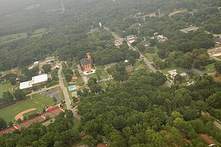
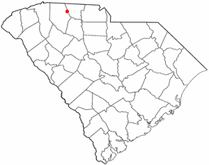
Due West is a town in Abbeville County, South Carolina. The population was 1,247 at the 2010 census. It is the home of Erskine College and Dixie High School.

<span class="mw-page-title-main">Blacksburg, South Carolina</span> Town in South Carolina, United States

Blacksburg is a small town in Cherokee County, South Carolina, United States. The population was 1,848 at the 2010 census. The communities of Antioch, Cherokee Falls, Kings Creek, Cashion Crossroads, Buffalo, and Mount Paran are located near the town.

<span class="mw-page-title-main">Gaffney, South Carolina</span> City in South Carolina, United States

Gaffney is a city in and the seat of Cherokee County, South Carolina, United States, in the Upstate region of South Carolina. Gaffney is known as the "Peach Capital of South Carolina". The population was 12,539 at the 2010 census, with an estimated population of 12,609 in 2019. It is the principal city of the Gaffney, South Carolina, Micropolitan Statistical Area, which includes all of Cherokee County and which is further included in the greater Greenville-Spartanburg-Anderson, South Carolina Combined Statistical Area.

<span class="mw-page-title-main">Cheraw, South Carolina</span> Town in South Carolina, United States

Cheraw is a town on the Pee Dee River in Chesterfield County, South Carolina, United States. The population was 5,040 at the 2020 census. The greater Cheraw area in the zip code 29520 has a population of 13,689 according to the 2019 ACS data. It has been nicknamed "The Prettiest Town in Dixie".

<span class="mw-page-title-main">Pickens, South Carolina</span> City in South Carolina, United States

Pickens, formerly called Pickens Courthouse, is a city in and the county seat of Pickens County, South Carolina, United States. The population was 3,126 at the 2010 census. Pickens changed its classification from a town to a city in 1998, but it was not reported to the Census Bureau until 2001. It was named after Andrew Pickens (1739–1817), an American revolutionary soldier and US Congressman for South Carolina.

<span class="mw-page-title-main">Cowpens, South Carolina</span> Town in South Carolina, United States

Cowpens is a town in Spartanburg County, South Carolina, United States. The population was 2,162 at the 2010 census. The town was chartered February 20, 1880, and was incorporated in 1900.

<span class="mw-page-title-main">Chesnee, South Carolina</span> City in South Carolina, United States

Chesnee is a city in Spartanburg and Cherokee counties, in the U.S. state of South Carolina. The population was 868 as of the 2010 census.

Francis Salvador was an English-born American plantation owner in the colony of South Carolina from the Sephardic Jewish community of London; in 1774 he was the first professing Jew to be elected to public office in the colonies when chosen for the Provincial Congress. He had joined the independence cause and in 1776 was the first Jew killed in the American Revolutionary War, fighting with the militia on the South Carolina frontier against Loyalists and their Cherokee allies.

The Cherokee Path was the primary route of English and Scots traders from Charleston to Columbia, South Carolina in Colonial America. It was the way they reached Cherokee towns and territories along the upper Keowee River and its tributaries. In its lower section it was known as the Savannah River. They referred to these towns along the Keowee and Tugaloo rivers as the Lower Towns, in contrast to the Middle Towns in Western North Carolina and the Overhill Towns in present-day southeastern Tennessee west of the Appalachian Mountains.

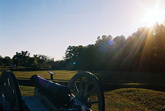
Ninety Six National Historic Site, also known as Old Ninety Six and Star Fort, is a United States National Historic Site located about 60 miles south of Greenville, South Carolina. The historic site was listed on the National Register in 1969, declared to be a National Historic Landmark in 1973, and established as a National Historic Site in 1976 to preserve the original site of Ninety Six, South Carolina, a small town established in the early 18th century. It encompasses 1,022 acres of property.

Ninety-Six District is a former judicial district in the U.S. state of South Carolina. It existed as a district from July 29, 1769 to December 31, 1799. The court house and jail for Ninety-Six District were in Ninety Six, South Carolina.

Brigadier-General Andrew Williamson was a Scottish-born trader, planter, and military officer. Serving in the South Carolina Militia, rising to be commissioned as brigadier general in the Continental Army in the American War of Independence. He led numerous campaigns against Loyalists and Cherokee, who in 1776 had launched an attack against frontier settlements across a front from Tennessee to central South Carolina. Williamson was particularly effective in suppressing the Cherokee, killing an unknown number of Cherokees and destroying 31 of their towns. As a result of his Indian campaign, the Cherokee ceded more than a million acres in the Carolinas.

<span class="mw-page-title-main">Snow Campaign</span> Military conflict in the American revolutionary war

The Snow Campaign was one of the first major military operations of the American Revolutionary War in the southern colonies. An army of up to 3,000 Patriot militia under Colonel Richard Richardson marched against Loyalist recruiting centers in South Carolina, flushing them out and frustrating attempts by the Loyalists to organize. The Patriot expedition became known as the Snow Campaign due to heavy snowfall in the later stages of the campaign.

References

  1. "ArcGIS REST Services Directory". United States Census Bureau. Retrieved October 15, 2022.
  2. 1 2 "Census Population API". United States Census Bureau. Retrieved October 15, 2022.
  3. 1 2 "U.S. Census website". United States Census Bureau . Retrieved January 31, 2008.
  4. "US Board on Geographic Names". United States Geological Survey. October 25, 2007. Retrieved January 31, 2008.
  5. 1 2 "Geographic Identifiers: 2010 Demographic Profile Data (G001): Ninety Six town, South Carolina". American Factfinder. U.S. Census Bureau. Retrieved February 16, 2017.[ dead link ]
  6. "US Gazetteer files: 2010, 2000, and 1990". United States Census Bureau. February 12, 2011. Retrieved April 23, 2011.
  7. George, David P. Jr (April 1991). "Ninety Six Decoded: Origins of a Community's Name". The South Carolina Historical Magazine. 92 (2): 69–84. JSTOR   27568211.via JSTOR
  8. Guinn, Dr. Gilbert; Geraldine Beach; Rose Mitchell (2004). Maps for Family and Local History (2nd revised ed.). Tonawanda, New York: Dundurn Press. p. 35.[ need quotation to verify ]
  9. "The most ridiculous town name in each state". WKRC. Retrieved August 9, 2020.
  10. Pencak, William (2005). Jews and Gentiles in Early America 1654–1800. Ann Arbor: University of Michigan Press. p. 124. ISBN   978-0-472-11454-2.
  11. Pencak, Jews and Gentiles in Early America 1654–1800, p. 124.
  12. Toulmin, Llewellyn M. (Spring 2012). "Backcountry Warrior: Brig. Gen. Andrew Williamson". Journal of Backcountry Studies. 7 (1).
  13. Porter Brown, Nell (January–February 2003). "A 'Portion of the People'". Harvard Magazine .
  14. "National Register Information System". National Register of Historic Places . National Park Service. July 9, 2010.
  15. "National Register of Historic Places Listings". Weekly List of Actions Taken on Properties: 10/03/11 through 10/07/11. National Park Service. November 14, 2011.
  16. "Census of Population and Housing". Census.gov. Retrieved June 4, 2015.
  17. "Explore Census Data". data.census.gov. Retrieved December 10, 2021.
  18. "Locations & Hours". Greenville County Library System. Retrieved June 8, 2019.
  19. (March 26, 1904). About Authors, The New York Times
  20. Odean Pope website

Further reading