Homa Bay

Last updated

Homa Bay
Homa Bay City (2023).jpg
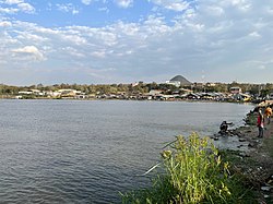
Homa Bay Skyline captured from a pier in Lake Victoria, 2023
Kenya adm location map.svg
Red pog.svg
Homa Bay
Location in Kenya
Coordinates: 0°31′S34°27′E / 0.517°S 34.450°E / -0.517; 34.450
CountryFlag of Kenya.svg  Kenya
County Homa Bay County
Population
 (2019)
  Total44,949
Time zone UTC+3 (EAT)
Climate Aw

Homa Bay is a town (and eponymous bay) on the south shore of Winam Gulf of Lake Victoria, in western Kenya. It lies near Mount Homa (in the Luo language Got Marahuma or God Uma ["famous mountain"]) and Ruma National Park, the latter noted for Jackson's hartebeests and roan antelope (the government has also released reticulated giraffes into the park).

Contents

Homa Bay was once the District Headquarters for all of South Nyanza District, Nyanza Province, but has now been divided into at least three districts. Homa Bay is now capital of Homa Bay County per the new constitution. The town of Homa Bay hosts a Municipal Council. The municipality has a population of 44,949 in 2019. [1]

Homa Bay municipality has six wards: Central, Kalanya, Kanyabala, Kanyadier/Kothidha, Katuma and Posta/Bonde. All of them belong to Rangwe Constituency, which has a total of fourteen wards. The remaining eight are located within Homa Bay County Council, the rural council of Homa Bay District. [2]

See also

Related Research Articles

<span class="mw-page-title-main">Kisii, Kenya</span> Municipality in Kisii County, Kenya

Kisii is a municipality and urban centre in south-western Kenya and the capital of the Kisii County. Kisii Town also serves as major urban and commercial centre in the Gusii Highlands—Kisii and Nyamira counties—and the South Nyanza region and the second largest town in formerly greater Nyanza after Kisumu City. Kisii municipality sits right at the centre of the western Kenya tourist circuit that includes the Tabaka Soapstone Carvings, Maasai Mara, Ruma National Park and part of the Lake Victoria Basin.

Mbita Point is a town in the former province of Nyanza, Kenya, currently in Homa Bay County, on the shores of Lake Victoria. It is home to the Thomas Odhiambo campus of the International Centre of Insect Physiology and Ecology (ICIPE). A public primary school formerly international and a clinic are hosted by the centre. Mbita has several other primary schools as well as secondary schools. A small sub-district hospital is in the town. The main district hospital is in the neighbouring town of Sindo, 17 km away. Mbita has had water and electricity since 2005. Mbita Point has an urban population of 6100, but the population grows rapidly due to urbanization, new technologies like cell phone coverage and internet connection through cyber cafes, electrification, trade and education. The town was the capital of the former Suba District.

<span class="mw-page-title-main">Kisumu County</span> County in Kenya

Kisumu County is one of 47 counties in the Republic of Kenya. Its borders follow those of the original Kisumu District, one of the former administrative districts of the former Nyanza Province in western Kenya. Its headquarters is Kisumu City which is the third largest city in Kenya after the capital Nairobi and the coastal city of Mombasa. It has a population of 1,155,574. The land area of Kisumu County totals 2085.9 km2.

<span class="mw-page-title-main">Siaya County</span> County in Kenya

Siaya County is one of the counties in the former Nyanza Province in the Western part of Kenya. It is bordered by Busia County to the north, Kakamega County and Vihiga County's to the northeast and Kisumu County to the southeast. It shares a water border with Homa Bay County which is located south of Siaya County. The total area of the county is approximately 2,496.1 km2. The county lies between latitude 0° 26' to 0° 18' north and longitude 33° 58' east and 34° 33' west. Siaya has been split up into six new districts. Under the Constitution 2010, the role of districts are still unclear as much of administrative authority is being transferred to the county. The capital is Siaya, even though the largest town is Bondo.

<span class="mw-page-title-main">Siaya</span>

Siaya is a town in Siaya County of Kenya. It is the capital of Siaya County. It is located 74 km (46 mi) northwest of Kisumu. The urban center had a population of 33,153 in 2019.

<span class="mw-page-title-main">Nyamira County</span> County in Kenya

Nyamira County is a county in the former Nyanza Province of Kenya. It shares common boundaries with what was known as Nyamira District. The main cash crops grown are bananas and tea. The county has a population of 605,576. Its capital and largest town is Nyamira, with an urban population of around 41,668

<span class="mw-page-title-main">Local authorities of Kenya</span> Bodies controlling local governance in urban areas in Kenya

Local authorities in Kenya are the bodies controlling local governance in urban areas in Kenya.

<span class="mw-page-title-main">Homa Bay County</span> County in Kenya

Homa Bay County is a county in the former Nyanza Province of Kenya. Its capital and largest town is Homa Bay. The county has a population of 1,131,950 and an area of 3,154.7 km2. Lake Victoria is a major source of livelihood for Homa Bay County. It has 40 wards, each represented by an MCA to the assembly in Homa Bay town as its headquarters.

Rachuonyo District was an administrative district in the Nyanza Province of Kenya. Its capital town was Kosele, and previously, Oyugis. The district had a population of 307,126 and an area of 945 km². The district had two constituencies, Kasipul Kabondo and Karachuonyo, which have been part of Homa Bay County since 2010.

<span class="mw-page-title-main">Migori County</span> County in Kenya

Migori County is a county in the former Nyanza Province of southwestern Kenya. It is located in Southwestern Kenya and borders Homa Bay County (North), Kisii County, Narok, Tanzania and Lake Victoria to the West. The county also borders Uganda via Migingo Island in Lake Victoria. The county is headquartered by Migori town, which is also its largest town. The Kenya National Census of 2019 indicated that Migori County had a population of 1,116,436 compared to 917, 170 in 2009 Census. Migori County is located in the sugar belt wetlands of Western Kenya and is mostly at the heart of the African tropics. However, the county enjoys a pleasant climate because of high altitude which modifies the climate alongside the cool breeze from Lake Victoria.

Suba District was an administrative district in the former Nyanza Province of Kenya. Its capital town was Mbita Point. The district had a population of 155,666 and an area of 1,055 km². Suba district was named after the Suba people, who inhabit local Rusinga and Mfangano Islands.

Karatina is a town in Nyeri County, Kenya. It hosts a municipal council and the headquarters of Mathira East district. Karatina municipality has a total population of 6,852, all classified as urban. It has six electoral wards, all in the Mathira Constituency; the remaining five wards of Mathira constituency represent Nyeri County Council.

<span class="mw-page-title-main">Bondo, Kenya</span>

Bondo is a town in Siaya County of Kenya. It has traditionally been a fishing town and its entire economy rotates around the fish from Lake Victoria. It the largest and most populous town of the county. Located 64 kilometers West of Kisumu, Bondo was established in the early 1920s as a market centre. In the 1990s, it became the headquarters of Bondo district which was carved out of the larger Siaya District.

Oyugis is the second-largest town in Homa Bay County in western Kenya. The town lies along the Kisumu-Kisii highway. It is the commercial and financial centre of Rachuonyo Sub-County in Homa Bay County of the former Nyanza Province.

<span class="mw-page-title-main">Kendu Bay</span>

Kendu Bay is a bay and town in Kenya. The area is the part of Rachuonyo North District in Homa Bay County. It is located on the shore of Lake Victoria along Katito-Homa-Bay road. It is the headquarters of the district. Kisumu, the largest urban centre in Kenya's western region, is located 40 kilometres north of Kendu Bay, but the route to Kisumu, which goes via Ahero, is much longer as it circumvents Winam Gulf in between kisumu- Ahero- Katito- Kendu Bay is 70 km from Kisumu town. Kendu Bay is also linked by a road to Homa Bay, located 30 kilometres southwest.

<span class="mw-page-title-main">Kisii County</span> County in Kenya

Kisii County is a county in the former Nyanza Province in southwestern Kenya. Its capital and largest town is Kisii. The county has a population of 1,266,860 people. It borders Nyamira County to the North East, Narok County to the South, and Homabay and Migori Counties to the West. The county covers an area of 1,317.5 km.

Ndhiwa Constituency is an electoral constituency in Kenya. It is one of eight constituencies in Homa Bay County. The constituency has seven wards, all electing councillors to the Homa Bay County Council.

Gwassi Constituency was an electoral constituency in Kenya. It was one of two constituencies in the former Suba District, which has since been merged into Homa Bay County. The constituency had seven wards, all electing councillors to the Suba County Council.

Sori (Suri) is a small town in Migori County, in the former Nyanza Province of Kenya. The town lies on the banks of Lake Victoria. As of 2009, its population is 8,964.

<span class="mw-page-title-main">Sub-Counties of Kenya</span>

Sub-counties are the decentralised units through which county governments of Kenya will provide functions and services. Except for the parts which fall under urban areas, sub-counties will coincide with the constituencies created under article 89 of the Constitution of Kenya. Sub-counties will be headed by a sub-county administrator, appointed by a County Public Service Board.

References

  1. "2019 Kenya Population and Housing Census Volume II: Distribution of Population by Administrative Units". Kenya National Bureau of Statistics. Retrieved 28 March 2020.
  2. Electoral Commission of Kenya: Registration centres by electoral area and constituency Archived 2007-06-28 at the Wayback Machine

Coordinates: 0°31′S34°27′E / 0.517°S 34.450°E / -0.517; 34.450